
面向中国洪涝灾害应急监测的无人机空港布局
作者简介:鹿明(1987-),男,山东淄博人,博士后,主要从事无人机遥感观测网,无人机空港选址布局等研究。E-mail: lum@lreis.ac.cn
收稿日期: 2018-04-10
要求修回日期: 2019-04-18
网络出版日期: 2019-06-15
基金资助
国家自然科学基金项目(41771388)
国家重点研发计划项目(2017YFB0503005)
博士后基金项目(2018M640170)
Determining the Distribution of Unmanned Aerial Vehicles Airports for the Emergency Monitoring of Floods in China
Received date: 2018-04-10
Request revised date: 2019-04-18
Online published: 2019-06-15
Supported by
National Natural Science Foundation of China, No.41771388
National Key Research and Development
Program of China, No.2017YFB0503005
Postdoctoral Science Foundation of China, No.2018M640170
Copyright
当前洪涝灾害对社会的经济发展和人民生命财产安全构成严重威胁。无人机机动、灵活,安全性高,可迅捷甚至实时获取灾区影像,对灾情的快速评估和应急救援决策意义重大。遥感无人机在洪涝灾害救援中能够发挥的重要作用已得到广泛共识,但是由于灾害的突发性,缺乏就近部署的资源制约了无人机遥感观测和救援作用的发挥。针对突发灾害,在区域和全国范围内建立起一定的无人机遥感应急体系成为国家面向未来正在考虑的选项。基于此,本研究提出了基于中国科学院的野外台站构建全国无人机遥感观测网的设想。本研究以中国防范洪涝灾害等级分布数据、行政区划数据、中国科学院野外台站分布数据和当前无人机性能数据库为数据源;以行政区划离散并提取的中心点作为需求点,台站作为设施点,不同洪涝等级区域内需要无人机进行应急观测的重要程度作为权重,利用最大覆盖选址模型进行空港选址布局;利用成本-效益曲线确定台站的最佳数量,最终从268个台站中选取出81个作为支撑全国洪涝灾害无人机遥感观测网络的无人机空港。无人机空港布局结果在理论上能够实现对中国绝大数突发洪涝灾害在2 h内初步完成洪涝观测,这对于构建中国空天地一体化的洪涝灾害监测体系具有重要意义。同时,本研究中的方法和成果对于进一步构建行业和综合性的全国无人机遥感观测网也具有一定借鉴和参照意义。
鹿明 , 廖小罕 , 岳焕印 , 黄诗峰 , 徐晨晨 , 卢海英 , 柏艺琴 . 面向中国洪涝灾害应急监测的无人机空港布局[J]. 地球信息科学学报, 2019 , 21(6) : 854 -864 . DOI: 10.12082/dqxxkx.2019.180177
Frequent flood hazards affect large areas and cause great losses, which have posed a serious threat to economic development and people's lives and properties. Unmanned Aerial Vehicles (UAVs) have proven to be useful in monitoring disaster status and providing decision-making support for emergency rescue, because they are able to arrive at floods area timely, obtain flood images and videos quickly, low-risk to operate and flexible to carry out different sensors. The important roles of UAV in emergency rescue have been widely recognized. However, the lack of available UAV resources nearby at the sudden onset of floods seriously limits the capability of UAVs' rapid response to flood disasters. For addressing this challenge, a multi-UAVs remote sensing observation network is highly required, and now has been planned in China to enhance our ability of emergency response. Key problems include where and how to allocate UAVs resources such that the UAVs can reach destination timely when floods occur. To help close this gap, we proposed to build a number of UAV airports in China to establish a remote sensing observation network of UAVs. Field stations of Chinese Academy of Science (CAS) were considered as the potential locations of UAV airports because of their extensive geographical distribution and good cooperation with the UAV application and regulation research center of CAS. With the available flood risk prevention data, administrative division data, CAS field stations data and the UAV database as data sources, we created a fishnet of 0.5° multiply 0.5° to discretize administrative divisions and regarded the central points of these grids as potential demand points, and then calculated the importance of UAV to those demand points based on their flood risk prevention level. Based on this analysis, a Maximum Covering Location Problem (MCLP) model was adopted to determine the optimum stations for UAV airports and a cost-effectiveness curve was used to determine the optimum number of UAV airports. In the end, 81 field stations were selected from 268 field stations, thereby ensuring that UAV airports would be allocated near flood-prone areas and most floods in China could be monitored with UAVs within two hours, which is critical for saving lives and reducing losses. The construction of UAV airport networks will surely contribute to an integrated disaster emergency observation system combining satellite, airplane, UAV and ground observations in China. Additionally, the methods and results in this study can serve as a basis for building a more comprehensive national UAV remote sensing observation network.
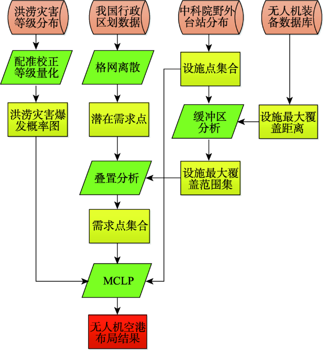
Fig. 1 Flowchart of determining the UAV airport locations for flood observation图1 面向洪涝灾害的无人机空港选址流程 |
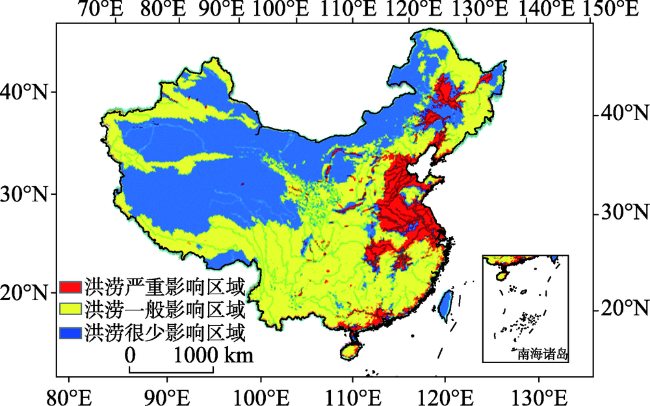
Fig. 2 Map of flood-prevention risk in China图2 中国预防洪涝灾害等级分布 |
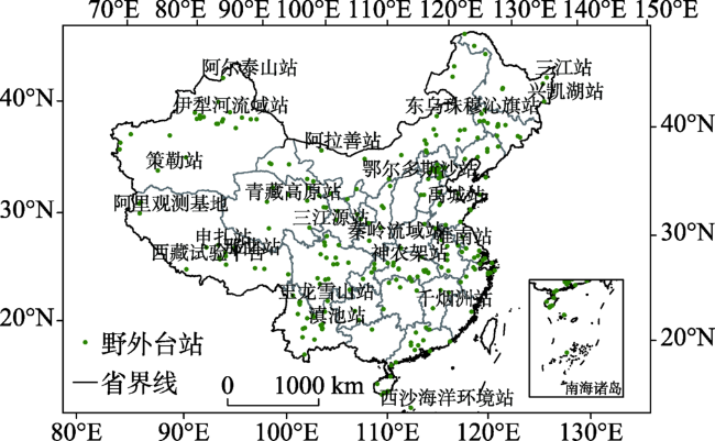
Fig. 3 Distribution map of CAS field stations(2019)图3 中国科学院野外台站分布(2019年) |
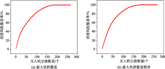
Fig. 4 Cost-effective curves of maximum area covered and maximum flood risk coveredunder 90km service distance of UAV airports图4 无人机空港在90 km最大服务距离条件下最大面积覆盖和最大洪涝覆盖模型的成本-效益曲线 |
Tab. 1 Evaluation of the MCLP solutions: maximum area versus maximum flood risk表1 最大面积和最大洪涝条件下的覆盖能力评价 |
| 覆盖需求点 | 未覆盖需求点 | 洪涝等级覆盖率/% | |
|---|---|---|---|
| 最大面积MCLP | 853 | 564 | 62.5 |
| 最大洪涝MCLP | 743 | 674 | 76.1 |
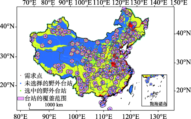
Fig. 5 Selected 81 UAV airports that cover the largest areas图5 最大面积条件下选取的81个空港 |
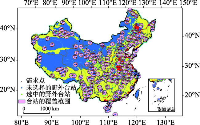
Fig. 6 Selected 81 UAV airports that cover the largest flood risk图6 最大洪涝风险条件下选取的81个空港 |
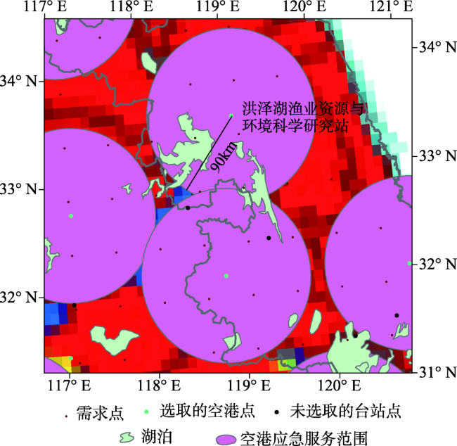
Fig. 7 Droneport and its 90 km emergency service area in the Hongze Lake region图7 洪泽湖流域与无人机空港及其90 km应急观测范围的空间分布 |
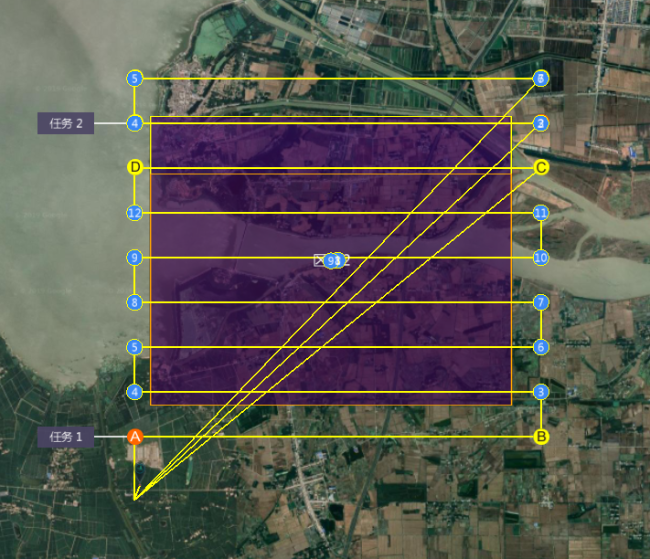
Fig. 8 UAV flight path in the Hongze Lake region图8 洪泽湖口无人机作业区域航拍路径 |
The authors have declared that no competing interests exist.
| [1] |
[
|
| [2] |
[
|
| [3] |
[
|
| [4] |
|
| [5] |
|
| [6] |
[
|
| [7] |
|
| [8] |
[
|
| [9] |
[
|
| [10] |
[
|
| [11] |
[
|
| [12] |
[
|
| [13] |
[
|
| [14] |
[
|
| [15] |
[
|
| [16] |
|
| [17] |
|
| [18] |
|
| [19] |
|
| [20] |
|
| [21] |
[
|
| [22] |
[
|
| [23] |
[
|
| [24] |
[
|
| [25] |
国家遥感中心.无人机遥感系统信息库[EB/OL]. , 2012.
[ National Remote Sensing Center of China. UAV remote sensing system information database[EB/OL]. , 2012. ]
|
| [26] |
[
|
| [27] |
[
|
/
| 〈 |
|
〉 |