
基于DEM的SAR影像几何定位参数校正方法
作者简介:杨书成(1986-),男,江西万年人,博士,副研究员,研究方向为SAR遥感数据处理及应用。E-mail:yangsc@casm.ac.cn
收稿日期: 2018-08-24
要求修回日期: 2019-03-15
网络出版日期: 2019-04-24
基金资助
国家重点研发计划项目(2017YFB0503004、2018YFF0215303)
中国测绘科学研究院基本科研业务费项目(777 1808)
Correction Method of SAR Image Geometric Positioning Parameters based on DEM
Received date: 2018-08-24
Request revised date: 2019-03-15
Online published: 2019-04-24
Supported by
The National Key Research and Development Program of China, No.2017YFB0503004, 2018YFF0215303
Chinese Academy of Surveying and Mapping Fundamental Research Project under Grant, No. 7771808
Copyright
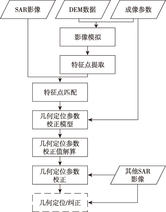
针对大范围无地面控制的SAR影像几何纠正,利用在一定时间和空间范围内SAR系统几何定位参数误差具有一定稳定性的特点,提出基于DEM的几何定位参数校正方法。该方法首先基于DEM进行影像模拟生成模拟SAR影像;然后在模拟SAR影像上提取特征点,针对特征点将模拟SAR影像和原始SAR影像进行匹配,得到特征点在原始SAR影像上的同名特征点,再结合DEM进行模拟影像间接定位获取特征点的地理坐标,以此作为几何定位参数校正的参考点;进而根据严密SAR几何构像模型构建几何定位参数校正模型,解算几何定位参数校正值;最后,利用几何参数校正值改正区域内其他SAR影像几何定位参数,提高区域内SAR影像几何定位精度。以高分三号影像进行试验,使用本文方法获取一景影像的几何定位参数校正值,对同一轨道内的和不同轨道的其他SAR影像进行参数校正,并对参数校正前后的几何定位精度进行评价。结果显示,同一轨道内的影像定位精度由66.0 m提高到9.7 m,不同轨道的影像定位精度由65.0 m提高到13.5 m,表明本文方法能够显著提高SAR影像几何定位精度。
杨书成 , 黄国满 , 程春泉 . 基于DEM的SAR影像几何定位参数校正方法[J]. 地球信息科学学报, 2019 , 21(4) : 580 -587 . DOI: 10.12082/dqxxkx.2019.180386
For geometric correction of SAR image without ground control point in large area, method of geometric positioning parameters correction based on DEM is proposed in this paper. The basis of this method is that the static error of geometric positioning parameters is stable in short time and certain area. Firstly, simulation SAR Image is generated based on DEM. Then, feature points are extracted on the Simulation SAR Image. Corresponding image point of these feature points on original SAR image are extracted by image matching between simulation Image and original SAR image. And the geographic coordinates of these feature points are got by indirect geolocation with DEM. The image points on original SAR image with geographic coordinates are used for reference points of geometric positioning parameters correction. And then, the correction model is established according to rigorous geometric imaging model of SAR image and correction values of geometric positioning parameters are solved with the reference points. Finally, geometric positioning parameters of other SAR images in certain area are corrected with the values, and geometric correction accuracy of SAR images in this area is improved. GF-3 SAR images were used in experiments. The correction values of geometric positioning parameters were obtained from one image. Geometric positioning parameters of other images in the same orbit and in different orbits were corrected. The geometric positioning accuracy before and after parameters correction was evaluated. Geometric positioning accuracy of the image in the same orbit improved from 66.0 m before parameters correction to 9.7 m after parameters correction, and that of the image in different orbit improved from 65.0m to 13.5 m. The results showed that geometric positioning accuracy can improved significantly by parameters correction using the method of this paper.
Fig. 1 Correction method flow chart of SAR image geometric positioning parameters based on DEM图1 基于DEM的SAR影像几何定位参数校正方法流程 |
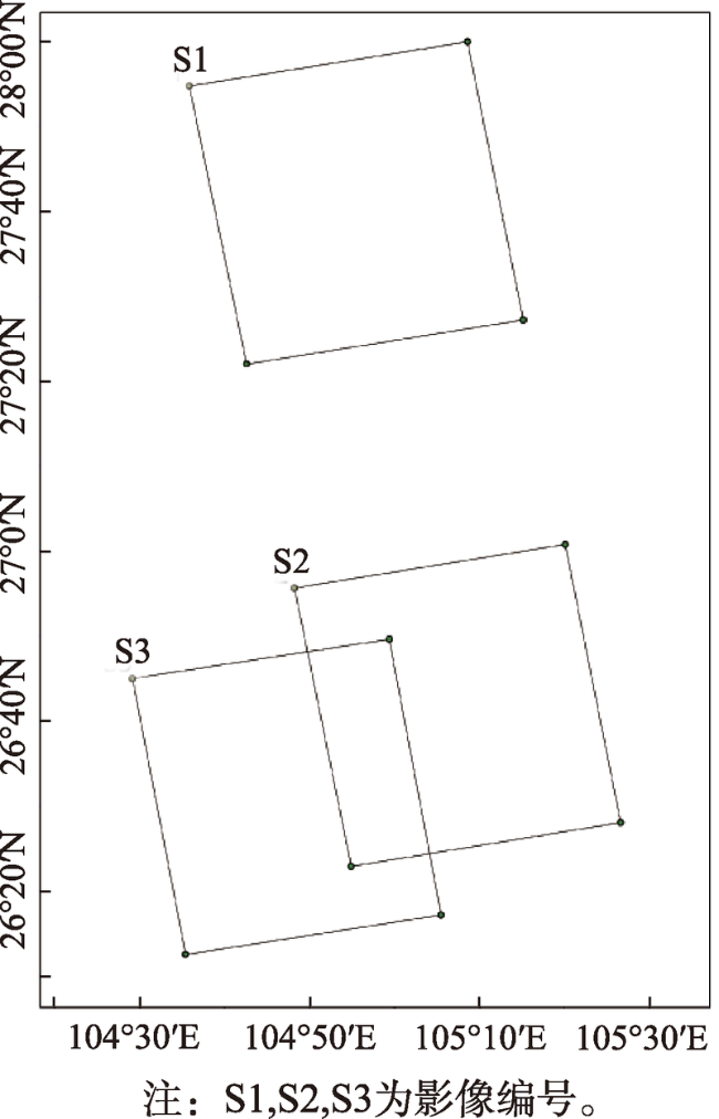
Fig. 2 The coverage area of experiment data图2 试验数据范围 |
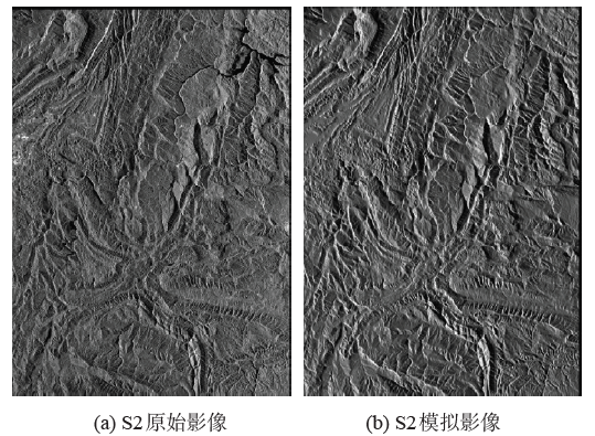
Fig. 3 Original SAR image and simulation SAR image of S2图3 S2原始SAR影像和模拟SAR影像 |
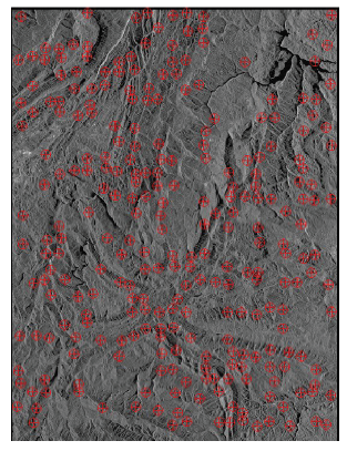
Fig. 4 Reference points of parameters correction on S2 image图4 S2影像上参数校正参考点分布 |
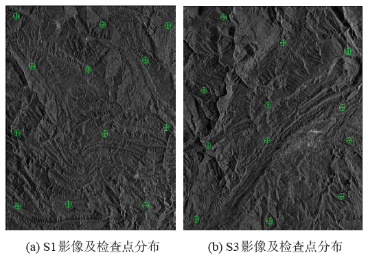
Fig. 5 S1 image, S3 image and their check points图5 S1影像和S3影像及检查点分布 |
Tab. 1 Geolocation error of S1 image before and after parameters correction表1 S1影像参数校正后前几何定位误差 |
| 点号 | 参数校正前 | 参数校正后 | |||
|---|---|---|---|---|---|
| 东方向 误差/m | 北方向 误差/m | 东方向 误差/m | 北方向 误差/m | ||
| 1 | 59.8 | -26.6 | -3.3 | -3.0 | |
| 2 | 72.6 | -13.9 | 11.1 | 9.9 | |
| 3 | 67.0 | -7.9 | 6.4 | 16.1 | |
| 4 | 57.2 | -24.5 | -3.6 | -0.5 | |
| 5 | 60.5 | -32.0 | -2.3 | -8.3 | |
| 6 | 60.0 | -16.5 | -1.7 | 7.3 | |
| 7 | 56.3 | -21.4 | -4.2 | 2.6 | |
| 8 | 57.5 | -32.9 | -5.6 | -9.2 | |
| 9 | 70.4 | -20.1 | 8.8 | 3.7 | |
| 10 | 67.4 | -31.1 | 4.2 | -7.4 | |
| 11 | 53.9 | -18.1 | -8.2 | 5.7 | |
| 12 | 53.5 | -22.4 | -7.3 | 1.67 | |
| 中误差 | 61.7 | 23.5 | 6.2 | 7.5 | |
Tab. 2 Geolocation error of S3 image before and after parameters correction表2 S3影像参数校正后前几何定位误差 |
| 点号 | 参数校正前 | 参数校正后 | |||
|---|---|---|---|---|---|
| 东方向 误差/m | 北方向 误差/m | 东方向 误差/m | 北方向 误差/m | ||
| 1 | 70.6 | -3.7 | 15.3 | 14.9 | |
| 2 | 61.5 | -8.3 | 6.8 | 10.4 | |
| 3 | 69.0 | -3.7 | 14.8 | 15.1 | |
| 4 | 62.4 | -8.3 | 6.9 | 10.3 | |
| 5 | 55.5 | -25.2 | 0.6 | -6.4 | |
| 6 | 55.6 | -12.3 | 1.4 | 6.4 | |
| 7 | 55.5 | -25.2 | 0.6 | -6.4 | |
| 8 | 61.3 | -11.3 | 7.2 | 7.4 | |
| 9 | 65.5 | -26.8 | 10.1 | -8.1 | |
| 10 | 61.6 | -30.3 | 7.4 | -11.5 | |
| 11 | 66.6 | -33.0 | 11.1 | -14.3 | |
| 12 | 52.5 | -25.7 | -2.2 | -6.9 | |
| 中误差 | 61.7 | 20.6 | 8.6 | 10.4 | |
The authors have declared that no competing interests exist.
| [1] |
[
|
| [2] |
|
| [3] |
[
|
| [4] |
[
|
| [5] |
[
|
| [6] |
[
|
| [7] |
岳昔娟.稀少(无)控制条件下机载SAR 高精度定位技术研究[D].武汉:武汉大学,2009.
[
|
| [8] |
[
|
| [9] |
[
|
| [10] |
[
|
| [11] |
[
|
| [12] |
[
|
| [13] |
[
|
| [14] |
[
|
| [15] |
|
| [16] |
|
| [17] |
[
|
| [18] |
[
|
| [19] |
[
|
| [20] |
[
|
| [21] |
[
|
/
| 〈 |
|
〉 |