
利用高精度DLG进行机载LiDAR点云精度评定研究
作者简介:陶鹏杰(1986-),男,湖北武穴人,博士,助理研究员,研究方向为数字摄影测量与遥感。E-mail:pjtao@whu.edu.cn
收稿日期: 2018-09-01
要求修回日期: 2019-01-11
网络出版日期: 2019-04-24
基金资助
国家重点研发计划项目(2017YFB0503004)
国家自然科学基金项目(41801390)
国土资源评价与利用湖南省重点实验室开放课题资助(SYS-MT-201802)
Accuracy Assessment of Airborne LiDAR Point Cloud Using High Precision DLG as Reference
Received date: 2018-09-01
Request revised date: 2019-01-11
Online published: 2019-04-24
Supported by
National Key Research and Development Program of China, No.2017YFB0503004
National Natural Science Foundation of China, No.41801390
Open Topic of the Hunan Key Laboratory of Land Resources Evaluation and Utilization, No.SYS-MT-201802
Copyright
LiDAR作为一种主动式获取高精度地表几何信息的地形图测绘技术,其获取的点云具有较高的相对精度与绝对精度,可作为无控或稀少控制条件下(无人机)航空影像高精度几何定位的地理参考数据。影像几何定位所能达到的精度依赖于几何参考数据自身的精度,因此评价LiDAR点云的精度对于将其作为地理参考实现航空影像高精度几何定位,具有较强的理论价值与实践意义。本文提出了利用高精度数字线划图(DLG)作为几何参考评定机载LiDAR点云精度的方法。首先,通过比对DLG中高程注记点的高程与LiDAR点云中对应位置处的高程,实现LiDAR点云高程精度评定;然后,通过统计LiDAR墙面点在平面上的投影点到DLG房屋矢量轮廓线的距离,实现LiDAR点云平面精度评定。实验结果证明,本文试验区域LiDAR点云平面和高程精度分别可达到7.2 cm和8.3 cm,可作为大比例尺无人机航空遥感控制数据的有效选择。
陶鹏杰 , 宋孟肖 , 段延松 . 利用高精度DLG进行机载LiDAR点云精度评定研究[J]. 地球信息科学学报, 2019 , 21(4) : 608 -614 . DOI: 10.12082/dqxxkx.2019.180425
LiDAR is an active topographic mapping technique for obtaining high precision surface geometric information. In recent years, LiDAR point cloud has been widely used and gradually become a new standard geospatial information product, because of its efficiency, directness and easy availability. Due to its high accuracy, LiDAR point cloud data can be used as georeference data for aerial triangulation of unmanned aerial vehicle (UAV) imagery with sparse ground control points (GCPs) or even without GCP. Because the accuracy of aerial triangulation strongly depends on the accuracy of georeference data itself, so it is of great practical significance to evaluate the accuracy of LiDAR point cloud as georeference data. In this study, we proposed a method for evaluating the accuracy of airborne LiDAR point cloud data using high precision digital line graphic (DLG) as reference data. This method realizes not only the assessment of the vertical accuracy of LiDAR point cloud, but also the reliable assessment of the horizontal accuracy of LiDAR point cloud. Firstly, the vertical accuracy was evaluated by comparing the elevations of the elevation points in DLG with the elevations of the LiDAR points at corresponding positions. Secondly, the facade points of LiDAR buildings were extracted and projected into a horizontal plane, and their distances from the outlines of buildings in DLG were calculated to evaluate the horizontal accuracy of LiDAR point cloud. Due to the existence of a large number of elevation points and building contours in the DLG, the accuracy assessment samples were abundant, and the assessment results could reflect the true accuracy level of LiDAR point cloud. The experiments showed that the horizontal and vertical accuracy of LiDAR point cloud in the test area could reach 7.2 cm and 8.3 cm, respectively, which proved that LiDAR can be used as an effective control data for large scale UAV aerial remote sensing purpose.
Tab. 1 Countries with national LiDAR datasets either completed or in progress表1 建设National LiDAR dataset的国家及其建设情况[8] |
| 编号 | 国家 | 数据集建设状态 | 点云密度/(pts/m2) |
|---|---|---|---|
| 1 | 加拿大 | 蒙特利尔已完成,2015年 | 10 |
| 2 | 丹麦 | 完成,2008年,2013年 | 4 |
| 3 | 芬兰 | 完成 | 0.5 |
| 4 | 拉脱维亚 | 正在建设,2013-2018年 | 4 |
| 5 | 荷兰 | 完成,2003年 | 1/25-1/16 (AHN1), 6-10 (AHN2) |
| 6 | 芬兰 | 正在建设 | 4~12 |
| 7 | 斯洛文尼亚 | 完成,2015年 | 5 |
| 8 | 西班牙 | 正在建设 | 0.5 |
| 9 | 瑞典 | 正在建设 | 0.5 |
| 10 | 瑞士 | 完成 | 1 |
| 11 | 美国 | 在讨论中 | |
| 12 | 英国 | 正在建设 | 0.5、1.0、4.0、16.0 |
| 13 | 新西兰 | 在讨论中 |
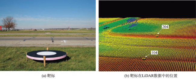
Fig. 1 Accuracy evaluation of LiDAR point cloud based on circular target图1 基于圆形靶标的LiDAR点云精度评价[20] |
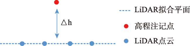
Fig. 2 Local elevation interpolation of LiDAR points图2 LiDAR点云拟合局部高程示意 |
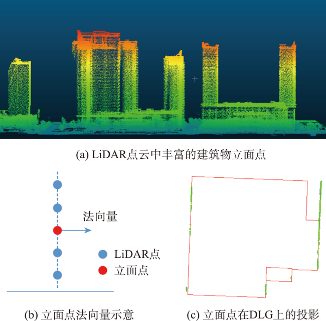
Fig. 3 Using horizontal distances from façade points to DLG to evaluate the horizontal accuracy of LiDAR point cloud图3 利用建筑物立面点到DLG的平面距离评价LiDAR点云平面精度 |
Fig. 4 Overview of LiDAR point cloud and distributions of control points and buildings in Ningbo test area图4 宁波测区LiDAR点云、控制点和建筑物分布概况 |
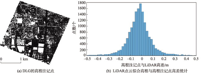
Fig. 5 Assessment results of vertical accuracy图5 LiDAR点云高程精度评价结果 |
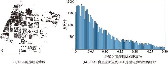
Fig. 6 Assessment results of horizontal accuracy图6 LiDAR点云平面精度评价结果 |
Tab. 2 Comparison of accuracy assessment results of LiDAR based on this method and ground control point method表2 本文方法与地面控制点方法的LiDAR点云精度评价结果对比 |
| 方法 | 点数 | LiDAR高程误差/cm | LiDAR平面误差/cm | |||||
|---|---|---|---|---|---|---|---|---|
| 中误差 | 最小值 | 最大值 | 中误差 | 最小值 | 最大值 | |||
| 本文基于DLG的方法 | 3030 | 8.3 | 0.1 | 48.5 | 7.2 | 0.3 | 29.8 | |
| 基于地面控制点的方法 | 34 | 13.2 | 0.2 | 35.6 | n/a | n/a | n/a | |
The authors have declared that no competing interests exist.
| [1] |
[
|
| [2] |
[
|
| [3] |
[
|
| [4] |
|
| [5] |
|
| [6] |
|
| [7] |
|
| [8] |
National lidar dataset[EB/OL]. [2018-09-01]
|
| [9] |
|
| [10] |
|
| [11] |
|
| [12] |
|
| [13] |
|
| [14] |
[
|
| [15] |
[
|
| [16] |
|
| [17] |
|
| [18] |
|
| [19] |
|
| [20] |
|
| [21] |
[
|
| [22] |
[
|
| [23] |
|
| [24] |
[
|
/
| 〈 |
|
〉 |
