
青藏高原城乡建设用地和生态用地转移时空格局
|
刘子川(1995-),女,内蒙古锡林浩特人,硕士生,主要从事遥感地学分析研究。E-mail: liuzc. 17s@igsnrr.ac.cn |
收稿日期: 2019-02-27
要求修回日期: 2019-04-23
网络出版日期: 2019-08-25
基金资助
中国科学院战略性先导科技专项(XDA20040401)
版权
Spatio-temporal Dynamics of the Urban-Rural Construction Land and Ecological Land on Qinghai-Tibet Plateau
Received date: 2019-02-27
Request revised date: 2019-04-23
Online published: 2019-08-25
Supported by
Supported by the Strategic Priority Research Program of Chinese Academy of Sciences(XDA20040401)
Copyright
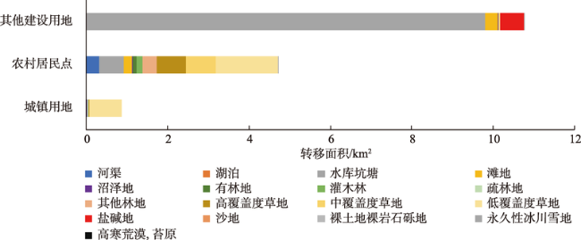
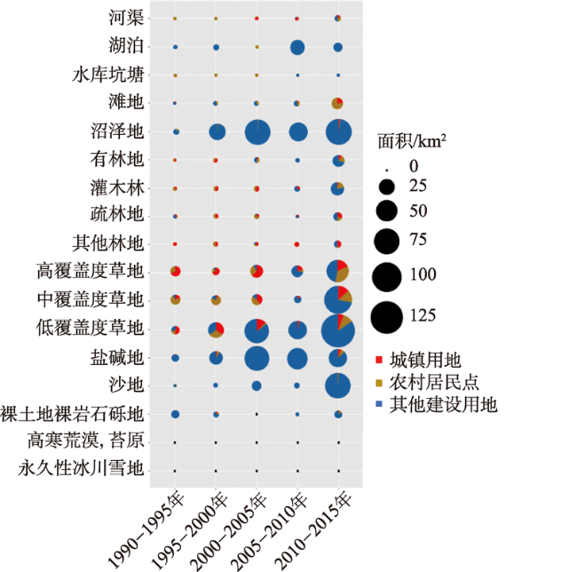
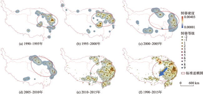
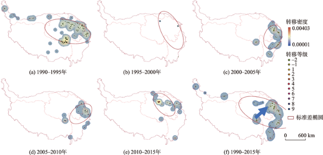
青藏高原作为中国重要的生态环境保护地,城镇化和生态环境的变化受到广泛关注。本文基于1990-2015年土地利用数据,进行生态用地和城乡建设用地之间的转移分析,通过核密度以及标准差椭圆分析进行空间转移强度的定性研究。结果表明:① 1990-2015年青藏高原生态用地显著地向城乡建设用地转移,是城乡建设用地向生态用地转移量的54.6倍,其中2000-2005年和2010-2015年是用地转移的热点时期;② 城乡建设用地与生态用地之间的转换在空间上呈现逆向状态,生态用地向城乡建设用地的转移分布逐渐从青藏高原的周边区域向腹地蔓延;城乡建设用地向生态用地的转移最初出现在青藏高原的腹地,逐渐向外围扩张;③ 生态服务功能越大的生态用地,越容易被人类占用,随之发生用地类型的转移,侵占后的土地很难反向转移为具有高生态服务功能的生态用地。
刘子川 , 冯险峰 , 武爽 , 孔玲玲 , 姚玄楚 . 青藏高原城乡建设用地和生态用地转移时空格局[J]. 地球信息科学学报, 2019 , 21(8) : 1207 -1217 . DOI: 10.12082/dqxxkx.2019.190087
:With the development of urbanization, more and more urban and rural construction land has been converted to ecological land on Qinghai-Tibet Plateau. Land use change is a key component for global environment change, it also reflects the impacts of human activities on the environment. To some extent, urban and rural construction land can represent the intensity of human activities. Based on the land use data of 1990, 2000, 2005, 2010, and 2015 on Qinghai-Tibet Plateau, the conversation of ecological land to urban and rural construction land in the past decades were analyzed by land-use conversion matrix. Using kernel density and standard deviational ellipse, the spatial mechanism of the conversion was analyzed. The results show that: (1) In the past 25 years, lots of ecological land have been converted to urban and rural construction land. It is over 50 times the conversation of urban and rural construction land to ecological land. The conversion concentrated in two periods, 2000-2005 and 2010-2015. (2) Through experiments, 10km grid can reflect the spatial distribution regularities more obviously. The conversion between urban and rural construction land and ecological land presented a spatial reverse. The conversion of ecological land to urban and rural construction land occurred in just marginal areas. As time went by, urban and rural construction land gradually invaded the hinterland of Qinghai-Tibet Plateau. On the contrary, the conservation of urban and rural construction land to ecological land appeared in the hinterland of Qinghai-Tibet Plateau, and it gradually spread outward. (3) The towns, the hot spots of land conversion, can be divided into four 4 types. Type one is provincial capitals, located in river valleys; type two is industrial towns; type three towns are always located in natural ecological protection areas; and type four is tourism towns with good natural environment and convenient transportation. (4) Ecological lands that have higher ecological services are more likely to be converted to urban and rural construction land more easily. Nevertheless, it is very difficult for urban and rural construction land to transfer to ecological land. Reverse conversion usually transfers from urban and rural construction land to some low ecological service land. In general, the area of urban and rural construction land has increased a lot during the 25 years. Because of the large area of ecological land, ecological land use dynamic index is very low. On Qinghai-Tibet Plateau urbanization did not have a negative effect on eco-environment. So sustainable urbanization is still a significant development trend on Qinghai-Tibet Plateau in the future.
表1 生态用地和城乡建设用地分类Tab. 1 Classification of ecological land and urban-rural construction land |
| 一级类 | 二级类 | ||
|---|---|---|---|
| 编码 | 名称 | 编码 | 名称 |
| 1 | 湿地 | 11 | 河渠 |
| 12 | 湖泊 | ||
| 13 | 水库坑塘 | ||
| 14 | 滩地 | ||
| 15 | 沼泽地 | ||
| 2 | 林地 | 21 | 有林地 |
| 22 | 灌木林 | ||
| 23 | 疏林地 | ||
| 24 | 其他林地 | ||
| 3 | 草地 | 31 | 高覆盖度草地 |
| 32 | 中覆盖度草地 | ||
| 33 | 低覆盖度草地 | ||
| 4 | 其他生态土地 | 41 | 盐碱地 |
| 42 | 沙地 | ||
| 43 | 裸土地 | ||
| 44 | 裸岩石砾地 | ||
| 45 | 荒漠、苔原 | ||
| 46 | 永久性冰川雪地 | ||
| 5 | 城乡、工矿、居民用地 | 51 | 城镇用地 |
| 52 | 农村居民点 | ||
| 53 | 其他建设用地 | ||
| 0 | 其他用地 | ||
表2 城乡建设用地和生态用地转移等级划分Tab. 2 Conversion level divisions of ecological land and urban-rural construction land (%) |
| 等级 | ||||||||||||
|---|---|---|---|---|---|---|---|---|---|---|---|---|
| 9 | 8 | 7 | 6 | 5 | 4 | 3 | 2 | 1 | 0 | -1 | -2 | |
| D | 44.7~50.3 | 39.1~44.7 | 33.5~39.1 | 28.0~33.5 | 22.4~28.0 | 16.8~22.4 | 11.2~16.8 | 5.6~11.2 | 0~5.6 | 0 | -5.6~0 | -5.6~-8.7 |
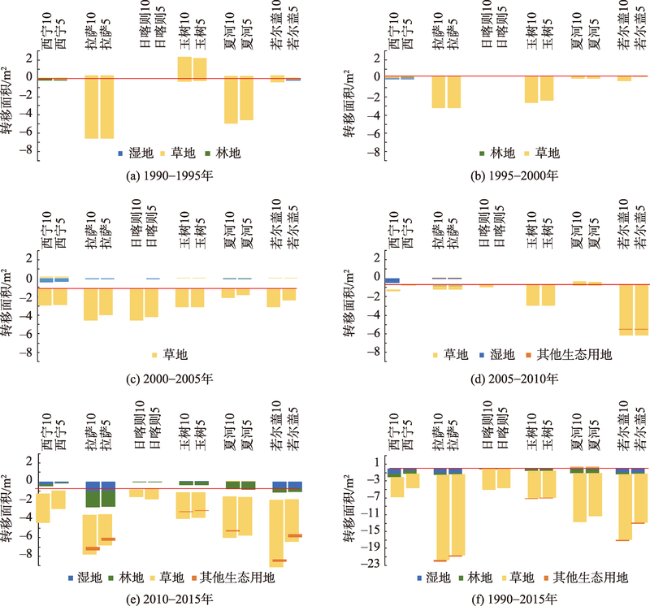
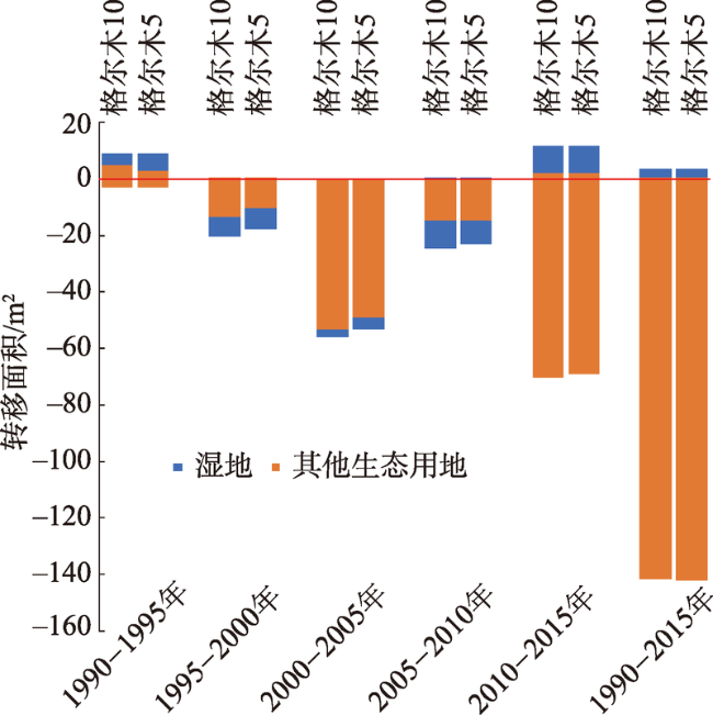
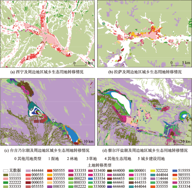
图5 青藏高原重点城镇5 km、10 km缓冲区内用地转移情况注:0刻度线上方是指城乡建设用地向不同类型生态用地的转移情况,下方是指不同类型的生态用地向城乡建设用地的转移情况。图中重点城镇后的数字代表缓冲区范围。 Fig. 5 Conversion in 5km and 10 km buffers of some important towns on Qinghai-Tibet Plateau |
| [1] |
孙鸿烈, 郑度, 姚檀栋 , 等. 青藏高原国家生态安全屏障保护与建设[J]. 地理学报, 2012,67(1):3-12.
[
|
| [2] |
|
| [3] |
谢高地, 鲁春霞, 冷允法 , 等. 青藏高原生态资产的价值评估[J]. 自然资源学报, 2003,18(2):189-196.
[
|
| [4] |
|
| [5] |
傅小锋 . 青藏高原城镇化及其动力机制分析[J]. 自然资源学报, 2000,15(4):369-374.
[
|
| [6] |
张荣天, 焦华富 . 中国省际城镇化与生态环境的耦合协调与优化探讨[J]. 干旱区资源与环境, 2015,29(7):12-17.
[
|
| [7] |
韩会然, 杨成凤, 宋金平 . 北京市土地利用变化特征及驱动机制[J]. 经济地理, 2015,35(5):148-154.
[
|
| [8] |
|
| [9] |
|
| [10] |
冯仕超, 高小红, 亢健 , 等. 西宁市30多年来土地利用/土地覆被变化及城市扩展研究[J]. 干旱区研究, 2012,29(1):129-136.
[
|
| [11] |
除多, 张镱锂, 郑度 . 拉萨地区土地利用变化[J]. 地理学报, 2006,61(10):1075-1083.
[
|
| [12] |
李小雁, 许何也, 马育军 , 等. 青海湖流域土地利用/覆被变化研究[J]. 自然资源学报, 2008,23(2):285-296.
[
|
| [13] |
张镱锂, 刘林山, 摆万奇 , 等. 青藏公路对区域土地利用和景观格局的影响——以格尔木至唐古拉山段为例[J]. 地理学报, 2002,57(3):253-266.
[
|
| [14] |
吴致蕾, 刘峰贵, 张镱锂 , 等. 清代青藏高原东北部河湟谷地林草地覆盖变化[J]. 地理科学进展, 2016,35(6):768-778.
[
|
| [15] |
李士成, 张镱锂, 何凡能 . 过去百年青海和西藏耕地空间格局重建及其时空变化[J]. 地理科学进展, 2015,34(2):197-206.
[
|
| [16] |
张明 . 以土地利用/土地覆被变化为中心的土地科学研究进展[J]. 地理科学进展, 2001,20(4):297-304.
[
|
| [17] |
陈百明, 张凤荣 . 我国土地利用研究的发展态势与重点领域[J]. 地理研究, 2011,30(1):1-9.
[
|
| [18] |
钟凯文, 孙彩歌, 解靓 , 等. 基于GIS的广州市土地利用遥感动态监测与变化分析[J]. 地球信息科学学报, 2009,11(1):111-116.
[
|
| [19] |
雷军成, 王莎, 汪金梅 , 等. 土地利用变化对寻乌县生态系统服务价值的影响[J]. 生态学报, 2019,39(9):3089-3099.
[
|
| [20] |
张映雪, 莫文波, 王勇 , 等. 北京市高速公路周边土地利用变化对景观格局的影响[J]. 地球信息科学学报, 2017,19(1):28-38.
[
|
| [21] |
刘睿, 周李磊, 彭瑶 , 等. 三峡库区重庆段人类活动时空分布及其类型演变特征[J]. 重庆师范大学学报(自然科学版), 2016,33(4):47-56,230.
[
|
| [22] |
董雅文, 周雯, 周岚 , 等. 城市化地区生态防护研究——以江苏省、南京市为例[J].城市研究, 1999(2):6-8.
[
|
| [23] |
韩学敏, 濮励杰, 朱明 , 等. 环太湖地区有效生态用地面积的测算分析[J]. 中国农学通报, 2010,26(22):301-305.
[
|
| [24] |
陈婧, 史培军 . 土地利用功能分类探讨[J]. 北京师范大学学报(自然科学版), 2005,41(5):536-540.
[
|
| [25] |
邓红兵, 陈春娣, 刘昕 , 等. 区域生态用地的概念及分类[J]. 生态学报, 2008,29(3):1519-1524.
[
|
| [26] |
俞孔坚, 乔青, 李迪华 , 等. 基于景观安全格局分析的生态用地研究——以北京市东三乡为例[J].应用生态学报, 2009(8):1932-1939.
[
|
| [27] |
刘纪远, 匡文慧, 张增祥 , 等. 20世纪80年代末以来中国土地利用变化的基本特征与空间格局[J]. 地理学报, 2014,69(1):3-14.
[
|
| [28] |
刘纪远, 宁佳, 匡文慧 , 等. 2010-2015年中国土地利用变化的时空格局与新特征[J]. 地理学报, 2018,73(5):789-802.
[
|
| [29] |
喻锋, 李晓波, 张丽君 , 等. 中国生态用地研究:内涵、分类与时空格局[J]. 生态学报, 2015,35(14):4931-4943.
[
|
| [30] |
王秀兰, 包玉海 . 土地利用动态变化研究方法探讨[J]. 地理科学进展, 1999,18(1):81-87.
[
|
| [31] |
黄聪, 赵小敏, 郭熙 , 等. 基于核密度的余江县农村居民点布局优化研究[J]. 中国农业大学学报, 2016,21(11):165-174.
[
|
| [32] |
熊俊楠, 赵云亮, 程维明 , 等. 四川省山洪灾害时空分布规律及其影响因素研究[J]. 地球信息科学学报, 2018,20(10):1443-1456.
[
|
| [33] |
赵媛, 杨足膺, 郝丽莎 , 等. 中国石油资源流动源—汇系统空间格局特征[J]. 地理学报, 2012,67(4):455-466.
[
|
| [34] |
华人民共和国自然保护区条例[R]. 中华人民共和国国务院公报, 1994: 5-8.
[ Bulletin of the State Council of the People's Republic ofegulations of the People's Republic of China on Natural Reserves [R] Bulletin of the State Council of the People's Republic of China, 1994: 5-8. ]
|
| [35] |
肖景义, 曹广超, 侯光良 . 青藏高原地质公园生态旅游产品开发研究——以坎布拉国家地质公园为例[J]. 地球学报, 2011,32(2):225-232.
[
|
| [36] |
李佳鸣, 冯长春 . 基于土地利用变化的生态系统服务价值及其改善效果研究——以内蒙古自治区为例[J/OL]. 生态学报, 2019,39(13):1-9.
[
|
/
| 〈 |
|
〉 |