
基于垂直带谱的太白山区山地植被遥感信息提取
|
张俊瑶(1995-),女,山东滨州人,硕士生,研究方向为植被遥感分类。E-mail: eaea330@163.com |
收稿日期: 2018-12-12
要求修回日期: 2019-04-09
网络出版日期: 2019-08-25
基金资助
国家自然科学基金项目(41871350)
科技基础资源调查项目(2017FY100900)
版权
Mapping of Mountain Vegetation in Taibai Mountain based on Mountain Altitudinal Belts with Remote Sensing
Received date: 2018-12-12
Request revised date: 2019-04-09
Online published: 2019-08-25
Supported by
National Natural Science Foundation of China(41871350)
Scientific and Technological Basic Resources Survey Project(2017FY100900)
Copyright
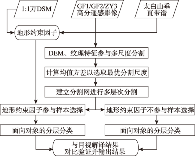
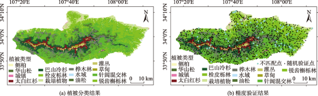
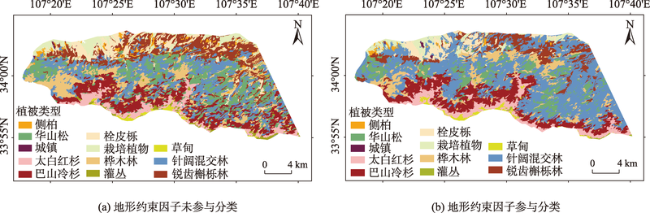
遥感数据因其全覆盖的优势被广泛应用于山地植被信息的调查和研究。为了实现山区植被类型的高精度提取,本文以太白山区为实验区,结合山地植被的垂直地带性分布规律,利用太白山植被垂直带谱、高分辨率遥感影像(GF1/GF2/ZY3)和1:1万的数字表面模型(Digital Surface Model, DSM)数据,进行了多层次、多尺度的影像分割,构建了具有植被垂直带谱信息的地形约束因子,并据此进行样本选择和面向对象的分类,分类总精度达92.9%,kappa系数达到0.9160。该方法相比于未辅以垂直带谱信息的分类,总精度提高了10%。研究结果表明,分类过程中加入具有垂直带谱信息的地形约束因子,能显著地提高样本选择的效率和准确率,为后续的植被分类提供了精度的保证。通过人机交互的方式,将垂直带谱知识应用到分类中,可以有效地提高山地植被分类的精度。
张俊瑶 , 姚永慧 , 索南东主 , 郜丽静 , 王晶 , 张兴航 . 基于垂直带谱的太白山区山地植被遥感信息提取[J]. 地球信息科学学报, 2019 , 21(8) : 1284 -1294 . DOI: 10.12082/dqxxkx.2019.180650
The structural function and ecological characteristics of mountain vegetation can reflect comprehe-nsively the basic characteristics and functional properties of the eco-environment. Mapping of different vegetation types is the basis for the study of vegetation cover dynamics. Therefore, studying vegetation types and their distribution patterns in montane areas is important for understanding the eco-environment and climatic spatial changes. With the development and application of satellite remote sensing technology, remote sensing data have been widely used in the investigation and research of mountain vegetation information extraction. As altitude increases, vegetation presents the characteristic of regular zonal arrangement and combination, which is called the altitudinal belts law of mountain vegetation. Through the altitudinal vegetation belts information, the altitude range of different vegetation groups and the adjacent relationship between the upper and lower layers can be determined. To achieve high-precision extraction of mountain vegetation types, in this paper, we took Taibai Mountain (the main peak of Qinling Mountains) as the experimental area, combined the obvious vertical zonal distribution law of mountain vegetation, and used the data of altitudinal belts of Taibai Mountain vegetation, high-resolution remote sensing imagery (GF1/GF2/ZY3), and 1:10 000 digital surface model (DSM). Followingly, we selected the optimal segmentation scale of different levels by calculating the mean variance, and conducted multi-level and multi-scale image segmentation. Then, we built terrain constraint factors with mountain altitudinal belts information and selected samples. After overlaying terrain constraint factors with altitudinal belts information of vegetation on the high-resolution images, the rough distribution ranges of each vegetation types were clear at a glance, which can make sample selection more efficient and accurate. Lastly, the images were used to extract vegetation information through the object-oriented classification method. The classification result had a total accuracy of 92.9% and a kappa coefficient of 0.9160. To prove the role of terrain constraint factors, some regions in the western part of the north slope were selected for comparing whether terrain constraint factors affected the classification. Compared with the classification without altitudinal vegetation belts information, this method improved the overall accuracy by 10%. The results show that adding terrain constraint factors in the classification process can significantly improve the efficiency and accuracy of sample selection, and provide a guarantee for the accuracy of subsequent vegetation classification. By man-machine interaction, this study applies the knowledge of mountain altitudinal belts to classification, and effectively improves the accuracy of mountain vegetation classification.
表1 遥感卫星影像的时相及空间分辨率信息Tab. 1 Phase and spatial resolution of the remote sensing images |
| 遥感影像 | 传感器 | 融合后分辨率/m | 成像时间 | 融合后波段数/个 |
|---|---|---|---|---|
| GF2 | PMS | 0.8 | 2017-09-07 | 4 |
| ZY3 | NAD | 2 | 2017-01-13 | 4 |
| GF1 | PMS | 2 | 2016-11-30/2017-02-12 | 4 |
| GF1 | WFV | 16 | 2017-01-02/2017-07-09 | 4 |
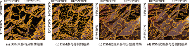
表2 多尺度分割参数设置Tab. 2 Parameter setting for the multi-scale segmentation |
| 等级 | 提取信息 | 分割尺度 | 形状因子 | 紧致度因子 |
|---|---|---|---|---|
| Level1 | 建筑物、道路等非植被 | 470 | 0.2 | 0.6 |
| Level2 | 栽培植物、针叶林、阔叶林、亚高山草甸及灌丛、针阔混交林 | 360 | 0.2 | 0.6 |
| Level3 | 巴山冷杉、太白红杉、华山松、栎类林、桦类林、草甸、灌丛 | 250 | 0.2 | 0.6 |
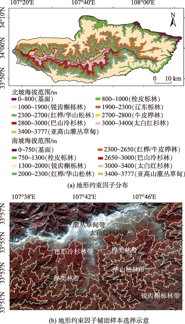
图3 太白山区基于地形约束因子的样本选择Fig. 3 Sample selection based on terrain constraint factors in Taibai Mountain |
Tab. 3 Classification rules of surface features at different levels |
| 层次 | 类别 | 分类方法 | 特征 | 隶属度函数 | 特征值范围 |
|---|---|---|---|---|---|
| Level1 | 非植被 | 模糊分类 | Max.diff |  | 5.9, 6.0 |
| DSM |  | 1890, 1900 | |||
| DSM |  | 1340, 1350 | |||
| NDVI×100 |  | -2, -1 | |||
| 植被 | Not 非植被 | ||||
| Level2 | 栽培植物、针叶林、阔叶林、亚高山草甸及灌丛、针阔混交林 | 最近邻分类 | Brightness\Mean DSM\Mean NIR\Max.diff | - | - |
| Level3 | 巴山冷杉、太白红杉、华山松、栎林、桦类林、灌丛、草甸 | 最近邻分类 | Brightness\Mean DSM\Mean NIR\ GLCM Contrast\GLCM Homogeneity | - | - |
表4 太白山区不同土地覆盖类别的解译标志Tab. 4 Interpretation signs of different land cover types in Taibai Mountain |
| 序号 | 土地覆盖类别 | 解译特征 | 影像示例 | 影像月份 |
|---|---|---|---|---|
| 1 | 非植被 | 形状规则,片状分布,色调呈灰白色(假彩色),集中分布在基带附近,边界清晰 |  | 1月 |
| 2 | 栽培植物 | 形状较规则,片状分布,色调呈暗棕色夹杂淡红色(假彩色),集中分布在基带附近,边界清晰 |  | 1月 |
| 3 | 栎类林 | 形状不规则,带状分布,色调呈绿色(真彩色),集中分布在低海拔区域,边界模糊 |  | 10月 |
| 4 | 桦类林 | 形状不规则,带状分布,色调成黄绿色(真彩色),分布在栎类林海拔之上,纹理细腻,边界模糊 |  | 10月 |
| 5 | 针阔混交林 | 形状不规则,带状分布,色调呈灰棕色夹杂红色(假彩色),分布在桦林和华山松林海拔之间,边界模糊 |  | 1月 |
| 6 | 华山松 | 形状不规则,带状分布,色调呈鲜红色(假彩色),分布在中海拔区域,纹理细腻,边界模糊 |  | 1月 |
| 7 | 巴山冷杉 | 形状不规则,带状分布,色调呈深红色(假彩色),分布在华山松海拔之上,绒状纹理,边界模糊 |  | 1月 |
| 8 | 太白红杉 | 形状不规则,带状分布,色调呈深灰色(假彩色),分布在高海拔区域,纹理粗糙,边界模糊 |  | 1月 |
| 9 | 灌丛 | 形状不规则,块状分布,色调呈米白色夹杂深绿色(真彩色),集中分布在高海拔区域,边界清晰 |  | 7月 |
| 10 | 草甸 | 形状不规则,块状分布,色调呈草绿色(真彩色),集中分布在高海拔区域,边界模糊 |  | 7月 |
表5 植被分类的精度评价Tab. 5 Vegetation classification accuracy evaluation |
| 类别 | 太白 红杉 | 巴山 冷杉 | 华山松 | 桦类林 | 栓皮栎 | 锐齿 槲栎 | 针阔 混交 | 灌丛 | 草甸 | 城镇 道路 | 栽培 植物 | 总计 | 用户 精度/% |
|---|---|---|---|---|---|---|---|---|---|---|---|---|---|
| 太白红杉 | 30 | 2 | 0 | 0 | 0 | 0 | 0 | 0 | 0 | 0 | 0 | 32 | 93.8 |
| 巴山冷杉 | 0 | 98 | 0 | 0 | 0 | 0 | 2 | 0 | 0 | 0 | 0 | 100 | 98.0 |
| 华山松 | 0 | 2 | 158 | 0 | 0 | 0 | 0 | 0 | 0 | 1 | 0 | 161 | 98.1 |
| 桦类林 | 0 | 2 | 2 | 81 | 0 | 0 | 3 | 0 | 0 | 0 | 0 | 88 | 92.0 |
| 栓皮栎 | 0 | 0 | 1 | 0 | 70 | 17 | 3 | 0 | 0 | 0 | 0 | 91 | 76.9 |
| 锐齿槲栎 | 0 | 0 | 7 | 0 | 13 | 195 | 4 | 0 | 0 | 0 | 0 | 219 | 89.0 |
| 针阔混交 | 0 | 4 | 3 | 0 | 0 | 1 | 213 | 0 | 0 | 1 | 0 | 222 | 95.9 |
| 灌丛 | 1 | 0 | 1 | 0 | 0 | 0 | 0 | 18 | 0 | 0 | 0 | 20 | 90.0 |
| 草甸 | 0 | 0 | 0 | 0 | 0 | 0 | 0 | 0 | 8 | 0 | 0 | 8 | 100.0 |
| 城镇道路 | 0 | 0 | 0 | 0 | 0 | 0 | 0 | 0 | 0 | 4 | 0 | 4 | 100.0 |
| 栽培植物 | 0 | 0 | 0 | 0 | 0 | 0 | 1 | 0 | 0 | 0 | 54 | 55 | 98.2 |
| 总计 | 31 | 108 | 172 | 81 | 83 | 213 | 226 | 18 | 8 | 6 | 54 | 1000 | |
| 生产者精度/% | 96.8 | 90.7 | 91.9 | 100.0 | 84.3 | 91.5 | 94.2 | 100.0 | 100.0 | 66.7 | 100.0 |
注:总体分类精度(Overall accuracy):92.9%;kappa系数(kappa coefficient):0.9160。 |
| [1] |
梅安新 . 遥感导论[M]. 北京: 高等教育出版社, 2001.
[
|
| [2] |
朱晓勤, 刘康, 李建国 , 等. GIS支持下的秦岭山地植被分布与环境梯度关系研究[J]. 水土保持研究, 2009,16(2):169-175.
[
|
| [3] |
郭航, 张晓丽 . 基于遥感技术的植被分类研究现状与发展趋势[J]. 世界林业研究, 2007,20(3):14-19.
[
|
| [4] |
卢茂芬 . 遥感影像植被分类技术研究[D]. 郑州:解放军信息工程大学, 2012.
[
|
| [5] |
李伟涛 . 高分辨率遥感森林植被分类提取研究[D]. 北京:北京林业大学, 2016.
[
|
| [6] |
|
| [7] |
张嵩, 马保东, 陈玉腾 , 等. 融合遥感影像光谱和纹理特征的矿区林地信息变化监测[J]. 地理与地理信息科学, 2017,33(6):48-53.
[
|
| [8] |
张春华, 李修楠, 吴孟泉 , 等. 基于Landsat 8 OLI数据与面向对象分类的昆嵛山地区土地覆盖信息提取[J]. 地理科学, 2018,38(11):1904-1913.
[
|
| [9] |
|
| [10] |
|
| [11] |
|
| [12] |
陈波, 胡玉福, 喻攀 , 等. 基于纹理和地形辅助的山区土地利用信息提取研究[J]. 地理与地理信息科学, 2017,33(1):1-7.
[
|
| [13] |
赵英时 . 遥感应用分析原理与方法[M]. 北京: 科学出版社, 2013.
[
|
| [14] |
齐文娟, 杨晓梅 . 江西省都昌县山地与平原植被界线提取[J]. 地球信息科学学报, 2017,19(4):127-137.
[
|
| [15] |
何鸿杰, 穆亚超, 魏宝成 , 等. 分层分类和多指标结合的西北农牧交错带植被信息提取[J]. 干旱区地理, 2019,42(2):332-340.
[
|
| [16] |
|
| [17] |
中华人民共和国国家标准. GB/T 21010-2007,土地利用现状分类 [S].北京: 中国标准出版社,2007.
[ National Standards of the People's Republic of China.GB/T 21010-2007,Current Land Use Condition Classification[S]. Beijing: Standards Press of China, 2007.
|
| [18] |
陶欢, 李存军, 周静平 , 等. 基于高分1号影像的森林植被信息提取[J]. 自然资源学报, 2018,33(6):1068-1079.
[
|
| [19] |
冀欣阳, 骆磊, 王心源 , 等. 基于“DEM-NDVI-土地覆盖分类”的天山博格达自然遗产地山地垂直带提取与变化分析[J]. 地球信息科学学报, 2018,20(9):1350-1360.
[
|
| [20] |
孙然好, 张百平, 许娟 . 基于多源信息的区域尺度山地植被带数字化提取[J]. 山地学报, 2011,29(5):566-574.
[
|
| [21] |
陈煜, 许金石, 张丽霞 , 等. 太白山森林群落和林下草本物种变化的环境解释[J]. 西北植物学报, 2016,36(4):784-795.
[
|
| [22] |
吕宁, 吴逊涛, 康冰 , 等. 太白山自然保护区太白红杉天然林群落物种多样性动态监测[J]. 宁夏农林科技, 2017,58(8):19-22.
[
|
| [23] |
任学敏, 杨改河, 朱雅 , 等. 环境因子对太白山高山植被物种组成和丰富度的影响[J]. 生态学报, 2014,34(23):6993-7003.
[
|
| [24] |
张宏, 金学林, 李智军 . 陕西太白山自然保护区卫星遥感影像植被解译[J].陕西林业科技, 2011(2):44-46.
[
|
| [25] |
方正, 高淑贞 . 秦岭太白山南北坡的植被垂直带谱[J].植物生态学报, 1963(z1):164-165.
[
|
| [26] |
陕西师范大学. 西安市地理志[M]. 西安: 陕西人民出版社, 1988.
[
|
| [27] |
尚升海, 邢海虹 . 秦岭南北坡植被垂直分布的差异比较[J]. 吉林农业, 2016(1):114-115.
[
|
| [28] |
傅志军, 郭俊理 . 秦岭太白山植被的群落特征[J].宝鸡师范学院学报:自然科学版, 1992(1):70-75.
[
|
| [29] |
中国科学院中国植被图编辑委员会. 1:1 000 000中国植被图集[M]. 北京: 科学出版社, 2000.
[ Chinese vegetation map editing committee,
|
| [30] |
李海宁 . 太白山北坡植物物种多样性及其垂直分布格局研究[D]. 西安:陕西师范大学, 2007.
[
|
| [31] |
姚永慧, 张俊瑶, 索南东主 . 基于垂直带谱的南北过渡带1:5万植被类型图遥感制图研究——以太白山为例[J].地理学报,已接收. DOI: 10.11821/dlxb201909???.
[
|
| [32] |
|
| [33] |
周成虎, 骆剑承 , 等. 高分辨率卫星遥感影像地学计算[M]. 北京: 科学出版社, 2009.
[
|
| [34] |
陈春雷, 武刚 . 面向对象的遥感影像最优分割尺度评价[J]. 遥感技术与应用, 2011,26(1):96-102.
[
|
| [35] |
|
| [36] |
黄慧萍, 吴炳方 . 地物提取的多尺度特征遥感应用分析[J]. 遥感技术与应用, 2003,18(5):8-13.
[
|
/
| 〈 |
|
〉 |