
基于无人机影像和面向对象随机森林算法的岩溶湿地植被识别方法研究
|
耿仁方(1996-),男,山东梁山人,硕士生,主要从事环境遥感方面的研究。E-mail: gut_gis2015_grf@163.com |
收稿日期: 2018-12-05
要求修回日期: 2019-03-20
网络出版日期: 2019-08-25
基金资助
国家自然科学基金项目(41801071)
广西自然科学基金项目(2018GXNSFBA281015)
桂林理工大学科研启动基金资助项目(GUTQDJJ2017096)
广西八桂学者专项经费资助()
Object-Based Karst Wetland Vegetation Classification Method Using Unmanned Aerial Vehicle images and Random Forest Algorithm
Received date: 2018-12-05
Request revised date: 2019-03-20
Online published: 2019-08-25
Supported by
National Natural Science Foundation of China, No.41801071(41801071)
Guangxi Natural Science Foundation of China, No.2018GXNSFBA281015(2018GXNSFBA281015)
Guilin University of Technology research Foundation of China, No.GUTQDJJ2017096(GUTQDJJ2017096)
Guangxi Bagui Scholars" Foundation Support"()
Copyright
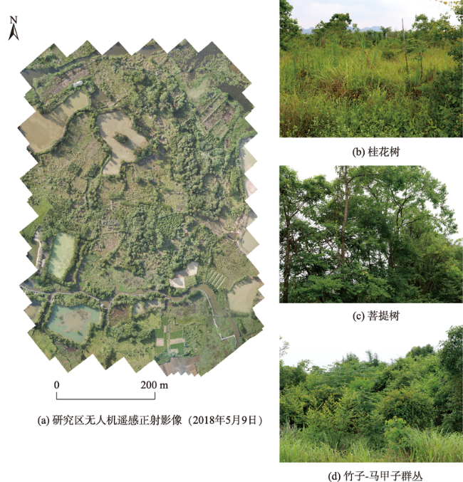
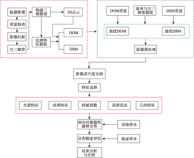
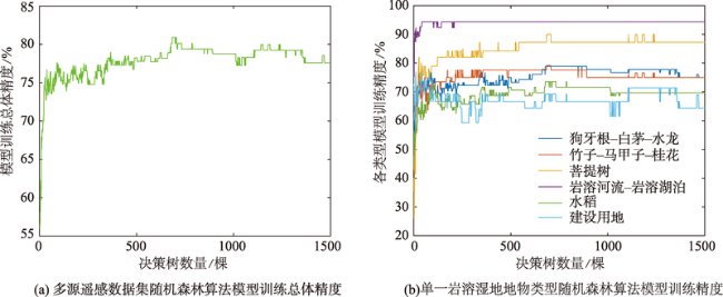
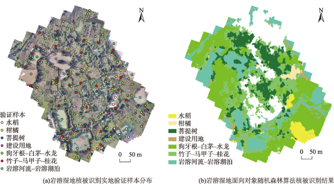
目前对岩溶湿地的重视程度远低于其他湿地类型,缺乏利用遥感技术进行岩溶湿地植被高精度识别的研究,但岩溶湿地同其他湿地类型一样,湿地面积退化严重,亟待需要解决。因此,本文选取受人类活动影响较大、湿地退化较为严重的广西桂林会仙喀斯特国家湿地公园的部分核心区域作为研究区,以DJI大疆御Mavic Pro无人机航摄影像为数据源,利用泛化能力强、分类精度高的面向对象随机森林算法实现了会仙岩溶湿地植被的高精度分类,探究无人机可见光影像和面向对象随机森林算法在岩溶湿地植被识别中的适用性,为无人机遥感技术应用于岩溶湿地的研究和保护提供技术参考。首先,在eCognition Developer9.0中利用多尺度迭代分割算法对影像图层进行分割;然后,基于以往在进行面向对象分类研究的经验来指导我们进行特征选择,充分考虑了影像的光谱和纹理特征、植被指数、无人机遥感数据派生的研究区数字地表模型(DSM)和几何特征;最后,在RStudio中实现了随机森林算法参数的调优、模型的构建以及分类。结果显示,面向对象随机森林算法对会仙湿地植被具有较高的识别能力,在95%置信区间内总体精度为86.75%,Kappa系数为0.83。在单一典型岩溶湿地植被识别精度中,狗牙根-白茅-水龙植被群丛的用户精度在90%以上,生产者精度高于80%,竹子-马甲子-桂花生产者精度高于80%,但是用户精度较低,仅为70.59%。
耿仁方 , 付波霖 , 蔡江涛 , 陈晓雨 , 蓝斐芜 , 余杭洺 , 李青逊 . 基于无人机影像和面向对象随机森林算法的岩溶湿地植被识别方法研究[J]. 地球信息科学学报, 2019 , 21(8) : 1295 -1306 . DOI: 10.12082/dqxxkx.2019.180631
Wetlands are among the most important ecosystems on Earth. They play a key role in alleviating floods and filtering polluted water, and also provide habitats for many plants and animals. A unique wetland type, karst wetland, is widely distributed in southwest China, as influenced by the special soil and water structure of karst landforms. Currently, domestic and foreign scholars pay much less attention to karst wetland than other wetland types, and lack targeted research on high-precision vegetation identification of karst wetland using remote sensing technology. However, like other wetland types, karst wetland has seriously degraded, and many problems need to be solved urgently. Huixian National Wetland Park, located in Guilin, Guangxi province, is a typical karst wetland. In this paper, part of the core area of the Huixian National Wetland Park was selected as the study area, which is greatly affected by human activities and severely degraded. The aerial photography images from an unmanned aerial vehicle (UAV) were used as the data source, and the object-based random forest algorithm was used to realize the high-precision classification of karst wetland vegetation. In so doing, we explored the applicability of UAV RGB remote sensing image and object-based random forest algorithm in karst wetland vegetation recognition, and provided a technical reference for the research and protection of karst wetland by using UAV remote sensing technology. First, the multiscale iterative segmentation algorithm was used to segment the image layers in eCognition Developer 9.0. Then, the texture features calculated based on the grey level co-occurrence matrix (GLCM) and spectral features of the images, the vegetation indexes, geometric features, and the elevation information (DSM) derived from the UAV remote sensing data were fully considered in the feature selection. Finally, the tuning of random forest algorithm parameters, model construction, and classification were implemented in RStudio. Results showed that the object-based random forest algorithm had a high recognition ability for the Huixian wetland vegetation. The overall accuracy was 86.75% and the Kappa coefficient was 0.83 in the 95% confidence interval. In the identification accuracy of vegetation in a single typical karst wetland, the user accuracy of the vegetation cluster of Bermudagrass-Cogongrass-Ludwigia was above 90%, the producer accuracy was over 80%. And the producer accuracy of the Bamboo-Thorny Wingnic-Sweet Olive was higher than 80%, but its user accuracy was only 70.59%.
表1 研究区训练和验证样本数据 |
| 类型 | 岩溶河流-岩溶湖泊 | 狗牙根-白茅-水龙 | 水稻 | 竹子-马甲子-桂花 | 菩提树 | 柑橘 | 建设用地 | 总计 |
|---|---|---|---|---|---|---|---|---|
| 训练样本 | 26 | 36 | 34 | 23 | 20 | 7 | 14 | 160 |
| 验证样本 | 39 | 47 | 6 | 29 | 28 | 3 | 14 | 166 |
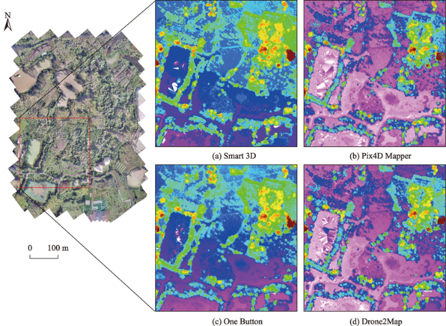
表2 四款无人机影像处理软件的影像处理统计结果对比Tab. 2 Comparison of image processing statistical results of four kinds of UAV image processing software (Smart 3D、Pix4D Mapper、Drone2Map、One Button) |
| 处理时间 | 空三误差/像元 | |
|---|---|---|
| Smart 3D | 5h:10m:8s | 0.72 |
| Pix4D Mapper | 1h:20m:57s | 0.43 |
| Drone2Map | 1h:31m:9s | 0.24 |
| One Button | 3h:56m:58s | - |
表3 影像分割参数优化训练初始值设定Tab. 3 Initial parameter setting of image segmentation during optimization training |
| 参数 | 精细尺度 | 中等尺度 | 大尺度 |
|---|---|---|---|
| 初始值 | 13 | 26 | 37 |
| 步长 | 10 | 30 | 50 |
| 迭代次数 | 100 | 100 | 100 |
| Shape | 0.7 | 0.7 | 0.7 |
| Compactness | 0.5 | 0.5 | 0.5 |
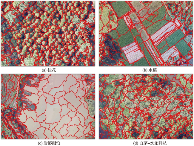
表4 岩溶湿地各地物面积统计Tab. 4 Area statistics of the various types of karst wetland |
| 类别 | 面积/hm2 | 比重/% |
|---|---|---|
| 水稻 | 0.91 | 3 |
| 柑橘 | 0.37 | 1 |
| 菩提树 | 3.74 | 13 |
| 建设用地 | 0.31 | 1 |
| 狗牙根-白茅-水龙 | 12.84 | 45 |
| 竹子-马甲子-桂花 | 5.66 | 20 |
| 岩溶河流-岩溶湖泊 | 4.84 | 17 |
表5 岩溶湿地地物总体分类精度Tab. 5 Overall classification accuracy of karst wetland vegetation |
| 检验指标 | 精度评估 | 标准差 | 95%置信区间 | |
|---|---|---|---|---|
| 总体精度/% | 86.75 | 2.47 | 81.91 | 91.59 |
| Kappa系数 | 0.83 | 0.03 | 0.77 | 0.90 |
表6 岩溶湿地各地物类型的分类精度Tab. 6 Classification accuracy of the various types of karst wetland (%) |
| 类别 | 用户精度 | 生产者精度 | |||||||
|---|---|---|---|---|---|---|---|---|---|
| 精度评估 | 标准差 | 95% 置信区间 | 精度评估 | 标准差 | 95% 置信区间 | ||||
| 狗牙根-白茅-水龙 | 92.86 | 2.00 | 88.94 | 96.77 | 82.98 | 3.16 | 76.78 | 89.18 | |
| 柑橘 | 100.00 | 0.00 | 100.00 | 100.00 | 100.00 | 0.00 | 100.00 | 100.00 | |
| 竹子-马甲子-桂花 | 70.59 | 3.54 | 63.66 | 77.52 | 82.76 | 6.22 | 70.57 | 94.95 | |
| 菩提树 | 79.31 | 3.14 | 73.15 | 85.47 | 82.14 | 7.46 | 67.52 | 96.76 | |
| 岩溶河流-岩溶湖泊 | 94.87 | 1.71 | 91.52 | 98.23 | 94.87 | 4.02 | 87.00 | 102.74 | |
| 水稻 | 100.00 | 0.00 | 100.00 | 100.00 | 100.00 | 0.00 | 100.00 | 100.00 | |
| 建设用地 | 92.31 | 2.07 | 88.25 | 96.36 | 85.71 | 23.17 | 40.30 | 131.13 | |
表7 岩溶湿地地物类型的混淆矩阵Tab. 7 Confusion matrix of different karst wetland vegetation types |
| 类别 | 狗牙根-白茅-水龙 | 柑橘 | 竹子-马甲子-桂花 | 菩提树 | 岩溶河流-岩溶湖泊 | 水稻 | 建设用地 | 总计 |
|---|---|---|---|---|---|---|---|---|
| 狗牙根-白茅-水龙 | 39 | 0 | 1 | 1 | 1 | 0 | 0 | 42 |
| 柑橘 | 0 | 3 | 0 | 0 | 0 | 0 | 0 | 3 |
| 竹子-马甲子-桂花 | 5 | 0 | 24 | 4 | 0 | 0 | 1 | 34 |
| 菩提树 | 1 | 0 | 4 | 23 | 1 | 0 | 0 | 29 |
| 岩溶河流-岩溶湖泊 | 1 | 0 | 0 | 0 | 37 | 0 | 1 | 39 |
| 水稻 | 0 | 0 | 0 | 0 | 0 | 6 | 0 | 6 |
| 建设用地 | 1 | 0 | 0 | 0 | 0 | 0 | 12 | 13 |
| 总计 | 47 | 3 | 29 | 28 | 39 | 6 | 14 | 166 |
| [1] |
|
| [2] |
|
| [3] |
方朝阳, 邬浩, 陶长华 , 等. 鄱阳湖南矶湿地景观信息高分辨率遥感提取[J]. 地球信息科学学报, 2018,18(6):847-856.
[
|
| [4] |
马祖陆, 蔡德所, 蒋忠诚 . 岩溶湿地分类系统研究[J]. 广西师范大学学报·自然科学版, 2009,27(2):101-106.
[
|
| [5] |
王鹏, 万荣荣, 杨桂山 . 基于多源遥感数据的湿地植物分类和生物量反演研究进展[J]. 湿地科学, 2017,15(1):114-124.
[
|
| [6] |
付波霖, 李颖, 张柏 , 等. 基于多频率极化SAR影像的洪河国家级自然保护区植被信息提取研究[J]. 湿地科学, 2019,17(2):199-209.
[
|
| [7] |
张磊, 宫兆宁, 王启为 , 等. Sentinel-2影像多特征优选的黄河三角洲湿地信息提取[J]. 遥感学报, 2019,23(2):313-326.
[
|
| [8] |
陈琳琳, 董雪梅, 詹佳琪 , 等. 基于面向对象的GF-1遥感影像采煤沉陷区湿地分类[J]. 农业工程学报, 2018,34(9):240-247.
[
|
| [9] |
|
| [10] |
李德仁, 李明 . 无人机遥感系统的研究进展与应用前景[J]. 武汉大学学报·信息科学版, 2014,39(5):505-513.
[
|
| [11] |
|
| [12] |
晏磊, 廖小罕, 周成虎 , 等. 中国无人机遥感技术突破与产业发展综述[J]. 地球信息科学学报, 2019,21(4):476-495.
[
|
| [13] |
宋晓阳, 黄耀欢, 董东林 , 等. 融合数字表面模型的无人机遥感影像城市土地利用分类[J]. 地球信息科学学报, 2018,20(5):703-711.
[
|
| [14] |
井然, 宫兆宁, 赵文吉 , 等. 基于无人机SfM数据的挺水植物生物量反演[J].生态学报,2017,37(22):7698-7709.
[
|
| [15] |
周在明, 杨燕明, 陈本清 . 基于无人机遥感监测滩涂湿地入侵种互花米草植被覆盖度[J]. 应用生态学报, 2016,27(12):3920-3926.
[
|
| [16] |
|
| [17] |
肖武, 任河, 吕雪娇 , 等. 基于无人机遥感的高潜水位采煤沉陷湿地植被分类[J]. 农业机械学报, 2019,50(2):177-186.
[
|
| [18] |
邵亚, 蔡崇法, 赵悦 , 等. 桂林会仙湿地沉积物中磷形态及分布特征[J]. 环境工程学报, 2014,8(12):5311-5317.
[
|
| [19] |
吴应科, 莫源富, 邹胜章 . 桂林会仙岩溶湿地的生态问题及其保护对策[J]. 中国岩溶, 2006,25(1):85-88.
[
|
| [20] |
周晓敏, 赵力彬, 张新利 . 低空无人机影像处理技术及方法探讨[J]. 测绘与空间地理信息, 2012,35(2):182-184.
[
|
| [21] |
|
| [22] |
|
| [23] |
|
| [24] |
詹国旗, 杨国东, 王凤艳 , 等. 基于特征空间优化的随机森林算法在GF-2影像湿地分类中的研究[J]. 地球信息科学学报, 2018,20(10):1520-1528.
[
|
| [25] |
|
| [26] |
|
| [27] |
|
/
| 〈 |
|
〉 |