
面向时空可达性的城市应急医疗机构推荐方法
|
刘晓慧(1984-),女,山西灵丘人,博士,主要从事时空数据挖掘及空间信息技术在应急决策中的应用研究。 E-mail: xhliu0512@163.com |
收稿日期: 2018-10-19
要求修回日期: 2019-05-07
网络出版日期: 2019-09-24
基金资助
山东省自然科学基金项目(ZR2016DQ06)
山东省高校科技计划项目(J16LH05)
山东省住房和城乡建设科技计划项目(2018-K8-02)
山东省社科规划项目(14DGLJ06)
山东建筑大学博士基金项目(XNBS1404)
版权
Selection Method for Urban Emergency Medical Institutions Considering Spatiotemporal Accessibility
Received date: 2018-10-19
Request revised date: 2019-05-07
Online published: 2019-09-24
Supported by
Shandong Provincial Natural Science Foundation, China(ZR2016DQ06)
Science and Technology Project of Institutions of Higher Education of Shandong Province(J16LH05)
The Housing and Construction Department Science-Technology Program of Shandong Province of China(2018-K8-02)
Shandong Province Social Science Planning Research Project(14DGLJ06)
Doctoral Research Fund of Shandong Jianzhu University(XNBS1404)
Copyright
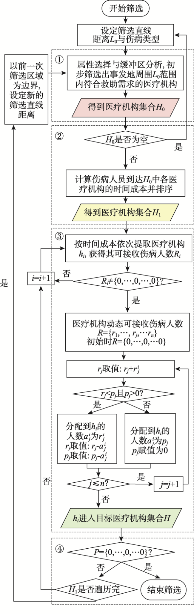
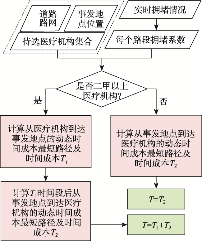
快速选择和分配应急医疗机构是城市突发事件应急响应的一个重要方面。医疗机构的地理位置和城市实时交通是影响城市医疗机构时空可达性的主要因素,医疗机构的资源数量和突发事件的救助需求是否匹配决定了医疗服务的可及性。本文综合考虑以上影响因素,将医疗机构的地理位置、实时道路通行情况、医疗机构等级及其资源数量以及突发事件的救助需求作为选择指标,建立适合城市突发事件应急救助需求的医疗机构选择模型,设计其算法流程并利用青岛市相关数据进行实验,验证其可行性及关键步骤的作用。本文提出的应急医疗机构选择模型及算法能够在推荐医疗机构的同时完成救治人员分配和路线规划,提高了应急医疗机构的选择效率,对城市突发事件应急响应具有一定的应用价值和决策指导意义。
刘晓慧 , 刘永伟 , 蔡菲 , 樊文平 . 面向时空可达性的城市应急医疗机构推荐方法[J]. 地球信息科学学报, 2019 , 21(9) : 1411 -1419 . DOI: 10.12082/dqxxkx.2019.180533
With the rapid development of urbanization in China, urban scale is increasing. The urban population is increasing rapidly, and public emergencies occur frequently, which raises new requirements for emergency management and decision-making of public emergency departments. In cities, the population density is very large and the speed of population flow is fast. Once an emergency occurs in the crowd, there will be so many people involved. Therefore, relevant departments are required to take scientific and efficient emergency response actions timely. It is an important aspect of emergency response for urban emergencies to select and allocate emergency medical institutions. In the process of emergency decision-making, the selection of medical institutions should meet two requirements. On one hand, it should enable the injured to reach the selected medical institutions quickly; On the other hand, it requires the selected medical institutions to have the ability to deal with emergency events and realize the accessibility of emergency medical services. However, geographic location of medical institutions and real-time traffic are the main factors affecting the spatiotemporal accessibility of medical institutions. Meanwhile, the availability of medical services is determined by the matching degree between the resource quantity in medical institutions and emergency assistance need. Based on existing research and the theory of spatiotemporal accessibility, this paper focused on the needs of urban emergency relief, and studied the method to recommend emergency medical institutions for decision-makers. So, the location of medical institutions, real-time traffic, the grade and resources quantity of medical institutions, and the need for emergency assistance were used as choice indicators to define the spatiotemporal accessibility of medical institutions. A medical institution selection model suitable for emergency assistance of city emergencies was proposed, which can recommend medical institutions that meet the emergency response requirements for emergency decision-makers. On this basis, an algorithmic flow for the model was designed, and its feasibility and the role of key steps were verified experimentally. Compared with the traditional accessibility measurement method, the emergency medical institution selection model and algorithm proposed in this paper consider the impact of real-time road traffic situation and the matching degree between emergency rescue demand and emergency resource. Meanwhile, this algorithm can complete the route planning while selecting the most suitable medical assistance institution, which can improve the decision-making efficiency. It is of great practical significance for improving emergency response.
| [1] |
|
| [2] |
杨富平, 武志涛, 袁正午 等. 基于GIS的城市震害单元化应急医疗救助辅助系统[J]. 地震研究, 2010,33(2):227-233.
[
|
| [3] |
|
| [4] |
倪燕 . 考虑伤员受伤程度的应急医疗资源分配优化决策研究[D]. 南京:东南大学, 2015.
[
|
| [5] |
赵洪海, 李明泽, 李忠伟 . 基于最低人员伤亡的资源优化配置模型研究[J]. 安全与环境学报, 2011,11(4):257-259.
[
|
| [6] |
倪玉丽 . 医院医疗应急响应系统的建模与仿真研究[D]. 上海:上海交通大学, 2013.
[
|
| [7] |
韩帅 . 基于应急场景的医疗应急服务系统仿真[D]. 上海:上海交通大学, 2014.
[
|
| [8] |
|
| [9] |
|
| [10] |
|
| [11] |
|
| [12] |
姜艳萍, 王亚, 梁海明 . 应急医疗服务医院选择的方法[J]. 东北大学学报(自然科学版), 2010,31(2):289-292.
[
|
| [13] |
|
| [14] |
|
| [15] |
陈洁, 陆锋, 翟瀚 , 等. 面向活动地点推荐的个人时空可达性方法[J]. 地理学报, 2015,70(6):931-940.
[
|
| [16] |
程敏, 连月娇 . 基于改进潜能模型的城市医疗设施空间可达性——以上海市杨浦区为例[J]. 地理科学进展, 2018,37(2):266-275.
[
|
| [17] |
丁愫, 陈报章 . 城市医疗设施空间分布合理性评估[J]. 地球信息科学学报, 2017,19(2):185-196.
[
|
| [18] |
|
| [19] |
李明, 徐建刚 . 可达性视角的旅游吸引物集聚特征分析——以江苏为例[J]. 遥感信息, 2016,31(5):133-138.
[
|
| [20] |
陈建国, 周素红, 柳林 等. 交通拥堵对急救医疗服务时空可达性的影响——以广州市为例[J]. 地理科学进展, 2016,35(4):431-439.
[
|
| [21] |
|
| [22] |
方志祥, 李清泉, 萧世伦 . 利用时间地理进行位置相关的时空可达性表达[J]. 武汉大学学报·信息科学版, 2010,35(9):1091-1095.
[
|
| [23] |
|
| [24] |
郑智成, 张丽君, 秦耀辰 , 等. 基于互联网地图服务的开封市就医可达性分析[J]. 资源科学, 2018,40(11):2307-2316.
[
|
| [25] |
张童, 姚士谋, 胡伟平 等. 基于交通可达性的广佛都市区城市扩展的模拟与分析[J]. 地理科学, 2018,38(5):737-746.
[
|
/
| 〈 |
|
〉 |