
基于珞珈一号夜间灯光数据的广州市建设用地识别
|
李 翔(1991-),男,河北邯郸人,硕士,主要从事土地利用变化、城市扩张监测方面研究。 |
收稿日期: 2019-01-24
要求修回日期: 2019-07-08
网络出版日期: 2019-12-11
基金资助
广州市城市规划勘测设计研究院年基金项目(No.2018-60)
版权
Mapping Construction Land of Guangzhou based on Luojia No.1 Nightlight Data
Received date: 2019-01-24
Request revised date: 2019-07-08
Online published: 2019-12-11
Supported by
Youth Fund Sustentation Project ofGuangzhou Urban Planning and Design Survey Research Institute(No.2018-60)
Copyright
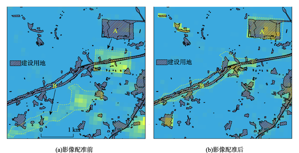
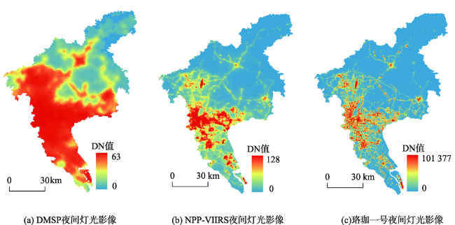
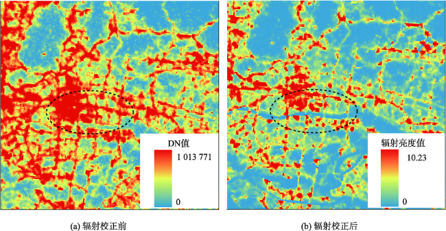
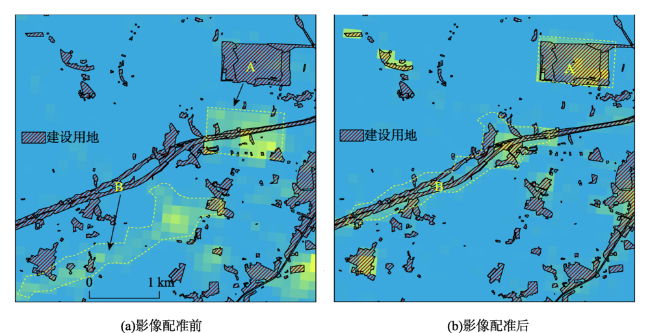
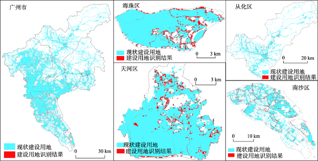
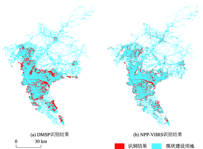
夜间灯光数据和人类活动密切相关,可用于识别城市建设用地。目前主要利用DMSP/OLS和NPP-VIIRS夜间灯光数据进行建设用地识别,由于数据质量原因,这两类数据的识别结果精度较差。珞珈一号夜间灯光数据与比以往夜间灯光数据相比,时间分辨率、空间分辨率和光谱分辨率明显提升,是进行建设用地提取的更理想的数据源。本研究首先对珞珈一号夜间灯光数据进行辐射和影像配准,提高数据质量,然后利用支持向量机(Support Vector Machine, SVM)影像分类方法对广州市2017 年建设用地分区识别,并利用Kappa系数分区、分地类评价识别结果精度。研究发现:① 利用珞珈一号夜间灯光数据识别建设用地的精度明显优于利用DMSP/OLS和NPP-VIIRS夜间灯光数据识别结果的精度;② 广州市中心城区辖区的建设用地识别结果精度较高,识别结果Kappa系数均在0.9以上;外围辖区识别结果精度相对较低,识别结果Kappa系数为0.85左右;③ 城市、建制镇等单个地块面积较大、灯光亮度较高的地类识别结果精度较高,识别结果Kappa系数均在0.9以上;村庄用地、铁路公路用地由于单个地块面积小、布局比较分散、部分路段无照明条件等原因,识别结果Kappa系数相对较低,为0.85左右;采矿、风景及特殊用地夜间基本无人类活动,缺少夜间灯光,难以用夜间灯光数据识别,Kappa系数为0.45左右。本研究证明了利用珞珈一号夜间灯光数据能有效识别建设用地,同时丰富了珞珈一号夜间灯光数据的应用场景。
李翔 , 朱江 , 尹向东 , 姚江春 , 黄嘉玲 , 李密滔 . 基于珞珈一号夜间灯光数据的广州市建设用地识别[J]. 地球信息科学学报, 2019 , 21(11) : 1802 -1810 . DOI: 10.12082/dqxxkx.2019.190041
Nightlight data is closely related to human activities, which can be used for mapping construction land. For now, DMSP/OLS (Defense Meteorological Satellite Program, Operational Linescan System) and NPP-VIIRS (National Polar-orbiting Partnership, Visible Infrared Imaging Radiometer Suite) are the most widely-used data for construction land mapping. However, because of low data quality, the mapping results of these two kinds of data are not good enough. Luojia No.1 nightlight has an obvious quality improvement than existing nightlight data. Using Luojia No.1 nightlight data, we can map construction land more precisely. In this research, we first conducted georeferencing and radiometric correction to Luojia No.1 nightlight data to improve data quality further, then used the Support Vector Machine (SVM) classification method to map the construction land of Guangzhou in 2017 at the district level, and we used Kappa coefficient to check the mapping results. Results show that: (1) Better mapping results can be obtained by using Luojia No.1 nightlight data than the DMSP/OLS and NPP-VIIRS nightlight data. (2) Central districts like Haizhu and Tianhe's Kappa coefficients of mapping results are over 0.9. However, remote districts like Conghua and Nansha had relatively low Kappa coefficients of about 0.85. (3) Construction land like city, town, and airport had high Kappa coefficients usually over 0.9, because the nightlight emitted by these lands is easily to capture. In comparison, rural construction land’s single massif was small, and some sections of road and railway lacked lighting condition; thus, these lands are a little harder to recognize in the nightlight data. Correspondingly, their Kappa coefficients were about 0.85. Besides, land of the mining industry and scenic tourism seldom emit light at night, it is hard to identify these lands in Luojia No.1 nightlight data. Therefore, the Kappa coefficients of these lands are pretty low, about 0.45. Our findings suggest that Luojia No.1 nightlight data's great potential in mapping construction land.
表1 数据来源及主要参数Tab. 1 Data sources and main parameters |
| 类型 | 名称 | 数据来源 | 数据时间 |
|---|---|---|---|
| 矢量数据 | 广州市土地利用现状数据 | 广州市规划与自然资源局会 | 2017年12月 |
| 广州市区级行政区划 | |||
| 影像数据 | DMSP/OLS夜间灯光数据 | 美国国家航空航天局 | 2013年 |
| NPP-VIIRS夜间灯光数据 | 2018年5月 | ||
| 珞珈一号夜间灯光数据 | 湖北省高分辨率对地观测系统数据与应用网 | 2018年9月 |
表2 DMSP/OLS、NPP-VIIRS、珞珈一号3种灯光数据主要参数对比Tab. 2 Comparison of main parameters of the DMSP/OLS, NPP-VIIRS, and Luojia No.1 nightlight data |
| 数据名称 | 时间分辨率 | 空间分辨率/m | 光谱分辨率/bit |
|---|---|---|---|
| DMSP/OLS | 年际 | 1000 | 6 |
| NPP-VIIRS | 月际 | 750 | 10 |
| 珞珈一号 | 15 d | 130 | 15 |
表3 广州市各区建设用地识别结果Kappa系数Tab. 3 Comparison of the Kappa coefficients based onthe DMSP/OLS, NPP-VIIRS, and Luojia No.1 nightlight data |
| 行政区划 | 越秀 | 天河 | 海珠 | 荔湾 | 黄埔 | 番禺 | 白云 | 花都 | 从化 | 增城 | 南沙 |
|---|---|---|---|---|---|---|---|---|---|---|---|
| Kappa系数 | 0.9602 | 0.9173 | 0.9213 | 0.8918 | 0.9116 | 0.9051 | 0.8814 | 0.9003 | 0.8551 | 0.8613 | 0.8424 |
表4 珞珈一号夜间灯光数据各类建设用地识别结果Kappa系数Tab. 4 Kappa coefficients of different kinds of construction lands' mapping results of Luojia No.1 nightlight data |
| 地类名称 | 城市 | 建制镇 | 村庄 | 采矿 | 风景及特殊用地 | 港口码头 | 公路 | 铁路 | 机场 |
|---|---|---|---|---|---|---|---|---|---|
| Kappa 系数 | 0.9265 | 0.9054 | 0.8515 | 0.4556 | 0.4413 | 0.9651 | 0.8546 | 0.8574 | 0.9877 |
图6 DMSP/OLS和NPP-VIIRS夜间灯光数据识别结果对比Fig. 6 Comparison of the construction land mapping results based onthe DMSP/OLS and NPP-VIIRS nightlight data |
表5 DMSP/OLS和NPP-VIIRS数据各类建设用地识别结果精度Tab. 5 Kappa coefficients of all different kinds of construction lands' recognition mapping results of DMSP/OLS and NPP-VIIRS nightlight data |
| 地类名称 | 城市 | 建制镇 | 村庄 | 采矿 | 风景及特殊用地 | 港口码头 | 公路 | 铁路 | 机场 |
|---|---|---|---|---|---|---|---|---|---|
| Kappa系数(DMSP/OLS) | 0.6745 | 0.6526 | 0.3314 | 0.1112 | 0.0081 | 0.7314 | 0.3346 | 0.3178 | 0.8112 |
| Kappa系数(NPP-VIIRS) | 0.7643 | 0.7344 | 0.3486 | 0.1365 | 0.0123 | 0.7855 | 0.4015 | 0.3677 | 0.8426 |
| [1] |
李翔, 陈振杰, 吴洁璇 , 等. 基于夜间灯光数据和空间回归模型的城市常住人口格网化方法研究[J]. 地球信息科学学报, 2017,19(10):1298-1305.
[
|
| [2] |
汪文祥 . Landsat影像时间序列支持下的土地利用变化检测方法研究[D]. 南京:南京大学, 2018.
[
|
| [3] |
杨任飞, 罗红霞, 周盛 , 等. 夜间灯光数据驱动的成渝城市群空间形成过程重建及分析[J]. 地球信息科学学报, 2017,19(5):653-661.
[
|
| [4] |
|
| [5] |
|
| [6] |
邓刘洋, 沈占锋, 柯映明 . 城市建成区遥感影像边界提取与扩张分析[J]. 地球信息科学学报, 2018,20(7):996-1003.
[
|
| [7] |
|
| [8] |
|
| [9] |
王少剑, 苏泳娴, 赵亚博 . 中国城市能源消费碳排放的区域差异、空间溢出效应及影响因素[J]. 地理学报, 2018,73(3):414-428.
[
|
| [10] |
舒松, 余柏蒗, 吴健平 等. 基于夜间灯光数据的城市建成区提取方法评价与应用[J]. 遥感技术与应用, 2011,26(2):169-176.
[
|
| [11] |
王晓慧 . 基于DMSP/OLS夜间灯光数据的中国近30年城镇扩展研究[D]. 南京:南京大学, 2013.
[
|
| [12] |
杨浩, 孟娜, 王婧 , 等. 基于支持向量机的京津冀城市群热环境时空形态模拟[J]. 地球信息科学学报, 2019,21(2):190-200.
[
|
| [13] |
|
| [14] |
|
| [15] |
曹子阳, 吴志峰, 匡耀求 , 等. DMSP/OLS夜间灯光影像中国区域的校正及应用[J]. 地球信息科学学报, 2015,17(9):1092-1102.
[
|
| [16] |
郭晗 . 珞珈一号科学试验卫星[J].卫星应用, 2018(7):70.
[
|
| [17] |
|
| [18] |
单治彬, 孔金玲, 张永庭 , 等. 面向对象的特色农作物种植遥感调查方法研究[J]. 地球信息科学学报, 2018,20(10):1509-1519.
[
|
| [19] |
谢福鼎, 姚娆 . 基于GANBPSO-SVM的高光谱影像特征选择方法[J]. 地理科学, 2018,38(6):972-978.
[
|
| [20] |
|
| [21] |
丁世飞, 齐丙娟, 谭红艳 . 支持向量机理论与算法研究综述[J]. 电子科技大学学报, 2011,40(1):2-10.
[
|
| [22] |
杨清可, 段学军, 金志丰 等. 南通市建设用地扩张情景模拟与景观生态效应[J]. 地理科学, 2017,37(4):528-536.
[
|
/
| 〈 |
|
〉 |
