
基于GridMet模型的浙江省温湿指数空间分布及地形影响分析
|
施国萍(1984-),女,江苏南京人,博士,讲师,主要从事3S集成与气象应用研究。E-mail: shiguopingnj@163.com |
收稿日期: 2018-12-05
要求修回日期: 2019-05-22
网络出版日期: 2019-12-25
基金资助
国家自然科学基金青年项目(41805083)
国家自然科学基金项目(41330529)
江苏省第四期“333高层次人才培养工程”科研项目(BRA2014373)
版权
Spatial Distribution of THI in Zhejiang Province based on the GridMet Model
Received date: 2018-12-05
Request revised date: 2019-05-22
Online published: 2019-12-25
Supported by
National Natural Science Foundation of China(41805083)
National Natural Science Foundation of China(41330529)
The forth "333 High-level Talents Training Project" of Jiangsu province(BRA2014373)
Copyright
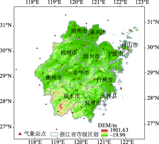
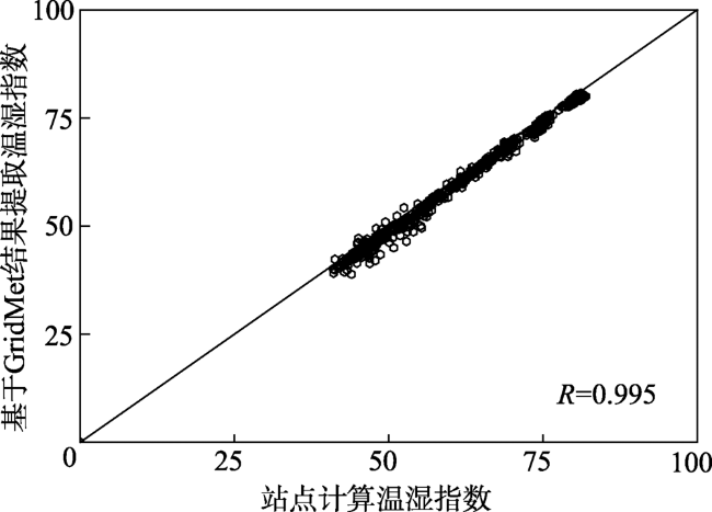
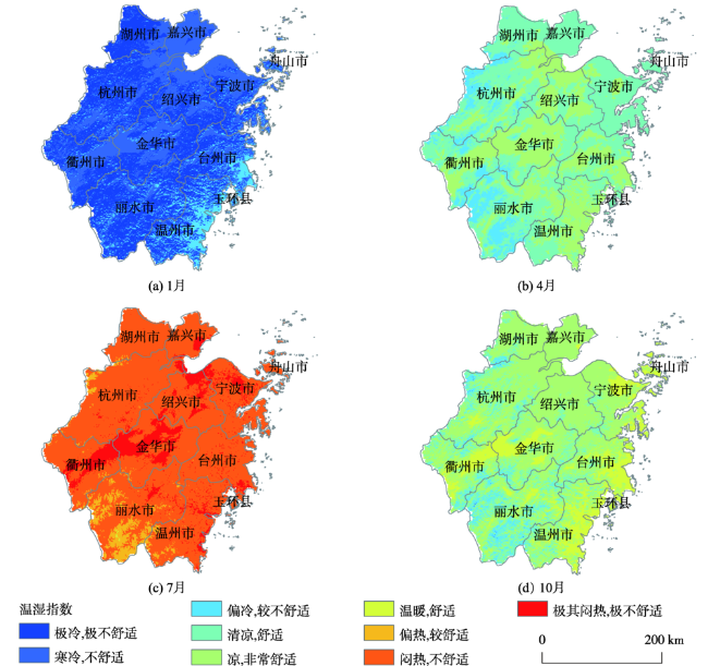
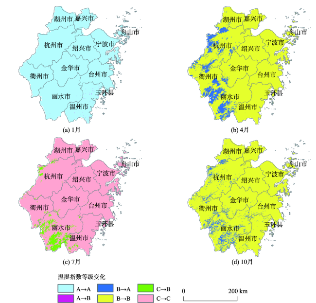
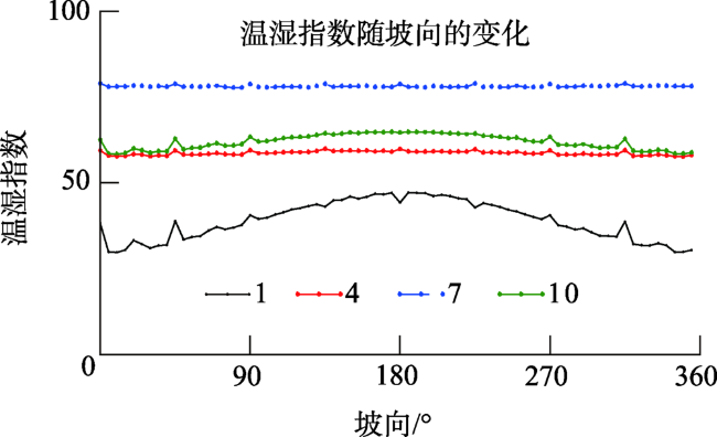
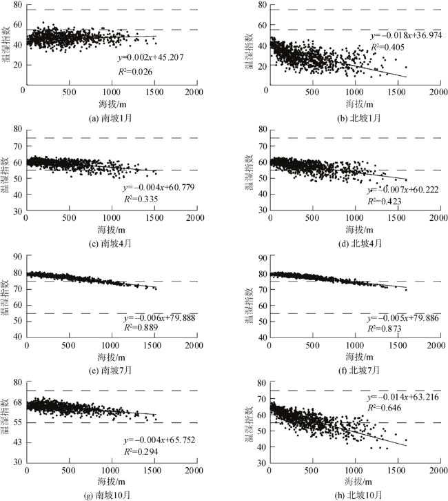
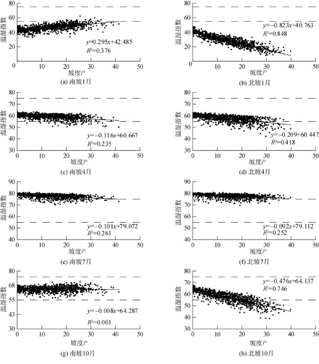
温湿指数是气候舒适度评价模型之一,通过温度与湿度的组合反映人体与周围环境的热量交换,本文利用2003-2018年浙江省及其周边71个气象站点月平均气温、地面水汽压数据,以及MODIS水汽产品,基于GridMet模型模拟了浙江省各月温湿指数空间分布(100 m×100 m),分析了浙江省温湿指数随地形因子(海拔、坡度、坡向)变化的特征;讨论了各地形因子对温湿指数空间分布的影响程度。结果表明:① 海拔、坡度、坡向3个地形因子中,1月温湿指数随坡向的变化最大,7月最小;② 同坡向上,坡度变化对1月温湿指数影响较大,而海拔变化则是对7月影响最大;③ 南坡1月温湿指数随海拔和坡度增加均略为增加,南坡其他月份及北坡各月均为随海拔和坡度增加温湿指数减小;④ 北坡相对于南坡而言,海拔和坡度对温湿指数的影响更为明显。浙江大部分山区由于地形影响,夏季较为“舒适”,适宜建立避暑消夏的旅游项目。
施国萍 , 何永健 , 张眉 , 邱新法 , 曾燕 . 基于GridMet模型的浙江省温湿指数空间分布及地形影响分析[J]. 地球信息科学学报, 2019 , 21(12) : 1923 -1933 . DOI: 10.12082/dqxxkx.2019.180635
The temperature and humidity index is one of the climate comfort evaluation models, which reflects the heat exchange between human body and the surrounding environment through the combination of temperature and humidity.Based on the GridMet model, the spatial distribution of temperature and humidity indices(THI)in ZhejiangProvince(100 m×100 m)weresimulated by using monthly average air temperature, relative humidity from 71 meteorological stations, and MODIS 05over Zhejiang and surrounding areas during 2003-2018. Furthermore, we analyzed the distribution characteristics of THI in Zhejiang with the terrain factors (elevation, gradient, slope direction). The influence of terrain factors on the spatial distribution of the THIwas discussed. The results show that most montane areas in Zhejiang were more comfortable in summer due to the topographic influence, and thus, are suitable for establishing summer tourism projects. Specifically, among the three topographic factors of elevation, slope, and aspect, the THI in January changed the most with the slope direction and the least in July.On the same slope, the change of slope degree had a greater impact on the THI in January, while the change of altitude had the greatest impact in July. The THI in January on the south slope increased slightly with the increase of elevation and slope degree, while in other months on the south slope and on the north slopeTHI increased slightly with the elevation, and the sum of the THI decreased with the increase of slope gradient. Compared with the south slope, the influences of elevation and slope gradient on THIwere more obvious on the north slope.
表1 温湿指数等级划分Tab. 1 Index of THI |
| 等级 | 温湿指数(THI) | 级别内涵 | 冷热级别 |
|---|---|---|---|
| 1级 | <40 | 极冷,极不舒适 | A冷,不舒适 |
| 2级 | 40~45 | 寒冷,不舒适 | |
| 3级 | 45~55 | 偏冷,较不舒适 | |
| 4级 | 55~60 | 清凉,舒适 | B舒适 |
| 5级 | 60~65 | 凉,非常舒适 | |
| 6级 | 65~70 | 温暖,舒适 | |
| 7级 | 70~75 | 偏热,较舒适 | |
| 8级 | 75~80 | 闷热,不舒适 | C闷热,不舒适 |
| 9级 | >80 | 极其闷热,极不舒适 |
| [1] |
孙根年, 余志康 . 中国30°N、35°N线城市气候舒适度与地形三级阶梯的关系[J]. 干旱区地理(汉文版), 2014,37(3):447-457.
[
|
| [2] |
马丽君, 孙根年, 谢越法 , 等. 50年来东部典型城市旅游气候舒适度变化分析[J]. 资源科学, 2010,32(10):1963-1970.
[
|
| [3] |
|
| [4] |
闫业超, 岳书平, 刘学华 , 等. 国内外气候舒适度评价研究进展[J]. 地球科学进展, 2013,28(10):1119-1125.
[
|
| [5] |
韩会庆, 黄娅, 蔡广鹏 , 等. 1961-2010年贵州省气候舒适度时空变化特征[J]. 四川师范大学学报(自然科学版), 2018,41(1):138-142.
[
|
| [6] |
邱粲, 曹洁, 林隆超 , 等. 基于GIS的山东省旅游气候舒适度精细化评估[J]. 资源科学, 2013,35(12):2501-2506.
[
|
| [7] |
王林林 . 基于DEM的山东省气候舒适度时空分布研究[J]. 水土保持研究, 2015,22(4):258-264.
[
|
| [8] |
张狄, 史岚, 丁浒 , 等. 华东地区气候舒适度精细化估算及其分布特征研究[J]. 云南大学学报(自然科学版), 2015,37(5):695-704.
[
|
| [9] |
陆琦, 邱新法 . 基于GIS的月平均气温空间化方法的比较研究[J]. 科技通报, 2017,33(3):43-48.
[
|
| [10] |
|
| [11] |
张丹, 刘昌明, 付永锋 , 等. 基于MODIS数据的中国地面水汽压模拟与分析[J]. 资源科学, 2012,34(1):74-80.
[
|
| [12] |
谭璐璐, 史岚, 王茜雯 , 等. 中国区域空中水资源的计算与订正[J]. 江苏农业科学, 2018,46(8), 307-311.
[
|
| [13] |
浙江省旅游局. 2018年浙江省旅游工作报告[EB/OL]. [2018-01-24].
[ Tourism Bureau of Zhejiang Province. 2018 Zhejiang province tourism work report[EB/OL].[2018-01-24]. ]
|
| [14] |
国家信息中心分享经济研究中心. . 2018中国共享住宿发展报告(2018) [EB/OL]. [2018-05-18].
[ National Information Center Sharing Economic Research Center. 2018. China sharing accommodation development report (2018) [EB/OL].[2018-01-24].
|
| [15] |
浙江省旅游局. 2018. 2017年浙江省旅游业基本情况[EB/OL]. [2018-01-26].
[ Tourism Bureau of Zhejiang Province. 2018. Basic information of tourism in zhejiang province in 2017 [EB/OL].[2018-01-24].
|
| [16] |
李梦洁 . 浙江省山地热量资源分布式模拟[D]. 南京: 南京信息工程大学, 2008.
[
|
| [17] |
|
| [18] |
张丹, 邱新法, 曾燕 . 浙江省高分辨率气温空间分布图的计算与绘制[J]. 大气科学学报, 2011,34(2):215-224.
[
|
| [19] |
王幸, 曾燕, 邱新法 . 基于复杂地形下月平均气温分布式模拟的山区逆温研究[J]. 科学技术与工程, 2015(24):1-8.
[
|
| [20] |
李梦洁 . 浙江省山地热量资源分布式模拟[D]. 南京:南京信息工程大学, 2008.
[
|
| [21] |
王丹丹, 邱新法, 曾燕 , 等. 基于分布式模型模拟的茶树种植适宜性区划[J]. 气象科学, 2018,38(1)1:121-129.
[
|
| [22] |
曾燕, 邱新法, 何永健 , 等. 起伏地形下黄河流域太阳散射辐射分布式模拟研究[J]. 地球物理学报, 2008,51(4):991-998.
[
|
| [23] |
曾燕, 邱新法, 刘绍民 . 起伏地形下天文辐射分布式估算模型[J]. 地球物理学报, 2005,48(5):1028-1033.
[
|
| [24] |
曾燕, 邱新法, 刘昌明 , 等. 起伏地形下黄河流域太阳直接辐射分布式模拟[J]. 地理学报, 2005,15:680-688.
[
|
| [25] |
|
| [26] |
李梦洁, 郑建飞, 曾燕 , 等. 浙江省高分辨率太阳直接辐射图的计算和绘制[J]. 地球科学进展, 2008,23(3):299-305.
[
|
| [27] |
尹静秋, 邱新法, 何永健 , 等. 起伏地形下浙江省散射辐射时空分异规律模拟[J]. 大气科学学报, 2011,34(1):93-98.
[
|
/
| 〈 |
|
〉 |