
地理图斑智能计算及模式挖掘方法研究
|
骆剑承(1970— ),男,浙江杭州人,博士,研究员,主要从事遥感大数据智能计算研究。E-mail:luojc@radi.ac.cn |
收稿日期: 2019-08-21
要求修回日期: 2019-11-04
网络出版日期: 2020-04-08
基金资助
国家自然科学基金项目(41631179)
国家自然科学基金项目(41601437)
国家重点研发计划项目(2017YFB0503600)
版权
Methods of Intelligent Computation and Pattern Mining based on Geo-parcels
Received date: 2019-08-21
Request revised date: 2019-11-04
Online published: 2020-04-08
Supported by
National Natural Science Foundation of China(41631179)
National Natural Science Foundation of China(41601437)
National Key Research and Development Program of China(2017YFB0503600)
Copyright
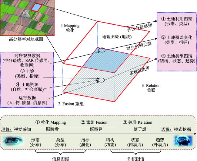
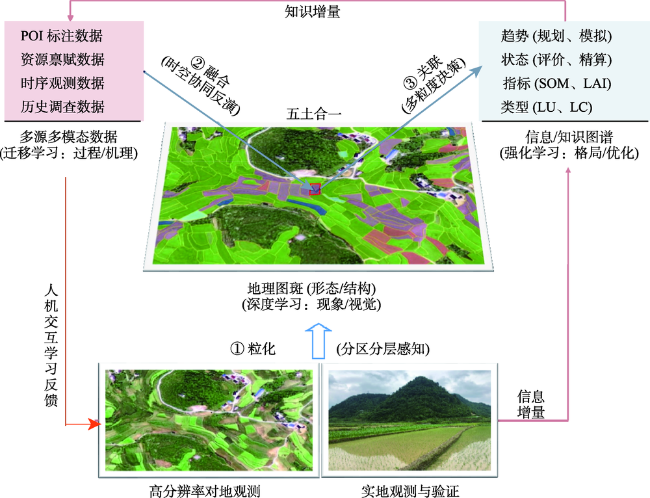
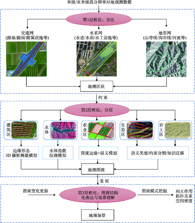
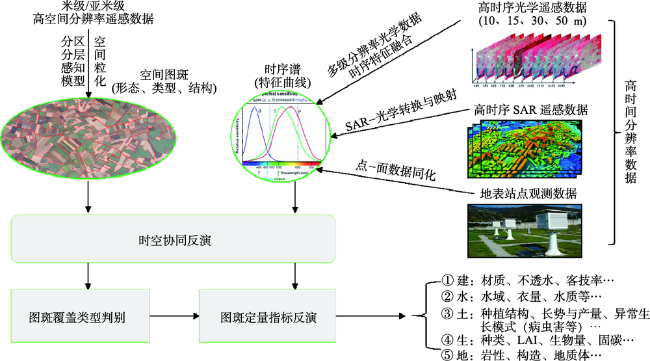
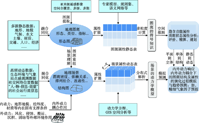
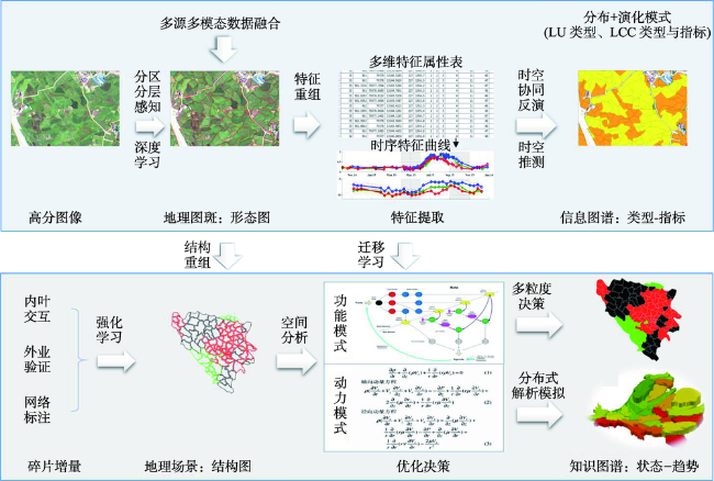
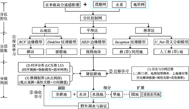
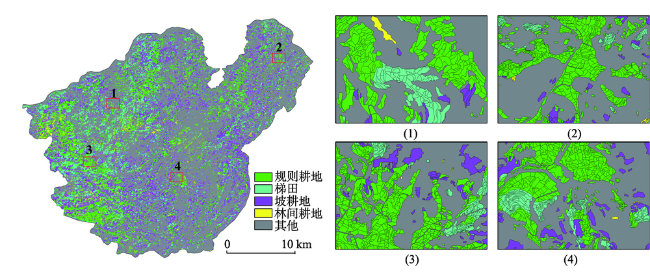
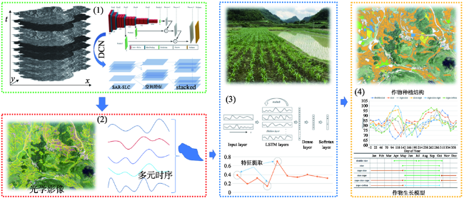
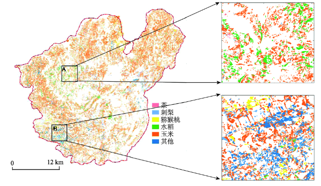
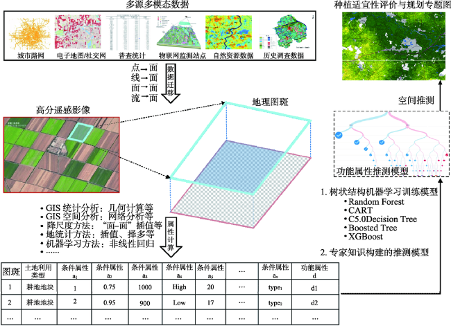
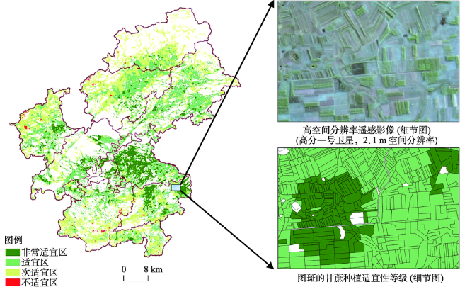
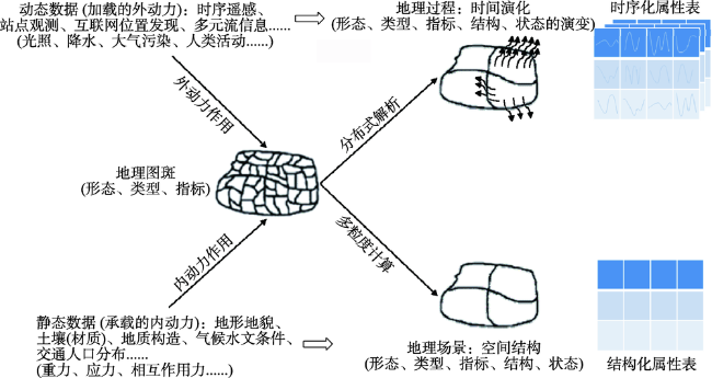
在大数据时代,高分辨率对地观测技术实现了对地球表层地理现象和地理过程最为真实、量化、全面覆盖又快速更新的数据化记录,可为地理空间认知研究的新发展奠定时空信息聚合与挖掘计算的基准。地理图斑是影像空间映射到地理空间中对于地理实体的抽象化表达,是构建地理场景和承载地理空间各类信息进而开展模式挖掘的最小单元。本文以地理图斑为基本对象,通过分析其中视觉模拟、符号推测等几类机器学习的协同计算机制,从空间、时间与属性等维度构建了集“分区分层感知”、“时空协同反演”、“多粒度决策”三者于一体的地理图斑智能计算模型,并以在贵州息烽县、广西江州区开展的农业种植结构制图与规划决策为应用案例,探索了地理图斑分布、生长以及功能3种模式的挖掘方法,并进一步设计了动态视角下开展图斑动力模式挖掘的研究思路。

骆剑承 , 吴田军 , 吴志峰 , 周亚男 , 郜丽静 , 孙营伟 , 吴炜 , 杨颖频 , 胡晓东 , 张新 , 沈占锋 . 地理图斑智能计算及模式挖掘方法研究[J]. 地球信息科学学报, 2020 , 22(1) : 57 -75 . DOI: 10.12082/dqxxkx.2020.190462
In the era of big data, high-resolution Earth observation technologies have been able to provide the most authentic, quantitative, comprehensive-coverage, and fast-updating data about the geographic phenomena and processes on the Earth's surface. Such data provide precise spatiotemporal benchmarks of information aggregation and computation of data mining for new developments of geospatial cognitive research. Geo-parcels are abstract expressions for mapping geographical entities from image-space to geographic-space. Geo-parcels are the smallest units of pattern mining with the construction of geographic scenes and loading various geospatial information. In this paper, a synergistic calculation mechanism with the machine learning methods of visual simulation and symbol inference were analyzed based on the basic unit of geo-parcels. From the dimensions of space, time, and attribute, we constructed an intelligent computation model based on geo-parcels by integrating three sub-models: zoning-stratified perception, spatiotemporal synergistically inversion, and multi-granular decision-making. Furthermore, this paper explored the pattern mining methods of geo-parcels for their distribution, growth, and function via two case studies: the agricultural planting structure mapping in Xifeng County, Guizhou province and the planning decision in Jiangzhou District of Guangxi Zhuang Autonomous Region.
| [1] |
宫鹏 . 对遥感科学应用的一点看法[J]. 遥感学报, 2019,23(4):567-569.
[
|
| [2] |
李德仁, 张良培, 夏桂松 . 遥感大数据自动分析与数据挖掘[J]. 测绘学报, 2014,43(12):1211-1216.
[
|
| [3] |
骆剑承, 吴田军, 李均力 , 等. 遥感图谱认知[M]. 北京: 科学出版社, 2017.
[
|
| [4] |
|
| [5] |
骆剑承, 吴田军, 夏列钢 . 遥感图谱认知理论与计算[J]. 地球信息科学学报, 2016,18(5):578-589.
[
|
| [6] |
李秦, 高锡章, 张涛 , 等. 最优分割尺度下的多层次遥感地物分类实验分析[J]. 地球信息科学学报, 2011,13(3):409-417.
[
|
| [7] |
陶超, 谭毅华, 蔡华杰 , 等. 面向对象的高分辨率遥感影像城区建筑物分级提取方法[J]. 测绘学报, 2010,39(1):39-45.
[
|
| [8] |
|
| [9] |
自然资源部. 第三次全国国土调查实施方案[R]. 2018年18号文件, 2018.
[ Ministry of Natural Resources. Third national land survey implementation plan[R]. Document No.18 in 2018, 2018. ]
|
| [10] |
|
| [11] |
|
| [12] |
|
| [13] |
|
| [14] |
|
| [15] |
|
| [16] |
|
| [17] |
李志刚, 张小勇, 艾廷华 . 土地利用图斑综合研究[J]. 地理空间信息, 2004,2(3):13-18.
[
|
| [18] |
|
| [19] |
|
| [20] |
|
| [21] |
|
| [22] |
|
| [23] |
童庆禧, 张兵, 郑兰芬 . 高光谱遥感:原理,技术与应用[M]. 北京: 高等教育出版社, 2006.
[
|
| [24] |
|
| [25] |
|
| [26] |
|
| [27] |
|
| [28] |
|
| [29] |
裴韬, 刘亚溪, 郭思慧 , 等. 地理大数据挖掘的本质[J]. 地理学报, 2019,74(3):586-598.
[
|
| [30] |
李德仁, 王树良, 史文中 , 等. 论空间数据挖掘和知识发现[J]. 武汉大学学报·信息科学版, 2001,26(6):491-499.
[
|
| [31] |
李德仁, 王树良, 李德毅 , 等. 论空间数据挖掘和知识发现的理论与方法[J]. 武汉大学学报·信息科学版, 2002,27(3):221-233.
[
|
| [32] |
|
| [33] |
|
| [34] |
陈劲松, 黄健熙, 林珲 , 等. 基于遥感信息和作物生长模型同化的水稻估产方法研究[J]. 中国科学:信息科学, 2010,S1(40):173-183.
[
|
| [35] |
|
| [36] |
|
| [37] |
|
| [38] |
|
| [39] |
|
| [40] |
|
| [41] |
|
| [42] |
|
| [43] |
|
| [44] |
|
| [45] |
|
| [46] |
|
| [47] |
|
| [48] |
|
| [49] |
|
| [50] |
|
| [51] |
|
| [52] |
傅伯杰, 刘焱序 . 系统认知土地资源的理论与方法[J]. 科学通报, 2019,64(21):2172-2179.
[
|
/
| 〈 |
|
〉 |