
地理国情监测成果与规划用地数据的关联转换方法
|
刘 稳(1991— ),男,湖北咸宁人,博士生,现主要从事大数据在国土空间规划中的应用、数字城乡规划与管理等研究。E-mail: lw_whu@whu.edu.cn |
收稿日期: 2019-06-17
要求修回日期: 2019-09-08
网络出版日期: 2020-04-13
基金资助
国家自然科学基金项目(41331175)
国家自然科学基金项目(51878515)
版权
A Method for Association and Conversion between Geographical Condition Monitoring Data and Urban Planning Land Use Data
Received date: 2019-06-17
Request revised date: 2019-09-08
Online published: 2020-04-13
Supported by
National Natural Science Foundation of China(41331175)
National Natural Science Foundation of China(51878515)
Copyright
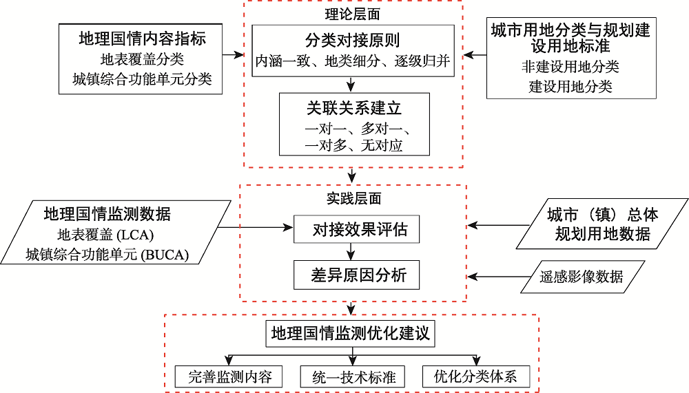
国土空间规划作为促进空间科学治理、实现可持续发展的重要手段,在解决以往各类规划交叉重叠等问题的同时,对空间规划基础底数提出了新要求。将客观、精细的地理国情监测成果作为重要关联数据整合进国土空间基础信息平台,可以大大提高国土空间规划的科学性和权威性。本文首先梳理地理国情内容指标与国土空间规划核心内容之一的城市(镇)总体规划用地分类体系之间的差异,然后构建地理国情监测数据与规划用地数据关联转换的总体框架和具体方法,最后以武汉市为例开展具体应用实践并提出地理国情监测的优化建议。研究表明,地理国情监测成果与规划用地数据的关联转换方法可以用于2种分类体系地类关联关系的建立并实现两类数据的对接转换,但不同地类的转换效果存在差异;地理国情内容指标与城乡用地分类以“多对一”关联关系为主,较难实现两类数据的直接转换,但城镇综合功能单元与城市建设用地部分地类的关联关系较明确且数据转换一致性较高;要实现地理国情监测成果与规划用地数据的无缝衔接和有效转换,应进一步完善监测内容,统一技术标准,优化分类体系。研究结果为优化完善地理国情监测成果,促进其在国土空间规划中的应用提供了有效参考和科学依据。
刘稳 , 詹庆明 , 刘权毅 , 司瑶 , 黄启雷 , 樊智宇 . 地理国情监测成果与规划用地数据的关联转换方法[J]. 地球信息科学学报, 2020 , 22(2) : 161 -174 . DOI: 10.12082/dqxxkx.2020.190309
In the context of institutional adjustments and planning system reform, spatial planning has become a prominent approach to effectively supporting land resource management in a more scientific and sustainable manner. However, new requirements arise for basic map data of spatial planning to better settle the overlaps and contradictions among land use planning, urban master planning, and major function zoning. Integrating geographical condition monitoring data, which has the advantages of objectivity, precision, and accuracy, as an important data into the basic information platform of territorial space can greatly improve the solidity and authority of spatial planning. Firstly, this paper analyzed the differences between the two classification systems of geographical condition and land uses for urban master planning. Then, the overall framework for the association and conversion between geographic condition monitoring data and land use data of urban master planning was constructed, and specific methods were proposed from four aspects: the correspondence principle, corresponding relationships, consistency evaluation, and difference analysis. Finally, suggestions for optimizing geographical condition monitoring were proposed by taking an urban-rural fringe area in Wuhan for experimental study. Results show that the method of association and conversion between geographical condition monitoring data and urban planning land use data could be used to establish the relationship between the two classifications and to realize the conversion from geographic monitoring data to land use data for urban master planning, but the conversion effect of different land use types varied to some extent. The many-to-one corresponding relationship mainly existed between the classification of geographical condition and the classification of urban-rural land uses, thus difficult to implement the direct conversion. A clear corresponding relationship could be established between urban comprehensive functional unit and some types of urban construction land, and there was a relatively high consistency between them. To realize seamless connection and effective conversion between geographic national condition monitoring data and land use data for urban master planning, we should further improve monitoring content, optimize land use classification, and unify technical standards, so as to better apply geographical condition monitoring data in spatial planning. Our findings provide an effective reference and scientific basis for optimizing and improving the affairs of geographical condition monitoring in the future and for promoting its applications in natural resource management and spatial planning.
表1 地理国情监测成果与规划用地数据分类体系的差异分析Tab. 1 Differences between the geographical condition classification and the land use classification for urban master planning |
| 类别 | 地理国情内容指标 | 规划用地分类体系 | |
|---|---|---|---|
| 工作目标 | 制定背景 | 为全面掌握我国自然和人文地理国情信息,服务于防灾减灾、应急保障及相关行业调查统计等工作 | 为城乡统筹与城市规划及管理提供依据 |
| 关注重点 | 侧重反映国土资源要素的自然状态和现状特征 | 侧重反映土地的主要使用功能或规划用途,尤其是建设用地的现状建设状态与功能性质 | |
| 技术指标 | 数据来源 | 遥感影像为基础,辅以人口统计、社会经济及各专项调查 | 遥感影像、规划用地许可和建筑工程许可等审批信息 |
| 数据精度 | 耕地、园地、水域、其他地区林地和草地一般为400 m2,大面积林区、草原地区、房屋建筑区、人工堆掘地为1600 m2,绿化林地、绿化草地、独立房屋建筑为200 m2,荒漠地区为10 000 m2; 居住小区为5000 m2,休闲娱乐景区为50 000 m2,体育活动场所、名胜古迹、宗教场所为10 000 m2 | 非建设用地分类:耕地、园地为600 m2,林地、草地等其他地类为1500 m2等 建设用地分类:无最小上图面积 | |
| 数学基础 | 2000国家大地坐标系,1985国家高程基准 | 1954北京坐标系,1985国家高程基准 | |
| 分类标准 | 构成内容 | 包括地表覆盖、地理国情要素、地表形态3个方面,采用三级分类体系,形成12一级类,58二级类,135三级类 | 包括城乡用地分类与城市建设用地两部分,采用三级分类体系,前者2大类、9中类、14小类,后者8大类、35中类、42小类 |
| 分类对象 | 采用要素模型来描述,分为点、线、面、体4种 | 采用面状要素来描述 | |
注:以上分类体系的差异对比采用的是《地理国情普查内容与指标》(GDPJ 01-2013)、《城市用地分类与规划建设用地标准》(GB50137-2011)。 |
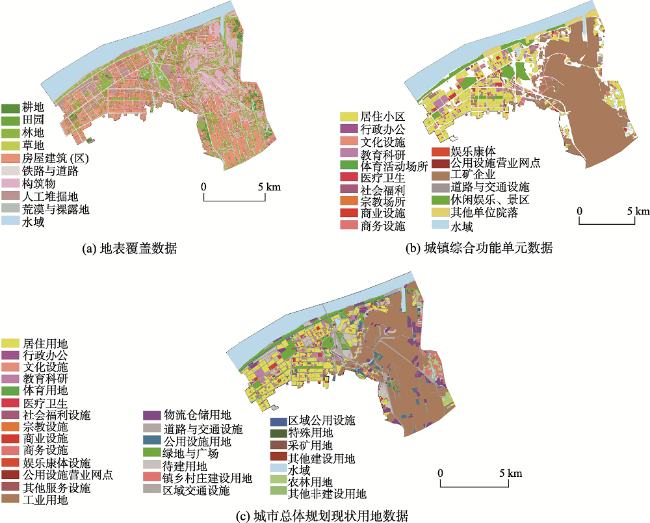
表2 武汉市地理国情内容指标与城乡用地分类的关联关系Tab.2 Corresponding relationships between the geographical condition classification and the urban-rural land classification in Wuhan |
| 城乡用地分类 | 地理国情内容指标 | |
|---|---|---|
| 大类 | 中类 | |
| 建设用地 | 城乡居民点建设用地(H1) | 地表覆盖:房屋建筑区(0500)、绿化林地(0360)、人工草地(0420)、硬化地表(0710)、城墙(0740)、固化池(0760)、工业设施(0770)、其他构筑物(0790)、垃圾堆放物(0822)、其他堆放物(0829)、建筑工地(0830) 地理国情要素:城镇综合功能单元(1140) |
| 区域交通设施用地(H2) | 地表覆盖:护坡灌草(0424)、停机坪与跑道(0714)、硬化护坡(0715)、道路建筑工地(0833) 地理国情要素:单位院落(1143) | |
| 区域公用设施用地(H3) | 地表覆盖:堤坝(0721)、沙障(0780)、垃圾堆放物(0822) 地理国情要素:城镇综合功能单元中的工矿企业(1142)、单位院落(1143) | |
| 特殊用地(H4) | — | |
| 采矿用地(H5) | 地表覆盖:晒盐地(0763)、露天采掘场(0810)、尾矿堆放物(0821) | |
| 其他建设用地(H9) | 地表覆盖:建筑工地(0830)、其他人工堆掘地(0890) | |
| 非建设用地 | 水域(E1) | 地表覆盖:水面(1001)、水渠(1012)、冰川与常年积雪(1050) 地理国情要素:水域(1000) |
| 农林用地(E2) | 地表覆盖:耕地(0110-0120)、园地(0130-0190)、林地(0310-0380)、牧草地(03A1)、场院(0716)、温室大棚(0750) | |
| 其他非建设用地(E9) | 地表覆盖:荒漠与裸露地(0900)、固沙灌草(03A3)、护坡灌草(03A4) | |
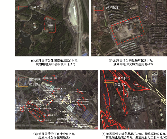
表3 武汉市地理国情内容指标与城市建设用地分类的关联关系Tab. 3 Corresponding relationship between the geographical condition classification and the urban development land classification in Wuhan |
| 城市建设用地分类 | 地理国情内容指标 | |||
|---|---|---|---|---|
| 大类 | 中类 | 城镇综合功能单元分类 | 地表覆盖分类 | |
| 居住用地(R) | 居住小区(1141) | 人工堆掘地(0800)等 | ||
| 公共管理与公共服务用地(A) | 行政办公用地(A1) | 行政办公(114A) | 露天体育场(0712)、城墙(0740)、游泳池(0761)等 | |
| 文化设施用地(A2) | 文化设施(114B) | |||
| 教育科研用地(A3) | 教育科研(114C) | |||
| 体育用地(A4) | 体育活动场所(1145) | |||
| 医疗卫生用地(A5) | 医疗卫生(114D) | |||
| 社会福利设施用地(A6) | 社会福利(114E) | |||
| 文物古迹用地(A7) | 名胜古迹(1146) | |||
| 外事用地(A8) | — | |||
| 宗教用地(A9) | 宗教场所(1147) | |||
| 商业服务业设施用地(B) | 商业设施用地(B1) | 商业设施(114F) | 加油(气)充电站(0736)等 | |
| 商务设施用地(B2) | 商务设施(114G) | |||
| 娱乐康体用地(B3) | 娱乐康体(114H) | |||
| 体育活动场所(1145) | ||||
| 公用设施营业网点用地(B4) | 公用设施营业网点(114I) | |||
| 其他服务业用地(B9) | — | |||
| 工业用地(M) | 工矿企业(1142) | 污水处理池(0762)、晒盐池(0763)、其他固化池(0769)、工业设施(0770)等 | ||
| 物流仓储用地(W) | 工矿企业(1142) | 露天堆放场(0717)等 | ||
| 道路与交通设施用地(S) | 城市道路用地(S1) | — | 道路(0600)、停车场(0713)、道路建筑工地(0833)等 | |
| 城市轨道交通用地(S2) | — | |||
| 交通枢纽用地(S3) | 交通设施(114K) | |||
| 交通场站用地(S4) | 交通设施(114K) | |||
| 其他交通设施用地(S9) | 交通设施(114K) | |||
| 公用设施用地(U) | 工矿企业(1142)、其他单位院落(114J) | 硬化护坡(0715)、堤坝(0721)、垃圾堆放物(0822)等 | ||
| 绿地与广场用地(G) | 公园绿地(G1) | 休闲娱乐景区(1144) | 绿化林地(0360)、人工草地(0420)、广场(0711)等 | |
| 防护绿地(G2) | — | |||
| 广场用地(G3) | 休闲娱乐景区(1144) | |||
| 生产绿地(G4) | — | |||
| 其他绿地(G5) | — | |||
| 待建用地(F) | — | 人工堆掘地(0800)等 | ||
注:地表覆盖分类中人工堆掘地、拆迁待建工地、房屋建筑工地、其他建筑工地均可对应于城市建设用地各地类,故表中不一一列出。 |
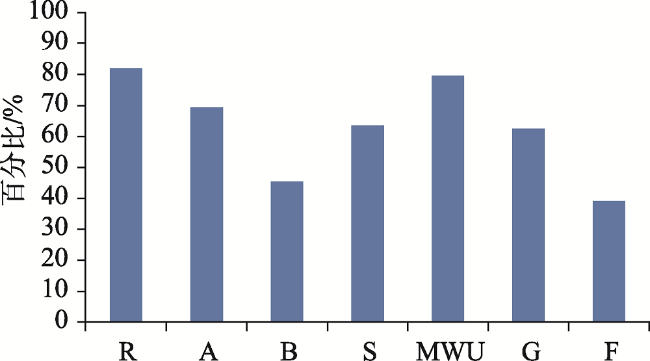
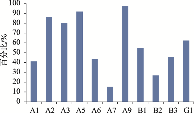
图4 武汉市地理国情监测数据与城市建设用地大类的一致性分析Fig. 4 Consistency between the geographical condition monitoring data and the class I data of urban development land in Wuhan |
衷心感谢武汉市测绘研究院提供课题研究的实验数据和帮助,感谢武汉市自然资源和规划局、武汉市规划研究院、武汉市自然资源和规划信息中心对该课题的大力支持,感谢课题组成员薛维、韩雯雯、张月朦、吴家祺、杨晨等同学的积极参与。
| [1] |
王岳 . 重庆市空间规划体系改革实践[J]. 城市规划学刊, 2018(2):50-56.
[
|
| [2] |
谢映, 段宁, 江叶帆 , 等. 机构改革背景下长沙市级空间规划体系探索[J]. 规划师, 2018,34(10):38-45.
[
|
| [3] |
中共中央, 国务院 . 关于建立国土空间规划体系并监督实施的若干意见[M]. 北京: 人民出版社, 2019.
[ The Communist Party of China Central Committee and the State Council. A guideline on establishing a national territory spatial planning system and supervision of its implementation[M]. Beijing: People's Publishing House, 2019. ]
|
| [4] |
中华人民共和国自然资源部. 关于全面开展国土空间规划工作的通知[EB/OL]. http://gi.mnr.gov.cn/201905/t20190530_2439129.html2019-05-28.
[ Ministry of Natural Resources of the People's Republic of China, Guidelines on comprehensively carrying out national territory spatial planning[EB/OL]. http://gi.mnr.gov.cn/201905/t20190530_2439129.html2019-05-28.]
|
| [5] |
陈俊勇 . 地理国情监测的学习札记[J]. 测绘学报, 2012,41(5):633-635.
[
|
| [6] |
李德仁, 马军, 邵振峰 . 论地理国情普查和监测的创新[J]. 武汉大学学报·信息科学版, 2018,43(1):1-9.
[
|
| [7] |
李德仁, 丁霖, 邵振峰 . 关于地理国情监测若干问题的思考[J]. 武汉大学学报·信息科学版, 2016,41(2):143-147.
[
|
| [8] |
方灿莹, 胡秀娟, 徐涵秋 , 等. 不同城市规划的生态质量差异对比研究[J]. 地球信息科学学报, 2017,19(8):1097-1107.
[
|
| [9] |
罗名海 . 武汉市地理国情监测的总体任务与有关思考[J]. 地理空间信息, 2017,15(2):6-8.
[
|
| [10] |
乔朝飞 . 国外地理国情监测概况与启示[J]. 测绘通报, 2011(11):81-83.
[
|
| [11] |
巩垠熙, 王莺, 梁敏 , 等. 地理国情信息支撑下的空间开发适宜性评价[J]. 测绘通报, 2017(7):66-71.
[
|
| [12] |
余晓敏, 李兵, 詹庆明 , 等. 基于地理国情时空数据的城市建成区动态监测[J]. 地理空间信息, 2015(6):8-11.
[
|
| [13] |
吴正鹏 . 基于地理国情数据的天津滨海新区建成区动态监测[J]. 测绘通报, 2016(S2):254-257.
[
|
| [14] |
杨伯钢, 王淼, 刘博文 . 面向城市规划决策的地理国情数据挖掘——以北京市城市规模模拟为例[J]. 测绘通报, 2017(S2):141-145.
[
|
| [15] |
郭雷, 胡婵娟, 高红莉 , 等. 基于地理国情普查数据的郑州市海绵城市建设途径研究[J]. 中国人口·资源与环境, 2018,28(S1):37-40.
[
|
| [16] |
程滔, 周旭, 郑新燕 , 等. 地理国情监测水面数据时空一致性优化方法[J]. 地球信息科学学报, 2018,20(9):1216-1224.
[
|
| [17] |
张凤瑞 . 地理国情与城市总体规划评估用地分类体系衔接探讨[J]. 测绘通报, 2016(5):116-119.
[
|
| [18] |
马世发, 邹威, 欧阳雪敏 . 三生协调的地理国情综合统计分析框架设计[J]. 测绘科学, 2017(10):80-87.
[
|
| [19] |
郑志宏 . 空间规划底图数据编制与数据库建设探讨[J]. 测绘通报, 2018(7):126-128.
[
|
| [20] |
桂德竹, 王硕, 张成成 . “多规合一”空间规划底图编制方法[J]. 测绘与空间地理信息, 2016,39(8):20-23.
[
|
| [21] |
李双林, 彭清山 . 武汉市用地现状遥感综合调查及数字化建库[J]. 测绘通报, 1997(10):13-15.
[
|
| [22] |
肖继春 . 重庆市城市用地现状遥感调查研究[J]. 国土资源遥感, 1995,7(2):7-14.
[
|
| [23] |
中华人民共和国住房和城乡建设部. 城市用地分类与规划建设用地标准[S]. 北京: 中国建筑工业出版社, 2012.
[ Ministry of Housing and Urban-Rural Construction of the People's Republic of China. Code for classification of urban land use and planning standards for development land[S]. Beijing: China Construction Industry Press, 2012. ]
|
| [24] |
中华人民共和国住房和城乡建设部. 城乡用地分类与规划建设用地标准(征求意见稿)[S]. 北京: 中国建筑工业出版社, 2018.
[ Ministry of Housing and Urban-Rural Construction of the People's Republic of China. Code for classification of urban and rural land use and planning standards of development land(Draft)[S]. Beijing: China Construction Industry Press, 2018. ]
|
| [25] |
黄坤赤, 时晓燕 . 面向深圳市的土地用途分类思考——一个整合我国土地利用分类体系的思路[J]. 中国土地科学, 2001(06):33-38.
[
|
| [26] |
曹传新 . 对《城市用地分类与规划建设用地标准》的透视和反思[J]. 规划师, 2002(10):58-61.
[
|
| [27] |
宁津生, 王正涛 . 2012-2013年测绘学科发展综合报告[J]. 测绘科学, 2014,39(2):3-10.
[
|
| [28] |
郭冬娥, 江娜, 郭永亮 . 地理国情普查数据在土地监管中的初步应用研究[J]. 测绘通报, 2015(7):75-78.
[
|
| [29] |
国务院第一次全国地理国情普查领导小组办公室. 地国情普查内容与指标[M]. 北京: 测绘出版社, 2013.
[ Leading Group Office of China's First National Geographic Conditions Census of the State Council. Contents and indexes of national geographic conditions census[M]. Beijing: Surveying and Mapping Press, 2013. ]
|
| [30] |
廖琦, 苏墨, 罗罡辉 , 等. 面向规划国土数据融合的深圳市土地利用分类体系研究[J]. 中国土地科学, 2014(5):58-64.
[
|
| [31] |
刘彤起, 赵要伟, 刘雷 , 等. 空间治理现代化下的长春市空间规划总图探索[J]. 规划师, 2017,33(S2):51-55.
[
|
| [32] |
中华人民共和国国土资源部. 土地利用现状分类[S]. 北京: 中国标准出版社, 2017.
[ Ministry of Land and Resources of the People's Republic of China. Classification of land use[S]. Beijing: Standards Press of China, 2017. ]
|
/
| 〈 |
|
〉 |