
居住区典型地物热环境的日变化及其相互影响分析
|
孙 杰(1994— ),男,安徽阜阳人,硕士,主要从事遥感方向的研究。E-mail: 18811787078@163.com |
收稿日期: 2019-05-31
要求修回日期: 2019-11-18
网络出版日期: 2020-04-13
基金资助
国家重点研发计划项目(2018YFC0809900)
国家重点研发计划项目(2018YFC0706004)
版权
Diurnal Variation and Mutual Influence of Typical Ground Objects' Thermal Environment in Residential Areas
Received date: 2019-05-31
Request revised date: 2019-11-18
Online published: 2020-04-13
Supported by
National Key Research and Development Program of China(2018YFC0809900)
National Key Research and Development Program of China(2018YFC0706004)
Copyright
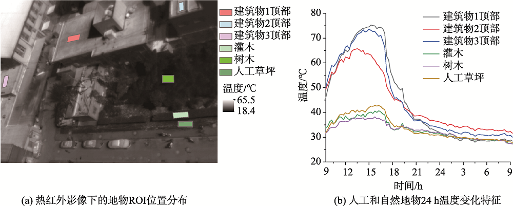
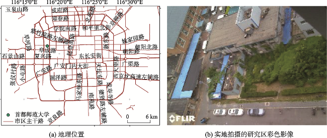
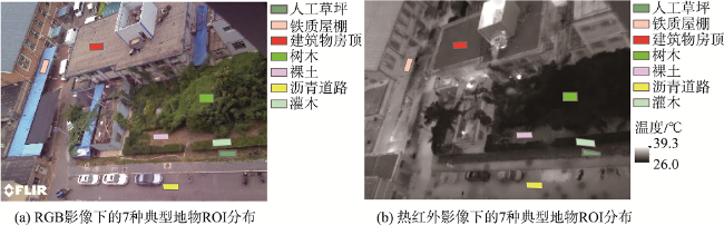
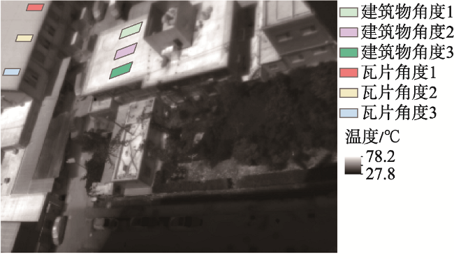
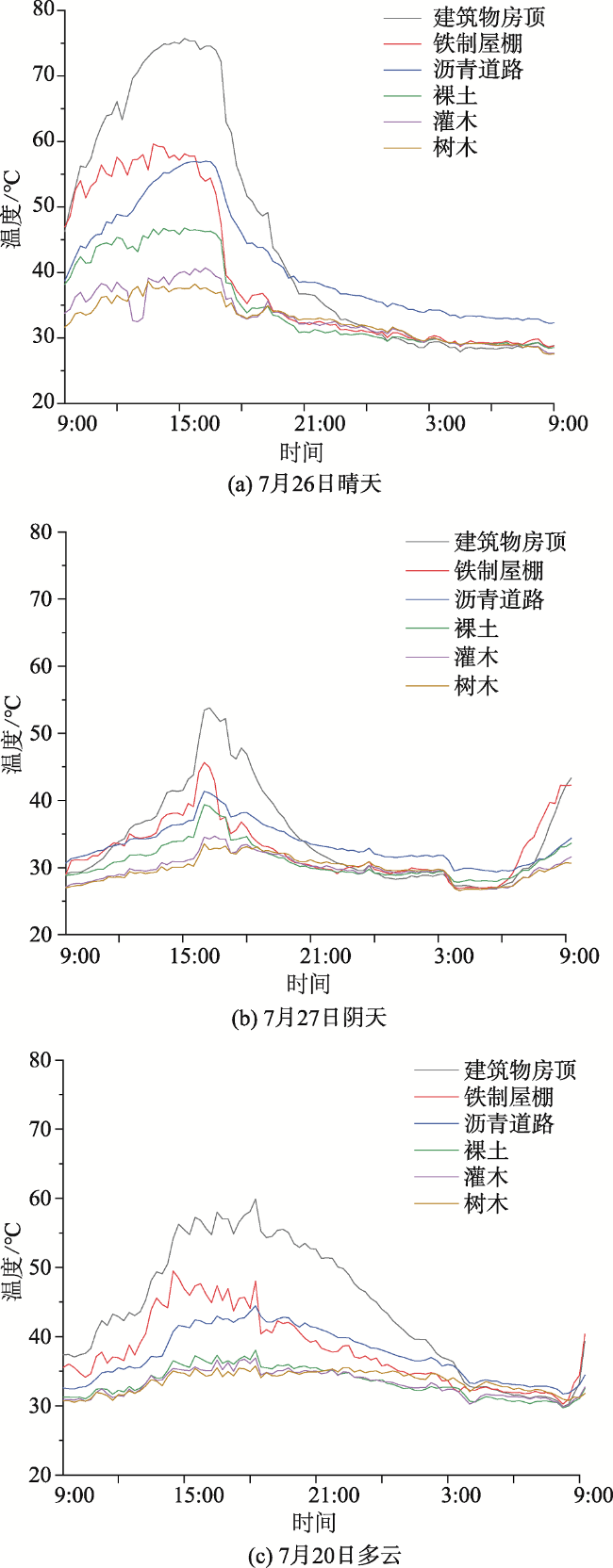
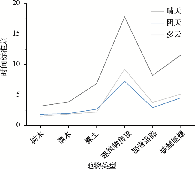
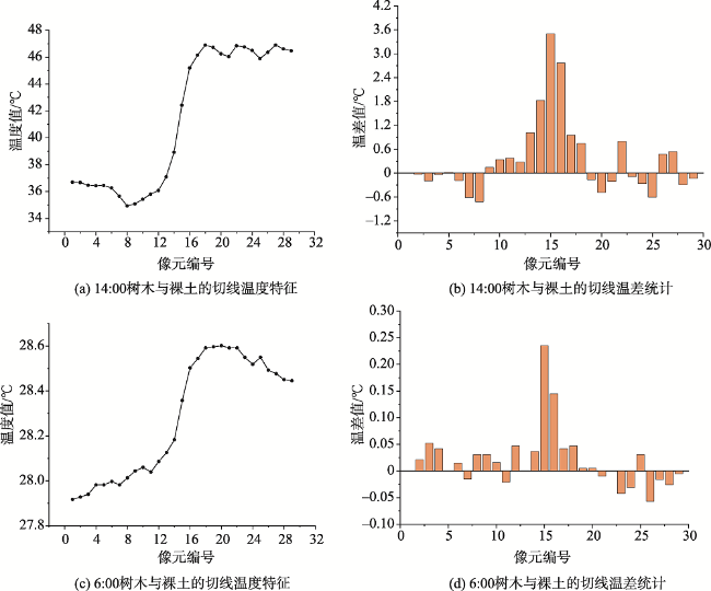
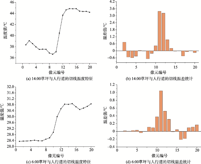
居住区热环境状况是影响局地微气候变化的重要因素,研究居住区地物的热环境特征,对于了解和改善微气候具有重要意义。为了更好地揭示居住区热环境特征,本研究使用热红外成像仪对北京市某校园居住区进行观测,获取了夏季不同天气状况下(晴天、阴天、多云)的24 h热红外影像数据。依据各天气数据和地物属性,系统分析了各地物日变化规律,并通过垂线法判定邻近地物的温度边界范围,进而揭示出地物间温度交互特征。结果如下:① 太阳辐射是影响地物白天温度变化的主要因素,与地物温度呈正相关性;在多云天气下,地物的最高温度滞后至16:00出现,且地物温度曲线呈现连续的“锯齿状”升降趋势,云层的大量运动是导致多云天气下的地物温度波动变化的关键因素;沥青道路在夜间的温度均高于其他地物,并且夜间持续放热,提生周围环境温度;阴影能够有效减少地物吸收的太阳辐射量,降低地物表面温度;植被的冠层厚度与地物温度呈负相关性,因此增加居住区内绿植的冠层厚度,增大区域阴影面积有助于改善局地微气候;② 树木和裸土在06:00和14:00的温度交互作用强烈,表明在地物交界处,全天持续发生显著的热量交换;而夜间至凌晨,草坪与人行道持续进行热量交换,帮助降低路面温度,缓解周围高温状况。
孙杰 , 毛智慧 , 王乐 , 邓磊 . 居住区典型地物热环境的日变化及其相互影响分析[J]. 地球信息科学学报, 2020 , 22(2) : 279 -289 . DOI: 10.12082/dqxxkx.2020.190289
Along with acceleration urbanization, the urban heat island effect is increasingly intensifying due to urban construction. In particular, the thermal environment of residential areas has a profound influence on the local micro-climate. Therefore, studying the thermal environment characteristics of residential areas is of great significance for understanding and improving the local micro-climate. To reveal the thermal environment characteristics of residential areas, this study focused on a residential area in a campus of Beijing by using thermal infrared imagery, and obtained 24 hours thermal infrared data under different weather conditions (clear sky, cloudy, overcast sky) in summer, then selected typical urban ground objects (buildings, iron sheds, asphalt roads, bare soil, trees and shrubs, etc.), and systematically analyzed the diurnal variations of objects in different regions. Finally, the interactive features of the ground objects' temperature were revealed by using a tangent method to determine the boundary ranges of the ground objects. The main results are as follows: (1) The surface temperature curve of artificial ground objects (such as buildings and iron sheds) shows continuously violent ups and downs because of the dramatic changes of solar radiation. It indicates that solar radiation is the main factor affecting the temperature change of ground objects during the daytime, with positive correlation with the temperature of ground objects. In the cloudy weather, the maximum temperature of ground objects occurs after 16:00. Cloud movement increases the temperature fluctuation of ground objects, especially in the cloudy weather. Asphalt roads have higher temperatures at night than other ground objects, and continue to radiate heat at night resulting in ambient temperature increases. Shadow could effectively reduce the amount of solar radiation absorbed by ground objects and reduce the surface temperature. Vegetation canopy thickness is negatively correlated with the temperature of ground objects. Therefore, in residential areas, increasing the vegetation canopy thickness and expanding shadow areas will improve the local micro-climate. (2) The strong temperature interaction between trees and bare soil at 06:00 and 14:00 indicates that significant heat exchange occurs throughout the day at the junction of ground objects. At 06:00, the temperature at the junction of lawn and sidewalk has a significant interaction, indicating that there is heat exchange between the lawn and the pavement from night to early morning. It helps relieve the high temperature of the road and the surrounding environment.
表1 FLIR T440 热像仪参数Tab. 1 Parameter setting of the FLIR T440 thermal imaging camcorder |
| 仪器 | FLIR T440 |
|---|---|
| 红外分辨率/像素 | 320×240 |
| 波长范围/μm | 7.5~13 |
| 视场角(FOV)/° | 45 |
| 测量温度范围/℃ | -20~1200 |
| 最小焦距/m | 0.4 |
| 发射率 | 0.95 |
| 热灵敏度/℃ | <0.045 |
| [1] |
|
| [2] |
叶丽梅, 江志红, 霍飞 . 南京地区下垫面变化对城市热岛效应影响的数值模拟[J]. 大气科学学报, 2014,37(5):642-652.
[
|
| [3] |
|
| [4] |
|
| [5] |
肖荣波, 欧阳志云, 李伟峰 , 等. 城市热岛的生态环境效应[J]. 生态学报, 2005,25(8):2055-2060.
[
|
| [6] |
白杨, 王晓云, 姜海梅 , 等. 城市热岛效应研究进展[J]. 气象与环境学报, 2013,29(2):101-106.
[
|
| [7] |
李海峰, 李永树, 卢正 , 等. 河流廊道景观的热环境效应分析[J]. 地理与地理信息科学, 2015,31(4):51-54.
[
|
| [8] |
|
| [9] |
寿亦萱, 张大林 . 城市热岛效应的研究进展与展望[J]. 气象学报, 2012,70(3):338-353.
[
|
| [10] |
刘宇鹏, 杨波, 陈崇 . 基于遥感的长沙市城市热岛效应时空分析[J]. 遥感信息, 2011(6):73-78.
[
|
| [11] |
闫峰, 覃志豪, 李茂松 , 等. 基于MODIS数据的上海市热岛效应研究[J]. 武汉大学学报·信息科学版, 2007,32(7):576-580.
[
|
| [12] |
|
| [13] |
|
| [14] |
|
| [15] |
周甜甜, 廉丽姝, 李宝富 , 等. 基于遥感的青岛市城市热岛时空变化特征[J]. 地球环境学报, 2017,8(2):157-168.
[
|
| [16] |
|
| [17] |
商茹, 李嘉乐, 李薇 , 等. 北京城市绿地不同下垫面对环境微气候影响研究[J]. 中国农学通报, 2019,35(22):77-83.
[
|
| [18] |
|
| [19] |
|
| [20] |
杨雅君, 邹振东, 赵文利 , 等. 6种城市下垫面热环境效应对比研究[J]. 北京大学学报(自然科学版), 2017,53(5):881-889.
[
|
| [21] |
吴志丰, 王业宁, 孔繁花 , 等. 基于热红外影像数据的典型居住区常见地表类型热特征分析[J]. 生态学报, 2016,36(17):5421-5431.
[
|
| [22] |
邹晓泉, 钟珂, 张红婴 , 等. 风速风向对上海地区建筑物南墙冬季太阳辐射得热的影响[J]. 东华大学学报(自然科学版), 2017,43(1):102-108.
[
|
| [23] |
孟鹏燕, 徐元进, 陈曦 . 地形对热红外数据反演林地表面温度的影响[J]. 地理与地理信息科学, 2015,31(1):32-36.
[
|
| [24] |
何文英, 陈洪滨, 宣越健 , 等. 几种地表微波比辐射率变化特征的地面观测[J]. 地球物理学进展, 2010,25(6):1983-1993.
[
|
| [25] |
徐静, 王新生, 高守杰 , 等. 地物比辐射率数据分析[J]. 遥感技术与应用, 2013,28(5):815-823.
[
|
| [26] |
黄良美, 黄海霞, 项东云 , 等. 南京市四种下垫面气温日变化规律及城市热岛效应[J]. 生态环境学报, 2007,16(5):1411-1420.
[
|
/
| 〈 |
|
〉 |


