
DEM分辨率对黄土侵蚀沟形态特征表达的不确定性分析
|
李思进(1996— ),男,山东济宁人,博士生,主要从事研究DEM数字地形分析研究。E-mail:lisijin1411@163.com |
收稿日期: 2019-07-03
要求修回日期: 2019-12-05
网络出版日期: 2020-05-18
基金资助
国家自然科学基金项目(41930102)
国家自然科学基金项目(41971333)
江苏高校优势学科建设工程资助项目
版权
Uncertainty of the Morphological Feature Expression of Loess Erosional Gully Affected by DEM Resolution
Received date: 2019-07-03
Request revised date: 2019-12-05
Online published: 2020-05-18
Supported by
National Natural Science Foundation of China(41930102)
National Natural Science Foundation of China(41971333)
Priority Academic Program Development of Jiangsu Higher Education Institutions
Copyright
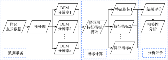
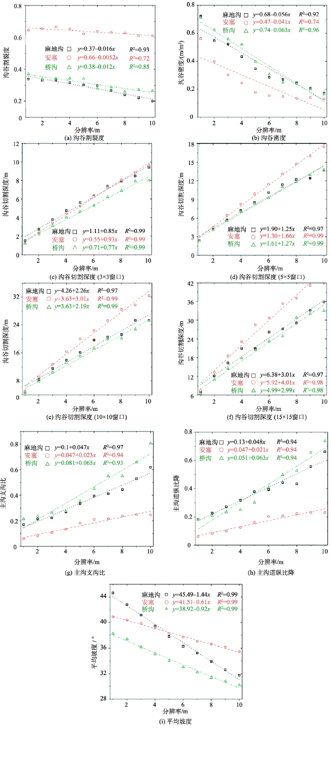
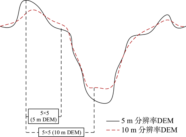
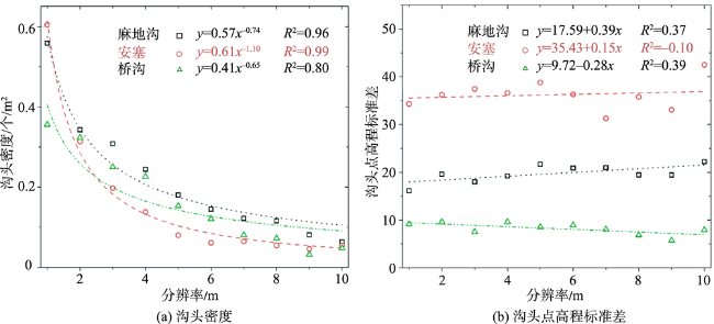
黄土侵蚀沟的地形表达是开展黄土沟谷侵蚀研究的基础工作,利用数字高程模型(DEM)定量描述侵蚀沟特征有助于研究侵蚀沟的形态变化和发育过程。基于DEM数据计算多种指标对黄土侵蚀沟特征进行描述是目前侵蚀沟研究中最为常用的方法。但是,受到格网DEM数据结构的限制,其计算结果会存在一定的不确定性。在侵蚀沟地形表达时,对形态特征的表达会受到DEM数据分辨率的影响,进而造成表达结果的不确定性。尤其在黄土高原地区,地形特征更为破碎,地形要素更为复杂,其表达结果受DEM分辨率的影响更为明显。本文以黄土高原典型样区为例,基于点云数据建立不同分辨率的DEM数据集,通过不同地形因子对侵蚀沟特征进行表达,分析DEM分辨率在黄土侵蚀沟形态特征表达时的不确定性。结果显示,分辨率的降低对主沟支沟比和纵比降等侵蚀沟形态特征因子产生了较大影响,且指标与分辨率多呈现线性变化关系。但是,随着侵蚀沟的横向扩张,DEM分辨率对其特征表达的影响逐渐被削弱。此外,在使用固定分析窗口进行侵蚀沟特征计算时,由于分辨率的降低,格网尺寸增大,其实际分析半径随之增大,使得计算范围内地表形态变化增加,导致沟谷切割深度随着分辨率的降低反而增加。同时,侵蚀沟主沟道区域受分辨率影响较小,沟头区域指标与分辨率的关系较弱。
李思进 , 代文 , 熊礼阳 , 汤国安 . DEM分辨率对黄土侵蚀沟形态特征表达的不确定性分析[J]. 地球信息科学学报, 2020 , 22(3) : 338 -350 . DOI: 10.12082/dqxxkx.2020.190352
Terrain expression of loess erosional gully is the base of the researches of gully erosion modeling and prediction, which also have a great significance in related fields of geoscience. The quantitative study of gully features based on Digital Elevation Model (DEM) can contribute to the research of morphological change and formation process of erosional gully. Currently, the use of representative feature indicators to describe the morphology of loess erosional gully should be one of the most popular used methods in researches of erosional gully. However, due to the structural limitation of grid DEM, the uncertainty widely exists in the calculated results based on DEMs. In previous practical researches, it has been proved that the resolution of DEM is an important factor which can influence experimental results obviously and cause the uncertainty of feature derivatives. Especially in the area of the Loess Plateau, the fractured landform and complicated landscape elements influence the expression of morphological features. Thus, the impact of DEM's resolution are more obvious in this area. The aim of this study is to analyze the uncertainty of morphological feature expression in the Loess Plateau based on DEMs with different resolutions. In this paper, DEMs with various resolutions of three study areas in the Loess Plateau were established based on the point cloud data which were acquired by Unmanned Aerial Vehicle (UAV). Eight typical morphological indicators were selected and calculated based on DEMs. These indicators were divided into groups according to the definition of each indicator. Two groups were established to express the morphological features of gully channel and gully head respectively. The experimental results shown that DEM's resolution has great influences on morphological feature indicators of erosional gully, and the major relationships between indicators and resolutions are linear. The high development stage of erosional gully's horizontal extension can weaken the influence of DEM’s resolution on morphological feature expression. In addition, when using fixed-size windows to calculate morphological feature indicators of erosional gully, the decrease of DEM's resolution lead to the increase of actual analysis radius and then surface morphological change has a growth trend in calculation areas. This phenomenon results in the rise of gully cutting depth when using DEM with lower resolution. Besides, the main gully channel is less affected by resolution. Thus, the DEM data with low resolution can be used to calculate morphological features of main gully channel. Finally, the morphological indicators of gully head were analyzed and there are weak correlations between these indicators and the resolution of DEM.
表1 各样区沟谷网络提取适宜阈值Tab. 1 The appropriate threshold value for gully network extraction of sample areas (m) |
| 样区 | ||||||||||
|---|---|---|---|---|---|---|---|---|---|---|
| 1 | 2 | 3 | 4 | 5 | 6 | 7 | 8 | 9 | 10 | |
| 麻地沟 | 350 | 200 | 100 | 80 | 70 | 60 | 50 | 40 | 40 | 40 |
| 安塞 | 350 | 200 | 150 | 120 | 100 | 100 | 80 | 70 | 60 | 50 |
| 桥沟 | 350 | 150 | 100 | 80 | 80 | 70 | 60 | 50 | 50 | 50 |
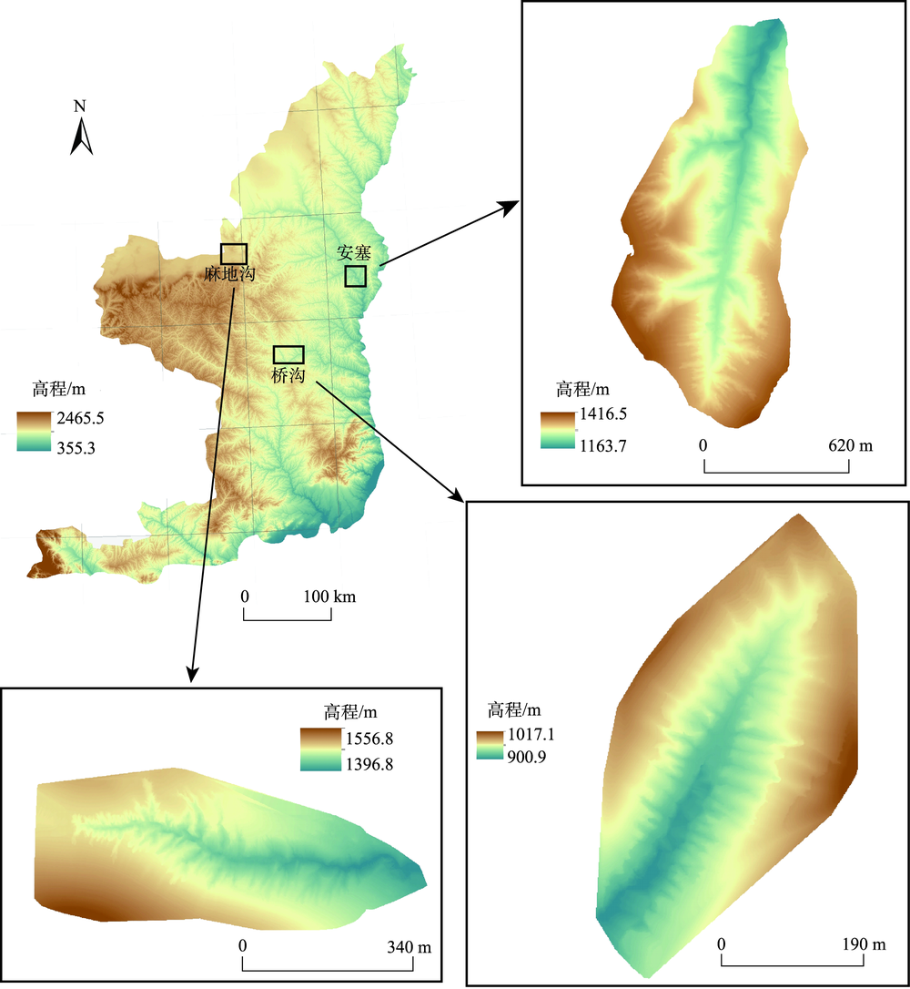
表2 样区基本信息及特征概述Tab. 2 Basic information and features of study areas |
| 样区 | 位置 | 面积/km2 | 海拔/m | 侵蚀沟特点 |
|---|---|---|---|---|
| 安塞 | 37°14'24"N—37°14'27"N,109°14'41"E—109°14'53"E | 0.50 | 1163.7~1416.5 | 主沟道呈东西走向,南面浅沟和切沟发育多,北面下切侵蚀强烈,发育3条较大的切沟,较少发育浅沟 |
| 麻地沟 | 37°28'59"N—37°28'49"N,108°48'2"E—108°48'35"E | 0.23 | 1396.8~1556.8 | 主沟道呈南北走向,浅沟和切沟发育较多 |
| 桥沟 | 37°34'10"N—37°34'16"N,104°16'49"E—104°16'57"E | 0.13 | 900.9~1017.1 | 主沟道呈西南—东北走向,两侧发育有较多浅沟和切沟 |
| [1] |
景可 . 黄土高原沟谷侵蚀研究[J]. 地理科学, 1986,6(4):340-347.
[
|
| [2] |
陈永宗 . 黄土高原土壤侵蚀规律研究工作回顾[J]. 地理研究, 1987,6(1):76-85.
[
|
| [3] |
刘秉正, 吴发启 . 黄土塬区沟谷侵蚀与发展[J]. 西北林学院学报, 1993(2):7-15.
[
|
| [4] |
罗来兴 . 划分晋西、陕北、陇东黄土区域沟间地与沟谷的地貌类型[J]. 地理学报, 1956,23(3):201-222.
[
|
| [5] |
陈浩, 方海燕, 蔡强国 , 等. 黄土丘陵沟壑区沟谷侵蚀演化的坡向差异——以晋西王家沟小流域为例[J]. 资源科学, 2006,28(5):176-184.
[
|
| [6] |
刘秉正, 翟明柱, 吴法啟 . 渭北高原沟谷侵蚀初探[J]. 水土保持研究, 1990(2):25-33.
[
|
| [7] |
谢振乾 . 陕西渭南黄土台塬区沟谷侵蚀作用的初步研究[J]. 陕西地质, 1994(2):56-63.
[
|
| [8] |
|
| [9] |
何雨, 贾铁飞, 李容全 . 黄土丘陵区沟谷发育及其稳定性评价[J]. 干旱区地理, 1999,22(2):64-70.
[
|
| [10] |
严宝文, 李靖, 包忠谟 . 黄土沟谷下蚀趋势评价的指标体系研究[J]. 水土保持学报, 2001,15(1):122-125.
[
|
| [11] |
段家朕 . 基于DEM的晋西北地区黄土沟谷不对称特征研究[D]. 南京:南京师范大学, 2017.
[
|
| [12] |
汤国安, 那嘉明, 程维明 . 我国区域地貌数字地形分析研究进展[J]. 测绘学报, 2017,46(10):1570-1591.
[
|
| [13] |
晏实江, 汤国安, 李发源 , 等. 利用DEM边缘检测进行黄土地貌沟沿线自动提取[J]. 武汉大学学报·信息科学版, 2011,36(3):363-367.
[
|
| [14] |
宋效东, 汤国安, 周毅 , 等. 基于并行GVF Snake模型的黄土地貌沟沿线提取[J]. 中国矿业大学学报, 2013,42(1):134-140.
[
|
| [15] |
李俊, 汤国安, 张婷, 等. 利用DEM提取陕北黄土高原沟谷网络的汇流阈值研究[J]. 水土保持通报, 2007(2):75-78.
[
|
| [16] |
|
| [17] |
|
| [18] |
|
| [19] |
张维 . 基于DEM的陕北黄土高原流域剖面谱研究[D]. 南京:南京师范大学, 2011.
[
|
| [20] |
张肃 . 无人机航摄生成DEM的高程点快速提取算法[J]. 西部资源, 2019(2):146-148,150.
[
|
| [21] |
李永树 . 基于无人机技术的地形图测绘研究[J]. 测绘, 2011,34(4):147-151.
[
|
| [22] |
谢轶群, 朱红春, 汤国安 , 等. 基于DEM的沟谷特征点提取与分析[J]. 地球信息科学学报, 2013,15(1):61-67.
[
|
| [23] |
江岭, 凌德泉, 赵明伟 , 等. 顾及多分析尺度的地形部位面向对象分类方法[J]. 地球信息科学学报, 2018,20(3):281-290.
[
|
| [24] |
|
| [25] |
陈楠, 王钦敏, 汤国安 . 黄土高原坡向信息量变化与DEM分辨率的关系[J]. 高技术通讯, 2008,18(5):525-530.
[
|
| [26] |
|
| [27] |
|
| [28] |
|
| [29] |
汤国安, 赵牡丹, 李天文 , 等. DEM提取黄土高原地面坡度的不确定性[J]. 地理学报, 2003,58(6):824-830.
[
|
| [30] |
|
| [31] |
|
| [32] |
王轲 . 基于古城遗址信息的黄土沟壑演化模拟研究[D]. 南京:南京师范大学, 2017.
[
|
| [33] |
|
| [34] |
|
| [35] |
|
| [36] |
周毅, 汤国安, 习羽 , 等. 引入改进Snake模型的黄土地形沟沿线连接算法[J]. 武汉大学学报·信息科学版, 2013,38(1):82-85.
[
|
| [37] |
|
| [38] |
刘玮, 李发源, 熊礼阳 , 等. 基于区域生长的黄土地貌沟沿线提取方法与实验[J]. 地球信息科学学报, 2016,18(2):220-226.
[
|
| [39] |
王轲, 王琤, 张青峰 , 等. 地形开度和差值图像阈值分割原理相结合的黄土高原沟沿线提取法[J]. 测绘学报, 2015,44(1):67-75.
[
|
| [40] |
|
| [41] |
|
| [42] |
李精忠, 艾廷华, 柯舒 . DEM提取谷地线的有效汇水量阈值范围[J]. 武汉大学学报·信息科学版, 2012,37(10):1244-1247.
[
|
| [43] |
|
| [44] |
常瑞雪 . 基于沟沿线的黄土高原沟蚀程度评价及分区研究[D]. 南京:南京师范大学, 2015.
[
|
| [45] |
李晨瑞 . 基于地形特征要素的黄土沟谷发育及区域差异性研究[D]. 南京:南京师范大学, 2018.
[
|
| [46] |
|
| [47] |
刘增文, 李雅素 . 黄土残塬区侵蚀沟道分类研究[J]. 中国水土保持, 2003,9:32-34,50.
[
|
| [48] |
江岭, 汤国安, 赵明伟 , 等. 顾及地貌结构特征的黄土沟头提取及分析[J]. 地理研究, 2013,32(11):2153-2162.
[
|
| [49] |
朱显谟 . 黄土区土壤侵蚀的分类[J]. 土壤学报, 1956(2):99-115.
[
|
| [50] |
|
| [51] |
|
/
| 〈 |
|
〉 |
