
资源三号卫星DEM数据与全球开放DEM数据的误差对比
|
赵尚民(1982— ),男,河南洛阳人,博士,副教授,主要从事数字地形地貌与生态环境遥感研究。E-mail:zhaoshangmin@tyut.edu.cn |
收稿日期: 2019-11-05
要求修回日期: 2019-12-25
网络出版日期: 2020-05-18
基金资助
山西省自然科学基金项目(201901D111098)
国家重点研发计划项目(2017YFB0503603)
国家自然科学基金项目(41771443)
国家自然科学基金项目(41421001)
国家自然科学基金项目(41590845)
版权
Error Comparison among the DEM Datasets Made from ZY-3 Satellite and the Global Open Datasets
Received date: 2019-11-05
Request revised date: 2019-12-25
Online published: 2020-05-18
Supported by
Natural Science Foundation of Shanxi Province(201901D111098)
National Key Research and Development Program of China(2017YFB0503603)
National Natural Science Foundation of China(41771443)
National Natural Science Foundation of China(41421001)
National Natural Science Foundation of China(41590845)
Copyright
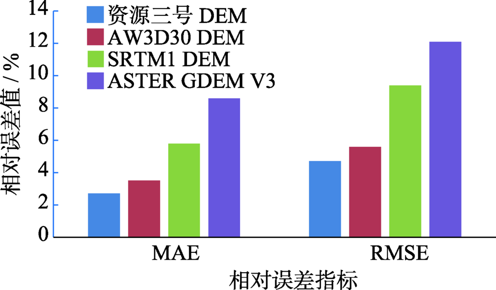
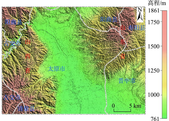
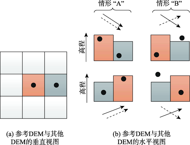
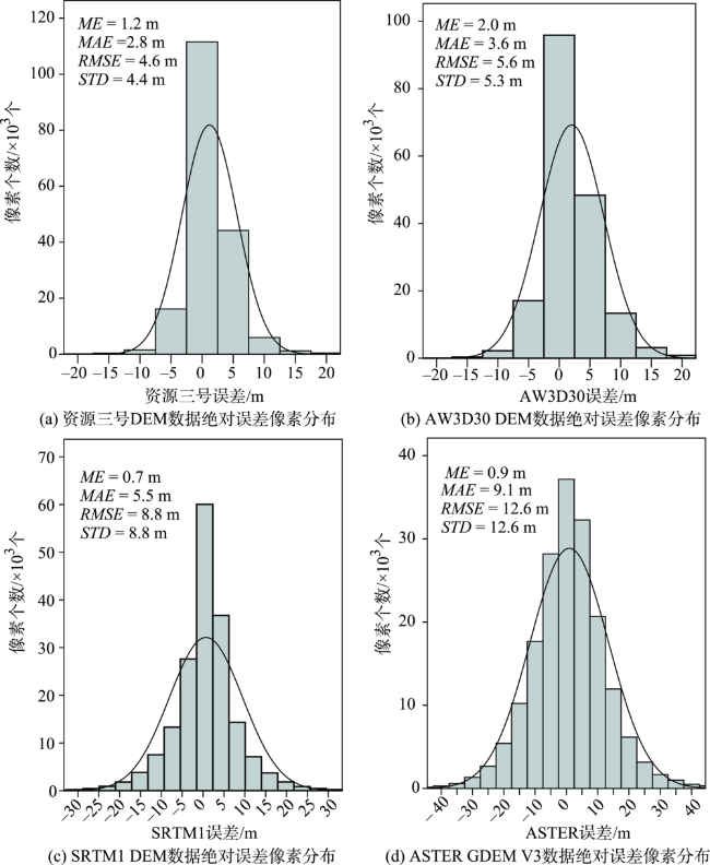
全球开放DEM数据为数字地形分析提供了重要数据源。与已有的全球开放DEM数据相比,资源三号卫星具有更高的空间分辨率、更大的覆盖范围和更好的现势性。将资源三号卫星生成的DEM数据与全球开放DEM数据进行误差对比则为基于资源三号卫星的全球DEM数据研制提供科学依据。本文以山西省中部太原市为研究区,基于高精度激光点云数据生成DEM为参考数据,对资源三号卫星影像生成的DEM数据与全球典型的开放DEM数据(AW3D30、SRTM1和ASTER GDEM)的误差进行了对比分析,并获得了其在不同坡度等级下绝对误差与相对误差的平均值、平均绝对值、均方根值和标准偏差值。研究结果表明:① 4种DEM数据的误差分布均具有较好的对称性。同时,平均误差接近于0 m,SRTM1和ASTER GDEM数据更是如此。因此均方根误差值与标准偏差值近似一致;② 资源三号DEM具有最高的精度,误差最小(均方根误差4.6 m)。其次为AW3D30数据(均方根误差5.6 m)和SRTM1数据(均方根误差8.8 m)。ASTER GDEM数据误差最大(均方根误差12.6 m),精度最差;③ 资源三号DEM、SRTM1和ASTER GDEM数据的误差均随坡度的变大而增大,而AW3D30数据误差随着坡度增加呈现先减小后增大的趋势。总体上,与其他3种DEM数据相比,资源三号DEM在所有坡度范围均具有最小的误差值。
赵尚民 , 程维明 , 蒋经天 , 沙文娟 . 资源三号卫星DEM数据与全球开放DEM数据的误差对比[J]. 地球信息科学学报, 2020 , 22(3) : 370 -378 . DOI: 10.12082/dqxxkx.2020.190658
Global open DEM datasets provide important data sources for digital topographic analysis. Compared to the existing global open DEM datasets, the DEM data made from ZY-3 Satellite have higher spatial resolution, wider coverage and better currency, which results to a great likelihood to produce a global DEM dataset with high quality from ZY-3 Satellite. So the error comparison among the DEM datasets made from ZY-3 Satellite and the global open datasets will provide scientific basis for the global DEM dataset production made form ZY-3 Satellite data. Taking the Taiyuan City (the middle region of Shanxi Province) as a test area, this paper made an error comparison among the DEM datasets made from ZY-3 Satellite (ZY-3 Satellite DEM) and three typical global open DEM datasets (AW3D30, SRTM1 and ASTER GDEM) based on the referencing DEM data produced by laser-point cloud data with high accuracy. Meanwhile, the mean value, mean absolute value, root mean square value and standard deviation value are computed for the absolute error and the relative error at different slope classes. The research results show: (1) the error distributions for all of the four DEM datasets show relatively good symmetry. Meanwhile, the mean error value is approximate to 0 m, especially for the SRTM1 and ASTER GDEM data. So the root mean square error values and the standard deviation error values are approximate for all the four DEM datasets. (2) ZY-3 Satellite DEM has the lowest root mean square error value (4.6 m), so it has the highest accuracy. The next is the AW3D30 data (with root mean square error value of 5.6 m), then the SRTM1 data (with root mean square error value of 8.8 m). ASTER GDEM has the highest error values (with root mean square error value of 12.6 m), so it has the lowest accuracy. Meanwhile, the relative error and the absolute error show similar rules for the four DEM datasets. (3) The errors of the ZY-3 Satellite DEM, SRTM1 and ASTER GDEM data rise with slope increasing. The error of AW3D30 data shows an undulation tendency of rising first, and then falling with slope increasing. The error for the AW3D30 data is lower than that for the SRTM1 data at any slope classes except for the 0°~2° class. At all the slope classes, ASTER GDEM data has the highest error values of all. Overall, compared to other three DEM datasets, ZY-3 Satellite DEM data has the lowest error values and the highest accuracy at all the slope classes.
Key words: ZY-3 Satellite DEM; global open DEM datasets; absolute error; relative error; slope; AW3D30; SRTM1; ASTER GDEM; Taiyuan City
表1 各种DEM数据简介Tab. 1 Brief Introduction to the DEM datasets in this research |
| DEM数据 | 空间分辨率/m | 精度*/m | 获取时间/年 | 覆盖范围 |
|---|---|---|---|---|
| 参考DEM | 5 | 0.15 | 2014 | 太原市及周边地区 |
| 资源三号DEM | 5 | 8 | 2019 | 南北纬84°之间 |
| AW3D30 DEM | 30 | 3.4 | 2006—2011 | 南北纬82°之间 |
| SRTM1 DEM | 30 | 9 | 2000 | 南北纬60°之间 |
| ASTER GDEM | 30 | 12.6 | 2000—2009 | 南北纬83°之间 |
注:*不同数据源的精度指标不完全一致。 |
表2 4种DEM数据绝对误差在不同坡度等级下的ME、MAE、RMSE和STD值Tab. 2 ME, MAE, RMSE and STD values of theabsolute error for the four DEM datasets at different slope classes (m) |
| DEM数据 | 坡度/° | 0~2 | 2~7 | 7~15 | 15~25 | 25~35 | >35 |
|---|---|---|---|---|---|---|---|
| (控制点数量/个) | (45 259) | (37 131) | (16 301) | (37 594) | (22 065) | (23 936) | |
| ME | 资源三号DEM | 1.5 | 1.1 | 0.7 | 1.0 | 1.2 | 1.3 |
| AW3D30 DEM | 2.3 | 1.8 | 1.2 | 4.6 | 2.1 | 3.0 | |
| SRTM1 DEM | 1.1 | 1.0 | 0.1 | -0.0 | 0.4 | 1.3 | |
| ASTER GDEM V3 | 1.0 | -0.0 | -0.7 | 0.4 | 1.8 | 3.3 | |
| MAE | 资源三号DEM | 2.3 | 2.3 | 2.5 | 2.9 | 3.3 | 3.9 |
| AW3D30 DEM | 3.1 | 2.7 | 2.8 | 3.6 | 4.4 | 5.6 | |
| SRTM1 DEM | 2.5 | 3.5 | 5.4 | 6.8 | 8.0 | 10.1 | |
| ASTER GDEM V3 | 7.0 | 7.1 | 8.6 | 9.9 | 11.3 | 12.6 | |
| RMSE | 资源三号DEM | 3.7 | 3.7 | 4.1 | 4.6 | 6.0 | 5.9 |
| AW3D30 DEM | 5.5 | 4.4 | 4.1 | 4.9 | 6.2 | 8.3 | |
| SRTM1 DEM | 3.8 | 5.5 | 7.6 | 9.2 | 10.9 | 15.4 | |
| ASTER GDEM V3 | 9.5 | 9.7 | 11.4 | 13.0 | 14.9 | 18.4 | |
| STD | 资源三号DEM | 3.4 | 3.5 | 4.1 | 4.5 | 5.9 | 5.7 |
| AW3D30 DEM | 5.0 | 4.1 | 3.9 | 4.6 | 5.8 | 7.8 | |
| SRTM1 DEM | 3.6 | 5.5 | 7.6 | 9.2 | 10.9 | 15.3 | |
| ASTER GDEM V3 | 9.5 | 9.7 | 11.4 | 13.0 | 14.7 | 18.1 |
表3 4种DEM数据相对误差在不同坡度等级下的MAE和RMSE数值Tab. 3 MAEand RMSE values of the relative errorfor the four DEM datasets at different slope classes (%) |
| DEM数据 | 坡度/° | 0~2 | 2~7 | 7~15 | 15~25 | 25~35 | >35 |
|---|---|---|---|---|---|---|---|
| (点对数量/对) | (198 276) | (119 526) | (87 624) | (121 341) | (118 908) | (80 882) | |
| MAE | 资源三号DEM | 1.8 | 2.1 | 2.8 | 3.1 | 3.5 | 4.2 |
| AW3D30 DEM | 2.3 | 2.5 | 3.2 | 3.9 | 4.6 | 6.0 | |
| SRTM1 DEM | 2.2 | 3.5 | 6.0 | 7.4 | 8.7 | 11.2 | |
| ASTER GDEM V3 | 5.6 | 6.3 | 8.2 | 9.8 | 11.4 | 13.6 | |
| RMSE | 资源三号DEM | 3.2 | 3.6 | 4.3 | 5.2 | 5.9 | 6.3 |
| AW3D30 DEM | 4.4 | 4.2 | 4.6 | 5.3 | 6.4 | 8.8 | |
| SRTM1 DEM | 3.5 | 5.8 | 8.6 | 10.1 | 11.9 | 16.3 | |
| ASTER GDEM V3 | 7.7 | 8.7 | 11.1 | 13.0 | 15.0 | 18.5 |
| [1] |
汤国安 . 我国数字高程模型与数字地形分析研究进展[J]. 地理学报, 2014,69(9):1305-1325.
[
|
| [2] |
陈加兵, 李慧, 陈文惠 , 等. 基于DEM 与DLG的福建省地貌形态自动分类[J]. 地球信息科学学报, 2013,15(1):75-80.
[
|
| [3] |
|
| [4] |
|
| [5] |
|
| [6] |
|
| [7] |
|
| [8] |
李振洪, 李鹏, 丁咚 , 等. 全球高分辨率数字高程模型研究进展与展望[J]. 武汉大学学报·信息科学版, 2018,43(12):1927-1942.
[
|
| [9] |
高志远, 谢元礼, 王宁练 , 等. 青藏高原地区3种全球DEM精度对不同地形因子的响应[J]. 水土保持通报, 2019,39(2):184-191.
[
|
| [10] |
张玉伦, 王叶堂 . 低山丘陵区多源数字高程模型误差分析[J]. 遥感技术与应用, 2018,33(6):1112-1121.
[
|
| [11] |
杜小平, 郭华东, 范湘涛 , 等. 基于ICESat/GLAS数据的中国典型区域SRTM与ASTER GDEM高程精度评价[J]. 地球科学·中国地质大学学报, 2013,38(4):887-897.
[
|
| [12] |
|
| [13] |
|
| [14] |
武文娇, 章诗芳, 赵尚民 . SRTM1 DEM 与ASTER GDEM V2 数据的对比分析[J]. 地球信息科学学报, 2017,19(8):1108-1115.
[
|
| [15] |
赵尚民, 何维灿, 王莉 . DEM数据在黄土高原典型地貌区的误差分布[J]. 测绘科学, 2016,41(2):67-70,102.
[
|
| [16] |
|
| [17] |
龚健雅, 王密, 杨博 . 高分辨率光学卫星遥感影像高精度无地面控制精确处理的理论与方法[J]. 测绘学报, 2017,46(10):1255-1261.
[
|
| [18] |
潘红播, 张过, 唐新明 , 等. 资源三号测绘卫星影像产品精度分析与验证[J]. 测绘学报, 2013,42(5):738-744,751.
[
|
| [19] |
|
| [20] |
|
| [21] |
张弛, 葛莹, 王冲 , 等. 资源三号测绘卫星DSM与ASTER GDEM精度对比分析——以高海拔山区为例[J]. 测绘工程, 2016,25(8):29-32,37.
[
|
| [22] |
|
| [23] |
|
| [24] |
周成虎, 程维明, 钱金凯 . 数字地貌遥感解析与制图[M]. 北京: 科学出版社, 2009.
[
|
| [25] |
|
| [26] |
|
| [27] |
李德仁 . 我国第一颗民用三线阵立体测图卫星——资源三号测绘卫星[J]. 测绘学报, 2012,41(3):317-322.
[
|
| [28] |
兰穹穹, 郝雪涛, 齐怀川 . 资源三号卫星影像DEM提取与精度分析[J]. 遥感信息, 2015,30(3):14-18.
[
|
/
| 〈 |
|
〉 |
