
基于地形剖面的黄土塬梁峁地形各向异性奇异强度研究
|
曹建军(1976— ),男,陕西延安人,博士后,主要从事地形空间关系研究。E-mail:jjcao@njnu.edu.cn |
收稿日期: 2019-09-27
要求修回日期: 2019-12-08
网络出版日期: 2020-05-18
基金资助
国家自然科学基金项目(41930102)
国家自然科学基金项目(41871313)
国家自然科学基金项目(41671389)
版权
Study on the Singularity Strength of Topographic Anisotropy of Loess Tableland, Ridge, Hill in Loess Plateau based on Terrain Profile
Received date: 2019-09-27
Request revised date: 2019-12-08
Online published: 2020-05-18
Supported by
National Natural Science Foundation of China(41930102)
National Natural Science Foundation of China(41871313)
National Natural Science Foundation of China(41671389)
Copyright
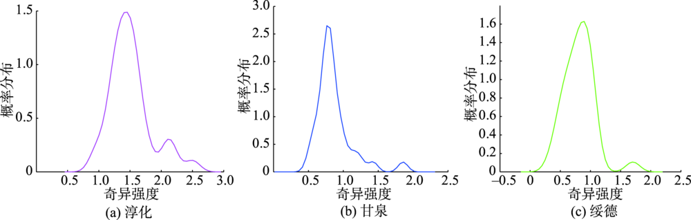
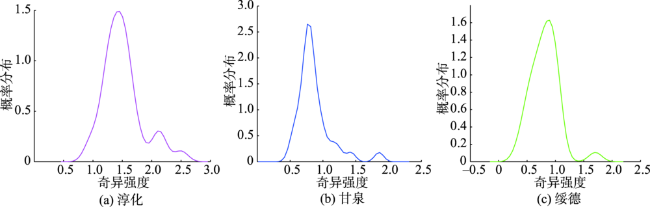
黄土高原不同地貌类型对应的地形起伏变化特征各不相同,地形起伏在不同方向上的变化特征具有很大差异性,即地形各向异性。本文引入多重分形谱参数描述不同地貌类型地形各向异性的变化规律,以反映不同黄土地貌地形各向异性的局部和整体变化格局。本研究以5 m分辨率的DEM数据为基础,选取淳化、甘泉、绥德3个典型黄土塬梁峁地貌类型研究样区,对其地形各向异性的变化特征进行分析。研究表明:①3种黄土地貌类型地形各向异性变化具有显著的多重分形特征,地形各向异性变化的奇异强度由强到弱依次为淳化、绥德、甘泉;②淳化样区地形各向异性奇异强度在1.4的概率最大,在奇异强度为2.2附近又有一个小的峰值,总体以奇异强度1.4为主;③甘泉样区的奇异强度在1.8有一个小的峰值,总体以奇异强度0.7为主;④绥德样区奇异强度为0.8的概率最大,且较为均匀地分布在0.8附近,地形各向异性的概率分布呈现为对称分布。研究结果为黄土塬梁峁地形各向异性变化奇异强度为黄土塬最大,黄土峁次之,黄土梁最小。该研究可为黄土地貌的精确分类提供定量信息支持,为区域水土侵蚀评价提供地形指标。
曹建军 , 汤国安 , 方炫 , 刘永娟 , 那嘉明 , 朱莹 , 李金莲 . 基于地形剖面的黄土塬梁峁地形各向异性奇异强度研究[J]. 地球信息科学学报, 2020 , 22(3) : 442 -451 . DOI: 10.12082/dqxxkx.2020.190555
The characteristics of topographic relief variation are diverse from one landform type to another in the Loess Plateau. Great differences of topographic relief variation exist in different directions, which is known as topographic anisotropy. As fractal theory and geomorphology research become increasingly cooperative, Multifractal Detrended Fluctuation Analysis (MF-DFA) method, an effective means to quantitatively describe the nonlinear evolution process of complex sequences and the self-similar structural features formed by nonlinear evolution processes, manifests great potential in the study of topographic anisotropy of different landforms. In this paper, multifractal spectrum parameters were introduced to describe the variation characteristics of topographic anisotropy, in order to illustrate the local and global variation pattern of topographic anisotropy of different loess landforms. Based on 5 m-resolution Digital Elevation Model (DEM) data, three typical areas, Chunhua County of loess tableland, Ganquan County of loess ridge and Suide County of loess hill, were selected as the study areas. After that, MF-DFA of the variation characteristics of topographic anisotropy were conducted on these three areas. The results show that the topographic anisotropy of the three loess landform types has significant multifractal characteristics. The singularity strength of the topographic anisotropy from strong to weak turns out to be in the order of Chunhua, Suide and Ganquan counties. The probability of the singularity strength of topographic anisotropy in Chunhua County reaches the maximum at singular strength of 1.4, and there is a small peak around the singularity strength of 2.2. The probability of the singularity strength of topographic anisotropy in Ganquan County reaches the maximum at singularity strength of 0.7, with a second peak around the singularity strength of 1.8. Differently, the singularity strength of topographic anisotropy in Suide County is evenly distributed around 0.8, reaching the maximum at singularity strength of 0.8. The overall singularity strength of Chunhua and Ganquan counties are 1.4 and 0.7 respectively, while the probability distribution of topographic anisotropy in Suide County appears symmetrically. It can be concluded that the singularity strength of the topographic anisotropy is the highest in loess tableland, followed by that in loess hill. The singularity strength of the topographic anisotropy is the smallest in loess ridge. The results confirm that multifractal singularity strength is an effective method for the description and analysis of the topographic anisotropy of loess landforms, e.g., tableland, ridge and hill. This study can provide quantitative information support for the accurate classification of loess landforms as well as topographic indicators for regional water and soil erosion assessment.
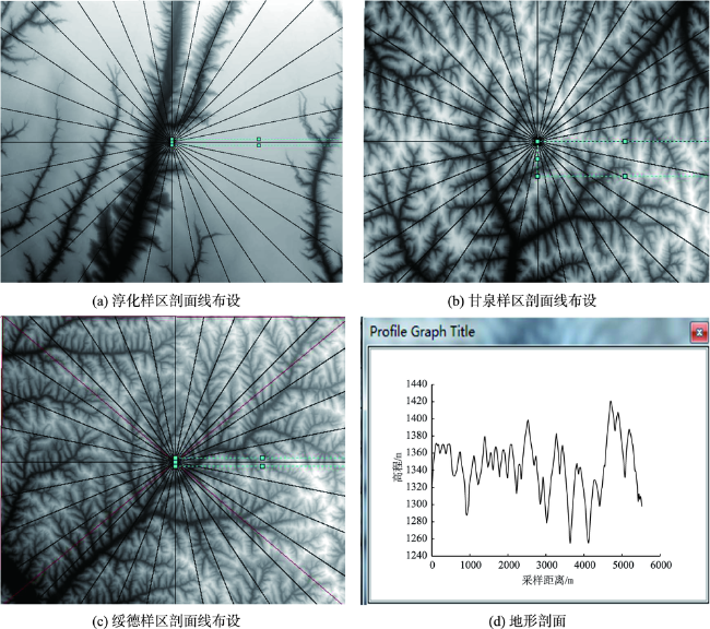
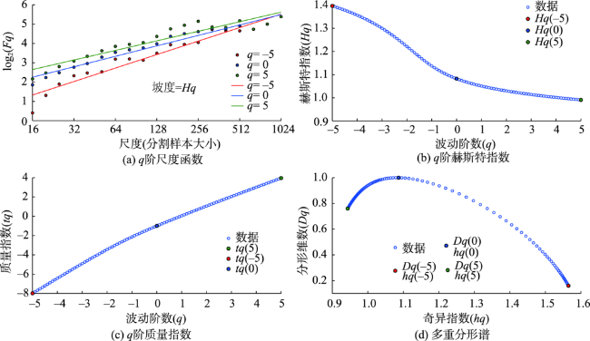
图3 淳化样区正东方向地形各向异性的多重分形分析Fig. 3 Multi-fractal analysis of topographic anisotropy of the east terrain profile in Chunhua site |
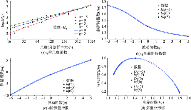
图4 甘泉样区正东方向地形各向异性的多重分形分析Fig. 4 Multi-fractal analysis of topographic anisotropy of the east terrain profile in Ganquan site |
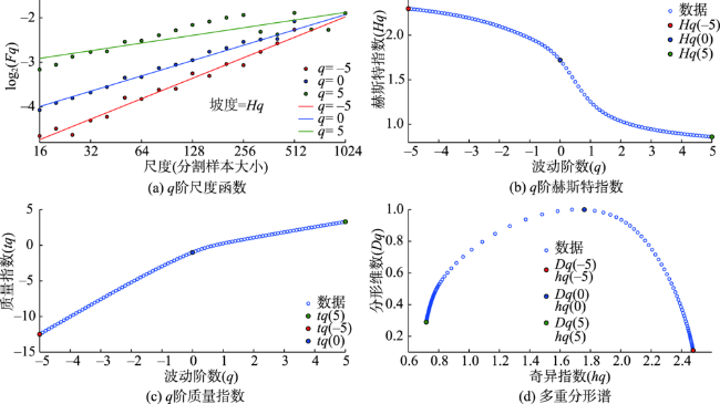
表1 研究样区地形各向异性MF-DFA分析参数Tab. 1 Parameters of topographic anisotropy by multi-fractal analysis of the study sites |
| 研究样区 | 剖面编号 | 波动阶数 | 质量指数 | 奇异指数 | 分形维数 | 赫斯特指数 | 奇异强度 |
|---|---|---|---|---|---|---|---|
| 淳化 | 1(东方向) | -5 | -12.5525 | 2.4748 | 0.1787 | 2.3105 | 1.5594 |
| 0 | -1 | 1.7651 | 1 | 1.8008 | |||
| 5 | 4.1856 | 0.9154 | 0.3913 | 1.0371 | |||
| 9(北方向) | -5 | -12.0216 | 2.3706 | 0.1686 | 2.2043 | 1.3519 | |
| 0 | -1 | 1.5347 | 1 | 1.5633 | |||
| 5 | 4.6423 | 1.0186 | 0.4510 | 1.1285 | |||
| 17(西方向) | -5 | -12.5910 | 2.5003 | 0.0893 | 2.3182 | 1.1683 | |
| 0 | -1 | 1.7889 | 1 | 1.8079 | |||
| 5 | 6.1382 | 1.3320 | 0.5221 | 1.4276 | |||
| 25(南方向) | -5 | -12.9688 | 2.6012 | -0.0370 | 2.3938 | 1.4984 | |
| 0 | -1 | 1.6622 | 1 | 1.6915 | |||
| 5 | 4.9918 | 1.1027 | 0.5219 | 1.1984 | |||
| 甘泉 | 1(东方向) | -5 | -9.6280 | 1.9154 | 0.0511 | 1.7256 | 0.7454 |
| 0 | -1 | 1.2390 | 1 | 1.2431 | |||
| 5 | 4.9730 | 1.1700 | 0.8769 | 1.1946 | |||
| 9(北方向) | -5 | -11.8572 | 2.3967 | -0.1262 | 2.1714 | 1.4216 | |
| 0 | -1 | 1.4349 | 1 | 1.4527 | |||
| 5 | 4.5126 | 0.9706 | 0.3403 | 1.1025 | |||
| 17(西方向) | -5 | -11.1124 | 2.2205 | 0.0098 | 2.0225 | 0.9254 | |
| 0 | -1 | 1.5057 | 1 | 1.5120 | |||
| 5 | 5.8723 | 1.2951 | 0.6034 | 1.3745 | |||
| 25(南方向) | -5 | -10.9682 | 2.1815 | 0.0609 | 1.9936 | 0.8208 | |
| 0 | -1 | 1.6014 | 1 | 1.6091 | |||
| 5 | 6.1585 | 1.3606 | 0.6445 | 1.4317 | |||
| 1(东方向) | -5 | -9.5202 | 1.8849 | 0.0957 | 1.7040 | 0.7132 | |
| 0 | -1 | 1.3744 | 1 | 1.3795 | |||
| 5 | 5.2177 | 1.1717 | 0.6410 | 1.2435 | |||
| 绥德 | 9(北方向) | -5 | -9.5046 | 1.9024 | 0.0076 | 1.7009 | 0.9605 |
| 0 | -1 | 1.2206 | 1 | 1.2294 | |||
| 5 | 4.1827 | 0.9419 | 0.5269 | 1.0365 | |||
| 17(西方向) | -5 | -10.1930 | 2.0422 | -0.0181 | 1.8386 | 1.0032 | |
| 0 | -1 | 1.2235 | 1 | 1.2306 | |||
| 5 | 4.5034 | 1.0391 | 0.6919 | 1.1007 | |||
| 25(南方向) | -5 | -9.9855 | 1.9817 | 0.0769 | 1.7971 | 0.8563 | |
| 0 | -1 | 1.3785 | 1 | 1.3857 | |||
| 5 | 5.0525 | 1.1255 | 0.5747 | 1.2105 |
| [1] |
徐双, 李飞雪, 刘爱利 . 典型黄土地貌高程空间变异性研究[J]. 水土保持研究, 2014,21(5):1-6.
[
|
| [2] |
刘双琳, 李发源, 蒋如乔 , 等. 黄土地貌类型的坡谱自动识别分析[J]. 地球信息科学学报, 2015,17(10):1234-1242.
[
|
| [3] |
薛凯凯, 熊礼阳, 祝士杰 , 等. 基于DEM的黄土崾岘提取及其地形特征分析[J]. 地球信息科学学报, 2018,20(12):1710-1720.
[
|
| [4] |
段家朕, 熊礼阳, 汤国安 . 基岩露头采样密度对黄土古地形重建的影响[J]. 地球信息科学学报, 2016,18(4):461-468.
[
|
| [5] |
汤国安, 李发源, 熊礼阳 . 黄土高原数字地形分析研究进展[J]. 地理与地理信息科学, 2017,33(4):5-11.
[
|
| [6] |
汤国安 . 我国数字高程模型与数字地形分析研究进展[J]. 地理学报, 2014,69(9):1305-1325.
[
|
| [7] |
汤国安, 那嘉明, 程维明 . 我国区域地貌数字地形分析研究进展[J]. 测绘学报, 2017,46(10):372-393.
[
|
| [8] |
|
| [9] |
卢昱铭, 乔雪丽, 吴佳琪 . 地形空间频率层次性及其空间分异性研究——以黄土高原丘陵沟壑区为例[J]. 地下水, 2018,40(1):155-157.
[
|
| [10] |
仝迟鸣, 周成虎, 程维明 . 基于DEM的黄土塬形态特征分析及发育阶段划分[J]. 地理科学进展, 2014,33(1):42-49.
[
|
| [11] |
朱洪芬, 南锋, 徐占军 . 黄土高原盆地土壤有机质与影响因子的空间多尺度关系[J]. 生态学报, 2017,37(24):8348-8360.
[
|
| [12] |
张苏 . 基于遥感纹理的黄土地貌景观图谱研究-以陕北黄土高原为例[D]. 西安:西北大学 2017.
[
|
| [13] |
刘逸文, 熊礼阳, 方炫 . 黄土地貌地形特征点格局研究[J]. 地理与地理信息科学, 2017,33(4):35-41.
[
|
| [14] |
张磊 . 基于核心地形因子分析的黄土地貌形态空间格局研究[D]. 南京:南京师范大学, 2013.
[
|
| [15] |
李阳, 周毅, 雷雪 , 等. 基于流域单元的黄土地貌正负地形因子量化关系模拟[J]. 干旱区资源与环境, 2019,33(7):78-84.
[
|
| [16] |
周毅 . 基于DEM的黄土高原正负地形及空间分异研究[D]. 南京:南京师范大学, 2011.
[
|
| [17] |
|
| [18] |
张佳瑞, 王金满, 祝宇成 . 分形理论在土壤学应用中的研究进展[J]. 土壤通报, 2017,48(1):221-228.
[
|
| [19] |
孙斌, 姚海涛 . 风电场风速时间序列的多重分形去趋势波动分析[J]. 电工技术学报, 2014,29(6):204-210.
[
|
| [20] |
陈晓娜 . 股票收益率序列的多重分形特征分析[J]. 淮北师范大学学报(自然科学版), 2014,2:27-32.
[
|
| [21] |
张翔, 丁勇, 刘小峰 . MF-DFA在癫痫发作期及发作强度检测中的应用[J]. 数据采集与处理, 2013,28(5):664-671.
[
|
| [22] |
张捷, 包浩生 . 分形理论及其在地貌学中的应用-分形地貌学研究综述及展望[J]. 地理研究, 1994,13(3):104-112.
[
|
| [23] |
|
| [24] |
|
| [25] |
|
| [26] |
|
/
| 〈 |
|
〉 |