
基于BEMD分解的地貌分类研究
|
顾文亚(1980— ),女,江苏常州人,副教授,博士生,主要从事3s集成与气象应用。E-mail:wygu@nuist.edu.cn |
收稿日期: 2019-05-30
要求修回日期: 2019-12-06
网络出版日期: 2020-05-18
基金资助
江苏省普通高校研究生科研创新计划项目(KYLX_0850)
国家自然科学基金项目(41805049)
滨江学院校级课题(2019bjyng005)
版权
Geomorphological Classification Research based on BEMD Decomposition
Received date: 2019-05-30
Request revised date: 2019-12-06
Online published: 2020-05-18
Supported by
Research Innovation Program for Postgraduates of Ordinary Universities in Jiangsu Province(KYLX_0850)
National Natural Science Foundation of China(41805049)
The Subject of Binjiang School(2019bjyng005)
Copyright
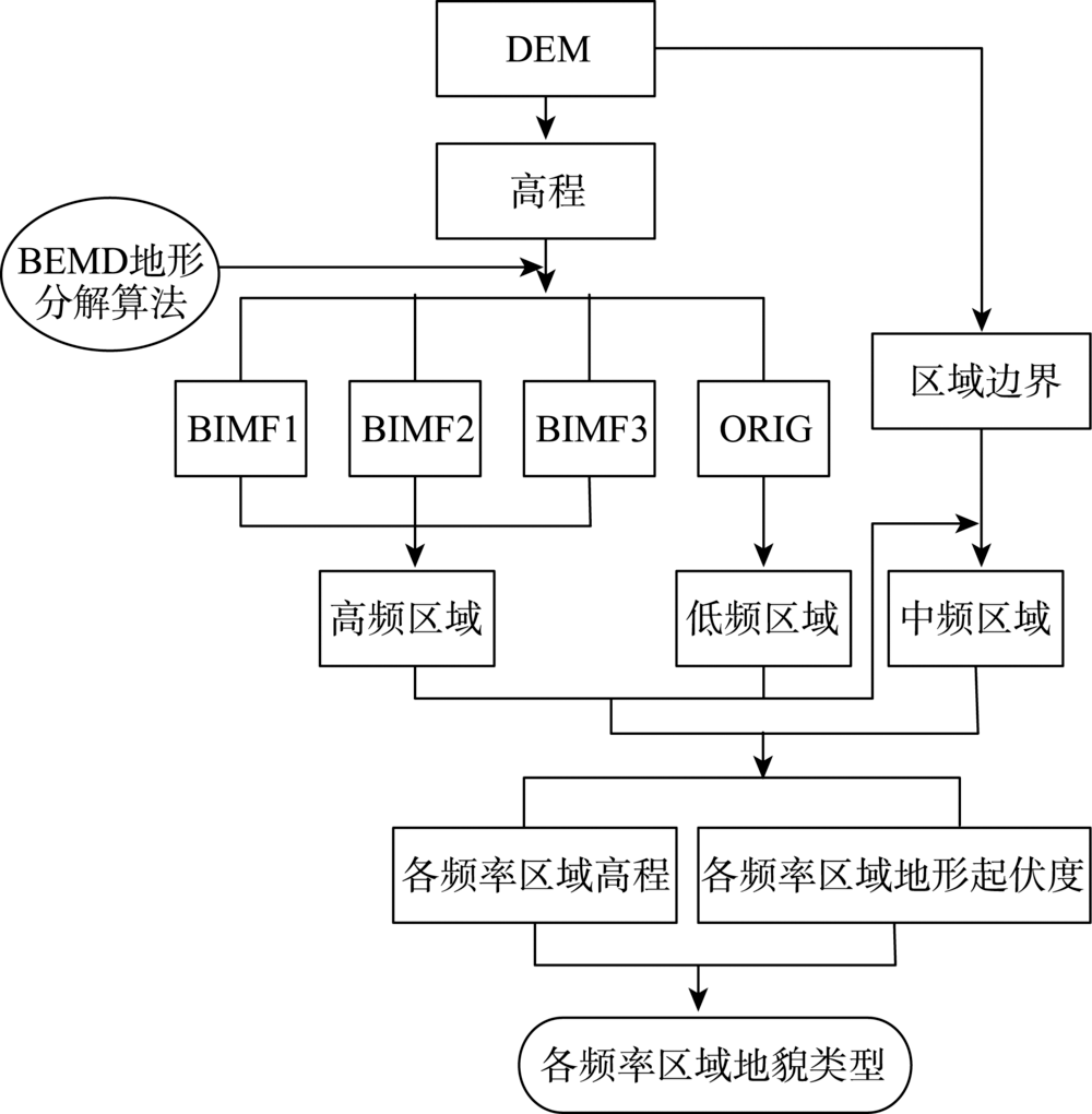
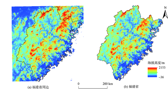
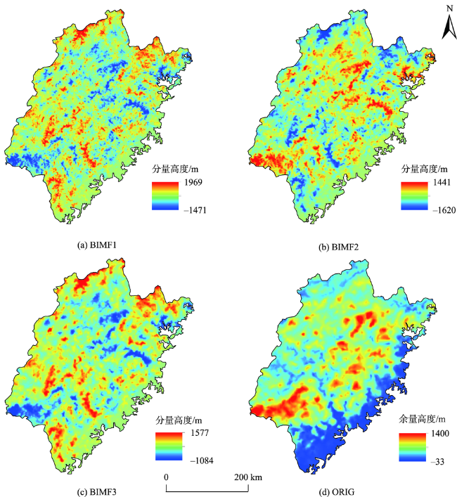
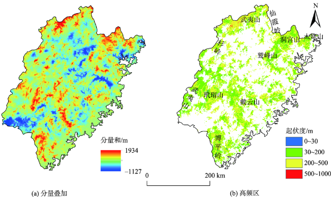
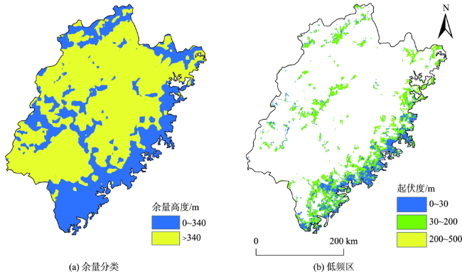
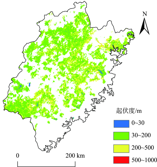
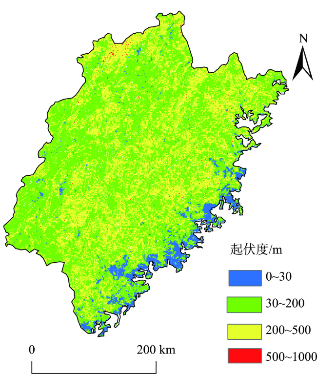
地貌是指地势高低起伏的变化,即地表的形态。地貌划分对气温、降水、太阳辐照等诸多应用领域都有着重要作用。本文选择空间分辨率为90 m的福建省的数字高程模型(DEM)数据作为地理信号,运用二维经验模态分解(BEMD)进行分解处理,得到多个具有不同尺度、不同物理意义的本征模函数(BIMF1—BIMF3)以及对应余量ORIG。这些BIMF分量对应不同尺度的微观地形,ORIG余量表现为该研究区的地貌分布趋势,体现了平原、丘陵与山地的大致分布区域。运用变点分析法确定最佳计算单元,利用地形起伏度对各个信号区域进行一级分类,依据绝对高度进行二级分类,最后将一级分类与二级分类相结合,实现对地形的分类,这一分类过程体现了研究地区地貌组合复杂的特征。结果表明:① 叠加BIMF分量,提取出分量和大于74 m的区域为高频信号区域。该区域以小起伏度的低山为主,并伴随有丘陵和小起伏度中山。② ORIG余量中余量高度小于等于340 m的区域,去除其中包含的高频信号区域后为低频信号区域,该区域以平原、丘陵为主。③ 剩余区域定义为中频信号区域,该区域的地貌以平丘陵和小起伏的山地为主。研究成果表明福建地貌可分为7种主要类型:低频平原,低频丘陵,中频丘陵,高频丘陵,中频小起伏低山,高频小起伏低山,高频小起伏中山。
关键词: 地形分解; 数字高程模型(DEM); 二维经验模式分解(BEMD); 本征模函数(BIMF); 余量函数(ORIG); 地形起伏度; 高频; 低频
顾文亚 , 孟祥瑞 , 朱晓晨 , 邱新法 . 基于BEMD分解的地貌分类研究[J]. 地球信息科学学报, 2020 , 22(3) : 464 -473 . DOI: 10.12082/dqxxkx.2020.190262
Geomorphology refers to the ups and downs of the terrain, that is, the shape of the surface. Geomorph-ological classification plays an important role in many application fields such as temperature, precipitation and solar irradiation. In this paper, the Digital Elevation Model(DEM) data of Fujian province with a spatial resolution of 90 m is selected as the geographic signal. The two-dimensional empirical mode decomposition(BEMD) is applied for decomposition processing to obtain several two-dimensional intrinsic mode functions(BIMF1~ BIMF3) with different scales and different physical meanings as well as the corresponding residual ORIG. These BIMF components correspond to the microtopography of different scales, and ORIG shows the geomorphic distribution trend of the study area, reflecting the general distribution area of plains, hills and mountains. The optimal calculation unit is determined by the method of variable point analysis, and the first order classification of each signal area is carried out by using the degree of relief, and the second level classification is carried out according to the absolute height. Finally, the first class classification and the second order classification are combined to realize the classification of terrain. This classification process reflects the complex characteristics of geomorphological assemblage in the study area. The results show that: (1) Superimpose BIMF components and extract the components and regions larger than 74m as high-frequency signal regions. The region is dominated by the low mountains with small relief amplitude, and is accompanied by middle mountain with small relief amplitude and hills. (2) The region with residual height less than or equal to 340m in ORIG was extracted, and the region containing high frequency signal was removed as the low-frequency signal region, which was mainly plain and hills. (3) The remaining area is defined as the intermediate frequency signal area, and the geomorphology of the area is dominated by flat hills and small mountains with small relief amplitude. The results show that the geomorphology of Fujian can be divided into seven main types: low frequency plain, low frequency hill, intermediate frequency hill, high frequency hill, low mountain with small degree of relief in middle frequency, low mountain with small degree of relief in high frequency, middle mountain with small degree of relief in high frequency.
Key words: topographic decomposition; DEM; BEMD; BIMF; ORIG; degree of relief; high-frequency; low-frequency
表1 地貌分类的海拔高度指标[30]Tab. 1 Altitude indicators for geomorphological classification |
| 地貌类型 | 海拔高度/m |
|---|---|
| 平原 | ≤ 200 |
| 丘陵 | ≤ 500 |
| 低山 | 500~1000 |
| 中山 | 1000~3000 |
| 高山 | 3000~5000 |
| 极高山 | >5000 |
表2 中国第一级地貌类型划分标准[29]Tab. 2 Classification standards of first-level geomorphic types in China |
| 地貌类型 | 地形起伏度/m |
|---|---|
| 平原 | ≤ 30 |
| 丘陵 | 30~200 |
| 小起伏山地 | 200~500 |
| 中起伏山地 | 500~1000 |
| 大起伏山地 | 1000~2500 |
| 极大起伏山地 | >2500 |
表3 宏观分类下的福建省地貌类型Tab. 3 Geomorphic types in Fujian province under macroscopic classification |
| 频率 | 起伏度/m | 高程/m | 地貌类型 |
|---|---|---|---|
| 低频 | ≤ 30 | ≤ 200 | 低频平原 |
| ≤ 200 | ≤ 500 | 低频丘陵 | |
| 中频 | ≤ 200 | ≤ 500 | 中频丘陵 |
| ≤ 500 | ≤ 1000 | 中频小起伏低山 | |
| 高频 | ≤ 200 | ≤ 500 | 高频丘陵 |
| ≤ 500 | ≤ 1000 | 高频小起伏低山 | |
| ≤ 500 | ≤ 2500 | 高频小起伏中山 |
| [1] |
许丽, 李江海, 刘持恒 , 等. 基于数字高程模型(DEM)的可可西里地貌及区划研究[J]. 北京大学学报(自然科学版), 2017,53(5):833-842.
[
|
| [2] |
廖要明, 陈德亮, 高歌 , 等. 中国天气发生器降水模拟参数的气候变化特征[J]. 地理学报, 2009,64(7):871-878.
[
|
| [3] |
王凌梓, 苗俊峰, 韩芙蓉 . 近10年中国地区地形对降水影响研究进展[J]. 气象科技, 2018,46(1):64-75.
[
|
| [4] |
苏时雨, 李钜章 . 地貌制图[M] . 北京: 测绘出版社, 1999.
[
|
| [5] |
Walther Penck. Analysis of geological morphology[M]. Moscow: National Geological Bibliography Press, 1961.
|
| [6] |
斯皮里顿诺夫(苏). 地貌制图学[M]. 北京: 地质出版社, 1956.
[
|
| [7] |
波多别多夫 . 自然地理第二篇地貌学[M]. 北京: 地质出版社, 1958.
[
|
| [8] |
柴宗新 . 按相对高度划分地貌基本形态的建议[M]. 北京: 测绘出版社, 1986.
[
|
| [9] |
中国科学院自然区划工作委员会. 中国地貌区划(初稿)[M]. 北京: 科学出版社, 1959.
[ Working committee of natural zoning, Chinese academy of sciences. Geomorphologic division of China(draft)[M]. Beijing: Science Press, 1959. ]
|
| [10] |
高玄彧 . 地貌基本形态的主客分类法[J]. 山地学报, 2004,22(3):261-266.
[
|
| [11] |
李炳元, 潘保田, 程维明 , 等. 中国地貌区划新论[J]. 地理学报, 2013,68(3):291-306.
[
|
| [12] |
|
| [13] |
|
| [14] |
田丹, 刘爱利, 丁浒 , 等. 地貌形态类型面向对象分类法的改进[J]. 地理与地理信息科学, 2016,32(2):46-51.
[
|
| [15] |
李婧晗, 江岭, 左颖 , 等. 面向对象的安徽省基本地貌类型划分方法. 地理与地理信息科学, 2018,34(5):80-86.
[
|
| [16] |
汪禹芹, 李艳, 刘爱利 . 基于面向对象思想的中国地貌形态类型划分. 遥感信息, 2012,1:13-18.
[
|
| [17] |
仲伟敬, 邢立新, 潘军 , 等. 基于DEM数据的地貌类型快速划分系统研究[J]. 吉林大学学报(信息科学版), 2018,36(5):388-396.
[
|
| [18] |
汤国安 . 我国数字高程模型与数字地形分析研究进展[J]. 地理学报, 2014,69(9):1305-1325.
[
|
| [19] |
孟伟, 李润奎, 段峥 , 等. 基于地貌特征的数字高程模型融合方法[J]. 地球信息科学学报, 2018,20(7):895-905.
[
|
| [20] |
|
| [21] |
|
| [22] |
沈路, 杨富春, 周晓军 , 等. 基于改进EMD与形态滤波的齿轮故障特征提取[J]. 振动与冲击, 2010,29(3):154-157.
[
|
| [23] |
|
| [24] |
宋立新, 高凤娇, 郗朝晖 . 二维EMD分解方法的比较与改进[J]. 电子与信息学报, 2008,30(12):2890-2893.
[
|
| [25] |
宋平舰 . 二维EMD方法及其在图象处理中的应用[D]. 青岛:国家海洋局第一海洋研究所, 2001.
[
|
| [26] |
高凤娇 . 二维EMD方法及其在图像处理中的应用研究[D]. 哈尔滨:哈尔滨理工大学, 2008.
[
|
| [27] |
任德智, 肖前刚, 王勇军 , 等. 基于DEM的成都市基本地貌形态研究[J]. 四川林业科技, 2018,39(2):79-84.
[
|
| [28] |
周廷儒, 施雅风, 陈述彭 . 中国地形区划草案[M]. 北京: 科学出版社, 1956: 21-56.
[
|
| [29] |
|
| [30] |
乔淼 . 地形分解与气象要素局地分布规律分析[D]. 南京:南京信息工程大学, 2017.
[
|
| [31] |
周成虎, 程维明, 钱金凯 , 等. 中国陆地1∶100万数字地貌分类体系研究[J]. 地球信息科学学报, 2009,11(6):707-724.
[
|
| [32] |
程维明, 周成虎, 柴慧霞 , 等. 中国陆地地貌基本形态类型定量提取与分析[J]. 地球信息科学学报, 2009,11(6):725-736.
[
|
/
| 〈 |
|
〉 |
