
神农架林区植被分布与地形的关系研究
|
张兴航(1992— ),女,河北沙河人,博士生,主要从事山地GIS、山地生态环境研究。E-mail:jhj580724@163.com |
收稿日期: 2019-09-27
要求修回日期: 2019-11-14
网络出版日期: 2020-05-18
基金资助
国家科技部基础资源调查专项(2017FY100900)
版权
Study on the Relationship between Terrain and Distribution of the Vegetation in Shennongjia Forestry District
Received date: 2019-09-27
Request revised date: 2019-11-14
Online published: 2020-05-18
Supported by
National Science and Technology Basic Resource Investigation Program(2017FY100900)
Copyright
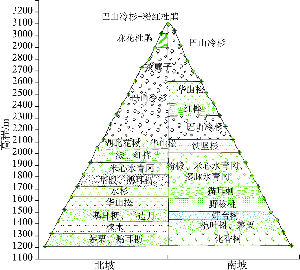
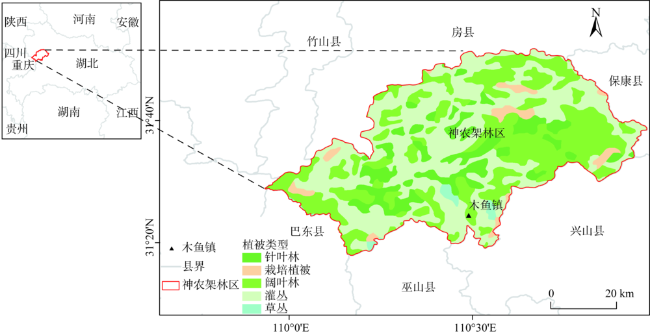
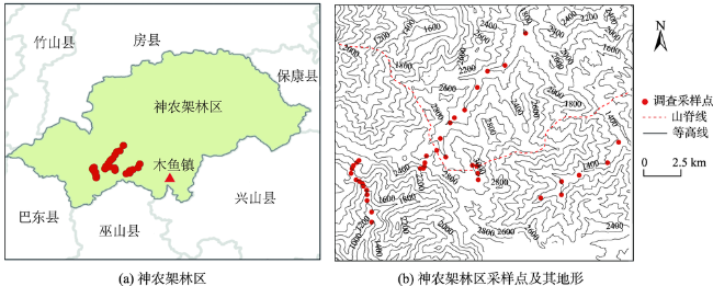
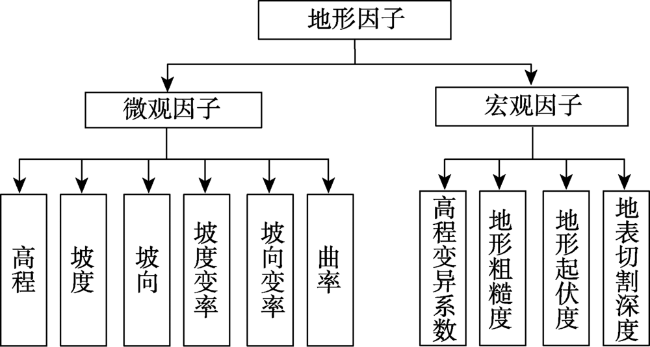
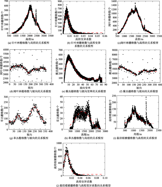
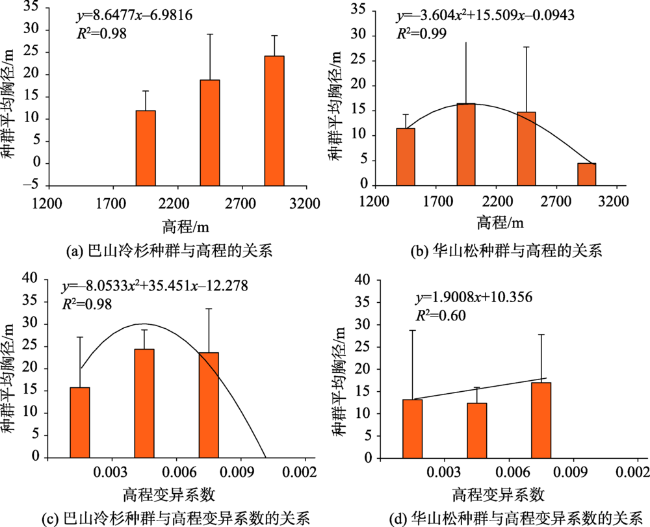
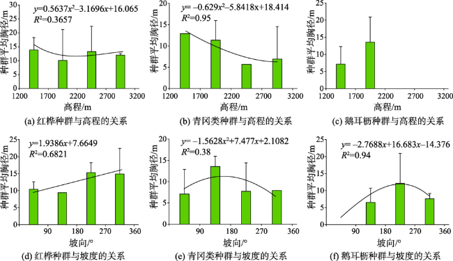
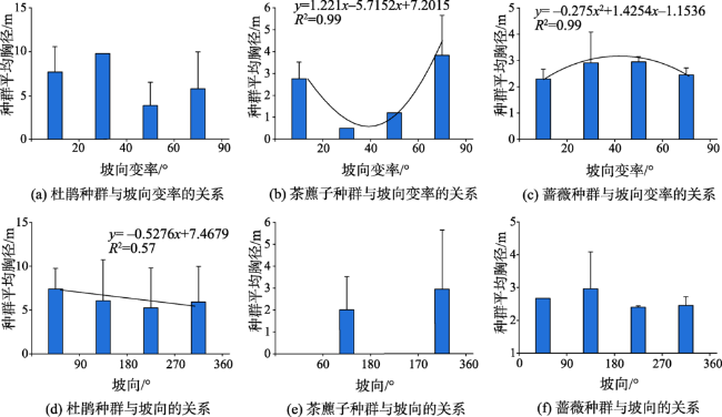
神农架林区是我国物种多样性最为丰富的地区之一,地形地貌复杂,对植被分布影响巨大。本文利用该地区2007年数字高程数据、2007年植被分布图以及2017年野外实地调查数据,基于最大熵模型和空间分析理论,从植被类型和种群两个角度研究该地区不同尺度植被空间分布的地形特征,分别量化植被类型和种群空间分布的地形范围,得到植被类型与地形因子关系模型、植被种群与地形因子关系模型。结果表明:① 神农架林区影响植被空间分布的地形因子不同,其中影响针叶林分布的最重要的地形因子是高程和高程变异系数,影响阔叶林分布的是高程和坡向,影响灌丛分布的是坡向变率和坡向,影响草丛分布的较为分散;② 典型植被种群分布的地形范围和植被类型的基本一致,其中90%针叶林分布在高程1600~2600 m间,典型种群巴山冷杉和华山松主要分布在高程1700~3200 m和1700~2200 m;85%的阔叶林分布在高程1000~2000 m间,典型种群青冈类和鹅耳枥主要分布在高程1200~2200 m间;95%的灌丛分布在坡向变率0~40°间,典型种群杜鹃和蔷薇主要分布在坡向变率小于40°的范围,但相应的关系模型存在差异,植被类型与地形因子为高斯模型,典型种群与地形因子关系模型相对复杂,不同种群的分布模式不同;③ 虽然坡度常作为数字地形的重要因子,但本文研究发现该地区坡度对植被类型和种群分布的影响不明显。研究结果可为神农架林区植被保护和恢复,以及植被规划和管理提供基础参考。
张兴航 , 张百平 , 王晶 , 姚永慧 , 余付勤 . 神农架林区植被分布与地形的关系研究[J]. 地球信息科学学报, 2020 , 22(3) : 482 -493 . DOI: 10.12082/dqxxkx.2020.190553
The Shennongjia Forestry District is one of the areas with the highest biodiversity in China. The complex topography exerts great influence on vegetation distribution in this region. This paper used the maximum entropy model (MaxEnt), digital elevation data, vegetation distribution map, and field-surveyed data, to study how the topographic characteristics affect local typical vegetation distributions at two scales, i.e., vegetation type and population levels. The relationship models between vegetation type and topographic factors, and between plant population and topographic factors were established respectively by quantifying the topographic ranges of vegetation types and plant species. Results show that: (1) the spatial distribution of different vegetation types was affected by different topographic factors. The distribution of coniferous forests was affected by elevation and coefficient of variation in elevation, the distribution of broad-leaved forests was controlled by elevation and aspect, and the distribution of shrubs was controlled by aspect and the slope of aspect. The factors affecting the distribution of grasses were various. (2) The elevation ranges of typical plant species were generally consistent with those of vegetation types. Specifically, 90% of coniferous forests were distributed at elevation between 1600 and 2600 m, and the typical populations of Abies fargesii and Pinus armandii were distributed at elevation of 1700~3200 m. 85% of the broad-leaved forests were distributed within the range of 1000 m to 2000 m in elevation, and the typical populations of Cyclobalanopsis glauca, Carpinus turczaninowii concentrated at elevation between1000 to 2000 m. 95% of shrubs occurred at slope of aspect within 0~40 degrees, and the typical populations of Rhododendron simsii and Rosaceae mainly occurred at slope of aspect less than 40 degrees. The relationship models used for vegetation types and plant species were different. The relationship between vegetation types and topographic factors was fitted using Gauss model. While the relationship between typical species and topographic factors was relatively complex, and the distribution patterns of different species were even different. (3) Vegetation distribution showed a rather weak relationship with typical slope characteristic. This study provides a basic reference for vegetation protection, vegetation restoration, and vegetation management in the Shennongjia region.
表1 神农架林区植被类型与地形因子关系模型的拟合参数Tab. 1 Fitting parameters of relationship model between vegetation types and topographic factors in Shennongjia Forestry District |
| 关系模型 | 拟合参数 | ||||
|---|---|---|---|---|---|
| a | b | c | w | /% | |
| 针叶林与高程 | 464.5 | 2005.7 | 25.3 | 356.2 | 94.2 |
| 针叶林与高程变异系数 | 537.3 | 0.0056 | 32.4 | 0.003 | 92.8 |
| 阔叶林与高程 | 1189.9 | 1646.0 | -14.3 | 457.6 | 97.9 |
| 阔叶林与坡向(第一个峰) | 3 054 761.1 | 76.0 | -3 050 725.7 | 4171.6 | 33.2 |
| 阔叶林与坡向(第二个峰) | 989 602.2 | 304.5 | -985 918.5 | 3557.6 | 22.1 |
| 灌丛与坡向变率 | 423.9 | 13.1 | 77.5 | 9.5 | 63.1 |
| 灌丛与坡向(第一个峰) | 2301.6 | 14.8 | 2980.4 | 100.5 | 62.6 |
| 灌丛与坡向(第二个峰) | — | — | — | — | — |
| 草丛与坡向(第一个峰) | 59.8 | 88.7 | 71.3 | 17.6 | 66.9 |
| 草丛与坡向(第二个峰) | 148.5 | 246.9 | 58.4 | 40.2 | 89.1 |
| 草丛与高程 | 34.4 | 1361.3 | -1.6 | 545.7 | 65.2 |
| 栽培植被与高程 | 89.3 | 1085.8 | 37.6 | 244.4 | 62.4 |
| 栽培植被与高程变异系数 | 672.0 | 0.0093 | 45.7 | 0.006 | 93.8 |
图7 神农架调查样地针叶林典型植被种群与高程和高程变异系数的关系Fig. 7 Relationship between typical vegetation population and altitude and altitude variability coefficient of coniferous forest in Shennongjia |
图8 神农架调查样地阔叶林典型植被种群与高程和坡向的关系Fig. 8 Relationship between typical vegetation populations and elevation and slope direction of broad-leaved forest in Shennongjia |
| [1] |
伍光和, 蔡运龙 . 综合自然地理学.第2版[M]. 北京: 高等教育出版社, 2004.
[
|
| [2] |
黄秉维 . 现代自然地理[M]. 北京: 科学出版社, 2004.
[
|
| [3] |
程东亚, 李旭东 . 喀斯特地区植被覆盖度变化及地形与人口效应研究[J]. 地球信息科学学报, 2019,21(8):1227-1239.
[
|
| [4] |
汤国安, 李发源, 刘学军 . 数字高程模型教程[M]. 北京: 科学出版社, 2010.
[
|
| [5] |
|
| [6] |
薛凯凯, 熊礼阳, 祝士杰 , 等. 基于DEM的黄土崾岘提取及其地形特征分析[J]. 地球信息科学学报, 2018,20(12):1710-1720.
[
|
| [7] |
宋朝枢 . 神农架自然保护区科学考察集[M]. 北京: 中国林业出版社, 1999.
[
|
| [8] |
沈茂才 . 中国秦岭生物多样性的研究和保护[M]. 北京: 科学出版社, 2010.
[
|
| [9] |
廖明尧 . 神农架地区自然资源综合调查报告[M]. 北京: 中国林业出版社, 2015.
[
|
| [10] |
马旭东, 张苏峻, 苏志尧 , 等. 车八岭山地常绿阔叶林群落结构特征与微地形条件的关系[J]. 生态学报, 2010,30(19):5151-5160.
[
|
| [11] |
张容, 董廷发, 邓晓保 , 等. 西双版纳20公顷样地热带森林植被数量分类与排序[J]. 生态学杂志, 2018,37(2):347-352.
[
|
| [12] |
张梅玲, 徐睿择 . 定南县岭北矿区植被覆盖与地形因子关系分析[J]. 地理信息世界, 2018,25(4):50-55.
[
|
| [13] |
赵鹏, 屈建军, 徐先英 , 等. 长江源区沙化高寒草地植被群落特征及其与地形因子的关系[J]. 生态学报, 2019,39(3):1030-1040.
[
|
| [14] |
李亚飞, 刘高焕 . 大香格里拉地区植被空间分布的环境特征[J]. 自然资源学报, 2011,26(8):1353-1363.
[
|
| [15] |
|
| [16] |
|
| [17] |
|
| [18] |
|
| [19] |
|
| [20] |
张金屯 . 数量生态学[M]. 北京: 科学出版社, 2004.
[
|
| [21] |
|
| [22] |
|
| [23] |
张东方, 张琴, 郭杰 , 等. 基于MaxEnt模型的当归全球生态适宜区和生态特征研究[J]. 生态学报, 2017,37(15):5111-5120.
[
|
| [24] |
|
| [25] |
|
| [26] |
|
| [27] |
|
| [28] |
丁军军 . 神农架森林土壤微生物沿海拔分布格局及形成机制[D]. 北京:清华大学, 2016.
[
|
| [29] |
中国科学院《中国植被图》编辑委员会. 中华人民共和国植被图(1:100万)[M]. 北京: 地质出版社, 2007.
[ Editorial committee of vegetation map of China, CAS. Vegetation map of the People's Republic of China (1:1 000 000) [M]. Beijing: Geological Publishing House, 2007. ]
|
| [30] |
刘爱利 . 基于1:100万DEM的我国地形地貌特征研究[D]. 西安:西北大学, 2004.
[
|
| [31] |
井学辉, 曹磊, 郭仲军 , 等. 阿尔泰山小东沟林区植被随地形分布规律[J]. 应用与环境生物学报, 2015,21(3):152-158.
[
|
| [32] |
|
| [33] |
|
| [34] |
杨帆 . 基于DEM形态分析的湖南丘陵地形景观策略研究[D]. 长沙:湖南大学, 2015.
[
|
| [35] |
|
| [36] |
|
| [37] |
王毅, 郭跃 . 喀斯特地貌区植被覆盖与地形因子的空间关系分析——以贵州普定县为例[J]. 长江流域资源与环境, 2018,27(1):157-167.
[
|
| [38] |
胡俊忠, 张镱锂, 于海彬 . 基于MaxEnt模型和GIS的青藏高原紫花针茅分布格局模拟[J]. 应用生态学报, 2015,26(2):505-511.
[
|
/
| 〈 |
|
〉 |

