
Jason-2测高卫星对湖泊水位的监测精度评价
|
何 飞(1994— ),男,安徽安庆人,硕士生,主要从事水土资源综合评价研究。E-mail: hef.17s@igsnrr.ac.an |
收稿日期: 2019-11-04
要求修回日期: 2019-02-13
网络出版日期: 2020-05-18
基金资助
中国科学院战略性先导科技专项(XDA23090302)
国家自然科学基金项目(41571027)
版权
Evaluation of the Monitoring Accuracy of Lake Water Level by the Jason-2 Altimeter Satellite
Received date: 2019-11-04
Request revised date: 2019-02-13
Online published: 2020-05-18
Supported by
Special project of strategic leading science and technology of Chinese Academy of Sciences(XDA23090302)
National Natural Science Foundation of China(41571027)
Copyright
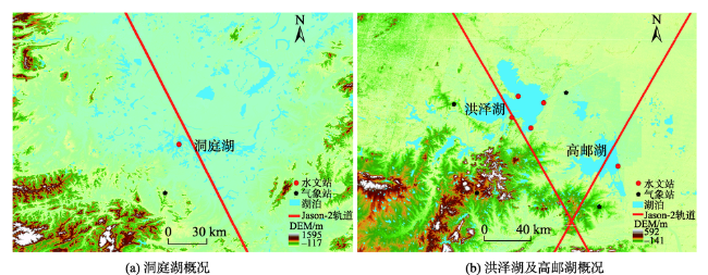
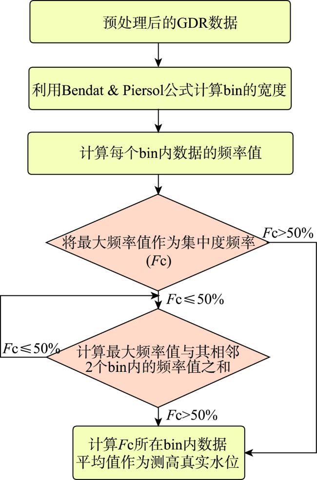
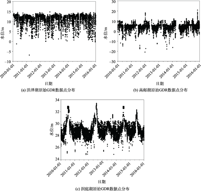
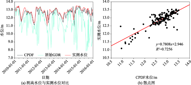
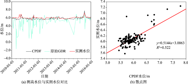
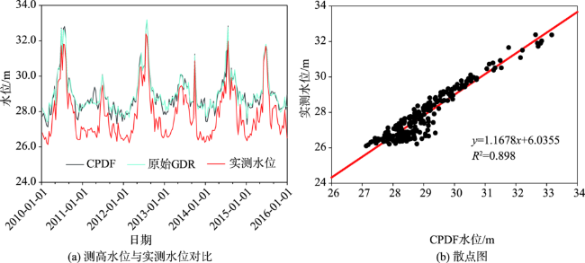
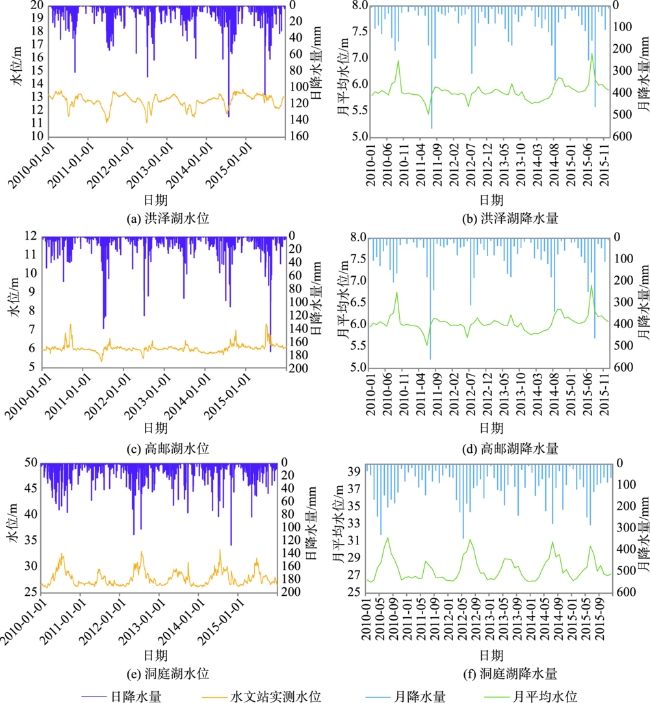
湖泊水位是评估湖泊水量变化的重要指标。本文以洪泽湖、高邮湖及洞庭湖为研究对象,利用集中度的概率密度函数方法(CPDF)来提高Jason-2测高数据精度,分析了降水量与各个湖泊水位变化的相关性,并基于实测水位数据对比评价了Jason-2测高卫星原始GDR数据和CPDF方法处理后的卫星数据的精度。结果表明:① Jason-2原始GDR数据点的分布存在疏密之分,大部分数据分布相对集中,且有一定的周期变化,但评价结果显示精度较差,故原始GDR数据不能直接用于湖泊水位监测;② CPDF方法可以极大提高测高卫星的水位数据精度,洪泽湖与高邮湖的均方根误差分别由1.92 m与1.74 m减少到了0.32 m和0.36 m,相关系数由0.28和0.04提高到了0.85和0.72。对于南北宽度较窄且日水位变化较大的湖泊(如洞庭湖),CPDF方法提高原始GDR结果的精度有限;③ 洞庭湖降水与水位相关性最强,高邮湖次之,而洪泽湖降水与水位成不显著的负相关,是洪泽湖水利工程对于水位的调节导致了这一结果。本研究对于利用测高卫星获得湖泊水位值,进而对湖泊进行动态监控,特别是在填补资料匮乏地区湖泊水位数据方面具有重要意义。

何飞 , 刘兆飞 , 姚治君 . Jason-2测高卫星对湖泊水位的监测精度评价[J]. 地球信息科学学报, 2020 , 22(3) : 494 -504 . DOI: 10.12082/dqxxkx.2020.190651
As one of the important characteristics of lakes, lake water level is an important indicator for evaluating the change of lake water storage capacity. As a new remote sensing monitoring technology, satellite altimetry technology has played an increasingly important role in monitoring the dynamic changes of lake waters, and has become an effective means for lake research, water resources investigation and wetland protection. This study took Hongze Lake, Gaoyou Lake and Dongting Lake as examples, using the Centralized Probability Density Function method (CPDF) to improve the accuracy of Jason-2 altimetry data, as well as analyze the correlation of precipitation and water level of each lake. Besides, based on the measured water level data we compared the accuracy of the original GDR data of the Jason-2 altimeter satellite and the satellite data processed by the CPDF method. Results show that: (1) The distribution of Jason-2 original GDR data points is sparse, most of the data are relatively concentrated, and there are certain periodic changes, but the evaluation results show poor accuracy, so the original GDR data cannot be directly used for lake water level monitoring. (2) CPDF method can greatly improve the accuracy of the water level data of the altimeter satellite. The evaluation results of Hongze Lake and Gaoyou Lake show that the RMSE decreased from 1.92m and 1.74m to 0.32 m and 0.36m, and the correlation coefficient increased from 0.28 and 0.04 to 0.85 and 0.72, indicating that Jason-2 altimetry data processed by the CPDF method can achieve higher accuracy in lake water level monitoring. However, it is worth noting that for the lake, which is with narrow north-south widths and large changes in daily water levels (such as Dongting Lake), the accuracy of the raw GDR improved by the CPDF method would be limited. (3) The precipitation of Dongting Lake had the strongest correlation with the water level, followed by Gaoyou Lake,the water level changes of Gaoyou Lake and Dongting Lake lag behind the precipitation by about 1 month and 1-2 months respectively. However, the precipitation of Hongze Lake was not significantly negatively correlated with the water level, which is partly due to the adjustment of water level by the Hongze Lake water conservancy project. This study is of great significance for obtaining lake water level values using altimetry satellites, and then for dynamic monitoring of lakes, especially in filling lake water level data in data-poor areas.
表2 基于集中度的概率密度函数法(CPDF)处理结果精度评价Tab. 2 Accuracy evaluation table of centralized probability density function method(CPDF)result |
| 湖泊名称 | 洪泽湖 | 高邮湖 | 洞庭湖 | |
|---|---|---|---|---|
| 原始GDR平均值/m | 11.39 | 5.58 | 29.01 | |
| 原始GDR标准差/m | 2.47 | 2.62 | 1.23 | |
| 实测数据平均值/m | 12.80 | 6.09 | 26.80 | |
| 实测数据标准差/m | 0.47 | 0.25 | 1.42 | |
| CPDF平均值/m | 12.70 | 5.95 | 28.99 | |
| CPDF标准差/m | 0.52 | 0.34 | 1.15 | |
| 均值差/m | CPDF | 0.38 | 0.25 | 0.85 |
| 原始GDR | 1.15 | 1.04 | 0.79 | |
| 均方根误差/m | CPDF | 0.32 | 0.36 | 1.27 |
| 原始GDR | 1.92 | 1.74 | 1.3 | |
| 相关系数 | CPDF | 0.85 | 0.72 | 0.95 |
| 原始GDR | 0.28 | 0.04 | 0.96 | |
| 湖泊面积/km2 | 879.10 | 612.30 | 153.00 | |
表3 月平均水位与月降水量相关关系Tab. 3 The correlation between monthly average water level and monthly precipitation |
| 洪泽湖 | 高邮湖 | 洞庭湖 | ||||||
|---|---|---|---|---|---|---|---|---|
| 滞后月数 | 相关系数 | 显著性* | 相关系数 | 显著性* | 相关系数 | 显著性* | ||
| 0 | -0.31 | 显著 | 0.24 | 显著 | 0.56 | 显著 | ||
| 1 | 0.08 | 不显著 | 0.43 | 显著 | 0.64 | 显著 | ||
| 2 | 0.22 | 不显著 | 0.18 | 显著 | 0.64 | 显著 | ||
| 3 | 0.16 | 不显著 | 0.16 | 不显著 | 0.33 | 显著 | ||
注:*表示显著性水平为0.01。 |
| [1] |
杨桂山, 马荣华, 张路 , 等. 中国湖泊现状及面临的重大问题与保护策略[J]. 湖泊科学, 2010,22(6):799-810.
[
|
| [2] |
赵云, 廖静娟, 沈国状 , 等. 卫星测高数据监测青海湖水位变化[J]. 遥感学报, 2017,21(4):633-644.
[
|
| [3] |
金晓媚, 高萌萌, 柯珂 , 等. 巴丹吉林沙漠湖泊遥感信息提取及动态变化趋势[J]. 科技导报, 2014,32(8):15-21.
[
|
| [4] |
杨珂含, 姚方方, 董迪 , 等. 青藏高原湖泊面积动态监测[J]. 地球信息科学学报, 2017,19(7):972-982.
[
|
| [5] |
郝贵斌, 吴波, 张立福 , 等. ESTARFM模型在西藏色林错湖面积时空变化中的应用分析(1976-2014年)[J]. 地球信息科学学报, 2016,18(6):833-846.
[
|
| [6] |
李均力, 陈曦, 包安明 . 2003-2009年中亚地区湖泊水位变化的时空特征[J]. 地理学报, 2011,66(9):1219-1229.
[
|
| [7] |
|
| [8] |
蔡宇, 柯长青 . 基于Jason-2测高数据的新西兰陶波湖水位变化监测[J]. 水电能源科学, 2017,35(8):31-34.
[
|
| [9] |
|
| [10] |
|
| [11] |
|
| [12] |
|
| [13] |
张鑫, 吴艳红, 张鑫 . 基于多源卫星测高数据的扎日南木错水位动态变化(1992-2012年)[J]. 自然资源学报, 2015,30(7):1153-1162.
[
|
| [14] |
姜卫平, 褚永海, 李建成 , 等. 利用ENVISAT测高数据监测青海湖水位变化[J]. 武汉大学学报·信息科学版, 2008,33(1):64-67.
[
|
| [15] |
褚永海, 李建成, 姜卫平 , 等. 利用Jason-1数据监测呼伦湖水位变化[J]. 大地测量与地球动力学, 2005,25(4):11-16.
[
|
| [16] |
|
| [17] |
李程, 章传银, 柯宝贵 , 等. 利用卫星测高数据监测巢湖水位变化[J]. 测绘科学, 2015,40(12):12-15.
[
|
| [18] |
王红, 孙福宝, 杨涛 , 等. Jason_2卫星测高数据在长江中游水位监测中的应用[J]. 三峡生态环境监测, 2018,3(3):48-54.
[
|
| [19] |
李景刚, 李纪人, 阮宏勋 , 等. Jason-2卫星测高数据在陆地水域水位变化监测中的应用——以南洞庭湖为例[J]. 自然资源学报, 2010,25(3):502-510.
[
|
| [20] |
高永刚, 郭金运, 岳建平 . 卫星测高在陆地湖泊水位变化监测中的应用[J]. 测绘科学, 2008,33(6):73-75,29.
[
|
| [21] |
|
| [22] |
范亚民 . 淮河中下游洪泽湖水域动态变化研究[J]. 长江流域资源与环境, 2010,19(12):1397-1403.
[
|
| [23] |
叶正伟 . 淮河洪泽湖洪涝灾害特征与成灾本底机理分析[J]. 水土保持研究, 2006(4):90-92,273.
[
|
| [24] |
夏双, 阮仁宗, 颜梅春 , 等. 洪泽湖区土地利用/覆盖变化分析[J]. 遥感信息, 2013,28(1):54-59,64.
[
|
| [25] |
陈玥, 管仪庆, 苗建中 , 等. 基于长期水文变化的苏北高邮湖生态水位及保障程度[J]. 湖泊科学, 2017,29(2):398-408.
[
|
| [26] |
李建成, 褚永海, 姜卫平 , 等. 利用卫星测高资料监测长江中下游湖泊水位变化[J]. 武汉大学学报·信息科学版, 2007,32(2):144-147.
[
|
| [27] |
中华人民共和国水利部水文局. 中华人民共和国水文年鉴:长江流域水文资料[M]. 北京:中华人民共和国水利部水文局, 2010-2015.
[ Bureau of Hydrology, Ministry of Water Resources, P. R. China. Hydrological data of Yangtze river basin in Annual Hydrological Report P.R. China[M]. Beijing: Bureau of Hydrology, Ministry of Water Resources, 2010- 2015. ]
|
| [28] |
中华人民共和国水利部水文局. 中华人民共和国水文年鉴:淮河流域水文资料[M]. 北京:中华人民共和国水利部水文局, 2010-2015.
[ Bureau of Hydrology, Ministry of Water Resources, P. R. China. Hydrological data of Huaihe river basin in Annual Hydrological Report P.R. China[M]. Beijing: Bureau of Hydrology, Ministry of Water Resources, 2010- 2015. ]
|
| [29] |
|
| [30] |
|
| [31] |
|
| [32] |
|
| [33] |
|
| [34] |
梁子亮, 岳建平 . 利用卫星测高监测高邮湖水位变化[J]. 测绘通报, 2013(11):65-67,125.
[
|
/
| 〈 |
|
〉 |