
多因素约束的城市空间扩张元胞自动机构建及其应用研究
|
胡 最(1977— ),男,湖南宁乡人,博士,教授,从事GIS原理与技术应用、数字地形分析、地图符号、地理模拟和文化景观基因研究。E-mail:fuyanghuzui@163.com |
收稿日期: 2019-05-17
要求修回日期: 2019-10-14
网络出版日期: 2020-05-18
基金资助
国家自然科学基金项目(41771188)
衡阳师范学院基金项目(16D14)
湖南省社科评审委课题(XSP17YBZC008)
湖南省人居环境基地项目(RJ18k04)
版权
MCES-CA based Urban Expansion Simulation of Hengyang City
Received date: 2019-05-17
Request revised date: 2019-10-14
Online published: 2020-05-18
Supported by
National Science Foundation of China(41771188)
Foundation of Hengyang Normal University(16D14)
Foundation of Social Science Council of Hunan Province(XSP17YBZC008)
Opening Foundation of Hunan Human Inhabitation Base(RJ18k04)
Copyright
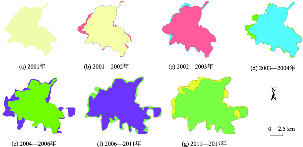
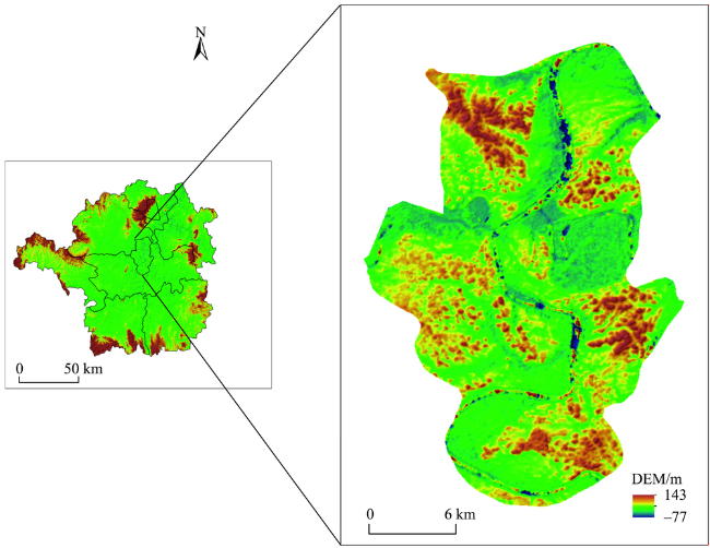
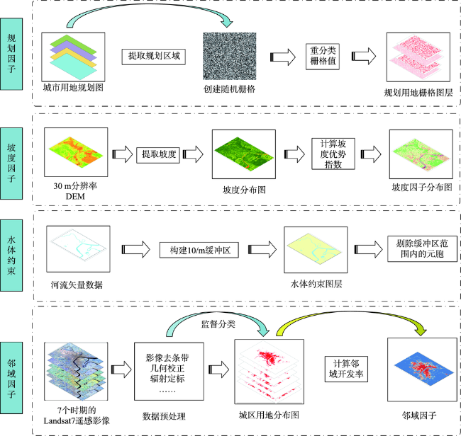
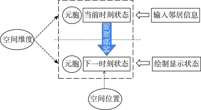
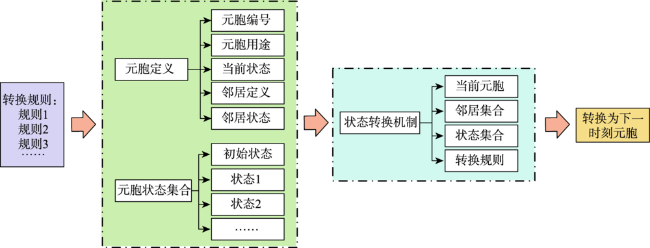
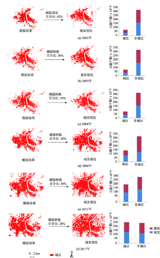
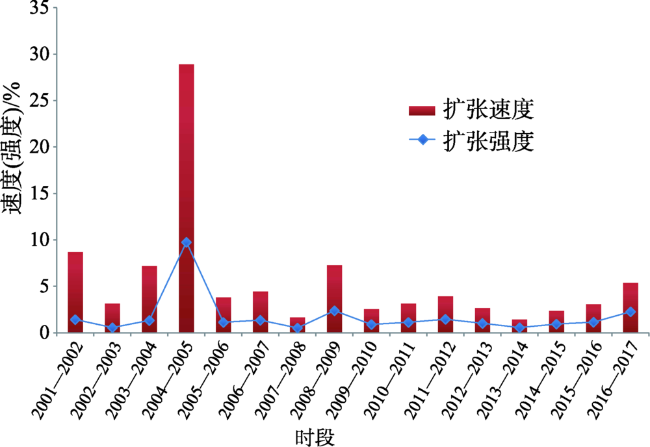
城市空间扩张是复杂的社会经济进程,伴随着人口、政策和城市要素向外推进等现象,是评判城市化水平的重要指标。元胞自动机(Cellular Automata, CA)是可以模拟事物发展演化过程的系统动力学模型,可以有效揭示城市空间扩张过程的特征和机制,具有广阔的应用前景。根据Geo-CA的内涵与特征,以湖南省衡阳市为例,考虑城市空间扩张的主要影响因素,本文提出了多因素制约的城市空间扩张过程元胞自动机模拟模型(Multi-factors Constrained Expanding Simulation CA, MCES-CA)。结合多期LANDSET影像、DEM和规划数据等数据源,论文构建并实现了MCES-CA模型,取得了较好的模拟结果。经检验,MCES-CA的模拟精度总体达89.24%。模拟结果显示衡阳主城区的空间扩张具有多方向、多阶段的特征,受到城市的自然环境和发展规划等因素的制约。本文研究表明,MCES-CA是一种简洁、易实现且高效的城市空间扩张模拟工具,今后应该结合人工智能方法提高模拟结果的精度。
胡最 , 王慧 . 多因素约束的城市空间扩张元胞自动机构建及其应用研究[J]. 地球信息科学学报, 2020 , 22(3) : 616 -627 . DOI: 10.12082/dqxxkx.2020.190240
Urban Expansion (UE) is a critical parameter to examine urbanization level. In fact, UE is often accompanied with people, strategies, and urban elements extending over the old edge of city. Hence, UE is a highly complex socioeconomic phenomenon. Dynamic models are very effective to reveal the features and mechanisms of UE. In particular, Cellular Automata (CA) is one of the kinetic models to simulate the natural evolution process and famous for its broad range of applications. A large amount of research findings argue that CA is one of the most potential tools to understand UE. In this study, a multi-factor restricted expansion simulation model of CA (MCES-CA) was proposed according to CA's main features and the main influencing elements of UE. This paper took a middle-zone city named Hengyang City as the case study area. Hengyang City is located in southern Hunan Province of China, and has been positioning to develop into the regional central city of southern Hunan. Hence, it is high significant to reveal the main features and mechanisms of Hengyang City's expansion based on MCES-CA. Firstly, we downloaded LANDSAT images and ASTER DEMs through the internet, and collected Hengyang City's Planning datasets from the Planning Burau of Hengyang Government. Next, we developed the MCES-CA model by the Model Builder Tools of ArcGIS. Then, we ran it to observe the entire expansion process of Hengyang City from 2001 to 2017. We employed the Expanding Intensity Index (EII) and Expanding Velocity Index (EVI) to assess the MCES-CA model. Results show: (1) Hengyang City presented different expansion directions in different ages. (2) The spatial expansion process of Hengyang City was composed of two main stages. (3) The main factors of shaping the expansion process of Hengyang City were geo-environments and development planning. (4) The simulation results were in accordance with the real states of Hengyang's UE. Our findings suggest that MCES-CA is a potentially popular tool to capture the EU processes of cities because it is easy to build and complete. For future research, we can improve the simulation accuracy of MCES-CA by refining transformation rules.
表1 MCES-CA的ADT描述Tab. 1 ADT descriptions for MCES-CA |
| 类名 | 元胞 | 邻居 | 状态 | 转换规则 |
|---|---|---|---|---|
| 数据成员 | 空间坐标 | 空间坐标 | 工业 | 周围有铁路、港口、仓储等用地时转换成工业用地 |
| ID标识号 | ID标识号 | 仓储 | 周围有铁路、港口、工业等用地时转换成仓储用地 | |
| 当前状态值 | 当前状态值 | 铁路 | 通过规划设定 | |
| 邻居集合 | 当前用地类型 | 道路 | 通过规划设定 | |
| 当前用地类型 | 港口 | 通过规划设定 | ||
| 是否转换 | 居住 | 周围有工业、道路等用地时转换成居住用地 | ||
| 设施 | 通过规划设定 |
表2 城市主要建设用地适宜规划坡度Tab. 2 Appropriate slopes for different urban uses |
| 用地名称 | 最小坡度/% | 最大坡度/% |
|---|---|---|
| 工业用地 | 0.2 | 10 |
| 仓储用地 | 0.2 | 10 |
| 铁路用地 | 0 | 2 |
| 城市道路用地 | 0.2 | 8 |
| 港口用地 | 0.2 | 5 |
| 居住用地 | 0.2 | 25 |
| 公共设施用地 | 0.2 | 20 |
| 其他 | - | - |
表3 衡阳市中心城区用地的坡度优势指数Tab. 3 Slope Advantage Index for main urban area of Hengyang City |
| 用地类型 | 0~2° | 2~5° | 5~15° | 15~25° | 25~64° |
|---|---|---|---|---|---|
| 城区 | 1.56 | 0.18 | 2.49 | 1.36 | 0.33 |
| 非城区 | 0.6 | 1.53 | 0.04 | 0.81 | 1.99 |
表4 2001—2017年衡阳市主城区建成区面积Tab. 4 Urban areas of Downtown Hengyang from 2001 to 2017 |
| 年份 | 面积/km2 | 年份 | 面积/km2 |
|---|---|---|---|
| 2001 | 29.85 | 2010 | 64.76 |
| 2002 | 32.44 | 2011 | 66.80 |
| 2003 | 33.46 | 2012 | 69.42 |
| 2004 | 35.87 | 2013 | 71.27 |
| 2005 | 53.41 | 2014 | 72.28 |
| 2006 | 55.45 | 2015 | 73.98 |
| 2007 | 57.91 | 2016 | 76.05 |
| 2008 | 58.86 | 2017 | 80.13 |
| 2009 | 63.15 |
| [1] |
方创琳, 王振波, 马海涛 . 中国城市群形成发育规律的理论认知与地理学贡献[J]. 地理学报, 2018,73(4):651-665.
[
|
| [2] |
任宇飞, 方创琳, 蔺雪芹 . 中国东部沿海地区四大城市群生态效率评价[J]. 地理学报, 2017,72(11):2047-2063.
[
|
| [3] |
张引, 杨庆媛, 闵婕 . 重庆市新型城镇化质量与生态环境承载力耦合分析[J]. 地理学报, 2016,71(5):817-828.
[
|
| [4] |
鲍超 . 中国城镇化与经济增长及用水变化的时空耦合关系[J]. 地理学报, 2014,69(12):1799-1809.
[
|
| [5] |
刘涛, 齐元静, 曹广忠 . 中国流动人口空间格局演变机制及城镇化效应—基于2000和2010年人口普查分县数据的分析[J]. 地理学报, 2015,70(4):567-581.
[
|
| [6] |
高金龙, 包菁薇, 刘彦随 , 等. 中国县域土地城镇化的区域差异及其影响因素[J]. 地理学报, 2018,73(12):2329-2344.
[
|
| [7] |
陈妤凡, 王开泳 .撤县 (市)设区对城市空间扩展的影响机理-以杭州市为例[J]. 地理研究, 2019,38(2):221-234.
[
|
| [8] |
崔学刚, 方创琳, 李君 , 等. 城镇化与生态环境耦合动态模拟模型研究进展[J]. 地理科学进展, 2019,38(1):111-125.
[
|
| [9] |
|
| [10] |
|
| [11] |
|
| [12] |
|
| [13] |
刘沛林 . 诗意栖居: 中国传统人居思想及其现代启示[J]. 社会科学战线, 2016(10):25-33.
[
|
| [14] |
赵莉, 杨俊, 李闯 , 等. 地理元胞自动机模型研究进展[J]. 地理科学, 2016,36(8):1190-1196.
[
|
| [15] |
http://tjj.hengyang.gov.cn/sjfb/sjkx/201801/t20180131_19 52078.html [EB/OL].
|
| [16] |
http://tjj.hunan.gov.cn/tjfx/tjgb/szgb/hys/201803/t20180313_4971055.html [EB/OL]
|
| [17] |
唐璎, 刘正军, 杨树文 . 基于三指数合成影像的西北地区城市建筑用地遥感信息提取研究[J]. 地球信息科学学报, 2019,21(9):1455-1466.
[
|
| [18] |
周成虎 . 地理元胞自动机研究[M]. 北京: 科学出版社, 1999.
[
|
| [19] |
韩效, 刘民岷 . 基于改进元胞自动机的成都城市扩展仿真模拟[J]. 四川师范大学学报(自然科学版), 2014,37(6):923-928.
[
|
| [20] |
沈体雁 . 基于MODIS遥感影像及元胞自动机的京津冀地区城市模拟研究[J]// Intelligent information technology application association. Proceedings of 2011 International Conference on Ecological Protection of Lakes‐Wetlands‐Watershed and Application of 3S Technology(EPLWW3S 2011 V2)[C]. Intelligent Information Technology Application Association: 智能信息技术应用学会, 2011: 4.
[
|
| [21] |
甘喜庆 . 基于约束logistic-CA模型的城市扩展空间形态研究[D]. 长沙:中南大学, 2008.
[
|
| [22] |
桂预风, 杨慧, 张永红 . 扩展邻域元胞自动机模型城市扩展研究[J]. 测绘科学, 2014,39(12):61-64.
[
|
| [23] |
王树良, 丁刚毅, 钟鸣 . 大数据下的空间数据挖掘思考[J]. 中国电子科学研究院学报, 2013,8(1):8-17.
[
|
| [24] |
刘鹏华, 刘小平, 姚尧 , 等. 耦合约束动态地块分裂和矢量元胞自动机的城市扩张模拟[J]. 地理与地理信息科学, 2018,34(4):74-82.
[
|
| [25] |
柳颖 . 区位商视角下粤港澳大湾区制造业与服务业集聚分析[J]. 市场周刊, 2019(2):67-68.
[
|
| [26] |
王海军, 夏畅, 张安琪 , 等. 基于空间句法的扩张强度指数及其在城镇扩展分析中的应用[J]. 地理学报, 2016,71(8):1302-1314.
[
|
| [27] |
刘盛和 . 城市土地利用扩展的空间模式与动力机制[J]. 地理科学进展, 2000,21(1):43-50.
[
|
| [28] |
汤玲英, 徐阳亮, 王聪 , 等. 基于多时相Landsat的衡阳市城区扩张模式研究[J]. 测绘与空间地理信息, 2018,41(2):116-118,123.
[
|
| [29] |
梅珍珍, 李刚, 赵志忠 , 等. 海口市城市空间扩张机理研究[J]. 海南师范大学学报(自然科学版), 2009,22(2):219-223.
[
|
/
| 〈 |
|
〉 |
