
地学信息图谱思想与实践探索
|
杨存建(1967— ),男,博士,教授,博士生导师,主要从事遥感与GIS应用研究。 |
收稿日期: 2020-04-06
要求修回日期: 2020-04-20
网络出版日期: 2020-06-10
基金资助
国家重点研发计划项目(2018YFB0505303)
版权
The Idea of Geo-information Tupu and its Practices
Received date: 2020-04-06
Request revised date: 2020-04-20
Online published: 2020-06-10
Supported by
National key research and development program(2018YFB0505303)
Copyright
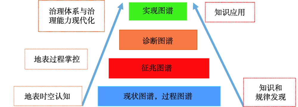
本文回顾和综述了陈述彭院士关于地学信息图谱的学术思想,该学术思想来源于陈先生的科学实践。他提出了地学信息图谱的相关概念及其类型体系,地学信息图谱是地学图谱与现代信息技术结合的产物。地学信息图谱的核心在于发现地学时空知识和规律,并能为社会经济建设提供应用服务。按研究对象划分为地学各分支学科的信息图谱和各行业的信息图谱,按功能划分为:征兆图谱、诊断图谱和实现图谱。陈先生发展了地学信息图谱生成的技术方法,提出了地学信息图谱的工作流程,促进了地学信息图谱在经济社会发展中的应用。陈先生指出了发展地学信息图谱的创新方向:创新地学大数据获取技术方法,提升地学信息图谱生成智能化与自动化水平,促进地学信息图谱应用的深度和广度。陈先生指出网格地图是地学信息图谱的重要基础。该思想至今对推动地球信息科学的发展及其在解决国家重大战略需求方面,仍然具有重要的指导意义。总结了在陈先生地学信息图谱思想的指导下,在地学信息图谱方面的一些实践探索和结果,包括:发展了基于知识发现的专题信息提取和多数据多知识协同的精细地表要素获取的技术方法,提高了水体、绿被、积雪和城乡聚落提取以及精细土地利用和精细植被类型信息获取的自动化水平和效率;拓展了时空变化图谱的研究和应用,提升了时空变化图谱生成的智能化水平和效率;地学信息图谱在社会经济发展、生态建设、环境保护和灾害风险防控等方面的应用实践已展示出了巨大前景。最后,结合新时代共建全球人类命运共同体和地球科学国际化的重大战略需求,提出了开展全球地学信息图谱关键技术与应用研究,以期实现地表大观测到大数据,再到大知识大应用的提升转化,支撑地表治理体系和治理能力的现代化,提升地学服务经济社会发展的水平和能力,彰显学科特色与优势。
杨存建 . 地学信息图谱思想与实践探索[J]. 地球信息科学学报, 2020 , 22(4) : 697 -704 . DOI: 10.12082/dqxxkx.2020.200173
The idea of geo-information Tupu is reviewed and summarized by reading and analyzing the theses published by Academician of Chinese Academy of Sciences, Prof. Chen Shupeng in this paper, which come from his scientific probe into geo-system. Geo-information Tupu is the result of combination of Geo-Tupu and information technology, which aims at discovering spatial and temporal knowledge and rule of geo-science, and can provide service to social and economic construction. Geo-information Tupu is classified into different types for each branch of geo-science and each industry according to its research object, and it is also classified into symptom Tupu, diagnosisTupu and realization Tupu according to its function. Prof. Chen developed the technology method for generating geo-information Tupu, proposed the workflow of geo-information Tupu, promoted the application of geo-information Tupu to the economic and social development. Prof. Chen indicated innovation directions of geo-information Tupu development which include innovation of technology and method of obtaining geo-science big data, improvement of intelligent and automatic level of generating geo-information Tupu, and enhancement of the wide and deep application of geo-information Tupu in social and economic construction. Prof. Chen pointed out grid map is important base of geo-information Tupu. The idea of geo-information Tupu proposed by Prof. Chen still has important guidance value in promoting the advance of geo-information science and meeting the major strategic needs of our country. The exploratory practice and results under the guidance of the idea of geo-information Tupu proposed by Prof. Chen were concluded here. The thematic information extraction technology based on knowledge discovery and the fine geo-surface element acquisition technology based on multi-data and multi-knowledge cooperation have been developed in recent years, which improves the automation level and efficiency of obtaining geo-science elements such as waterbody, settlements, green vegetation cover, snow cover, vegetation and landuse types in detail. The study and application of spatio-temporal change information Tupu have been broaden. The intelligent level and efficiency of generating the spatio-temporal change Tupu have been improved. The application of Geo-information Tupuin in social and economic development, ecological construction, environmental protection and disaster risk prevention and control has shown great prospects in recent years. Finally, in order to meet the major strategic needs of jointly building a global community with a shared future for mankind and the internationalization of geo-science in the new era, this paper puts forward the research on the key technologies and its applications of the global geo-science information Tupu, so that the large knowledge are intelligently and automatically discovered from big data of the geo-system through big observation, and the large knowledge is broadly applied to every aspect and every place through internet, which will support the modernization of the governance system and ability of the geo-surface system, and enhance the level and ability of geo-sciences to serve economic and social development, and highlight the characteristics and advantages of the geoscience.
| [1] |
陈述彭 . 地学的探索第一卷,地理学[M]. 北京: 科学出版社, 1990.
[
|
| [2] |
陈述彭 . 地学的探索第二卷,地图学[M]. 北京: 科学出版社. 1990.
[
|
| [3] |
陈述彭 . 地学的探索第三卷,遥感应用[M]. 北京: 科学出版社, 1990.
[
|
| [4] |
陈述彭 . 地学的探索第五卷,城市化区域发展[M]. 北京, 科学出版社, 2003.
[
|
| [5] |
陈述彭, 周成虎, 陆锋 . 季风热带与亚热带地区的遥感应用实验[J]. 地球信息科学, 2005,7(4):2-4.
[
|
| [6] |
陈述彭 . 新经济时代的西部开发[J]. 地球信息科学, 2001,3(1):2-8.
[
|
| [7] |
陈述彭 . 地学信息图谱刍议[J]. 地理研究, 1998,17(suppl.):5-8.
[
|
| [8] |
陈述彭 . 地学的探索第六卷,地球信息科学[M]. 北京: 科学出版社, 2003.
[
|
| [9] |
陈述彭 . 历史轨迹与知识创新[J]. 地理学报, 2001,56(suppl.):1-7.
[
|
| [10] |
陈述彭, 岳天祥, 励惠国 . 地学信息图谱研究及其应用[J]. 地理研究, 2000,19(4):337-343.
[
|
| [11] |
陈述彭, 陈秋晓, 周成虎 . 网格地图与网格计算[J]. 测绘科学, 2002,27(4):1-6,2.
[
|
| [12] |
杨存建, 徐美, 黄朝永 . 遥感信息机理的水体提取方法的探讨[J]. 地理研究, 1998,17(suppl.):86-89.
[
|
| [13] |
杨存建, 周成虎 . TM影像的居民地信息提取方法研究[J]. 遥感学报, 2000,4(2):146-150,166.
[
|
| [14] |
杨存建, 周成虎 . 基于知识发现的TM图像居民地自动提取研究[J]. 遥感技术与应用, 2001,16(1):1-6.
[
|
| [15] |
杨存建, 赵梓健, 倪静 , 等. 基于MODIS数据的川西积雪时空变化分析[J]. 中国科学:地球科学, 2011,41(12):1743-1750.
[
|
| [16] |
杨存建, 赵梓健, 任小兰 , 等. 基于遥感和GIS的川西绿被时空变化研究[J]. 生态学报, 2012,32(2):632-640.
[
|
| [17] |
杨存建, 周其林, 任小兰 , 等. 基于多时相MODIS数据的四川省森林植被类型信息提取[J]. 自然资源学报, 2014,29(03):507-515.
[
|
| [18] |
杨存建, 王琴, 牟琳 , 等. 基于知识发现的QUICKBIRD影像乡村聚落单元信息提取技术:中国中国, ZL2010 1 0142931.7[P]. 2014-01-08.
[
|
| [19] |
杨存建, 周成虎 . 利用RADARSAT SWA SAR和LANDSAT TM的互补信息确定洪水水体范围[J]. 自然灾害学报, 2001,10(2):79-83.
[
|
| [20] |
杨存建, 魏一鸣, 王思远 , 等. 基于DEM的SAR图像洪水水体的提取[J]. 自然灾害学报, 2002,11(3):121-125.
[
|
| [21] |
姚方方, 骆剑承, 沈占锋 , 等. 高分辨率影像城市植被自动提取算法[J]. 地球信息科学学报, 2016,18(2):248-254.
[
|
| [22] |
李德仁, 张良培, 夏桂松 . 遥感大数据自动分析与数据挖掘[J]. 测绘学报, 2014,43(12):1211-1216.
[
|
| [23] |
李霞, 徐涵秋, 李晶 , 等. 基于NDSI和NDISI指数的SPOT-5影像裸土信息提取[J]. 地球信息科学学报, 2016,18(1):117-123.
[
|
| [24] |
杨存建, 王琴, 倪静 , 等. 多源数据协同的精细森林植被类型信息遥感更新方法:中国, ZL 2010 10275450.3)[P]. 2013-10-08.
[
|
| [25] |
杨存建, 倪静, 何昭霞 , 等. 多源时空数据协同的高精度土地利用遥感更新技术[P]. 中国,获授权日期:2014.5.14.
[
|
| [26] |
杨存建, 刘纪远, 张增祥 , 等. 遥感和GIS支持下的云南省退耕还林还草决策分析[J]. 地理学报, 2001,56(2):181-188.
[
|
| [27] |
杨存建, 刘纪远, 张增祥 , 等. 遥感和GIS支持下的中国退耕还林还草决策分析[J]. 遥感学报, 2002,6(3):205-211.
[
|
| [28] |
杨存建, 冯凉, 徐育建 , 等. 基于ARCGIS的四川省分级退耕还林还草空间决策分析[J]. 自然资源学报, 2007,22(6):986-993.
[
|
| [29] |
杨存建, 冯凉, 杨洪忠 , 等. 四川省林草火险等级评价[J]. 地理研究, 2010,29(6):980-988.
[
|
| [30] |
李春艳, 杨存建, 周其林 , 等. 森林防火减灾信息系统的设计开发——以四川省遂宁市为例[J]. 地球信息科学学报, 2010,12(5):695-699.
[
|
| [31] |
邵全琴, 樊江文, 刘纪远 , 等. 重大生态工程生态效益监测与评估研究[J]. 地球科学进展, 2017,32(11):1174-1182.
[
|
| [32] |
熊俊楠, 李进, 程维明 , 等. 西南地区山洪灾害时空分布特征及其影响因素[J]. 地理学报, 2019,74(7):1374-1391.
[
|
| [33] |
陈述彭, 赵英时 . 遥感地学分析[M]. 北京: 测绘出版社, 1990.
[
|
| [34] |
杨存建, 张果, 陈军 , 等. 基于遥感的成都市及其周边城镇的扩展[J]. 地理研究, 2008,( 1):100-108.
[
|
| [35] |
刘纪远, 宁佳, 匡文慧 , 等. 2010-2015年中国土地利用变化的时空格局与新特征[J]. 地理学报, 2018,73(5):789-802.
[
|
| [36] |
程维明, 高晓雨, 马廷 , 等. 基于地貌分区的1990-2015年中国耕地时空特征变化分析[J]. 地理学报, 2018,73(9):1613-1629.
[
|
| [37] |
|
| [38] |
杨珂含, 姚方方, 董迪 , 等. 青藏高原湖泊面积动态监测[J]. 地球信息科学学报, 2017,19(7):972-982.
[
|
| [39] |
马建威, 黄诗峰, 许宗男 . 基于遥感的1973-2015年武汉市湖泊水域面积动态监测与分析研究[J]. 水利学报, 2017,48(8):903-913.
[
|
| [40] |
周亮, 周成虎, 杨帆 , 等. 2000-2011年中国PM2.5时空演化特征及驱动因素解析[J]. 地理学报, 2017,72(11):2079-2092.
[
|
/
| 〈 |
|
〉 |

