
时空协同的精准农业遥感研究
|
吴志峰(1969— ),男,湖南湘潭人,博士,教授,博士生导师,研究方向为城市遥感与陆地生态遥感、复杂地表格局—过程—效应。E-mail:zfwu@gzhu.edu.cn |
收稿日期: 2019-11-29
要求修回日期: 2019-12-26
网络出版日期: 2020-06-10
基金资助
国家自然科学基金项目(41671430)
国家自然科学基金项目(41631179)
国家自然科学基金青年科学基金项目(41701472)
NSFC-广东联合基金重点项目(U1901219)
版权
Research on Precision Agricultural based on the Spatial-temporal Remote Sensing Collaboration
Received date: 2019-11-29
Request revised date: 2019-12-26
Online published: 2020-06-10
Supported by
National Natural Science Foundation of China(41671430)
National Natural Science Foundation of China(41631179)
National Natural Science Foundation of China Youth Science Foundation Project(41701472)
NSFC-Guangdong Joint Foundation Key Project(U1901219)
Copyright
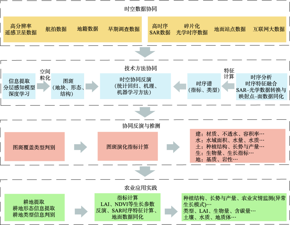
高分辨率遥感对地观测为我们从空间与时间2个维度客观反演地表格局—过程提供了有效的技术支撑。本文遵循时空协同的研究思路,基于高分辨率遥感影像,开展了农业遥感领域2个典型的问题研究:① 提出了一种基于影像视觉特征的耕地分区分层提取方法,该方法在利用DEM数据进行分区的基础上,根据不同区域内耕地所呈现的几何特征和纹理特征差异,分别设计了不同的耕地提取模型;② 构建了一种地块尺度的作物生长参数反演方法,方法以地块为基本单元,在空间、时间及属性组合约束下进行作物理化参数反演。本研究以贵州省安顺市西秀区和广西扶绥县耕地提取进行了耕地地块提取示范,以扶绥县进行了基于耕地地块和中空间分辨率时间序列遥感数据的甘蔗叶面积指数反演。其中,对于安顺市西秀区的耕地地块提取结果而言,形态精度(IoU)大于0.7的地块超过60%,规则耕地、梯田以及林草地等的类型精度均超过了80%;对于扶绥县甘蔗叶面积指数反演的结果而言,其结果可以较为精确地反映出基地甘蔗与非基地甘蔗的差异,基地甘蔗在品质上要优于非基地甘蔗。西南山地区的耕地形态提取/类型判别和地块甘蔗叶面积指数应用验证均证明了方法的可行性。结果表明,协同使用多源高分辨率数据是实现精准农业遥感研究的有效途径。

吴志峰 , 骆剑承 , 孙营伟 , 吴田军 , 曹峥 , 刘巍 , 杨颖频 , 王玲玉 . 时空协同的精准农业遥感研究[J]. 地球信息科学学报, 2020 , 22(4) : 731 -742 . DOI: 10.12082/dqxxkx.2020.190726
High-resolution remote-sensing earth observation provide us with effective technical support for objectively inverting the surface patterns-process from the dimensions of space and time. This paper follows the research idea of space-temporal collaboration, and based on the high-resolution remote sensing images, we explored two typical problems in the agricultural remote sensing field: (1) proposed a division control and stratified extraction method for geo-parcel based on visual characteristics of images. Based on the division of DEM, we have designed different geo-parcel extraction models based on the differences in geometric and texture features in the division regions; (2) proposed a method for crop growth parameters inversing at the geo-parcel scale. Geo-parcel is the basic unit to perform physical parameter inversion under the constraints of space-time-attribute combination. The study taking geo-parcels extraction in in Xixiu District of Anshun City in Guizhou Province and Fusui County in Guangxi as examples for the division control and stratified extraction method, and taking inversion of sugarcane leaf area index in Fusui County of Guangxi Province as examples for the method of crop growth parameters inversing at the geo-parcel scale. For the extraction of cultivated land in Xixiu District, The number of geo-parcels with morphological accuracy (IoU) greater than 0.7 accounts for more than 60%, and the accuracy of the types of regular geo-parcels, terraces, forests and grasslands exceeded 80%; also, for the inversion results of sugarcane leaf area index in Fusui County, the results can accurately reflect the difference between base sugarcane and non-base sugarcane, and the base sugarcane is superior in quality to non-base sugarcane. It shows that Spatial-temporal collaboration use of multi-source high-resolution data is an effective way to achieve accurate agricultural remote sensing research.

表1 PROSAIL模型输入参数Tab. 1 input parameters for PROSAIL model |
| 参数 | 符号 | 范围 | 个数 | 分布 |
|---|---|---|---|---|
| 太阳天顶角/° | ϴs | - | 1 | 固定值 |
| 观测天顶角/° | ϴv | - | 1 | 固定值 |
| 相对方位角/° | Φ | - | 1 | 固定值 |
| 叶面积指数/(m2/m2) | LAI | 0.1~6 | 25 | 均匀分布 |
| 平均叶倾角/° | ALA | 20~70 | 5 | 均匀分布 |
| 热点参数 | Hot | 0.05~0.5 | 5 | 均匀分布 |
| 散射光比例 | skyl | - | 1 | 固定值 |
| 土壤相对湿度 | αsoil | 0.0~1.0 | 5 | 均匀分布 |
| 叶绿素a/b浓度/(μg/cm2) | Cab | 5~100 | 22 | 均匀分布 |
| 胡萝卜素浓度/(μg/cm2) | Car | 0.001~25 | 3 | 均匀分布 |
| 等效水分厚度/cm | Cw | 0.001~0.05 | 3 | 均匀分布 |
| 干物质含量/(g/cm2) | Cm | 0.001~0.02 | 5 | 均匀分布 |
| 棕色素相对含量 | Cbp | 0 | 1 | 固定值 |
| 叶片结构参数 | N | 1~3 | 5 | 均匀分布 |
| [1] |
吴炳方, 蒙继华, 李强子 . 国外农情遥感监测系统现状与启示[J]. 地球科学进展, 2010,25(10):1003-1012.
[
|
| [2] |
史舟, 梁宗正, 杨媛媛 , 等. 农业遥感研究现状与展望[J]. 农业机械学报, 2015,46(2):247-260.
[
|
| [3] |
|
| [4] |
|
| [5] |
蒙继华, 吴炳方, 杜鑫 , 等. 遥感在精准农业中的应用进展及展望[J]. 国土资源遥感, 2011,23(3):1-7.
[
|
| [6] |
刘亮, 姜小光, 李显彬 , 等. 利用高光谱遥感数据进行农作物分类方法研究[J]. 中国科学院研究生院学报, 2006,23(4):484-488.
[
|
| [7] |
蒙继华, 付伟, 徐晋 , 等. 遥感在种植业保险估损中的应用[J]. 遥感技术与应用, 2017,32(2):238-246.
[
|
| [8] |
邵美珍, 邓广林, 徐希孺 . 基于主成分分析的混合象元分解[J]. 中国空间科学技术, 1989,9(5):63-68.
[
|
| [9] |
|
| [10] |
|
| [11] |
|
| [12] |
|
| [13] |
|
| [14] |
|
| [15] |
李秦, 高锡章, 张涛 , 等. 最优分割尺度下的多层次遥感地物分类实验分析[J]. 地球信息科学学报, 2011,13(3):409-417.
[
|
| [16] |
|
| [17] |
黄慧萍 . 面向对象影像分析中的尺度问题研究[D]. 北京:中国科学院研究生院, 2003.
[
|
| [18] |
|
| [19] |
王金甲, 陈浩, 刘青玉 . 大数据下的深度学习研究[J]. 高技术通讯, 2017,27(1):27-37.
[
|
| [20] |
|
| [21] |
|
| [22] |
|
| [23] |
|
| [24] |
|
| [25] |
|
| [26] |
刘浩, 骆剑承, 黄波 , 等. 基于特征压缩激活Unet网络的建筑物提取[J/OL]. 地球信息科学学报, 2019,21(11):1-11.
[
|
| [27] |
吴炳方, 张峰, 刘成林 , 等. 农作物长势综合遥感监测方法[J]. 遥感学报, 2004,8(6):498-514.
[
|
| [28] |
李峰, Alchanatis Victor, 赵红 , 等. 基于PLSR方法的马铃薯叶片氮素含量机载高光谱遥感反演[J]. 中国农业气象, 2014,35(3):338-343.
[
|
| [29] |
郭琳, 裴志远, 张松龄 , 等. 基于环境星CCD图像的甘蔗叶面积指数反演方法[J]. 农业工程学报, 2010,26(10):201-205.
[
|
| [30] |
甘海明, 岳学军, 洪添胜 , 等. 基于深度学习的龙眼叶片叶绿素含量预测的高光谱反演模型[J]. 华南农业大学学报, 2018,39(3):108-116.
[
|
| [31] |
马茵驰, 阎广建, 丁文 , 等. 基于人工神经网络方法的冬小麦叶面积指数反演[J]. 农业工程学报, 2009,25(12):187-192.
[
|
| [32] |
李宗南, 陈仲新, 王利民 , 等. 基于ACRM模型不同时期冬小麦LAI和叶绿素反演研究[J]. 中国农业资源与区划, 2012(1):3-7.
[
|
| [33] |
陈述彭, 岳天祥, 励惠国 . 地学信息图谱研究及其应用[J]. 地理研究, 2000,19(4):337-343.
[
|
| [34] |
赵英时 . 遥感应用分析原理与方法[M]. 北京: 科学出版社, 2013.
[
|
| [35] |
|
| [36] |
|
| [37] |
邵芸, 郭华东, 范湘涛 , 等. 水稻时域散射特征分析及其应用研究[J]. 遥感学报, 2001,5(5):340-345.
[
|
| [38] |
化国强, 王晶晶, 黄晓军 , 等. 基于全极化SAR数据散射机理的农作物分类[J]. 江苏农业学报, 2011,27(5):978-982.
[
|
| [39] |
王迪, 周清波, 陈仲新 , 等. 基于合成孔径雷达的农作物识别研究进展[J]. 农业工程学报, 2014,30(16):203-212.
[
|
| [40] |
向海燕 . 基于光学和SAR数据的多云雾山区土地覆被分类[D]. 重庆:西南大学, 2018.
[
|
| [41] |
|
| [42] |
骆剑承, 吴田军, 吴志峰 , 等. 地理图斑智能计算及模式挖掘方法研究[J]. 地球信息科学学报, 2020,22(1):57-75.
[
|
/
| 〈 |
|
〉 |