自然和自然贡献情景模型研究综述

  • 岳天祥 , 1, 2, * ,
  • 范泽孟 , 1, 2, * ,
  • 史文娇 1, 2 ,
  • 赵娜 1, 2
展开
  • 1. 中国科学院地理科学与资源研究所 资源与环境信息系统国家重点实验室,北京 100101
  • 2. 中国科学院大学资源与环境学院,北京 100049
* 范泽孟(1977— ),男,云南镇雄人,博士,副研究员,研究方向为生态模型与系统模拟、土地覆盖情景建模及生物多样性模拟。E-mail:

岳天祥(1963— ),男,甘肃庆阳人,博士,研究员,主要研究方向为资源环境模型与系统模拟、生态环境信息学。

收稿日期: 2020-04-05

  要求修回日期: 2020-04-20

  网络出版日期: 2020-06-10

基金资助

国家自然科学基金项目(41930647)

国家自然科学基金项目(1590844)

国家自然科学基金项目(41421001)

国家自然科学基金项目(41971358)

中国科学院A类先导专项项目(XDA20030203)

资源与环境信息系统国家重点实验室自主创新项目(O88RA600YA)

生态环境部生物 多样性调查、观测和评估项目(2019 — 2023年)()

版权

版权所有,未经授权,不得转载、摘编本刊文章,不得使用本刊的版式设计。

Models and Scenarios for Nature and Nature's Contribution

  • YUE Tianxiang , 1, 2, * ,
  • FAN Zemeng , 1, 2, * ,
  • SHI Wenjiao 1, 2 ,
  • ZHAO Na 1, 2
Expand
  • 1. State Key Laboratory of Resources and Environment Information System, Institute of Geographic Sciences and Natural Resources Research, Chinese Academy of Sciences, Beijing 100101, China
  • 2. College of Resources and Environment, University of Chinese Academy of Sciences, Beijing 100049, China
* YUE Tianxiang, E-mail: ;
FAN Zemeng, E-mail:

Received date: 2020-04-05

  Request revised date: 2020-04-20

  Online published: 2020-06-10

Supported by

National Natural Science Foundation of China(41930647)

National Natural Science Foundation of China(1590844)

National Natural Science Foundation of China(41421001)

National Natural Science Foundation of China(41971358)

Strategic Priority Research Program(A) of the Chinese Academy of Sciences(XDA20030203)

Innovation Project of LREIS(O88RA600YA)

Biodiversity Investi- gation, Observation and Assessment Program (2019-2023) of the Ministry of Ecology and Environment of China()

Copyright

Copyright reserved © 2016

摘要

本文回顾了自然和自然贡献情景模型发展的背景、历史和内容,概括总结了自然和自然贡献情景模型的发展进程以及联合国生物多样性与生态系统服务政府间科学—政策平台(IPBES)情景模型的概念框架,讨论了自然和自然贡献情景模型存在的问题和发展方向。为了在全球层面解决现有综合集成模型存在的问题,根据地球表层建模基本定理和生态环境曲面建模基本定理,提出了具有中国原创特点的自然与自然贡献情景模型概念框架。

本文引用格式

岳天祥 , 范泽孟 , 史文娇 , 赵娜 . 自然和自然贡献情景模型研究综述[J]. 地球信息科学学报, 2020 , 22(4) : 743 -750 . DOI: 10.12082/dqxxkx.2020.200163

Abstract

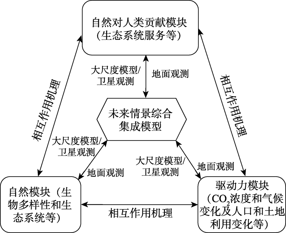
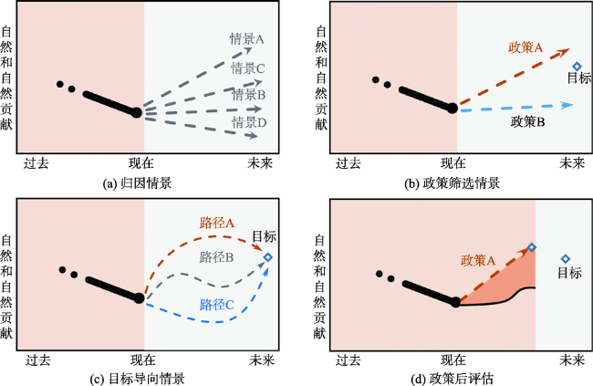
In April 2012, a resolution was adopted for establishing "Intergovernmental science-policy Platform for Biodiversity and Ecosystem Services (IPBES)" as an independent intergovernmental body of United Nations (UN) according to the UN Office of Legal Affairs with the seat of the secretariat located in Bonn of Germany.IPBES has 136 members now and is continuously growing. China has formally joined IPBES after State Council of the People's Republic of China gave its stamp of approval in December of 2012. In order to guide the use of scenario analysis and modelling in all work under IPBES to ensure the policy relevance of its deliverables, 'the methodological assessment report on scenarios and models of biodiversity and ecosystem services' was firstly started up in early 2014, which was carried out by experts from all regions of the world. Its summary for policy-makers was approved by the fourth session of the Plenary of IPBES in February 2016 and has been launched in August 2016 in France. Nature, nature's contribution to people and driving forces of nature change are core concepts of the methodological assessment report. Nature includes biodiversity and ecosystems as well as earth system. Nature's contribution to people consists of ecosystem services and nature's gifts. Driving forces of nature change was classified into direct driving forces and indirect driving forces. Advanced work on scenarios and models of biodiversity and ecosystem services is one of deliverables of the work program up to 2030. We review background, history and contents of the scenarios and models of biodiversity and ecosystem services, describe the conceptual framework of IPBES scenarios include exploratory scenarios/attribution scenarios, policy-screening scenarios, target-seeking scenarios and retrospective policy evaluation, and discuss existing problems and perspectives for developing the models and scenarios. To find a solution for these existing problems on global level, a conceptual model is proposed for integrating dynamics of nature, changes of nature's contribution to people, and driving forces of the changes in terms of the fundamental theorem for Earth's surface system modeling. In the meanwhile, interactive mechanisms among nature, nature's contribution and driving forces are considered, along with combination of macro-pattern information and micro-process information.

1 引言

陈述彭先生曾指出:模型是人类的数学思维方式之一。没有数学模型,人们辛勤获取的大量数据就像一盘散沙,找不出其中哪些是璀璨的金粒,哪些能显示出本质性规律,从中提取有效的信息,升华成为科学知识[1]
2001年6月,联合国秘书长安南宣布启动了为期4年的“千年生态系统评估(Millennium Ecosystem Assessment,MA)”国际合作项目,其目标是对生态系统及其服务的变化趋势进行科学评价,并为保护和持续利用生态系统及其服务的行动提供科学支撑。2005年3月30日,“中国西部生态系统综合评估(MAWEC)”亚全球项目的中英文报告与国际MA评估报告同时在北京正式发布[2,3]
MA评估结果表明,生物多样性和生态系统服务正在以史无前例的速率下降。为了加强科技界、政府和其他利益相关者在生物多样性和生态系统服务方面的沟通与对话,作为MA后续行动的重要部分,2005年1月在以“生物多样性、科学与管理”为主题的巴黎会议上,建议对生物多样性科学评价国际机制的必要性、范围和可能形式进行磋商[4]
作为响应千年生态系统评估(MA)磋商过程的结果,在2011年2月召开的第26届联合国环境规划署理事会会议上,讨论了第65届联合国会员大会通过的关于成立“生物多样性与生态系统服务政府平台”(Intergovernmental Platform on Biodiversity and Ecosystem Services,IPBES)决议,并于2012年4月成立了向联合国所有成员国开放的“生物多样性与生态系统服务政府间科学—政策平台”(https://ipbes.net)。
IPBES在联合国环境规划署、联合国教科文组织、联合国粮农组织和联合国开发计划署的支持下,在联合国环境规划署的管理下,根据决策者需要,评估生物多样性和生态系统服务的状态。IPBES的主要任务是:为了生物多样性保护和持续利用及长期人类福祉和可持续发展,加强生物多样性和生态系统服务的科学与政策联系。中国于2012年12月经国务院批准,正式加入生物多样性和生态系统服务政府间科学—政策平台。目前,IPBES已有136个成员国。2014年初,启动了作为IPBES的首批评估活动之一的“生物多样性和生态系统服务情景模型方法评估”(简称《IPBES情景模型评估》)[5],并于2016年初完成。在2016年2月召开的第四届“生物多样性与生态系统服务政府间科学—政策平台”全体会议上,讨论通过了“情景模型评估”报告。2016年8月25日“情景模型评估”报告及其决策者摘要在法国蒙彼利埃正式向全球发布。
《IPBES情景模型评估》[5]结果表明,情景模型是预见自然对人类各种发展途径和政策选择响应的有效利器。虽然大多数全球环境评估情景模型探讨了社会对自然的影响,但是它们没有将自然作为社会经济发展的核心要素给予考虑,忽视了自然保护的政策目标及自然在基础发展和人类福祉中的重要作用。由于人类发展目标越来越与自然目标息息相关,因此现有的情景模型已不能适应可持续发展决策支持需求。
鉴于以上问题,IPBES于2016年8月在法国蒙彼利埃市召开了“生物多样性与生态系统服务决策支持情景与模型”研讨会,推动新一代情景模型的研发。其目标是实现自然保护和发展目标的平衡与协同,提高自然、自然对人类贡献和人类福祉之间相互作用的模拟分析能力。2017年9月在新西兰奥克兰市召开了“自然和自然对人类贡献的21世纪新篇章”研讨会,讨论了“以自然为核心的情景模型”框架。2018年6月25—28日,IPBES情景模型专家组技术支持单位与专家组共同主席在荷兰海牙组织召开了“自然未来发展的下一步计划”研讨会。会议主要目的包括3个方面:① 分析奥克兰会议初步设想的重叠内容和主要缺口;② 推进IPBES情景发展的详细工作计划;③ 自然未来框架的发展。2019年3月25—27日,在加拿大温哥华召开了“从幻想到自然和自然对人类贡献的21世纪情景”研讨会。主要讨论了3个方面内容:① 如何定量表达未来情景的具体脉络;② 识别可用于评估自然未来情景轨迹的指标;③ 勾画每个未来情景与每个指标期望目标(例如,联合国可持续发展目标)的关系。
自然和自然贡献情景模型是联合国IPBES第二轮(2020—2030)工作方案的优先主题之一,也是第二轮全球、区域、国家和局地等多尺度评估的基本手段。

2 情景模型研究进展

1967年,Kahn 和Wiener发表了他们关于情景的开创性工作[6]。在罗马俱乐部关于增长极限的报告中,虽然没有使用情景一词,但他们的条件展望计算(Conditional Forward Calculations)与现在的未来情景发挥着类似作用[7]。21世纪初以来,每年至少有300篇关于情景分析的学术论文发表[8]。与此同时,情景分析在全球环境评估中得到广泛应用,例如,联合国政府间气候变化专门委员会评估报告[9,10,11],联合国环境规划署全球环境展望[12,13,14],千年生态系统评估[4]和亚全球评估报告[2,3],农业水管理综合评估[15],农业知识、科学和技术发展国际评估[16],以及生物多样性和生态系统服务情景与模型的方法评估报告[5]
以往绝大多数研究聚焦于探索情景。例如,Schroeter等[18]基于社会经济、大气温室气体浓度、气候和土地利用等全球变化驱动力情景,运用全球植被动态模型(DGVM),模拟了全球变化对欧洲碳储量和食物生产等生态系统服务的影响。Swetnam等[19]运用基于布尔规则的地理信息系统模型描绘了坦桑尼亚东部弧形山脉的2000—2025年碳储量情景。Okruszko等[20]通过全球水评估和诊断(WaterGAP)模型与大气环流模型(GCMs)的耦合,模拟了基于气候变化驱动力情景的欧洲湿地生态系统21世纪50年代情景。Estoque和Murayama[21]运用基于地理信息系统的土地利用变化模型(GEOMOD)分析了菲律宾碧瑶市2020年土地利用变化驱动的生态系统服务情景。Walz等[22]通过识别生态系统变化驱动力和定义每个驱动力的可能未来状态,估算驱动力与生态系统状态变量之间的相互作用关系,模拟分析了瑞士山区生态系统服务的2050年情景。Kirchner等[23]为了量化农业生态系统服务和经济发展,研发了一个集成建模框架,并以奥地利为案例,评估了不同农业政策途径和区域气候情景对2008—2040年生态系统服务的各种影响。
Thompson等[24]通过耦合土地利用与景观模型(LANDIS-II)模拟了土地利用情景及其与预期气候变化的相互作用,估算了2010—2060年马萨诸塞州可能的生态系统服务量级和空间分布。Landuyt等[25]通过耦合元胞自动机土地利用变化模型与生态系统服务贝叶斯置信网络模型,分析了社会经济发展对比利时佛兰德斯地区2050年食物供给、木材产量和空气质量调节等生态系统服务的可能影响。Berg等[26]基于人文和气候驱动力,模拟分析了美国新罕布什尔州地区生态系统服务的2025年情景。Outeiro等[27]运用生态系统服务及其权衡综合评价模型(InVEST),发展了智利南部洛斯拉戈斯海域生态旅游和濒危物种的未来情景。Kremer等[28]运用多指标分析(MCA)法,评价分析了纽约市雨水吸收、碳储量、空气污染清除、局地气候调节和休闲娱乐等生态系统服务的空间精准未来情景。
目前,未来情景主流模型主要包括全球环境评价集成模型(Integrated Model to Assess the Global Environment, IMAGE)、全球生物多样性模型(Global Biodiversity Model, GLOBIO)、全球生物圈管理模型(Global Biosphere Management Model, GLOBIOM)、生物圈全球统一元模型(Global Unified Meta-model of the Biosphere, GUMBO)、生态系统服务多尺度集成模型(Multi-scale Integrated Model of Ecosystem Services, MIMES)、全球植被动态模型(Dynamic Global Vegetation Model, DGVM)、土地利用转换及其影响模型(Conversion of Land Use and its Effects, CLUE)、生态模拟通道模型(Ecopath with Ecosim, EwE)、生态系统服务及权衡综合评价模型(Integrated Valuation of Ecosystem Services and Trade-offs, InVEST)、生态服务人工智能模型(Artificial Intelligence for Ecosystem Services, ARIES)和地球系统模型(Earth System Model, ESM)等。
全球环境评价集成模型(IMAGE)由生态系统服务模块以及能源—产业模块、陆地环境模块和大气-海洋模块组成,主要用于评价间接驱动力情景和模拟直接驱动力与间接驱动力之间的相互关系[29,30]。IMAGE已被运用于支撑诸如联合国政府间气候变化专门委员会(IPCC)评估、联合国环境规划署(UNEP)的全球环境展望、经济合作与发展组织(OECD)的环境展望和千年生态系统评估(MA)各种国际评估,并被广泛用于科学研究。
全球生物多样性模型(GLOBIO)是计算环境驱动力对生物多样性过去、现在和未来影响的建模框架,由陆地生态系统模型和淡水环境模型构成。它的输入主要来自全球环境评价集成模型(IMAGE)。全球生物多样性模型的当前版本GLOBIO3仅限于不包括南极洲的全球陆地部分。全球生物多样性模型可用于评估环境驱动力对平均物种丰富度(Mean Species Abundance, MSA)的影响、各种未来情景下的可能变化趋势及各种响应或政策选择的可能影响[31]
全球生物圈管理模型(GLOBIOM)是由国际应用系统分析研究所(IIASA)开发的部分均衡经济模型,用于阐述农业、生物能源和林业生产部门在土地利用变化过程中的相互作用,涉及18种最重要的农作物、7种畜产品、林业系统和生物能源供应链,涵盖全球30个区域。在综合地理空间数据库的支持下,可模拟10年间隔的2100年以前未来情景[32]
生物圈全球统一元模型(GUMBO)是最早的系统动力学模型之一。生物圈全球统一元模型由大气圈、岩石圈、水文圈、生物圈和人类圈5个模块组成,地球表面被划分为海洋、沿海、森林、草地、湿地、河/湖、沙漠、苔原、冰/石、耕地和城市11种生态系统类型,模拟生态系统服务及其对全球经济和人类福利的影响[33]
生态系统服务多尺度集成模型(MIMES)源于生物圈全球统一元模型(GUMBO)的发展,通过集成各种知识,模拟生态系统服务的得失。生态系统服务多尺度集成模型将类似的系统要素组合为模块,每个模块分别描绘自然和人类系统的一组过程。在应用过程中,这些模块可以进行耦合,用于分析各模块之间的相互作用和反馈。其基本内容包括圈层、资源、生产函数、影响函数、需求表和未来情景[34]
全球植被动态模型(DGVM)用以模拟各种生物地理化学、生物地理物理和水文过程[35]。它运用时间序列气候数据,在纬度、地形和土壤特征等约束条件下,模拟月时间尺度或日时间尺度生态系统过程动态,是模拟未来气候变化对自然植被、碳和水循环的最常用手段。
土地利用转换及其影响模型(CLUE)基于农业发展和自然保护2种情景,模拟分析每个像元上不同土地利用类型的未来需求分配[36]。在模拟分析过程中,土地类型被区分为在区域层面需求驱动(如农业用地、城市用地和经济林地)和在区域层面无法确定聚合需求(如自然和半自然土地覆被) 2组。在迭代比较每种土地类型分配面积的过程中,在区域层面将土地利用类型分配到每个像元,直到满足需求时迭代终止。
生态模拟通道模型(EwE)是一种区域动态过程模型,主要用于动态描绘海洋和水生生态系统能流。生态模拟通道模型由“生态通道(Ecopath)”、“生态模拟(Ecosim)”和“生态空间(Ecospace)”3个相互联系的部分组成。“生态通道”描绘生态系统生物量储量和通量的物质平衡静态片段,“生态模拟”通过运用一套微分方程计算捕食、消费和渔获率来描绘生物量及其通量随时间的变化,“生态空间”则对生态系统进行时空动态模拟以探索渔业管理政策的空间效应[37,38]
生态系统服务及权衡综合评价模型(InVEST)是一套广泛使用的区域静态过程关联模型,它基于生物物理过程的简化表达,描绘生态系统结构和功能如何影响生态系统服务和价值。它是基于未来价格和成本假设的生物物理和经济模型,可用于识别当前景观和未来情景下生态系统服务和价值的空间格局以及管理情景的权衡[39]
生态服务人工智能(ARIES)是一个区域动态专家模型,它将多尺度过程与贝叶斯模型相结合,可对任何生态系统服务进行空间模拟[40]。由于ARIES 可以通过网络界面进行访问,因此不需要商业地理信息系统和模拟软件,可通过在线生态系统服务搜索演示,测绘碳储量、淡水供应、洪水调节、沉积调节、生计渔业和旅游观光等生态系统服务。
地球系统模型(ESM)是全球气候模型的扩展,是一种陆地和海洋生态系统服务及生物地理化学循环的模拟模型[41]。全球气候模型由大气、海洋和海冰动态及陆地水文气象表达,陆地和海洋与大气通过能量和动量通量耦合;而地球系统模型在全球气候模型基础上,增加了碳循环、陆地和海洋生态系统、生物地理化学和大气化学以及自然和人类干扰等。
其他用于量化生态系统服务的模型包括生态系统服务共同审核(Corporate Ecosystem Services Review,ESR)、生态系统服务样地评估(Ecosystem Service Site-based Assessment,TESSA)、自然成本估算(Costing Nature)和土地利用与容量指标(Land Utilisation and Capability Indicator,LUCI)。ESR是由世界资源研究所(World Resources Institute)研发的定性方法,用于考虑千年生态系统评估(MA)列举的27种生态系统服务功能[42]。TESSA运用决策树引导用户迅速识别生态系统服务的优先顺序,为特定案例提供评估模板[43]。LUCI聚焦于农业景观和生态系统服务,可利用简单算法识别生态系统服务,并向利益相关者和决策者提供生态系统服务权衡信息[44]
自2001年以来,中国在生态系统评估模型方面取得了不少成果。2001年5月,为了配合联合国千年生态系统评估(MA)的实施,启动了中国西部生态系统综合评估研究项目,同时也被联合国MA确定为首批启动的五个亚全球区域评估项目之一。在此项目支持下,建立了高精度曲面建模(HASM)方法,并被成功运用于中国西部生态系统服务变化及其驱动力未来情景模拟分析[2,3]。近年来,为了形成中国统一的指标体系和技术方法,使不同区域间的评估结果具有可比性,构建了中国生物多样性与生态系统服务评估指标体系和相应模型[45,46]

3 问题与展望

根据联合国IPBES概念框架,情景包括归因情景(Exploratory scenarios/attribution scenarios)、政策筛选情景(Policy-screening scenarios)、目标导向情景(Target-seeking scenarios)和政策后评估(Retrospective policy evaluation)[5]。归因情景根据驱动力的可能轨迹,分析自然对人类贡献的可能未来(图1(a));政策筛选情景通过对备选政策或管理措施对环境影响的预测,对备选政策进行事前评估(图1(b));目标导向情景在对明确定义目标的基础上,通过优化目标函数,识别达到目标的不同路径(图1(c));政策后评估根据对过去已执行政策轨迹的观测,与计划达到既定目标的轨迹进行比较,对其偏差进行分析(图1(d))。
图1 联合国IPBES框架下的情景概念

Fig.1 Concepts of scenarios under the IPBES framework

按照联合国IPBES的情景概念模型,需要进行模型耦合,以集成生态系统的不同方面。按照模型的耦合程度,可分为模型的松散耦合和集成[47]。模型松散耦合的优势是可以保留每个专业模型的专项长处,劣势是缺乏所模拟要素之间的反馈以及不同模型对同一现象会出现矛盾表达。另外,松散耦合可能会在被耦合模型之间传播误差,而且这些被传播的误差往往难以被跟踪和量化[48]
模型集成是最紧凑的无缝模型耦合,它以一致的方式将不同模型表达系统镶嵌在一起。第三次IPCC评估报告将集成评估模型定义为“组合、解释和表达自然和社会科学多学科知识的跨学科过程,旨在研究和认识复杂系统之间和系统内部的因果关系”[9]。在具体实践中,选择模型集成还是模型松散耦合,取决于评估的特定需求和研究对象的系统特征。如果系统要素之间或不同空间尺度之间的相互反馈对模拟产出比较重要时,选择模型集成较好;如果个别要素主导系统动态,则模型松散耦合更适合于捕捉这种动态。
集成模型的基本特征之一就是同时考虑了环境问题多个方面。在全球层面,集成模型是对模拟不同驱动力下自然和自然动态的潜在有效工具,但目前的集成模型尚未具备这个能力[49,50]。自然和自然贡献与驱动力之间缺乏相互反馈是目前集成模型又一个值得注意的局限性。为此,我们根据地球表层建模基本定理和生态环境曲面建模基本定理[51,52,53,54],提出了具有中国原创特点的自然与自然贡献情景模型概念框架(图2)。它由自然模块、自然贡献模块和驱动力模块组成,嵌入了各模块之间的相互反馈机制以及宏观格局信息与微观过程信息的综合功能。
图2 自然与自然贡献情景模型概念框架

Fig.2. The framework for modeling scenarios of nature and nature's contribution

[1]
陈述彭 . 序言[M]//岳天祥.资源环境数学模型手册. 北京: 科学出版社, 2003.

[ Chen S P . Preface[M]// Yue T X. Handbook on mathematical models of resources and environment. Beijing: Science Press, 2003. ]

[2]
刘纪远, 岳天祥, 鞠洪波 , 等. 中国西部生态系统综合评估[M]. 北京: 气象出版社, 2006.

[ Liu J Y, Yue T X, Ju H B , et al. Integrated ecosystem assessment of western China[M]. Beijing: China Meteorological Press, 2006. ]

[3]
Liu J Y, Yue T X, Ju H B , et al. Integrated ecosystem assessment of western China[M]. Beijing: China Meteorological Press, 2005.

[4]
MA. Millennium ecosystem assessment-synthesis report[M]. Washington, DC: Island Press, 2005.

[5]
IPBES. The methodological assessment report on scenarios and models of biodiversity and ecosystem services[M]. Bonn, Germany: Secretariat of the Intergovernmental Science-Policy Platform on Biodiversity and Ecosystem Services, 2016.

[6]
Kahn H, Wiener A J . The year 2000: A framework for speculation on the next thirty-three years[M]. New York: MacMillan, 1967.

[7]
Meadows D H, Meadows D L, Randers J , et al. The Limits to Growth: A report to the club of Rome[M]. New York, USA: Universe Books, 1972.

[8]
Pulver S, van Deveer S . Thinking about tomorrow: Scenarios, social science and global environmental politics[J]. Global Environmental Politics, 2009,9(2):1-13.

[9]
IPCC. Climate change 2001: Synthesis report[M]. Cambridge: Cambridge University Press, 2001.

[10]
IPCC. Climate change 2007 - Synthesis report. Contribution of Working Groups I, II and III to the Fourth Assessment Report of the Intergovernmental Panel on Climate Change[M]. Cambridge: Cambridge University Press, 2007.

[11]
IPCC. Climate Change 2014: Synbook Report. Contribution of Working Groups I, II and III to the Fifth Assessment Report of the Intergovernmental Panel on Climate Change[M]. Geneva, Switzerland: IPCC, 2014.

[12]
UNEP. Global environment outlook 3[M]. London: EarthScan, 2002.

[13]
UNEP. Global environment outlook 4[M]. Nairobi: UNEP, 2007.

[14]
UNEP. Global environment outlook 5[M]. Geneva: UNEP, 2012.

[15]
CA. Water for food, water for life: A comprehensive assessment of water management in agriculture[M]. London: Earthscan, 2007.

[16]
Watson B. International assessment of agricultural science and technology development[M]. Washington, DC: Island Press, 2009.

[17]
van Vuuren D P, Kok M T J, Girod B, Lucas P L , et al. Scenarios in global environmental assessments: Key characteristics and lessons for future use[J]. Global Environmental Change, 2012,22:884-895.

[18]
Schroeter D, Cramer W, Leemans R, Prentice I C , et al. Ecosystem service supply and vulnerability to global change in Europe[J]. Science, 2005,310:1333-1337.

[19]
Swetnam R D, Fisher B, Mbilinyi B P , et al. Mapping socio-economic scenarios of land cover change: A GIS method to enable ecosystem service modeling[J]. Journal of Environmental Management, 2011,92:563-574.

[20]
Okruszko T, Duel H, Acreman M , et al. Broad-scale ecosystem services of European wetlands: Overview of the current situation and future perspectives under different climate and water management scenarios[J]. Hydrological Sciences Journal, 2011,56(8):1501-1517.

[21]
Estoque R C, Murayama Y . Examining the potential impact of land use/cover changes on the ecosystem services of Baguio city, the Philippines: A scenario- based analysis[J]. Applied Geography, 2012,35:316-326.

[22]
Walz A, Braendle J M, Lang D J , et al. Experience from downscaling IPCC-SRES scenarios to specific national-level focus scenarios for ecosystem service management[J]. Technological Forecasting & Social Change, 2014,86:21-32.

[23]
Kirchner M, Schmidt J, Kindermann G , et al. Ecosystem services and economic development in Austrian agricultural landscapes: The impact of policy and climate change scenarios on trade-offs and synergies[J]. Ecological Economics, 2015,109:161-174.

[24]
Thompson J R, Lambert K F, Foster D R , et al. The consequences of four land-use scenarios for forest ecosystems and the services they provide[J]. Ecosphere, 2016,7(10): e01469.10.1002/ecs2. 1469.

[25]
Landuyt D, Broekx S, Engelen G , et al. The importance of uncertainties in scenario analyses: A study on future ecosystem service delivery in Flanders[J]. Science of the Total Environment, 2016,553:504-518.

[26]
Berg C, Rogers S, Mineau M . Building scenarios for ecosystem services tools: Developing a methodology for efficient engagement with expert stakeholders[J]. Futures, 2016,81:68-80.

[27]
Outeiro L, Haessermann V, Viddi F , et al. Using ecosystem services mapping for marine spatial planning in southern Chile under scenario assessment[J]. Ecosystem Services, 2015,16:341-353.

[28]
Kremer P, Hamstead Z A, McPhearson T . The value of urban ecosystem services in New York City: A spatially explicit multicriteria analysis of landscape scale valuation scenarios[J]. Environmental Science & Policy, 2016,62:57-68.

[29]
岳天祥 . 资源环境数学模型手册[M]. 北京: 科学出版社, 2003.

[ Yue T X . Mathematical Model Manual of Resource and Environment[M]. Beijing: Science Press, 2003. ]

[30]
Stehfest E, Van Vuuren D, Kram T , et al. Integrated assessment of global environmental change with IMAGE 3.0. Model description and policy applications[M]. The Hague, PBL Netherlands: Environmental Assessment Agency, 2014.

[31]
Alkemade R, Van Oorschot M, Miles L , et al. GLOBIO3: A framework to investigate options for reducing global terrestrial biodiversity loss[J]. Ecosystems, 2009,12(3):374-390.

[32]
Skalský R, Tarasovičová Z, Balkovič J , et al. GEO-BENE global database for bio-physical modeling v.1.0. Concepts, methodologies and data[M]. Laxenburg, Austria: IIASA, The GEO-BENE database report, 2008.

[33]
Boumans R, Costanza R, Farley J , et al. Modeling the dynamics of the integrated earth system and the value of global ecosystem services using the GUMBO model[J]. Ecological Economics, 2002,41(3):529-560.

[34]
Boumans R, Roman J, Altman I , et al. The Multiscale Integrated Model of Ecosystem Services (MIMES): Simulating the interactions of coupled human and natural systems[J]. Ecosystem Services, 2015,12:30-41.

[35]
Smith B, Prentice I C, Sykes M T . Representation of vegetation dynamics in the modelling of terrestrial ecosystems: Comparing two contrasting approaches within European climate space[J]. Global Ecology and Biogeography, 2001,10(6):621-637.

[36]
Verburg P, Overmars K . Combining top-down and bottom-up dynamics in land use modeling: Exploring the future of abandoned farmlands in Europe with the Dyna-CLUE model[J]. Landscape Ecology, 2009,24(9):1167-1181.

[37]
Christensen V, Walters C J . Ecopath with Ecosim: Methods, capabilities and limitations[J]. Ecological Modelling, 2004,172(2-4):109-139.

[38]
Christensen V, Walters C J, Pauly D . Ecopath with Ecosim: A User's Guide[M]. Vancouver, Canada: Fisheries Centre, University of British Columbia, 2005.

[39]
Kareiva P, Tallis H, Ricketts T H , et al. Natural capital: Theory and practice of mapping ecosystem services[M]. Oxford: Oxford University Press, 2011.

[40]
Villa F, Bagstad K J, Voigt B , et al. A methodology for adaptable and robust ecosystem services assessment[J]. PLoS One, 2014,9(3):e91001.

[41]
Bonan G B, Doney S C . Climate, ecosystems, and planetary futures: The challenge to predict life in Earth system models[J]. Science, 2018,359. Doi: 10.1126/science.am8328.

[42]
Hanson C, Ranganathan J, Iceland C , et al. The corporate ecosystem services review: Guidelines for identifying business risks and opportunities arising from ecosystem change (version 2.0), 2012. http://www.wri.org/publication/ corporate-ecosystemservices-review USA.

[43]
Peh K S H, Balmford A P, Bradbury R B , et al. Toolkit for Ecosystem Service Site-based Assessment (TESSA)[M]. Version 1.2. Cambridge, UK, 2014.

[44]
Jackson B, Pagella T, Sinclair F , et al. Polyscape: A GIS mapping toolbox providing efficient and spatially explicit landscape-scale valuation of multiple ecosystem services[J]. Urban and Landscape Planning, 2013,112:74-88.

[45]
傅伯杰, 于丹丹, 吕楠 . 中国生物多样性与生态系统服务评估指标体系[J]. 生态学报, 2017,37(2):341-348.

[ Fu B J, Yu D D, Lv N . An indicator system for biodiversity and ecosystem services evaluation in China[J]. Acta Ecologica Sinica, 2017,37(2):341-348. ]

[46]
于丹丹, 吕楠, 傅伯杰 . 生物多样性与生态系统服务评估指标与方法[J]. 生态学报, 2017,37(2):49-357.

[ Yu D D, Lv N, Fu B J . Indicator systems and methods for evaluating biodiversity and ecosystem services[J]. Acta Ecologica Sinica, 2017,37(2):349-357. ]

[47]
Pichs-Madruga R, Obersteiner M, Cantele M , et al. Building scenarios and models of drivers of biodiversity and ecosystem change. In: The methodological assessment report on scenarios and models of biodiversity and ecosystem services[M]. Ferrier S, Ninan K N, Leadley P, et al (eds.).Bonn, Germany: Secretariat of the Intergovernmental Science-Policy Platform for Biodiversity and Ecosystem Services, 2016: 85-117.

[48]
Verburg P H, Tabeau A, Hatna E . Assessing spatial uncertainties of land allocation using a scenario approach and sensitivity analysis: A study for land use in Europe[J]. Journal of Environmental Management, 2013,127:S132-S144.

[49]
Harfoot M, Tittensor D P, Newbold T , et al. Integrated assessment models for ecologists: The present and the future[J]. Global Ecology and Biogeography, 2014,23(2):124-143.

[50]
Seppelt R, Lautenbach S, Volk M . Identifying trade-offs between ecosystem services, land use, and biodiversity: A plea for combining scenario analysis and optimization on different spatial scales[J]. Current Opinion in Environmental Sustainability, 2013,5:458-463.

[51]
Yue T X, Zhang L L, Zhao N , et al. A review of recent developments in HASM[J]. Environmental Earth Sciences, 2015,74(8):6541-6549.

[52]
岳天祥 . 地球表层系统模拟分析原理与方法[M]. 北京: 科学出版社, 2017.

[ Yue T X . Theory and methods of terrain surface system[M]. Beijing: Science Press, 2017. ]

[53]
Yue T X, Zhao N, Liu Y , et al. A fundamental theorem for eco-environmental surface modelling and its applications[J]. Science China-Earth Sciences, 2020,63.Doi.org/ 10.1007/s11430-019-9594-3.

[54]
岳天祥, 赵娜, 刘羽 , 等. 生态环境曲面建模基本定理及其应用[J]. 中国科学:地球科学, 2020,50. Doi: 10.1360/SSTe-2019-0164.

[ Yue T X, Zhao N, Liu Y , et al. A fundamental theorem for eco-environmental surface modelling and its applications[J]. Science China-Earth Sciences, 2020,50. Doi: 10.1360/SSTe-2019-0164.]

文章导航

/