
城市交通与土地利用一体化模型的核心算法进展及技术创新
|
赵鹏军(1975— ),男,陕西延安人,教授,博士生导师,主要从事交通与空间规划研究。 |
收稿日期: 2019-10-25
要求修回日期: 2019-11-21
网络出版日期: 2020-06-10
基金资助
国家自然科学基金项目(41925003)
英国研究理事会全球挑战基金项目(R48843)
版权
The Development and Innovation of the Core Algorithm of the Integrated Model of Urban Transport and Land Use
Received date: 2019-10-25
Request revised date: 2019-11-21
Online published: 2020-06-10
Supported by
National Natural Science Foundation of China(41925003)
Global Challenges Research Fund of the Research Councils United Kingdom(R48843)
Copyright
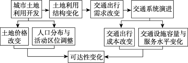
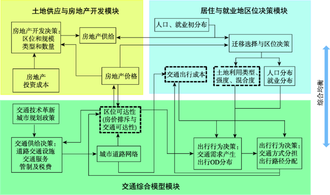
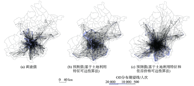
交通与土地利用的协调发展是缓解城市交通拥堵、提升交通水平的关键。城市交通与土地利用一体化模型则是分析和模拟城市交通与土地利用相互作用过程的重要科学支撑。多年来不同国家学者已研发出一些操作模型,并用于城市空间政策的制定研究,但这些模型的核心算法仍需进一步升级完善。本文首先梳理了当前已有主流模型的理论特征,解析了这些模型的核心算法发展及其优缺点;然后针对关键算法的不足,提出新的综合均衡模型,就区位可达性、用地混合度与强度、出行成本3个关键变量的核心算法展开讨论;最后,进一步形成模型各子模块的算法创新,包括考虑增量离散选择过程的居住与就业区位决策模块、细分房地产类型并将土地开发结果动态反馈至城市用地演变的房地产开发模块、采用改进的阻抗函数、小汽车拥有情况和动态出行成本的交通综合模型。本文对于定量化分析模拟城市复杂系统、研发我国城市交通与土地利用一体化模型具有一定的参考价值。

赵鹏军 , 万婕 . 城市交通与土地利用一体化模型的核心算法进展及技术创新[J]. 地球信息科学学报, 2020 , 22(4) : 792 -804 . DOI: 10.12082/dqxxkx.2020.190628
The coordinated development of urban transport and land use is of great practical significance to optimize urban spatial structure, reduce traffic congestion, and improve transport level. The integration of land use and transport systems is important for smart growth and sustainable development of cities. The integrated model of urban transport and land use is a key scientific support to analyze and simulate the interaction between urban transport and land use. Over the years, scholars in different countries have developed operational models that can be used for urban spatial policy formulation. However, the core algorithm of these models still need to be further improved. In this paper, the theoretical characteristics of existing mainstream models were analyzed. Based on the theoretical basis and the core algorithms, the advantages and disadvantages of six models were discussed, including spatial interaction model, urban economics and mathematical planning model, spatial input-output model, discrete choice model, micro-simulation model, and cellular automata model. A new comprehensive equilibrium model was proposed to overcome the shortcomings of the existing models. On the one hand, endogenous variable processing and dynamic feedback of the key algorithms need to be improved. On the other hand, the existing models do not fully consider the impacts of exogenous variables such as technological innovation, urban management, and urban planning policies. Therefore, new thinking was put forward for the core algorithm incorporating three key variables: Accessibility, land use characteristics, and travel cost. The equilibrium model adopts land use intensity and diversity to represent land use characteristics, and uses the improved algorithm of accessibility that takes into account the repulsive force caused by housing price and the opportunity scale of land use characteristics. In the generalized travel cost, attributes at the individual level and characteristics at the urban environment level are considered comprehensively. New algorithms were also proposed for the three modules of the integrated model, which include the residence and employment location decision module that considers incremental discrete selection process, the land supply and real estate development module that subdivides real estate types and dynamically feeds back land development results to urban land use evolution, and the comprehensive transport model that adopts improved impedance function, dynamic travel cost, and car ownership. It has important theoretical value for quantitative simulation of urban spatial evolution, prediction of trip distribution, and evaluation of urban management and planning policies. At the same time, it is of practical significance to develop the integrated model of urban transport and land use in China, so as to optimize the distribution of population and trip demand, and ease urban traffic congestion.
表1 代表性城市土地利用与交通一体化模型总结Tab. 1 Summary of representative integrated models of urban transport and land use |
| 类别 | 模型 | 关键变量和核心算法原则 | 优势 | 缺点 |
|---|---|---|---|---|
| 空间相互作用模型 | TOMM模型[15] | 考虑城市空间相互作用与不同收入组别居民的空间分配 | 形式简单,易于获取数据来定量表达城市土地利用间的相互作用,进行模型校准 | 基于统计学模型,缺乏经济学理论解释,积极模型难以描述个体离散行为选择 |
| 熵最大化模型[16] | 衡量不同区位的可达性和吸引力指标的空间相互作用关系 | |||
| ITLUP模型[17] | 第一个土地、人口就业与交通的集成系统,应用广泛 | |||
| PLUM模型[18] | 基于空间相互作用的城市活动分布模型 | |||
| LILT模型[19] | 基于统计模型的人口、就业、用地预测与交通流分配 | |||
| Simulacra模型[20] | 城市用地的时间动态模拟过程 | |||
| 城市经济学与数学规划模型 | TOPAZ模型[21] | 以最低的出行、公共服务、建筑等基础条件确定城市土地利用模式的 最优方案(出行成本) | 模型目标明确,能有效优化城市用地布局和交通发展方案 | 模型约束条件简单,难以综合衡量土地与交通系统的复杂作用过程 |
| Oppenheim模型[22] | 综合区位选址成本和交通出行成本之和的最小化目标函数(出行成本) | |||
| MUSSA模型[23] | 地租理论框架下的土地和住房市场,形成不同类别家庭的住房区位决策与交通出行选择 | |||
| PECAS模型[24] | 利用区域经济学模型对地块层面土地开发的微观模拟 | |||
| 空间投入产出模型 | MEPLAN模型[25] | 考虑空间投入产出关系产生的交通出行作为经济互动的派生需求(生产与消费、交通成本) | 从经济学理论考虑空间投入产出关系,从而模拟城市土地利用变化 | 考虑集聚行为,无法描述个体行为与决策过程 |
| TRANUS模型[26] | 基于人、物流动的城市活动空间分布于相互作用,形成交通出行产生与路径选择的复杂联合模型(广义出行成本) | |||
| DELTA模型[27] | 考虑城市人口结构与社会经济属性转变的模拟(出行可达性) | |||
| 随机效用选择模型 | METROSIM模型[28] | 在离散、非平稳的房地产市场动态均衡中的投资者和消费者的概率离散选择 | 考虑微观个体理性人假定的决策过程 | 对于输入数据的要求较高 |
| 微观仿真模型 | Urbansim模型[5] | 地块层面考虑人口转变和土地利用的综合模型(用地结构、出行成本) | 能够有效描述城市土地利用与交通系统中决策个体的微观行为 | 输入数据的要求较高,处理难度较大 |
| ILUTE模型[29] | 包括土地利用、区位选择、汽车拥有权、基于活动的出行模型的城市系统 | |||
| Ramblas模型[30] | 微观人口模拟(用地结构) | |||
| MASTER模型[31] | 以家庭为分析单元,考虑城市人口数量增长与结构转变 | |||
| IRPUD模型[32] | 模拟城市活动区位选择和迁移决策(经济、人口、用地结构) | |||
| ILUMASS模型[33] | 集成微观模型和环境评估的扩展模型(用地结构、人口流动性) | |||
| 元胞自动机和多智能体模型 | SLEUTH模型[34] | 使用预先定义增长规则在空间上嵌套循环的城市用地网格的元胞自动机模型 | 更加精确地描述城市复杂系统中的土地利用演变过程 | 仍需提升综合考虑人口、社会经济、政策环境对系统的影响 |
| DEUM模型[35] | 模拟城市土地利用演变过程 | |||
| CLUE-S模型[36] | 基于系统论综合分析城市土地利用变化与社会经济、物理等驱动过程 |
表2 既有城市交通与土地利用一体化模型与综合均衡模型中的可达性算法方法Tab. 2 Accessibility measurement methods of existing integrated models and the comprehensive equilibrium model |
| 模型 | 可达性测度公式 | 公式编号 | 变量与参数说明 | |
|---|---|---|---|---|
| 已有模型的 可达性计算 | LILT模型 | (11) | 为区域i内的居住人口数量;为区域i和j之间的距离 | |
| MUSSA模型 | (12) | 为经济活动产生的效用;为参数 | ||
| BLUTI模型 | (13) | 为区域j内的就业人口数量;为第k类交通方式的出行成本;Per为此类交通方式的出行比例 | ||
| IRPUD模型 | (14) | 为区域i和j之间的出行成本;为参数;为土地价格对经济活动的吸引力 | ||
| 综合均衡模型内 的可达性算法 | (15) | 为v类型用地的出行吸引率;为区域j内v类型用地的建筑面积;为t时段区域i内的住房价格;为t时段城市住房平均价格水平;为区域i和j之间的距离;γ为参数 |
| [1] |
|
| [2] |
|
| [3] |
|
| [4] |
|
| [5] |
|
| [6] |
金相郁 . 20世纪区位理论的五个发展阶段及其评述[J]. 经济地理, 2004,24(3):294-298,317.
[
|
| [7] |
|
| [8] |
|
| [9] |
|
| [10] |
|
| [11] |
|
| [12] |
|
| [13] |
|
| [14] |
|
| [15] |
|
| [16] |
|
| [17] |
|
| [18] |
|
| [19] |
|
| [20] |
|
| [21] |
|
| [22] |
|
| [23] |
|
| [24] |
|
| [25] |
|
| [26] |
|
| [27] |
|
| [28] |
|
| [29] |
|
| [30] |
|
| [31] |
|
| [32] |
|
| [33] |
|
| [34] |
|
| [35] |
|
| [36] |
|
| [37] |
|
| [38] |
|
| [39] |
|
| [40] |
|
| [41] |
|
| [42] |
|
| [43] |
|
| [44] |
|
| [45] |
|
| [46] |
|
| [47] |
|
| [48] |
|
| [49] |
吴健生, 李博, 黄秀兰 . 小城市居民出行行为时空动态及驱动机制研究[J]. 地球信息科学学报, 2017,19(2):176-184.
[
|
| [50] |
曹劲舟, 涂伟, 李清泉 , 等. 基于大规模手机定位数据的群体活动时空特征分析[J]. 地球信息科学学报, 2017,19(4):467-474.
[
|
| [51] |
|
| [52] |
|
| [53] |
|
| [54] |
|
| [55] |
陈彦光, 刘明华 . 城市土地利用结构的熵值定律[J]. 人文地理, 2001,16(4):25-29.
[
|
| [56] |
|
| [57] |
|
| [58] |
|
| [59] |
|
| [60] |
|
| [61] |
|
| [62] |
|
| [63] |
|
| [64] |
|
| [65] |
|
| [66] |
|
| [67] |
|
| [68] |
|
| [69] |
|
| [70] |
|
| [71] |
|
| [72] |
|
| [73] |
|
| [74] |
尹上岗, 李在军, 宋伟轩 , 等. 基于地理探测器的南京市住宅租金空间分异格局及驱动因素研究[J]. 地球信息科学学报, 2018(8):1139-1149.
[
|
| [75] |
|
| [76] |
|
| [77] |
|
| [78] |
|
| [79] |
|
| [80] |
|
| [81] |
|
/
| 〈 |
|
〉 |