黄土高原沟谷地貌发育演化研究进展与展望

  • 熊礼阳 1, 2, 3 ,
  • 汤国安 , 1, 2, 3, *
展开
  • 1. 虚拟地理环境教育部重点实验室(南京师范大学),南京 210023
  • 2. 南京师范大学地理科学学院,南京 210023
  • 3. 江苏省地理信息资源开发与利用协同创新中心,南京 210023
* 汤国安(1961— ),男,浙江宁波人,博士,教授,主要从事GIS数字地形分析研究。E-mail:

熊礼阳(1989— ),男,江西南昌人,博士,副教授,主要从事黄土地貌演化与数字地形分析研究。E-mail:xiongliyang@njnu.edu.cn

收稿日期: 2019-09-13

  要求修回日期: 2019-11-17

  网络出版日期: 2020-06-10

基金资助

国家自然科学基金项目(41930102)

国家自然科学基金项目(41971333)

江苏高校优势学科建设工程资助项目()

版权

版权所有,未经授权,不得转载、摘编本刊文章,不得使用本刊的版式设计。

Research Progresses and Prospects of Gully Landform Formation and Evolution in the Loess Plateau of China

  • XIONG Liyang 1, 2, 3 ,
  • TANG Guoan , 1, 2, 3, *
Expand
  • 1. Key Laboratory of Virtual Geographic Environment, Ministry of Education, Nanjing Normal University, Nanjing 210023, China
  • 2. School of Geography, Nanjing Normal University, Nanjing 210023, China
  • 3. Jiangsu Center for Collaborative Innovation in Geographical Information Resource Development and Application, Nanjing 210023, China
* TANG Guoan, E-mail:

Received date: 2019-09-13

  Request revised date: 2019-11-17

  Online published: 2020-06-10

Supported by

National Natural Science Foundation of China(41930102)

National Natural Science Foundation of China(41971333)

Priority Academic Program Development of Jiangsu Higher Education Institutions()

Copyright

Copyright reserved © 2016

摘要

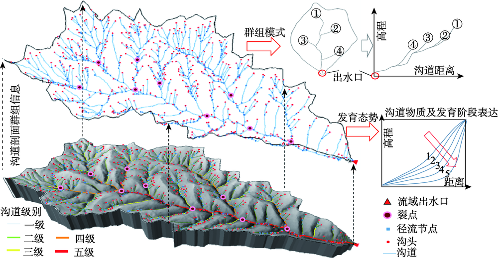
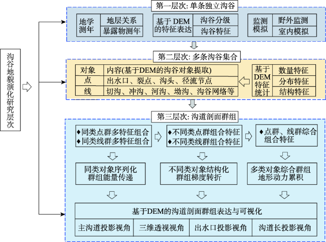
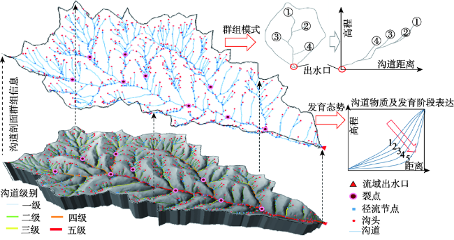
黄土沟谷是黄土地貌中最有活力、最具变化、最富特色的对象单元,黄土高原千沟万壑的地貌形态以及触目惊心的侵蚀状态也让区域内沟谷地貌的形成、发育及演化问题成为研究中焦点及前沿性科学问题。近年来,诸多学者采用地学测年法、特征表达法、监测模拟法力图实现对黄土沟谷发育演化进程中“过去-现代-未来”的科学认知。这些研究在相当程度上丰富了黄土沟谷发育过程的认知。本文梳理了黄土高原沟谷地貌演化相关研究的现状,并从黄土高原地貌演化、黄土沟谷发育、基于DEM的沟谷信息提取与表达等研究进行了系统的回顾、梳理与分析。此外,本文提出“黄土沟道剖面群组”概念与方法,试图从新的视角审视黄土沟谷地貌发育演化过程。沟道剖面在黄土沟谷发育演化进程中传递物质能量和累积地形动力,并通过径流节点的串联实现剖面群的连接与组合,形成独特的剖面“群组”模式;该沟道剖面群组是集黄土沟谷地貌特征与过程于一体的综合信息集成体,其三维空间结构是对黄土沟谷地貌发育演化的高度抽象与映射,并可望进一步丰富黄土高原数字地形分析理论与方法体系,为黄土高原黄土地貌成因机理与空间分异格局带来创新的认识。

本文引用格式

熊礼阳 , 汤国安 . 黄土高原沟谷地貌发育演化研究进展与展望[J]. 地球信息科学学报, 2020 , 22(4) : 816 -826 . DOI: 10.12082/dqxxkx.2020.190519

Abstract

Loess gully should be the most dynamic and changeable landform unit among the loess landforms in the Loess Plateau of China. In this plateau, the surface morphology presents thousands of gullies with a severe soil erosion pattern. This specific environment makes the area to a research focus both in the studies of geomorphology and soil erosion, especially the frontier questions of the formation and evolution of the gully landform. In the recent years, methods of geochronological dating, geomorphological feature expression, and monitoring simulation have been used by many scholars for better understanding of loess gully formation from the perspective of "past", "now", and "future". These advances have enriched our knowledge of loess gully formation and evolutionary processes. In this research, we systematically analyzed the research status quo and progresses of related studies on loess gully evolution in the Loess Plateau. These related studies include the landform evolution in the Loess Plateau, the loess gully formation, and the gully information extraction and expression using the DEM data. We argued that existing studies of loess gully formation and evolution should be further improved, with especially the help of theories and methods of the modern geographical information science. To this end, we proposed the concept of loess gully profile combination, trying to understand loess gully formation and evolutionary processes from a new perspective. The profile of gully transfers matter energy and accumulates terrain power during loess gully evolution. In addition, with the connection of runoff nodes, different gully profiles are connected and combined with each other, forming a specific pattern of gully profile combination. This combination should be a comprehensive information integration which integrates features and processes of loess gully landform. The three-dimensional spatial structure of the gully profile combination is an abstraction and mapping of loess gully landform evolution. The quantitative expression model of gully profile combination is expected to build, which should be oriented to loess gully landform evolution. This gully profile combination will help to achieve a new understanding of the loess gully formation mechanism during loess gully evolutionary processes, and to refine the gully evolution rules and patterns in the Loess Plateau. The gully profile combination is expected to further enrich digital terrain analysis methods.

1 引言

黄土高原千沟万壑的地貌形态、纵横交错的沟谷网络、形态迥异的沟谷景观,是经过黄土堆积、侵蚀和搬运,在风力和水力的交互作用下,并承袭下伏古地貌基础之上发育形成的[1,2,3,4]。黄土沟谷是黄土地貌中最有活力、最具变化、最富特色的对象单元,也是黄土地貌研究的重要关注点。黄土沟谷的发育演化研究对于揭示物质、能量、时间在塑造沟谷形态中的作用,发掘黄土沟谷的形成与土壤侵蚀的内在机理,指导黄土高原生态修复与区域可持续发展,都具有重要的理论意义与广阔的应用前景。
自20世纪以来,黄土高原黄土地貌形成机理与演化规律研究一直是地学研究的热点。黄土沟谷,作为黄土地貌研究的重要组成部分,众多地理学家从不同的角度对其发育模式与演化规律进行了深入探索。其研究方法主要可分为:① 地学测年法,即从地质历史的角度,依据黄土沟谷发育后覆盖的黄土-古土壤序列地层关系或黄土沟谷中残留物暴露时间等方式进行测年,进而重建不同历史时期的黄土沟谷地貌形态[5,6,7,8,9];② 特征表达法,即对黄土沟谷进行纹沟、细沟、浅沟、切沟、冲沟、河沟等不同级别的类型划分,并计算不同类型沟谷区域的地形特征,如面积高程积分、汇流等级关系、沟谷横纵断面比、沟谷分支比等,基于“空代时”的思路,以沟谷类型映射沟谷发育过程,形成沟谷地貌发育的“时—空”演变特征序列[10,11,12,13,14,15,16];③ 监测模拟法,基于摄影测量、RS、GIS技术,对野外黄土沟谷或室内人工模拟沟谷进行发育过程的动态监测,在此基础上,充分考虑黄土沟谷地貌形成的各种环境变量,建立沟谷地貌演化模型,用以对黄土沟谷的演化模拟[17,18,19,20,21]。这3种方法力图实现对黄土沟谷发育演化进程中“过去—现代—未来”的科学认知。
然而,第① 种方法依赖于准确并且合理的年代数据,但与黄土堆积过程不同,沟谷演变过程在相当程度上是一个消失的年轮,即便年代测量准确也往往难以表征当时沟谷地貌形态;第② 种方法目前往往局限于研究所选择的样区,且大多数区域的沟谷类型序列是存在缺失的,所对应沟谷时空特征序列在相当程度上是不完整的;第③ 种方法仅能在较小的时空尺度展开,也难以获取历史时期的沟谷地貌形态。上述问题在一定程度上制约了对黄土沟谷演化机理及黄土沟谷地貌形成认识的深入,迫切需要引入新的思路来阐述黄土沟谷发育演化过程,亟待借助现代地理信息科学的理论与方法,以兼顾“共性与个性”、耦合“宏观与微观”、表达“静态与动态”的研究脉络,从“形”、“数”、“理”的研究视角,实现对黄土沟谷发育演化过程的地貌科学认知。
从沟道剖面来看,黄土沟道剖面蕴含着丰富且重要的黄土沟谷地貌发育演化信息。它是黄土沟谷演化过程中的物质能量传递线、梯度变化转折线、地形动力累积线。这些黄土沟道剖面以“群态”的形式存在,并在径流节点的串联下在空间中形成不同的“组合”。基于此,本文首先系统分析了黄土高原沟谷地貌发育演化研究的现状;在此基础上,将现有黄土沟谷地貌发育演化研究存在问题与沟道剖面的“群态”与“组合”特征相结合,并提出“黄土沟道剖面群组”概念,试图从新的视角展望黄土高原沟谷地貌发育演化研究。

2 研究现状与分析

针对黄土高原沟谷地貌发育演化问题,本文从黄土高原地貌演化、黄土沟谷发育、沟谷及沟道剖面信息提取与表达3个方面对国内外相关研究成果进行总结与分析。

2.1 黄土高原地貌演化研究

中国黄土高原所发育的黄土地貌,以其巨厚的黄土堆积、富于变化的黄土地貌类型而闻名于世[1]。第四纪以来,在青藏高原快速抬升和东亚季风气候环境的背景影响下,来自中亚干旱沙漠区域的黄土粉尘逐步降尘并堆积在现今黄土高原内[22]。经过200余万年黄土堆积、侵蚀和搬运,在风力和水力交互作用下,在承袭下伏古地貌基础之上,现代黄土高原黄土塬、梁、峁及沟谷等地貌逐渐形成。
自20世纪以来,国内外学者从地貌发育循环理论、黄土物源成因、黄土下伏古地貌等角度对黄土高原地貌演化研究进行了长期探索,取得了丰富的研究成果。在地貌发育循环理论上,早在1907年,Willis等[23,24]将戴维斯地貌发育循环理论应用到黄土地貌演化研究中。此后,Strahler[13]提出面积高程积分指标,用于定量化表达戴维斯理论,即地貌发育分别量化为幼年期、壮年期和老年期3个阶段,该地貌发育阶段量化方法广泛应用于后续黄土地貌发育研究中[25,26,27,28],如励强等[27]采用临界侵蚀积分值来定量划分黄土地貌的流域发育阶段。在黄土物源成因上,诸多学者通过黄土物源及其堆积速率、原生黄土堆积与次生黄土搬运再堆积、黄土地层序列来揭示黄土地貌形成的动力机制[29,30,31,32],如原生与次生黄土丘陵地貌演变模式[30]、黄土沉积物分布与古土壤层交错的特征来揭示古环境与地貌变化[32]。在黄土下伏古地貌上,中国学者早期展开了黄土下伏古地形对现今黄土地貌发育控制作用的大量描述性研究[1,4-6,33-37]。例如,刘东生等[1]认为现代黄土高原的地貌形态带有很大的继承性,继承了第四纪以前复杂多样的格式;诸多学者对洛川塬区、黄土梁区和黄土峁区的古地形都做了相应的分析研究[4,30,37]
近年来,随着现代遥感对地观测技术与地理信息科学的发展,多源、跨学科的地学信息有机结合与相互渗透,给传统的地学分析方法带来了革命性的变化[38,39],也为黄土高原地貌演化研究带来了崭新的思路。目前开展的相关研究包括:基于野外航测数据对黄土地貌的发育过程进行监测与建模,进而展开相应的地貌演化机理分析[40,41,42];利用GIS和近景摄影测量方法对室内人工降雨模拟小流域进行发育过程的动态监测与分析研究[19];借助元胞自动机、复杂网络、图论等理论与方法对黄土地貌的正负地形、坡面及水系演化过程进行了研究[17-18,43-45];通过对多源地学数据的重新组织,以及GIS数字地形分析方法的应用与拓展,在黄土下伏古地形建模、双层地形下黄土地貌发育、黄土地貌演化继承性等研究已经取得了部分研究成果[46,47,48,49,50,51,52,53]。上述研究表明了地理信息科学理论与方法在黄土高原地貌发育演化研究中广阔的应用前景。

2.2 黄土沟谷地貌发育研究

黄土高原以典型多样的黄土塬、梁、峁等正地形单元存在并闻名的同时,也因千沟万壑的黄土沟谷负地形单元而让该区域触目惊心。因此,黄土沟谷发育过程成为黄土地貌演化研究的另一代表性过程。目前黄土沟谷发育研究主要从侵蚀学和地貌学2个不同的角度展开。
(1)在侵蚀学角度相关研究中,诸多学者展开了面向宏观的黄土沟谷侵蚀分区以及面向微观的沟谷侵蚀过程研究。宏观上,主要通过对区域沟谷地貌特征与气候、植被、土壤等自然要素的复合分析,以揭示区域沟谷侵蚀的主要驱动力及其类型,最终明确不同黄土地貌类型区黄土沟谷侵蚀方式[11,54-56];微观上,在沟谷侵蚀特征[6]、沟谷侵蚀速 率[57]、侵蚀产沙模型[58]、沟谷侵蚀临界[59]、沟谷强烈侵蚀期[60]、侵蚀堆积模式[5]、坡沟侵蚀关系[61]等方面吸引了众多学者的关注,取得了突出研究成果。
(2)在地貌学角度的黄土沟谷发育研究中,科学的沟谷地貌认知及其分类体系是探讨黄土沟谷发育过程的重要基础。据此,众多学者从沟谷形态[2]、径流冲刷[11]、地貌发育[62,63]等不同角度对黄土沟谷进行认知与分类,并形成细沟、浅沟、切沟、冲沟、坳沟(干沟)及河沟等类型的黄土沟谷分类体系。在黄土沟谷发育研究中,罗来兴[11]研究表明黄土沟谷发育的模式主要为沟谷的下切作用以及沟坡的扩展和沟头前进过程;陈传康[64]从形态上分阶段阐述了黄土沟谷的发育过程;桑广书等[65]依据晚中更新世以来洛河阶地和古地貌形态,分析了洛川黑木沟的发育过程;严宝文等[66]以黄土高原的典型沟谷为例,研究了不同地貌类型的沟谷发育阶段;何雨等[67]采用沟谷宽深比指标来揭示黄土沟谷发育阶段的稳定性。总体来看,学者们已经在沟谷的发育模式、发育过程、发育阶段、发育年代和发育的地貌特征等方面取得了富有成效的成果[64,65,66,67,68],在一定程度上深化了对黄土沟谷发育及其规律的认识。
但是,黄土沟谷的发育是由不同沟头向流域出水口历经沟道剖面中裂点群的溯源侵蚀、径流节点群的能量串联、沟道群的物质传输而形成的不同层次、结构、组合下的沟道剖面群组式的地貌演化过程。因此,黄土沟谷地貌发育演化研究必须也必然基于沟道剖面群组视角加以探讨,以期对其进行全面、系统、深刻的分析。

2.3 基于DEM的沟谷信息提取与表达研究

近年来,数字高程模型(DEM)与数字地形分析(DTA)的提出与应用,极大地促进了现代地貌学研究的发展[38,39]。在DEM与DTA的支持下,地貌形态中的特征地形要素能够自动提取、分析、与过程建模[69,70]。目前,相关研究已形成了对不同特征地形要素提取与表达的方法体系,成为揭示地貌形态组合特征与演化规律的重要依据。
沟谷是一个在空间上广泛展布,在时间上不断发育的自然综合体,有着其自身特有的形成发展规律。沟道也是沟谷中由沟底、沟头、裂点、径流节点与流域出水口等个体和群体组成的沟谷系统。目前已开展的研究主要包括:① 针对沟谷地形特征要素提出沟道剖面中的径流节点[71]、沟头[72]、沟谷裂点[73]等相应提取方法,如罗明良[74]提出了地形特征点簇的概念模型及其提取与分析方法,初步实现了将不同地形特征点要素的一体化表达;② 沟谷网络作为典型地形特征线状要素,其提取方法与分析也受到了大量关注[75,76,77,78,79,80,81,82,83]。在沟道信息表达上,众多学者基于沟谷密度、河网分维、分枝比、沟谷信息熵等指标对沟谷形态进行了相关研究[84,85,86,87,88,89,90,91],分别从不同视角探索沟谷特征,取得了较好的成果,体现出DEM在沟谷地貌研究中巨大的潜力;③ 主沟道剖面形态、沟谷横断面量化、横—纵剖面耦合演化等沟道的信息表达与过程揭示也吸引了诸多学者的探讨[92,93,94,95];④ 从汇流关系角度对沟谷的层级结构进行分级,出现了Strahler分级[96]、Horton分级[97]、Shreve分级[98]等多种分级方法,这些方法目前已广泛应用于水文分析中。以上关于沟谷研究的系列成果,均对黄土沟谷研究提供了可以借鉴的思路和方法。
但是,应该注意到,在三维空间中,不同沟道剖面地形特征在黄土沟谷地貌演化进程中是紧密联系在一起的,侵蚀基准的降低改变了沟谷发育的势能,裂点的后退使得沟道剖面寻求新的平衡,径流节点的串联使得不同沟谷能量实现汇集。这些具有地貌学含义的地形空间关系迫切需要对沟道剖面群组进行全新的思考,需要从现代地理信息科学的全新视角,认真解读黄土沟道剖面群组的科学内涵与表达方法,有效揭示黄土沟谷地貌演化的过程与机理,并在GIS数字地形分析中传承与实现。

3 基于DEM的黄土沟谷地貌演化 研究展望

3.1 基于DEM的沟道剖面研究及其对黄土沟谷 地貌发育的意义

黄土沟谷的发育特征为:沟头的溯源侵蚀使得地表被进一步切割,沟谷向前进一步延伸;侵蚀基准的降低造成沟谷侵蚀势能增加,沟谷发生下切作用,沟道中裂点后移,并进一步加剧溯源侵蚀;沟谷的侧蚀映射着沟谷横断面的变化,或沟道加宽,或沟谷“V”、“U”等形态的转变;沟谷的稳定表明当前沟谷发育驱动作用力较弱,沟谷发育形成相对稳定的均衡剖面。可以看出,黄土沟谷发育具有独特的地学过程,并塑造了典型的黄土沟谷形态。长期以来,在DEM数据的支撑下,学者们基于长度、宽度、密度、分支比、网络结构(如树枝状结构)等不同指标对沟谷的形态特征、空间格局、分布规律进行了深入的研究[85,86,87,88,89,90,91]。这些研究初步使得沟谷地貌演化研究从单条独立沟谷(第一层次)走向多条沟谷集合式(第二层次)的研究拓展(图1)。但是,当前研究主要考虑沟谷对象在水平方向上的特征和分异规律,而沟谷形态在相当程度上是由纵向、横向和垂向的驱动力在时间上形成的四维空间产物[99],该四维空间过程表现在沟谷水平面特征的同时,更映射在沟谷的剖面信息上。从剖面来看,在沟谷横断面量化、主沟道剖面形态、横-纵剖面耦合演化特征等方面进行了初步探索[92,93,94,95]。这些研究都证实了纵剖面和横断面线在地貌演化研究中的作用。然而,沟谷横断面存在各向异性,横断面位置的选择更具有一定的随机性与偶然性。而沟谷纵剖面,现有研究较多的关注主沟道剖面的个体特征,相对忽视沟道剖面的群体特征。但是,流域内的沟谷地貌发育过程是不同沟谷在水平面和剖面一体的三维空间下相互作用、因果共生、空间依存、紧密联系的有机整体,表现出其特有的形态特征、组成结构及空间格局。特别是在沟道剖面上,它蕴含着更为丰富且重要的黄土沟谷地貌发育演化信息。
图1 沟谷地貌演化研究不同层次

Fig. 1 Different levels of gully landform evolution studies

沟道剖面的黄土沟谷地貌发育演化表现为:
(1)它是物质能量传递线。黄土坡面上的物质和能量,自坡面起,历经沟道剖面中的沟头,切沟、冲沟、坳沟、河沟等沟道自上而下式的向流域出水口传递;这种传递过程塑造了黄土沟谷物质的搬运与再堆积,以及能量的转换与再平衡。
(2)它是梯度变化转折线。黄土沟道剖面出水口位置可下切至基岩,成为临时侵蚀基准;侵蚀基准点与沟头之间发育着大量的沟谷裂点;侵蚀基准点、沟谷裂点、沟头及沟道的有机组合代表着不同梯度均衡剖面在沟谷发育时的变化与转折。
(3)它是地形动力累积线。沟道剖面中,黄土物质和能量从沟头向流域出水口传输的同时,地形动力也相应的出现自上而下“滚雪球”式的累积;这种累积式动力造就了黄土沟道剖面线中发育的不同类型沟谷,对应着不同沟道级别和不同沟道属性。据此,当前沟谷地貌演化研究亟待走向第三层次的沟谷剖面研究(图1)。

3.2 黄土沟道剖面群组的提出及对黄土沟谷地貌 发育的研究展望

在沟道剖面研究中更为重要的是,流域由若干条沟谷组成,且各沟谷的发育不是彼此独立存在的,也并不意味着主沟道的发育发挥着决定性作用。准确地说,它是一个沟谷群,对应着沟道剖面群。各沟道剖面的物质能量、梯度变化、地形动力通过径流节点的串联实现沟谷间的有机连接,形成独特的沟道剖面“群态”。这种“群态”随着层次的不同、结构的不同、模式的不同而形成不同的空间“组合”特征,也就是“黄土沟道剖面群组”(图2)。
图2 黄土沟道剖面群组构建与分析示意

注:群组模式包括沟道距离视角、主沟道视角、外包正四面体视角、出水口视角等。

Fig. 2 Construction and analysis of an example loess gully profile combination

研究表明,该剖面群组在黄土沟谷地貌演化过程中表现为:① 地形特征的有机组合,黄土沟道剖面群组包含流域出水口、裂点、径流节点、沟头等地形特征群,这些特征在沟道剖面中形成看似无序实则有序的高程递进式空间组合关系;② 沟谷网络的动态连接,黄土沟道剖面群组既存在浅沟、切沟、冲沟、坳沟等不同等级沟谷的有机连接,也包含相同等级沟谷汇集并可发生等级变化的沟谷发育动态连接;③ 地貌演化的驱动映射,黄土沟道剖面群组是由流域内各沟道剖面组合形成的完整地貌发育均衡剖面,映射着沟谷发育溯源侵蚀和沟道传输等能量交换的自组织式地貌演化过程。
黄土沟道剖面群组是集沟谷地貌特征与过程于一体的综合信息集成体,它的三维空间结构是对黄土沟谷地貌发育演化的高度抽象与映射。在研究中,只有从剖面群组的视角审视黄土沟谷演化过程,才能科学把握黄土沟谷地貌演化的垂向动力机制、准确刻画黄土沟谷地貌局部与整体的发育程度、有效度量兼顾黄土沟谷个体与群体的发育速度,以及完整揭示黄土沟谷地貌发育的区域差异性。在实际应用中,沟道治理也是黄土高原小流域综合治理的核心与关键所在。全国水土保持普查中将侵蚀沟道的空间分布、发展阶段及其发展趋势的调查作为重要的普查内容。2013年公布的全国水利普查公报结果显示,黄土高原仅侵蚀沟道就共计有666 719条。这个数据对于了解黄土高原沟谷发育的总体态势是有利的,但是由于未能掌握揭示黄土沟道发育过程与机理核心指标,之前所指定的揭示黄土沟谷发展阶段及其发展趋势的目的,尚未能有效实现。
沟道剖面群组分析法将是黄土沟谷地貌特征结构表达及其形成机理研究的有效切入点,也是黄土沟谷地貌发育状态、演化趋势研究的绝好抓手;而黄土高原重点水土流失区稳定的地质条件以及黄土物质的均一性,则成为沟道剖面群组研究黄土沟谷地貌演化绝好的实验条件。但是,在黄土沟谷发育过程中,目前尚没有科学认知沟道剖面呈现的群态与组合信息,也没有完全解读该黄土沟道剖面群组的层次特征与结构特征,更没有有效揭示沟道剖面群组是如何动态演化的。沟道剖面群组认知给我们一个重要的启示,即在黄土沟谷地貌演化研究中,基于侧面的沟道剖面视角,运用GIS数字地形分析方法,发掘黄土沟谷演化过程中不同区域沟道剖面的群态特征与组合结构,解读黄土沟道剖面群组在不同尺度与空间的相似性与差异性,形成其科学分类体系。在此基础上,探究沟道剖面群组视角下黄土沟谷演化过程的宏观与微观、整体与局部以及表象与机理之间的联系,厘清其“形、数、理”的内在关系。最终,研究可揭示黄土沟谷地貌演化外在表象与内在机理的科学问题,实现对黄土沟谷地貌形态及其演化特征的深入、系统且新颖、全面的知识发现,丰富黄土高原数字地形分析理论与方法体系,为黄土高原黄土地貌成因机理与空间分异格局带来创新性认识。

4 结论与讨论

经过长期的探索与实践,黄土高原沟谷地貌的形成机理与演化规律研究已成为地学研究的热点之一。本研究已初步形成了地学测年法、特征表达法和监测模拟法等不同视角对黄土沟谷发育演化的研究,力图实现对其发育演化进程中“过去—现代—未来”的科学认知。但是,亟待需借助现代地理信息科学的理论与方法,深入探讨黄土沟谷演化机理及黄土沟谷地貌形成规律,实现对黄土沟谷发育演化过程的地貌科学认知。
DEM与DTA的提出与应用,极大地促进了黄土沟谷地貌研究的发展。基于DEM数据和DTA方法的黄土沟谷信息自动提取、定量表达及过程模拟,将为进一步揭示黄土沟谷地貌的形态起伏、成因机理、分布格局及其演变规律等地貌学本源问题提供重要依据,以兼顾“共性与个性”、耦合“宏观与微观”、表达“静态与动态”的研究脉络,从“形”、“数”、“理”的研究视角,重新审视黄土沟谷发育演化过程。
黄土沟谷地貌发育演化研究中,沟道剖面群组分析法的提出与探索必然形成黄土沟谷发育模式、演化机理和分异格局的新认知。在此过程中,已初步了解到黄土沟谷地貌演化过程是以黄土沟道作为物质与能量传输的廊道,在剖面上形成的从沟头到裂点再到流域出水口的重力作用过程;逐步认识到黄土沟谷发育进程中,沟谷间不是彼此独立的,是以径流节点的串联实现了信息的交换,形成沟谷发育时特定的沟道剖面群组模式;意识到三维情景下黄土沟谷地貌演化研究中,当代地理信息科学的三维空间认知与建模应置身并融入其中,形成沟谷地貌研究新的认知发现。
[1]
刘东生 . 黄土与环境[M] 北京: 科学出版社, 1985.

[ Liu D S . Loess and Environment[M]. Beijing: Science Press, 1985. ]

[2]
陈永宗, 景可, 蔡强国 . 黄土高原现代侵蚀与治理[M]. 北京: 科学出版社, 1988.

[ Chen Y Z, Jing K, Cai G Q . Modern erosion and management of the Loess Plateau[M]. Beijing: Science Press, 1988. ]

[3]
张宗祜 . 我国黄土高原区域地质地貌特征及现代侵蚀作用[J]. 地质学报, 1981(4):308-320,326.

[ Zhang Z H . Regional geological and morphological characteristics and development of soil erosion in the Loess Plateau, China[J]. Acta Geologica Sinica, 1981(4):308-302,326. ]

[4]
甘枝茂 . 黄土高原地貌与土壤侵蚀研究[M]. 西安: 陕西人民出版社, 1990.

[ Gan Z M . Study on landform and soil erosion in the Loess Plateau[M]. Xi'an: Shaanxi People's Press, 1990. ]

[5]
邓成龙, 袁宝印 . 末次间冰期以来黄河中游黄土高原沟谷侵蚀-堆积过程初探[J]. 地理学报, 2001,56(1):92-98.

[ Deng C L, Yuan B Y . Processes of gully erosion and accumulation in the central Loess Plateau of China since the last interglacial[J]. Acta Geographica Sinica, 2001,56(1):92-98. ]

[6]
袁宝印, 巴特尔, 崔久旭 , 等. 黄土区沟谷发育与气候变化的关系——以洛川黄土塬区为例[J]. 地理学报, 1987,42(4):328-337.

[ Yuan B Y, Ba T E, Cui J X , et al. The relationship between gully development and climatic changes in the loess yuan region: Examples from Luochuan, Shaanxi province[J]. Acta Geographica Sinica, 1987,42(4):328-337. ]

[7]
Pan B, Hu Z, Wang J , et al. A magnetostratigraphic record of landscape development in the eastern Ordos Plateau, China: Transition from Late Miocene and Early Pliocene stacked sedimentation to Late Pliocene and Quaternary uplift and incision by the Yellow River[J]. Geo-morphology, 2011,125(1):225-238.

[8]
Zhang F, Zhang B, Yang M . Beryllium-7 atmospheric deposition and soil inventory on the northern Loess Plateau of China[J]. Atmospheric Environment, 2013,77:178-184.

[9]
Stevens T, Carter A, Watson T P , et al. Genetic linkage between the Yellow River, the Mu Us desert and the Chinese Loess Plateau[J]. Quaternary Science Reviews, 2013,78:355-368.

[10]
黄骁力, 丁浒, 那嘉明 , 等. 地貌发育演化研究的空代时理论与方法[J]. 地理学报, 2017,72(1):94-104.

[ Huang X L, Ding H, Na J M , et al. Theories and methods of space-for-time substitution in geomorphology[J]. Acta Geographica Sinica, 2017,72(1):94-104. ]

[11]
罗来兴 . 划分晋西、陕北、陇东黄土区域沟间地与沟谷的地貌类型[J]. 地理学报, 1956,22(3):201-222.

[ Luo L X . A tentative classification of landforms in the Loess Plateau[J]. Acta Geographica Sinica, 1956,22(3):201-222. ]

[12]
祝士杰, 汤国安, 李发源 , 等. 基于DEM的黄土高原面积高程积分研究[J]. 地理学报, 2013,68(7):921-932.

[ Zhu S J, Tang G A, Li F Y , et al. Spatial variation of hypsometric integral in the Loess Plateau based on DEM[J]. Acta Geographica Sinica, 2013,68(7):921-932. ]

[13]
Strahler A N . Hypsometric (area-altitude) analysis of erosional topography[J]. Bulletin of the Geological Society of America, 1952,63(11):1117-1142.

[14]
艾南山 . 侵蚀流域系统的信息熵[J]. 水土保持学报, 1987,1(2):1-8.

[ Ai N S . Comentropy in erosional drainage-system[J]. Journal of Soil and Water Conservation, 1987,1(2):1-8. ]

[15]
Rinaldo A, Rodriguez-Iturbe I, Rigon R , et al. Minimum energy and fractal structures of drainage networks[J]. Water Resources Research, 1992,28(9):2183-2195.

[16]
Schumm S A, Lichty R W . Time, space, and causality in geomorphology[J]. American Journal of Science, 1965,263(2):110-119.

[17]
原立峰, 常春平, 张青峰 . 基于元胞自动机的小流域侵蚀产沙模型研究[J]. 水土保持通报, 2008,28(2):85-89.

[ Yuan L F, Chang C P, Zhang Q F . Soil erosion and sediment yield model in a small watershed based on Cellular Automata[J]. Bulletin of Soil and Water Conservation, 2008,28(2):85-89. ]

[18]
Cao M, Tang G A, Zhang F, Yang J Y . A cellular automata model for simulating the evolution of positive-negative terrains in a small loess watershed[J]. International Journal of Geographical Information Science, 2013,27(7):1349-1363.

[19]
崔灵周, 李占斌, 朱永清 , 等. 流域侵蚀强度空间分异及动态变化模拟研究[J]. 农业工程学报, 2006,22(12):17-22.

[ Cui L Z, Li Z F, Zhu Y Q , et al. Simulation of spatial differentiation and dynamic variation of watershed erosion intensity[J]. Transactions of the CSAE, 2006,22(12):17-22. ]

[20]
张鹏, 郑粉莉, 陈吉强 , 等. 利用高精度GPS动态监测沟蚀发育过程[J]. 热带地理, 2009,29(4):369-373.

[ Zhang P, Zheng F L, Chen J Q , et al. Application of high-precision GPS to dynamic monitoring gully erosion processes[J]. Tropical Geography, 2009,29(4):369-373. ]

[21]
Wu HY, Xu XM, Zheng FL , et al. Gully morphological characteristics in the loess hilly-gully region based on 3D laser scanning technique[J]. Earth Surface Processes and Landforms, 2018,43(8):1701-1710.

[22]
李吉均, 方小敏, 马海洲 , 等. 晚新生代黄河上游地貌演化与青藏高原隆起[J]. 中国科学(D辑:地球科学), 1996,26(4):316-322.

[ Li J J, Fang X M, Ma H Z , et al. Geomorphic evolution process of upper reaches of Yellow River and uplift of Qinghai-Tibetan Plateau in late Cenozoic[J]. Science in China (D: Earth Sciences), 1996,26(4):316-322. ]

[23]
Davis W M . The geographic cycle[J]. Geological Journal, 1899(14):481-504.

[24]
Willis B, Blackweller E, Sargent R H . Research in China[M]. Washington D C: The Carnegie Institution of Washington, 1907: 236-264.

[25]
管华, 高更和 . 秦岭—黄淮平原交界带地貌演化阶段的信息熵判定[J]. 地理科学, 2002,22(6):673-676.

[ Guan H, Gao G H . Distinguishing of the geomorphic evolution stage with information entropy in the transitional region of Qinling Mountains and Huang-Huai Plain[J]. Scientia Geographica Sinica, 2002,22(6):673-676. ]

[26]
张丽萍, 马志正 . 流域地貌演化的不同阶段沟壑密度与切割深度关系研究[J]. 地理研究, 1998,17(3):50-55.

[ Zhang L P, Ma Z Z . The research on the relation between gully density and cutting depth in different drainage landform evolution periods[J]. Geographical Research, 1998,17(3):50-55. ]

[27]
励强, 陆中臣, 袁宝印 . 地貌发育阶段的定量研究[J]. 地理学报, 1990,45(1):110-120.

[ Li Q, Lu Z C, Yuan B Y . Quantitative study of the stage af geomorphological evolution[J]. Acta Geographica Sinica, 1990,45(1):110-120. ]

[28]
廖义善, 蔡强国, 秦奋 , 等. 基于DEM黄土丘陵沟壑区不同尺度流域地貌现状及侵蚀产沙趋势[J]. 山地学报, 2008,26(3):347-355.

[ Liao Y S, Cai Q G, Qin F , et al. Study on topographic evolution and the eroding trend in hilly loess areas, North China[J]. Mountain Research, 2008,26(3):347-355. ]

[29]
Lv T Y, Sun J, Li S H , et al. Vertical variations of luminescence sensitivity of quartz grains from loess/paleosol of Luochuan section in the central Chinese Loess Plateau since the last interglacial[J]. Quaternary Geochronology, 2014,22:107-115.

[30]
桑广书, 陈雄, 陈小宁 , 等. 黄土丘陵地貌形成模式与地貌演变[J]. 干旱区地理, 2007,30(3):375-380.

[ Sang G S, Chen X, Chen X N , et al. Formation model and geomorphic evolution of loess hilly landforms[J]. Arid Land Geography, 2007,30(3):375-380. ]

[31]
Wang H, Chen J, Zhang X , et al. Palaeosol development in the Chinese Loess Plateau as an indicator of the strength of the East Asian summer monsoon: Evidence for a mid-Holocene maximum[J]. Quaternary International, 2014, 334-335:155-164.

[32]
Wang R, Løvlie R . Subaerial and subaqueous deposition of loess: Experimental assessment of detrital remanent magnetization in Chinese loess[J]. Earth and Planetary Science Letters, 2010,298(3-4):394-404.

[33]
袁宝印, 郭正堂, 郝青振 , 等. 天水—秦安一带中新世黄土堆积区沉积—地貌演化[J]. 第四纪研究, 2007,27(2):161-171.

[ Yuan B Y, Guo Z T, Hao Q Z , et al. Genozoic evolution of geomorphic and sedimentary environments in the Tianshui-Qin'an regions[J]. Quaternary Sciences, 2007,27(2):161-171. ]

[34]
陕西省地质矿产局第二水文地质队. 黄河中游区域工程地质[M]. 北京: 地质出版社, 1986.

[ The second hydrogeological team of Shaanxi geology and mineral resources bureau. Regional engineering geology of middle reaches of Yellow River[M]. Beijing: Geological Press, 1986. ]

[35]
乔彦松, 郭正堂, 郝青振 , 等. 中新世黄土—古土壤序列的粒度特征及其对成因的指示意义[J]. 中国科学D辑:地球科学, 2006,36(7):646-653.

[ Qiao Y S, Guo Z T, Hao Q Z , et al. The grain size characteristics of loess-paleosol sequence in Miocene and its indication to genesis[J]. Science in China Ser. D Earth Sciences, 2006,36(7):646-653. ]

[36]
郭力宇 . 陕北黄土地貌南北纵向分异与基底古样式及水土流失构造因子研究[D]. 西安:陕西师范大学, 2002.

[ Guo L Y . The relationship between the loess landform and its bedrock type and the impact of the structure on erosion in Shaanbei[D]. Xi'an: Shaanxi Normal University, 2002. ]

[37]
程彦培, 石建省, 杨振京 , 等. 古地形对黄土区岩土侵蚀趋势的控制作用[J]. 干旱区地理, 2010,33(3):334-339.

[ Cheng Y P, Shi J S, Yang Z J , et al. Control of ancient landform on rock-soil erosion in loess area[J]. Arid Land Geography, 2010,33(3):334-339. ]

[38]
Lv G N, Xiong L Y, Chen M , et al. Chinese progress in geomorphometry[J]. Journal of Geographical Sciences, 2017,27(11):1389-1412.

DOI

[39]
汤国安, 那嘉明, 程维明 . 我国区域地貌数字地形分析研究进展[J]. 测绘学报, 2017,46(10):1570-1591.

[ Tang G A, Na J M, Cheng W M . Progress of digital terrain analysis on regional geomorphology in China[J]. Acta Geodaetica et Cartographica Sinica, 2017,46(10):1570-1591. ]

[40]
武春龙, 李壁成, 雷会珠 . 小流域侵蚀地貌演化的计算分析[J]. 水土保持学报, 1997,3(4):55-61.

[ Wu C L, Li B C, Lei H Z . Quantitative analysis of eroded landform evolution in small watershed[J]. Journal of Soil and Water Conservation, 1997,3(4):55-61. ]

[41]
陈浩, Tsui Y, 蔡强国 , 等. 晋西黄土高原小流域地貌演化特征与水沙过程的动态监测[J]. 水土保持研究, 2004,11(2):1-3.

[ Chen H, Tsui Y, Cai Q G , et al. Dynamic monitoring of changes of runoff and sediment yield process and landforms evolution on Wangjiagou catchments[J]. Research of Soil and Water Conservation, 2004,11(2):1-3. ]

[42]
翟秀敏, 鹿化煜, 李郎平 , 等. 不同时间尺度洛川塬地貌演化与侵蚀量估算[J]. 第四纪研究, 2012,32(5):839-848.

[ Zhai X M, Lu H Y, Li L P , et al. Landscape evolution and erosion of Luochuan tableland (central chinese Loess Plateau) at different time scales[J]. Quaternary Sciences, 2012,32(5):839-848. ]

[43]
田剑, 汤国安, 赵明伟 . 基于复杂网络模型的黄土模拟流域坡面形态演化[J]. 农业工程学报, 2015,31(13):164-170.

[ Tian J, Tang G A, Zhao M W . Hillslope morphology evolution in loess watershed model based on complex network[J]. Transactions of the Chinese Society of Agricultural Engineering, 2015,31(13):164-170. ]

[44]
陈世莉, 罗明良, 王春 , 等. 基于网络图论的黄土模拟小流域水系演化研究[J]. 地球与环境, 2013,41(5):542-546.

[ Chen S L, Luo M L, Wang C , et al. Research on simulated loess watershed based on the network graph theory[J]. Earth and Environment, 2013,41(5):542-546. ]

[45]
刘光 . 基于GIS的现代黄土地貌演化过程动态仿真研究[D]. 北京:北京大学, 2003.

[ Liu G . Studies on dynamic simulation for the modern loess geomorphic process based on geographic information systems[D]. Beijing: Peking University, 2003. ]

[46]
Xiong L Y, Tang G A, Zhu A X , et al Paleotopographic controls on modern gully evolution in the loess landforms of China[J]. Science China (Earth Sciences), 2017,60(3):438-451.

DOI

[47]
Xiong L Y, Tang G A, Strobl J , et al Paleotopographic controls on loess deposition in the Loess Plateau of China[J]. Earth Surface Processes and Landforms, 2016,41(9):1155-1168.

[48]
Xiong L Y, Tang G A, Zhu A X , et al. Landform-derived placement of electrical resistivity prospecting for paleotopography reconstruction in the loess landforms of China[J]. Journal of Applied Geophysics, 2016,131:1-13.

[49]
Xiong L Y, Tang G A, Li F Y , et al. Modeling the evolution of loess-covered landforms in the Loess Plateau of China using a DEM of underground bedrock surface[J]. Geomorphology, 2014,209:18-26.

DOI

[50]
Xiong L Y, Tang G A, Yuan B Y , et al. Geomorphological inheritance for loess landform evolution in a severe soil erosion region of Loess Plateau of China based on digital elevation models[J]. Science China Earth Sciences, 2014,57(8):1944-1952.

[51]
Xiong L Y, Tang G A, Yan S J , et al. Landform-oriented flow-routing algorithm for the dual-structure loess terrain based on digital elevation models[J]. Hydrological Processes, 2014,28(4):1756-1766.

[52]
熊礼阳, 汤国安, 袁宝印 , 等. 基于DEM的黄土高原(重点流失区)地貌演化的继承性研究[J]. 中国科学:地球科学, 2014,44(2):313-321.

[ Xiong L Y, Tang G A, Yuan B Y , et al. Geomorphological inheritance for loess landform evolution in a severe soil region of Loess Plateau of China based on digital elevation models[J]. Science China: Earth Sciences, 2014,44(2):313-321. ]

[53]
段家朕, 熊礼阳, 汤国安 . 基岩露头采样密度对黄土古地形重建的影响[J]. 地球信息科学学报, 2016,18(4):461-468.

[ Duan J Z, Xiong L Y, Tang G A . Effect of outcrop sampling density on the underlying terrain reconstruction[J]. Journal of Geo-information Science, 2016,18(4):461-468. ]

[54]
黄秉维 . 陕甘黄土区域土壤侵蚀的因素和方式[J]. 地理学报, 1953,19(2):163-171, 173-186.

[ Huang B W . Factors and ways of soil erosion in the loess area of Shaanxi and Gansu[J]. Acta Geographica Sinica, 1953,19(2):163-171, 173-186.]

[55]
景可, 陈永宗 . 黄土高原侵蚀环境与侵蚀速率的初步研究[J]. 地理研究, 1983,2(2):1-11.

[ Jing K, Chen Z Y . Preliminary study on erosion environment and erosion rate of the Loess Plateau[J]. Geographical Research, 1983,2(2):1-11. ]

[56]
黄秉维 . 编制黄河中游流域土壤侵蚀分区图的经验教训[J]. 科学通报, 1955(12):15-21,14.

[ Huang B W . Lessons learned from the compilation of soil erosion maps in the middle reaches of the Yellow River[J]. Cinese Science Bulletin, 1955(12):15-21,14.]

[57]
白占国 . 黄土高原沟谷侵蚀速率研究──以洛川黄土源区为例[J]. 水土保持研究, 1994,1(5):22-25,30.

[ Bai Z G . Study of the gully erosion rate on the Loess Platuaeu: Taking Luo Chuan Yuan as an example[J]. Research of Soil and Water Reservation, 1994,1(5):22-25,30. ]

[58]
陈永宗 . 黄土高原沟道流域产沙过程的初步分析[J]. 地理研究, 1983,2(1):35-47.

[ Chen Y Z . Preliminary analysis of sediment yield process in the channel basin of the Loess Plateau[J]. Geographical Research, 1983,2(1):35-47. ]

[59]
胡刚, 伍永秋 . 发生沟蚀(切沟)的地貌临界研究综述[J]. 山地学报, 2005,23(5):565-570.

[ Hu G, Wu Y Q . Progress in the study of geomorphic threshold theory in channel (gully) erosion[J]. Journal of Mountain Research, 2005,23(5):565-570.]

[60]
刘秉正, 吴发启 . 黄土塬区沟谷系统的侵蚀发展研究[J]. 水土保持学报, 1993,7(2):33-39.

[ Liu B Z, Wu F Q . A study on gully and valley erosion and its developments in Loess Yuan Area[J]. Research of Soil and Water Reservation, 1993,7(2):33-39. ]

[61]
陈浩, 王开章 . 黄河中游小流域坡沟侵蚀关系研究[J]. 地理研究, 1999,18(4):363-372.

[ Chen H, Wang K Z . A study on the slope-gully erosion relationship on small basins in the loess areas at the middle reaches of the Yellow River[J]. Geographical Reseach, 1999,18(4):363-372. ]

[62]
刘增文, 李雅素 . 黄土残塬区侵蚀沟道分类研究[J]. 中国水土保持, 2003(9):28-30.

[ Liu Z W, Li S Y . Study on classification of gully erosion in the remained Loess Area[J]. Soil and Water Reservation in China, 2003(9):28-30. ]

[63]
Cheng W M; Zhou C H, Li B Y , et al. Structure and contents of layered classification system of digital geomorphology for China[J]. Journal of Geographical Sciences, 2011,2105): 771-790.

[64]
陈传康 . 陇东东南部黄土地形类型及其发育规律[J]. 地理学报, 1956,22(3):223-231.

[ Chen C K . Types and development of loess land in southeast of east Gansu Province[J]. Acta Geographica Sinica, 1956,22(3):223-231. ]

[65]
桑广书, 甘枝茂 . 洛川塬区晚中更新世以来沟谷发育与土壤侵蚀量变化初探[J]. 水土保持学报, 2005,19(1):109-113.

[ Sang G S, Gan Z M . Preliminary research on valleys and gullies development process and quantity of soil erosion changes in Luochuan Loess Plateau region since Late Middle-Pleistocene[J]. Research of Soil and Water Reservation, 2005,19(1):109-113. ]

[66]
严宝文, 王涛, 马耀光 . 黄土高原水蚀沟谷发育阶段研究[J]. 人民黄河, 2004,26(6):16-18.

[ Yan B W, Wang T, Ma Y G . Study on the development stage of water erosion valley in the Loess Plateau[J]. Yellow River, 2004,26(6):16-18. ]

[67]
何雨, 贾铁飞, 李容全 . 黄土丘陵区沟谷发育及其稳定性评价[J]. 干旱区地理, 1999,22(2):64-70.

[ He Y, Jia T F, Li R Q . Developments of gully and evaluation of their stability in the loess hill region[J]. Arid Land Geography, 1999,22(2):64-70. ]

[68]
何建邦, 吴健康, 杜道生 . 黄土高原(重点产沙区)信息系统研究[M]. 北京: 测绘出版社, 1988.

[ He J B, Ww J K, Du D S . Research on information system of Loess Plateau (key sand production area)[M]. Beijing: Surveying and Mapping Publishing House, 1988. ]

[69]
程维明, 周成虎, 申元村 , 等. 中国近40年来地貌学研究的回顾与展望[J]. 地理学报, 2017,72(5):755-775.

[ Cheng W M, Zhou C H, Shen Y C , et al. Research and perspectives on geomorphology in China: Four decades in retrospect[J]. Acta Geographica Sinica, 2017,72(5):755-775. ]

[70]
李志林, 朱庆, 谢潇 . 数字高程模型(第三版)[M]. 北京: 科学出版社, 2018.

[ Li Z L, Zhu Q, Xie X . Digital elevation model[M]. Beijing: Science Press, 2018. ]

[71]
李军锋, 李天文, 陈正江 , 等. 基于DEM的黄土高原丘陵沟壑区沟谷网络节点研究[J]. 干旱区地理, 2005(3):386-391.

[ Li J F, Li T W, Chen Z J , et al. Research on channel network nodes based on DEM in hill and gully area of the Loess Plateau[J]. Arid Land Geography, 2005(3):386-391. ]

[72]
Zhu H C, Tang G A, Qian K J, Liu H Y . Extraction and analysis of Gully Head of Loess Plateau in China based on digital elevation model[J]. Chinese Geographical Science, 2014,24(3):328-338.

[73]
刘涛, 赵金梅, 宫东海 , 等. 基于能量累积的水系裂点提取分析[J]. 地下水, 2013,35(6):159-160.

[ Liu T, Zhao J M, Gong D H , et al. Extraction and analysis of water system fracture points based on energy accumulation[J]. Ground Water, 2013,35(6):159-160. ]

[74]
罗明良 . 基于DEM的地形特征点簇研究[D]. 成都:中国科学院成都山地灾害与环境研究所, 2008.

[ Luo M L . Research on terrain feature point cluster based on DEMs[D]. Chengdu: Institute of Mountain Hazards and Environment, 2008. ]

[75]
O'Callaghan J F, Mark David M . The extraction of drainage networks from digital elevation data[J]. Computer Vision, Graphics, and Image Processing, 1984,28(3):323-344.

[76]
闾国年, 钱亚东, 陈钟明 . 黄土丘陵沟壑区沟谷网络自动制图技术研究[J]. 测绘学报, 1998,27(2):40-46.

[ Lv G N, Qian Y D, Chen Z M . Study of automated mapping of channel network in hilly loess Region[J]. Acta Geodaetica et Cartographica Sinica, 1998,27(2):40-46. ]

[77]
Zhou Q, Liu X . Error assessment of grid-based flow routing algorithms used in hydrological models[J]. International Journal of Geographical Information Science, 2002,16(8) 819-842.

DOI

[78]
Qin C Z, Zhu A X, Tao P , et al. An adaptive approach to selecting a flow-partition exponent for a multiple-flow-direction algorithm[J]. International Journal of Geographical Information Science, 2007,21(4):443-458.

[79]
周毅, 汤国安, 张婷 , 等. 基于格网DEM线状分析窗口的地形特征线快速提取方法[J]. 测绘通报, 2007,10:67-69.

[ Zhou Y, Tang G A, Zhang T , et al. A new method for the derivation of terrain skeleton lines based on wire-like analysis window in grid[J]. Bulletin of Surveying and Mapping, 2007,10:67-69. ]

[80]
陈楠, 王钦敏, 汤国安 , 等. 基于BP神经网络自动提取沟谷研究[J]. 中国水土保持科学, 2006,4(5):30-34.

[ Chen N, Wang Q M, Tang G A , et al. Automatic extraction of channels and valleys based on BP neural network[J]. Science of Soil and Water Conservation, 2006,4(5):30-34. ]

[81]
陈玉敏, 吴钱娇, 巴倩倩 , 等. 多尺度地表水动态模拟及应用[J]. 测绘学报, 2015,44(S1):36-41.

[ Chen Y M, Wu Q J, Ba Q Q , et al. Application research of multi-scale simulation of surface flow dynamics[J]. Acta Geodaetica et Cartographica Sinica, 2015,44(S1):36-41. ]

[82]
张宏鸣, 杨勤科, 王猛 , 等. 沟道截断对分布式土壤侵蚀学坡长提取的影响[J]. 水利学报, 2017,48(5):568-575.

[ Zhang H M, Yang Q K, Wang M , et al. Effect of channel networks cutoff on extraction of distributed erosion slope length[J]. Journal of Hydraulic Engineering, 2017,48(5):568-575. ]

[83]
邬伦, 汪大明, 张毅 . 基于DEM的水流方向算法研究[J]. 中国图象图形学报, 2006,11(7):998-1003.

[ Wu L, Wang D M, Zhang Y . Research on the algorithms of the flow direction determination in ditches extraction based on grid DEM[J]. Journal of Image and Graphics, 2006,11(7):998-1003. ]

[84]
熊波, 陈学华, 刘艳峰 . 基于DEM的沟谷分形分维研究[J]. 人民黄河, 2009,31(11):44-45,78.

[ Xiong B, Chen X H, Liu Y F . Research on fractal dimension of Valley based on DEM[J]. Yellow River, 2009,31(11):44-45,78. ]

[85]
陆中臣 . 流域地貌系统[M]. 大连: 大连出版社, 1991.

[ Lu Z C . Basin geomorphic system[M]. Dalian: Dalian Press, 1991. ]

[86]
孟庆枚 . 黄土高原水土保持[M]. 郑州: 黄河水利出版社, 1996.

[ Meng Q M . Soil and water conservation in the Loess Plateau[M]. Zhengzhou: The Yellow River Water Conservancy Press, 1996. ]

[87]
蒋定生 . 黄土高原水土流失与治理模式[M]. 北京: 中国水利水电出版社, 1997.

[ Jiang D S . Soil and water loss and control model in the Loess Plateau[M]. Beijing: China Water Power Press, 1997. ]

[88]
承继成, 江美球 . 流域地貌数学模型[M]. 北京: 科学出版社, 1986.

[ Cheng J C, Jiang M Q . Mathematical model of basin geomorphology[M]. Beijing: Science Press, 1986. ]

[89]
Kompani-Zare M, Soufi M, Hamzehzarghani H , et al. The effect of some watershed, soil characteristics and morphometric factors on the relationship between the gully volume and length in Fars Province, Iran[J]. Catena, 2011,86(3):150-159.

[90]
Zhao J, Vanmaercke M, Chen L Q , et al. Vegetation cover and topography rather than human disturbance control gully density and sediment production on the Chinese Loess Plateau[J]. Geomorphology, 2016,274:92-105.

[91]
Castillo C Gómez, J.A . A century of gully erosion research: Urgency, complexity and study approaches[J]. Earth-Science Reviews, 2016,160:300-319.

DOI

[92]
Deng Q C, Qin F C, Zhang B , et al. Characterizing the morphology of gully cross-sections based on PCA: A case of Yuanmou Dry-Hot Valley[J]. Geomorphology, 2015,228:703-713.

[93]
陆中臣, 周金星, 陈浩 . 黄河下游河床纵剖面形态及其地文学意义[J]. 地理研究, 2003,22(1):30-38.

[ Lu Z C, Zhou J X, Chen H . River bed longitudinal profile morphology of the lower Yellow River and its implication in physiography[J]. Geographical Research, 2003,22(1):30-38. ]

[94]
Ding L, Qin FC, Fang HD , et al. Morphology and controlling factors of the longitudinal profile of gullies in the Yuanmou dry-hot valley[J]. Journal of Mountain Science, 2017,14(4):674-693.

[95]
Chen C Y, Willett S D . Graphical methods of river profile analysis to unravel drainage area change, uplift and erodibility contrasts in the Central Range of Taiwan[J]. Earth Surface Processes and Landforms, 2016,41(15):2223-2238.

DOI

[96]
Strahler A N . The earth sciences, Harper and Row[M]. New York: Pub New York and London, 1963.

[97]
Horton R E, Horton R, Horton H . Erosional development of streams and their drainage basins, hydrophysical approach to quantitative morphology[J]. Journal of the Japanese Forestry Society, 1945,56(3):275-370.

[98]
Shreve R L . Statistical law of stream numbers[J]. The Journal of Geology, 1966,74(1):17-37.

[99]
景可 . 黄土高原沟谷侵蚀研究[J]. 地理科学, 1986,6(4):340-347.

[ Jing K . Study on gully erosion in the Loess Plateau[J]. Scientia Geographica Sinica, 1986,6(4):340-347.

文章导航

/