
传统聚落景观基因的地理信息特征及其理解
|
胡最(1977— ),男,湖南宁乡人,博士,教授,主要从事GIS、地图符号、DTA、景观基因研究。 |
收稿日期: 2019-10-02
要求修回日期: 2019-12-20
网络出版日期: 2020-07-25
基金资助
国家自然科学基金项目(41771188)
国家自然科学基金项目(41701163)
衡阳师院基金项目(16D14)
湖南省社科评审委课题(XSP17YBZC008)
湖南省社科基金(2017ZDB050)
版权
A Research on the Geographical Information Features of Traditional Settlement Landscape Gene and the Related Understanding Approaches
Received date: 2019-10-02
Request revised date: 2019-12-20
Online published: 2020-07-25
Supported by
National Natural Science Foundation of China(41771188)
National Natural Science Foundation of China(41701163)
Foundation of Hengyang Normal University(16D14)
Foundation of Social Science Council of Hunan Province(XSP17YBZC008)
Foundation of Social Science of Hunan Province(2017ZDB050)
Copyright
传统聚落是民族传统文化遗产的重要组成部分,对社会经济和文化建设具有重要的价值。针对现有研究缺乏探讨传统聚落景观基因(简称景观基因)蕴藏的地理信息特征及理解方法,论文从以下方面开展了深入分析:① 地理信息包含了语义描述、几何形态、属性特征、维度、时空框架、尺度、要素相互关系(空间关联)、演化过程(存在状态)等属性;② 景观基因是一种特殊的文化因子,蕴含着丰富的哲理,是认识传统聚落特征的分析方法,也是文化符号的集合;③ 景观基因包含了空间定位、载体特征、历史与文化特征等丰富的地理信息。根据前述分析结果,论文从符号化、数据挖掘、谱系分析与空间格局制图等途径系统地探讨了景观基因地理信息特征的理解方法。论文认为:在地理时空大数据与地理服务日益深化发展的背景下,结合GIS原理探讨景观基因的地理信息特征对于延伸地理信息科学的内涵,深化传统聚落的地学认识,促进人文GIS的发展具有积极的意义,今后应该继续加强相关方法探索。

胡最 . 传统聚落景观基因的地理信息特征及其理解[J]. 地球信息科学学报, 2020 , 22(5) : 1083 -1094 . DOI: 10.12082/dqxxkx.2020.190575
A large number of traditional settlements are considered as a major part of China's excellent cultural heritages. These traditional settlements have been receiving increasing attention since the end of last century because they play an important role in promoting social and cultural constructions and can support social strategies, such as Chinese Great Rejuvenation. The theory of Cultural Landscape Genes of Traditional Settlement (CLGTS) proposed by Chinese scholars at the beginning of this century caters to the current social needs for preservation and development of traditional settlements and corresponding cultural heritages. CLGTS has attracted more and more scholars nationwide to analyze or interpret the core traditional cultural features of traditional settlements from the perspective of bioinformation. However, there is still a lack of research findings on the geographical information features of traditional settlement landscape genes and related understanding approaches. To explore this issue and find possible solutions, this work focuses on the following aspects: (1) People need conceptual, description, and measurement systems while analyzing and capturing geographical information. Because geographical information contains some key attributes that allow us to model the geographic world correctly, such as semantics, geometries, properties, dimensions, spatio-temporal frameworks, spatial association, existence states. (2) Traditional settlement landscape genes are one of the most special cultural elements due to their rich dialectical features. This shows that traditional settlement landscape genes are a potential way to understand the cultural characteristics of traditional settlements. In addition, traditional settlement landscape genes are also considered as the collections of cultural symbols. (3) In a wide range, we can extract rich geographic information from the traditional settlement landscape genes, such as spatial positioning, carriers, history, as well as cultures. According to the above, this work tries to establish the potential approaches to capture the geographical information connotation of traditional settlement landscape genes. Based on the practice and corresponding experiments, this work explores and proposes four methods: symbolization, data mining, family tree analysis, and spatial pattern mapping. It is well known that big spatio-temporal data is driving us to develop new methods or technologies to understand geographic information features of the world well. Through this work, it is clear that exploring the geographical information features of traditional settlement landscape genes is of great significance. Because this not only help us understand the traditional settlements and corresponding cultural heritages in depth but also help us extend the horizon of GIS discipline and promote the development of Human-GIS. In future work, we should pay more attention to exploring ways of understanding the mechanisms of geographic information features of traditional settlement landscape genes.
| 项目 | 说明 | 举例 |
|---|---|---|
| 语义描述 | 含义,描述内容,或者指代对象,用途 | 一个泳池 |
| 几何形态 | 表达、分析、处理、存储等的方法 | 方形对象 |
| 属性特征 | 事件、事物、对象、现象或过程等的基本特征 | 湖泊的面积 |
| 维度 | 事件、对象、现象或过程等的观察或描述的角度 | 二维空间 |
| 时空框架 | 客观地理世界的时空特征与度量方法 | 大地坐标系 |
| 尺度 | 客观地理世界的时空粒度分割机制 | 比例尺 |
| 要素相互 关系 | 事件、对象、现象或过程等的相互联系 | 消防火警 |
| 演化过程 | 事件、对象、现象或过程等的发展演化、物理状态或特征 | 空间扩张 |
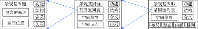
表2 景观基因蕴含的地理信息Tab. 2 The geographical information covered by traditional settlement landscape genes |
| 信息 | 显性/隐性 | 说明 | 示例 |
|---|---|---|---|
| 空间定位信息(空间基准、地理坐标、空间分布) | 隐性 | 景观基因的地理空间位置特征以及在空间中的分布状态等的属性信息 | 大地坐标系、空间坐标、分布范围 |
| 载体信息 | 显性 | 景观基因载体的属性特征信息 | 窗棂的镂空雕饰 |
| 历史信息 | 显性 | 景观基因的历史背景与演化等信息 | 牌坊记载的历史信息 |
| 文化信息(建筑特征、文化特征、环境特征、聚落布局) | 显性 | 传统聚落的传统建筑、传统习俗、传统信仰、地理环境与规划布局、空间形态等重要特征信息 | 合院式建筑的形制、传统的宗族血缘文化、聚落周边的山、河流等、兰溪诸葛村的八卦布局 |
表3 传统聚落空间综合格局特征举例Tab. 3 A few cases of spatial layout models of traditional settlements |
| 聚落示例 | 格局特征 | 含义说明 |
|---|---|---|
| 汝城金山村 | 四象 | 周边山体寓意为“青龙、白虎、朱雀、玄武” |
| 岳阳张谷英村 | 龙形 | 周边的山、渭洞河,以及村口立石、石桥等寓意为龙头、龙身、龙珠、龙须等要素 |
| 兰溪诸葛村 | 八卦 | 周边的山体寓意为八卦的方位 |
| 黟县宏村 | 青牛 | 周边的山体与树木,村中的道路、池塘等寓意为牛头、牛身、牛胃 |
| 道县楼田村 | 负阴抱阳 | 村后的道山为阴,村前平坦的沼泽地为阳 |
| 会同高椅村 | 梅花阵 | 村落封闭环境中的五个自然村寓意为五点梅花 |
表4 传统聚落空间形态特征指标体系Tab. 4 A metric system of spatial forms for traditional settlements |
| 依据 | 尺度特征 | 景观指标 | 形态的景观特征 | 数学特征 |
|---|---|---|---|---|
| 聚落要素的空间距离 | 构成要素尺度 | 最邻近距离指数 | 构成要素的聚集特征 | 空间统计学特征 |
| 紧凑度指数 | ||||
| 聚落空间的分割状态 | 聚落空间尺度 | 边界密度指数 | 聚落空间的分割特征 | |
| 特征信息指数 | ||||
| 聚落的形状特征 | 形状指数 | 聚落空间的整体形状 | 几何特征 |
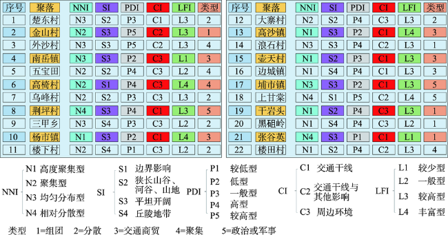
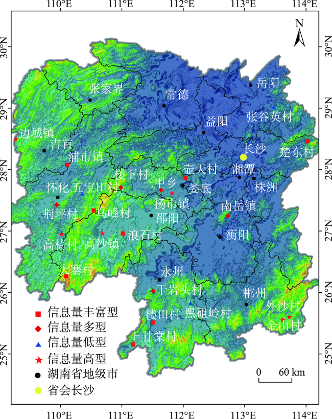
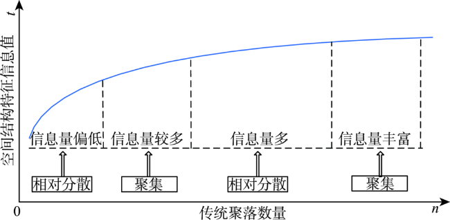
表5 湖南省传统聚的空间结构特征信息量Tab. 5 The results of spatial structural informationof traditional settlements in Hunan Province |
| 聚落名称 | 空间结构特征信息量 | 聚落名称 | 空间结构特征信息量 |
|---|---|---|---|
| 楚东村 | 13.39 | 大寨村 | 12.92 |
| 金山村 | 14.79 | 高沙镇 | 13.84 |
| 外沙村 | 13.66 | 浪石村 | 12.19 |
| 南岳镇 | 12.06 | 壶天村 | 12.71 |
| 五宝田 | 9.82 | 边城镇 | 14.46 |
| 高椅村 | 13.85 | 浦市镇 | 12.48 |
| 乌峰村 | 12.36 | 楼田村 | 12.78 |
| 荆坪村 | 11.22 | 上甘棠 | 12.50 |
| 三甲乡 | 11.72 | 干岩头 | 11.84 |
| 杨市镇 | 15.29 | 黑砠岭 | 10.75 |
| 楼下村 | 11.03 | 张谷英 | 7.62 |
| [1] |
胡洪彬. 十九大以来新时代社会主要矛盾若干问题研究述评[J]. 理论月刊, 2019(9):23-32.
[
|
| [2] |
黄宗良, 项佐涛. 实现中华民族伟大复兴的三大里程碑与世界社会主义[J]. 当代世界与社会主义, 2019(4):23-32.
[
|
| [3] |
张鸣. 发扬伟大五四精神坚定中国特色社会主义文化自信[J]. 科学社会主义, 2019(4):6-8.
[
|
| [4] |
李林. 积极推动优秀传统文化的传承与发展[J]. 人民论坛, 2019(4):140-141.
[
|
| [5] |
胡晶, 刘阳. 论乡村网络信息建设如何融入乡村振兴战略[J]. 学术交流, 2018(12):128-135.
[
|
| [6] |
李国东, 傅才武. 推进文化与科技深度融合是突破文化发展困局的基本政策路径[J]. 中国海洋大学学报(社会科学版), 2017(3):46-54.
[
|
| [7] |
方创琳, 王振波, 刘海猛. 美丽中国建设的理论基础与评估方案探索[J]. 地理学报, 2019,74(4):619-632.
[
|
| [8] |
熊梅. 我国传统民居的研究进展与学科取向[J]. 城市规划, 2017,41(2):102-112.
[
|
| [9] |
陶伟, 程明洋, 符文颖. 城市化进程中广州城中村传统宗族文化的重构[J]. 地理学报, 2015,70(12):1987-2000.
[
|
| [10] |
严钧, 黄颖哲, 任晓婷. 传统聚落人居环境保护对策研究[J]. 四川建筑科学研究, 2009,35(5):223-227.
[
|
| [11] |
中华人民共和国国务院令. 历史文化名城名镇名村保护条例[J]. 中国地名, 2008(5):54-57.
[ Central Government of China. Pact of historic and cultural cities, towns and villages[J]. China Place Name, 2008(5):54-57. ]
|
| [12] |
赵勇, 唐渭荣, 龙丽民, 等. 我国历史文化名镇名村保护的回顾和展望[J]. 建筑学报, 2012(6):12-17.
[
|
| [13] |
胡明星, 董卫. 基于GIS的古村落保护管理信息系统[J]. 武汉大学学报·工学版, 2003,36(3):53-56.
[
|
| [14] |
何川. 湘南传统聚落生态单元的构建经验探索[J]. 建筑科学, 2008,24(2):12-16,35.
[
|
| [15] |
刘沛林. “景观信息链”理论及其在文化旅游地规划中的运用[J]. 经济地理, 2008,28(6):1035-1039.
[
|
| [16] |
张剑. 从东楮岛村看传统聚落建筑本土化设计的低碳思维[J]. 装饰, 2015,263(3):132-133.
[
|
| [17] |
郭武, 关菁华. 中国古建筑的L系统建模新方法[J]. 计算机应用研究. 2012. 29(2):789-792.
[
|
| [18] |
|
| [19] |
陈倩. 传统聚落形态形成机制的方法论探讨[J]. 昆明理工大学学报(社会科学版), 2015,15(1):104-108.
[
|
| [20] |
赵烨, 王建国. 基于形态完整性的传统乡村聚落规划研究—聚落性能化提升规划技术的应用[J]. 城市规划, 2018,42(11):33-40,53.
[
|
| [21] |
陈小辉, 张鹰. 传统聚落综合功能提升关键技术集成与示范[J]. 建筑学报, 2016(12):115-116.
[
|
| [22] |
刘军民, 唐伊娟, 郑建栋. 传统聚落人居环境保护的现状、问题及对策研究—以陕西省米脂窑洞古城为例[J]. 城市发展研究, 2015,22(9):12-15.
[
|
| [23] |
|
| [24] |
|
| [25] |
彭兆荣. 城镇化与逆城镇化:一种新型的双向对流关系—以厦门城中村曾厝垵为例[J]. 中南民族大学学报(人文社会科学版), 2019,39(3):69-73.
[
|
| [26] |
|
| [27] |
陈明星, 叶超, 陆大道, 等. 中国特色新型城镇化理论内涵的认知与建构[J]. 地理学报, 2019,74(4):633-647.
[
|
| [28] |
刘沛林. 古村落文化景观的基因表达与景观识别[J]. 衡阳师范学院学报(社会科学), 2003,24(4):1-8.
[
|
| [29] |
胡最, 刘春腊, 邓运员, 等. 传统聚落景观基因及其研究进展[J]. 地理科学进展, 2012,31(12):1620-1627.
[
|
| [30] |
刘沛林, 刘春腊, 邓运员, 等. 中国传统聚落景观区划及景观基因识别要素研究[J]. 地理学报, 2010,65(12):1496-1506.
[
|
| [31] |
胡最, 郑文武, 刘沛林, 等. 湖南省传统聚落景观基因组图谱的空间形态与结构特征[J]. 地理学报, 2018,73(2):317-332.
[
|
| [32] |
胡最, 刘沛林. 中国传统聚落景观基因组图谱特征[J]. 地理学报, 2015,70(10):1592-1605.
[
|
| [33] |
闾国年, 袁林旺, 俞肇元. 地理学视角下测绘地理信息再透视[J]. 测绘学报, 2017,46(10):1549-1556.
[
|
| [34] |
闾国年, 俞肇元, 袁林旺, 等. 地图学的未来是场景学吗?[J]. 地球信息科学学报, 2018,20(1):1-6.
[
|
| [35] |
胡迪, 闾国年, 江南, 等. 地理与历史双重视角下的历史GIS数据模型[J]. 地球信息科学学报, 2018,20(6):713-720.
[
|
| [36] |
陈军, 刘万增, 武昊, 等. 基础地理知识服务的基本问题与研究方向[J]. 武汉大学学报·信息科学版, 2019,44(1):38-47.
[
|
| [37] |
马照亭, 李成名, 印洁. 丝绸之路经济带的地理空间认知框架研究[J]. 测绘科学, 2015,40(10):48-53.
[
|
| [38] |
|
| [39] |
翟卫欣, 段杰雄, 童晓冲, 等. 基于空间网格的多尺度人文地理特征分析[J]. 测绘学报, 2016,45(S1):85-89.
[
|
| [40] |
胡海, 游涟, 宋丽丽, 等. 地球格网化剖分及其度量问题[J]. 测绘学报, 2016,45(S1):56-65.
[
|
| [41] |
|
| [42] |
于少波, 吴玲达, 张喜涛. 基于形式概念分析的空间信息表征模型研究[J]. 通信学报, 2017,38(S2):78-85.
[
|
| [43] |
李德仁. 从测绘学到地球空间信息智能服务科学[J]. 测绘学报, 2017,46(10):1207-1212.
[
|
| [44] |
胡最, 刘沛林, 邓运员, 等. 汝城非物质文化遗产的景观基因识别——以香火龙为例[J]. 人文地理, 2015,30(1):64-69.
[
|
| [45] |
胡最, 刘沛林, 曹帅强. 湖南省传统聚落景观基因的空间特征[J]. 地理学报, 2013,68(2):219-231.
[
|
| [46] |
胡最, 邓运员, 刘沛林, 等. 传统聚落景观基因的符号机制[J]. 地理学报, 2020,75(4):789-803.
[
|
| [47] |
刘沛林, 刘春腊, 邓运员, 等. 我国古城镇景观基因“胞—链—形”的图示表达与区域差异研究[J]. 人文地理, 2011,26(1):94-99.
[
|
| [48] |
王昀. 传统聚落结构中的空间概念[M]. 北京: 中国建筑工业出版社, 2009.
[
|
| [49] |
浦欣成. 传统乡村聚落二维平面整体形态的量化方法研究[D]. 杭州:浙江大学, 2012.
[
|
| [50] |
|
| [51] |
EschT,
|
| [52] |
|
| [53] |
|
| [54] |
胡最. 湖南省传统聚落景观图谱研究[D]. 南京:南京师范大学, 2015.
[
|
| [55] |
|
| [56] |
|
| [57] |
业祖润. 传统聚落环境空间结构探析[J]. 建筑学报, 2001(12):21-24.
[
|
/
| 〈 |
|
〉 |