
民航客机平台夜光遥感方法在香港经济活动变化检测中的应用
|
王永全(1994— ),男,安徽五河人,硕士生,主要从事系留无人机和遥感数据分析及应用研究。E-mail:1058309323@qq.com |
收稿日期: 2019-09-25
要求修回日期: 2020-03-24
网络出版日期: 2020-07-25
基金资助
深圳市科创委研究项目(KQJSCX20180328093453763)
深圳市科创委研究项目(JCYJ20180305125101282)
国家自然科学基金项目(41974006)
自然资源部城市国土资源监测与仿真重点实验室(KF-2018-03-004)
深圳大学教师启动项目(2018073)
版权
Preliminary Application of Night Light Remote Sensing based on Passenger Aircraft in Hong Kong Economic Activity Zone Changes Identification
Received date: 2019-09-25
Request revised date: 2020-03-24
Online published: 2020-07-25
Supported by
Shenzhen Scientific Research and Development Funding Program(KQJSCX20180328093453763)
Shenzhen Scientific Research and Development Funding Program(JCYJ20180305125101282)
National Nature Science Foundation of China(41974006)
Key Laboratory of Urban Land Resources Monitoring and Simulation of Ministry of Natural Resources(KF-2018-03-004)
Shenzhen University NatureScienceFunding Program(2018073)
Copyright
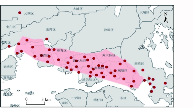
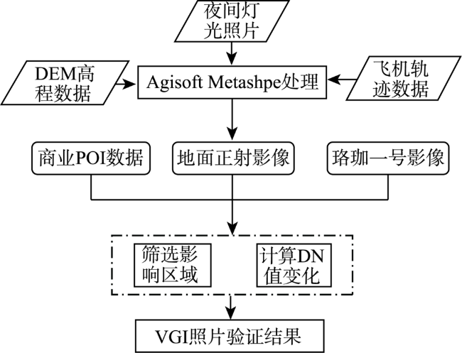
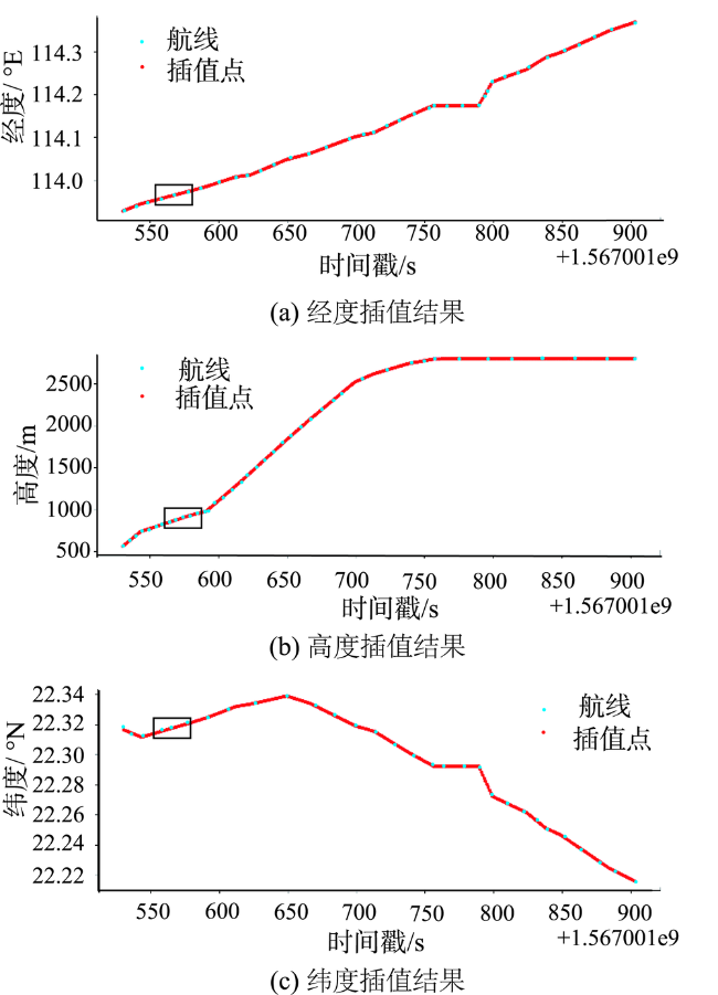
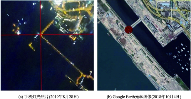
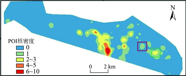
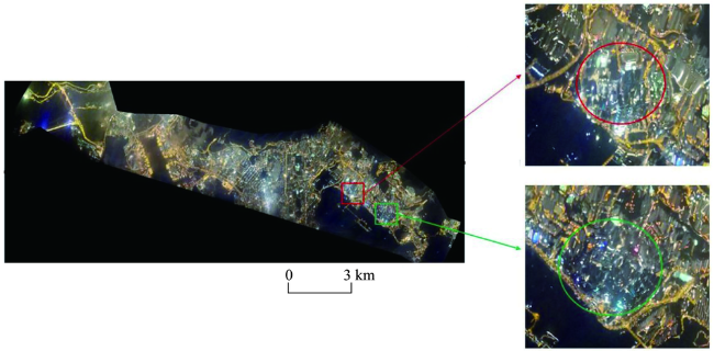
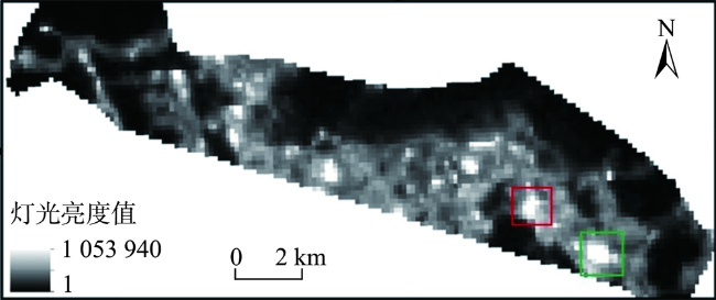
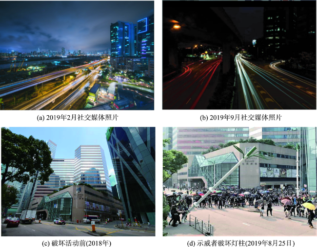
大规模持续的示威游行活动会影响一个城市的经济活动。自2019年6月开始,香港地区持续性的示威游行活动对多个行业产生冲击,香港地区经济受到一定程度影响。快速准确地识别出经济活动受影响区域将有助于政府进行准确损失评估和制定有效的经济恢复政策。本文首次提出使用民航客机夜光遥感结合VGI数据识别经济活动受影响区域的方法。首先在民航客机平台上用手机获取了研究区域2019年8月28日的高度重叠的照片,然后基于摄影测量技术对照片进行拼接处理生成夜光遥感影像,再与珞珈一号-01星夜光遥感影像、POI密度图对比初步筛选出受影响区域。最后通过VGI照片数据进行验证,检测出观塘区有2个经济活动下降的区域,并做了定量分析,发现在观塘区有2个区域的DN值相关比例分别下降了9.52%和19.42%。利用本文的方法能快速识别香港经济活动受影响区域,对于研究其他城市的经济变化有着借鉴意义,在城市精准治理方面也有重要的应用价值。

王永全 , 汪驰升 , 王乐涵 , 佘佳霓 , 李清泉 . 民航客机平台夜光遥感方法在香港经济活动变化检测中的应用[J]. 地球信息科学学报, 2020 , 22(5) : 1153 -1160 . DOI: 10.12082/dqxxkx.2020.190549
Large-scale sustained demonstrations will seriously affect the stability of social order. Since June 2019, Hong Kong's economy has been affected to some extent by the impact of continuous demonstrations on various industries. Rapid and accurate identification of areas affected by demonstrations plays a very important role in loss assessment, economic recovery, and government governance. In this paper, we proposed a novel method to identify the affected areas using night light remote sensing and VGI data. Firstly, we captured the highly overlapping photographs of the study area by a mobile phone on passenger aircraft on August 28, 2019. Following regular photogrammetry steps, night light remote sensing image was generated. Then we compared it with POI density maps and Luojia-01 night light image, and initially marked the affected areas, which were further validated by VGI photos. We finally confirmed two affected areas in Kwun Tong District. A simple quantitative analysis was performed to assess the influence on affected areas. We conclude that the proposed method can quickly identify the areas where economic activities are affected in Hong Kong. Our method can also be used to study economic changes in other cities, which is of great application value in precise urban governance.
图7 研究区珞珈一号01星夜光遥感影像注:红色线框范围为区域1,绿色线框范围为区域2。 Fig. 7 Lujia-01 night light remote sensing image of the study area |
表1 区域1与区域2中POI对应的DN值与所占比值变化率Tab. 1 The DN values and the percentage change ratios of the POIs in area 1 and area 2 |
| 区域 | POI数量/个 | 民航客机夜光遥感DN平均值() | 珞珈一号-01星DN平均值() | 比例1()/% | 比例2()/% | 变化率(V)/% |
|---|---|---|---|---|---|---|
| 区域1 | 27 | 121.50 | 3280.47 | 0.84 | 0.76 | 9.52 |
| 区域2 | 94 | 120.83 | 11 358.29 | 1.03 | 0.83 | 19.42 |
| [1] |
陶然, 苏福兵, 陆曦, 等. 经济增长能够带来晋升吗?—对晋升锦标竞赛理论的逻辑挑战与省级实证重估[J]. 管理世界, 2010(12):13-26.
[
|
| [2] |
范强, 吕建东, 李淼. 利用夜光数据的东北三省国内生产总值预测[J]. 遥感信息, 2019,34(4):3-10.
[
|
| [3] |
韩向娣, 周艺, 王世新, 等. 夜间灯光遥感数据的GDP空间化处理方法[J]. 地球信息科学学报, 2012,14(1):128-136.
[
|
| [4] |
|
| [5] |
李德仁, 李熙. 论夜光遥感数据挖掘[J]. 测绘学报, 2015,44(6):591-601.
[
|
| [6] |
李德仁, 余涵若, 李熙. 基于夜光遥感影像的“一带一路”沿线国家城市发展时空格局分析[J]. 武汉大学学报·信息科学版, 2017,42(6):711-720.
[
|
| [7] |
江威, 何国金, 彭燕, 等. 夜光遥感在“一带一路”战略中的应用潜力展望[J]. 中国科学院大学学报, 2017,34(3):296-303.
[
|
| [8] |
|
| [9] |
|
| [10] |
单杰. 从专业遥感到大众遥感[J]. 测绘学报, 2017,46(10):1434-1446.
[
|
| [11] |
|
| [12] |
崔萌, 谢曹东, 单杰. 面向内容的众源影像聚合检索与智能筛选[J]. 测绘科学, 2019,44(3):165-171.
[
|
| [13] |
王玉娴, 段建波, 刘士彬, 等. 基于众包的遥感灾害监测与评估模型[J]. 国土资源遥感, 2017,29(2):104-109.
[
|
| [14] |
|
| [15] |
|
| [16] |
赵云景, 龚绪才, 杜文俊, 等. PhotoScan Pro软件在无人机应急航摄中的应用[J]. 国土资源遥感, 2015,27(4):179-182.
[
|
| [17] |
|
| [18] |
|
| [19] |
Agisoft dense cloud classification&DTM generation with Agisoft photoscan professional[EB/OL]. http://www.agisoft.ru/tutorials/Photoscan/08/.
|
/
| 〈 |
|
〉 |