
空间综合人文学与社会科学研究综述
|
秦 昆(1972— ),男,湖北随州人,博士,教授,主要研究方向为时空大数据分析、空间综合人文学与社会科学。E-mail:qink@whu.edu.cn |
收稿日期: 2020-05-11
要求修回日期: 2020-05-20
网络出版日期: 2020-07-25
基金资助
国家重点研发计划项目(2017YFB0503604)
国家自然科学基金项目(41471326)
版权
A Review of Spatially Integrated Humanities and Social Sciences
Received date: 2020-05-11
Request revised date: 2020-05-20
Online published: 2020-07-25
Supported by
National Key Research and Development Program of China(2017YFB0503604)
National Natural Science Foundation of China(41471326)
Copyright
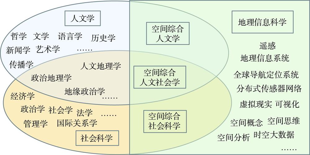
地理信息科学与哲学、历史、文学、艺术、社会学、经济学、政治学、管理学等人文学与社会科学进行了全面的深度融合。一方面,地理信息科学领域的学者积极拓展研究领域,为人文学与社会科学领域的学者提供空间化、可视化的技术手段;另一方面,人文学与社会科学领域的学者积极学习和掌握地理信息技术,在研究中积极引入空间思维和空间可视化方法。同时,一些适用于人文学与社会科学研究者的开放平台、代码和工具不断涌现。本文在对空间综合人文学与社会科学的最新进展进行全面总结的基础上,探讨了空间人文学与社会科学研究的思路和框架,并分别对该框架各分支的研究进展进行了梳理和评述,包括:历史GIS,文学GIS,语言学GIS,GIS与哲学、人类动力学、人文地理学等;以及GIS与政治学及国际关系学,GIS与管理学、空间计量经济学、社会地理计算、空间社会网络与空间交互网络、犯罪地理学、健康地理与公共卫生学等。接着,本文对空间综合人文学与社会科学的研究方法进行了分析,包括:空间思维与空间计量、认知心理学与空间认知、空间可视化与虚拟地理分析、平台研发等。最后,对空间综合人文学与社会科学研究的关键问题和未来发展方向进行了展望。
秦昆 , 林珲 , 胡迪 , 许刚 , 张晓祥 , 卢宾宾 , 叶信岳 . 空间综合人文学与社会科学研究综述[J]. 地球信息科学学报, 2020 , 22(5) : 912 -928 . DOI: 10.12082/dqxxkx.2020.200232
Humanities and social sciences are undergoing the transformation of quantification and spatialization. The Geographical Information Science (GIS), with powerful functions of spatial data management, spatial analysis and geo-visualization, has been widely used in humanities and social sciences in the era of big data, resulting in an emerging inter-disciplinary field that is Spatial Integrated Humanities and Social Sciences (SIHSS). SIHSS can provide new comprehensive solutions to practical problems that are difficult to solve in a single discipline. Since the first forum on spatially integrated humanities and social sciences was held at the Chinese University of Hong Kong in 2009, this new inter-discipline has developed vigorously and achieved significant progress. We comprehensively summarized the progress of this new field on the tenth forum, held at Wuhan University in 2019. GIS has been fully integrated with humanities and social sciences, including philosophy, history, literature, art, sociology, economics, politics, and management science. On the one hand, scholars and experts in the field of GIS are actively expanding their research fields to provide spatial and visualization technologies for scholars in fields of humanities and social sciences. On the other hand, scholars in fields of humanities and social sciences are actively learning GIS technologies and bringing spatial thinking into their research. Meanwhile, some open platforms, codes, and tools customized for scholars in fields of humanities and social sciences are constantly emerging. In this paper, based on a comprehensive summary of the recent progress of SIHSS, we first investigated the thought and framework of the research on SIHSS, and then introduced the progress in each detailed direction of SIHSS, including history integrated GIS, literature integrated GIS, linguistics integrated GIS, GIS and philosophy, human dynamics, human geography, politics GIS and, GIS and management science, spatial econometrics, geo-computation for social science, spatial social networks and spatial interaction networks, geography of crime, geography of public health, etc. We also summarized methodologies for the research on SIHSS, including spatial thinking, cognitive psychology and spatial cognition, spatial visualization and virtual geographic analysis, and GIS platform development, etc. Finally, we proposed research directions of SIHSS in the future, including further improving the research framework and developing new methods of SIHSS, combining perspectives of map, data, spatial analysis and visualization, developing online platforms and promoting open data and open source tools, further expanding the application of GIS in humanities and social sciences, and strengthening education and training on SIHSS. We conclude that GIS is about to play an increasingly important role in humanities and social sciences and SHISS will also achieve greater advancement and achievement.
感谢参加第十届空间综合人文学与社会科学论坛的鲍曙明、蔡晓兵、关美宝、何捷、简锦松、姬东鸿、刘仁义、刘信陶、罗教讲、苗长虹、沈体雁、翁子扬、王法辉、王艳东、王兆鹏、萧红、徐磊青、徐永明、应申、张箭飞、张萍、赵耀龙、朱欣焰等学者的讨论!感谢研究生王妮满协助整理参考文献!感谢李德仁院士、马费成教授、龚健雅院士的指导和帮助!
| [1] |
|
| [2] |
林珲, 张捷, 杨萍, 等. 空间综合人文学与社会科学研究进展[J]. 地球信息科学, 2006,8(2):30-37.
[
|
| [3] |
林珲, 赖进贵, 周成虎. 空间综合人文学与社会科学研究[M]. 北京: 科学出版社, 2010.
[
|
| [4] |
|
| [5] |
马青, 许盘清, 曾志雄, 等. 历史地图优化表达与设计方法——以前四史地图集为例[J]. 南京师范大学学报:工程技术版, 2013,13(2):54-60,73.
[
|
| [6] |
刘龙雨, 胡迪. 《读史方舆纪要》数据库建设中地名解析的原则与方法[J]. 江苏科技大学学报(社会科学版), 2014,14(4):29-34.
[
|
| [7] |
陈述彭, 黄翀. 文化遗产保护与开发的思考[J]. 地理研究, 2005,24(4):489-498.
[
|
| [8] |
闾国年, 陈旻, 温永宁, 等. 华夏家谱GIS平台构建研究[C]// 空间综合人文学与社会科学研究. 北京: 科学出版社, 2010: 114-118.
[
|
| [9] |
胡迪, 温永宁, 闾国年, 等. 基于GIS的家谱资源整合集成研究[J]. 人文地理, 2012,27(1):50-53.
[
|
| [10] |
陈刚. 超媒体地理信息技术在六朝建康历史地理研究中的应用刍议[J]. 南京晓庄学院学报, 2004,20(3):41-46.
[
|
| [11] |
李凡, 符国强, 齐志新. 佛山历史文化地理信息系统设计和实践的探讨[J]. 佛山科学技术学院学(自然科学版), 2009,27(2):59-64.
[
|
| [12] |
张萍. 丝绸之路历史地理信息系统建设的构想及其价值与意义[J]. 陕西师范大学学报(哲学社会科学版), 2016,45(1):5-11.
[
|
| [13] |
|
| [14] |
|
| [15] |
|
| [16] |
|
| [17] |
|
| [18] |
周丙锋, 周文业, 赵文吉. 中国历史地理数字化应用平台研究[J]. 测绘科学, 2008,33(4):199-202.
[
|
| [19] |
王兆鹏. 建设中国文学数字化地图平台的构想[J]. 文学遗产, 2012,2:131-133.
[
|
| [20] |
|
| [21] |
|
| [22] |
王兆鹏, 王艳. 唐代诗歌版图的静态分布与动态变化——基于《唐宋文学编年系地信息平台》的数据分析[J]. 中南民族大学学报(人文社会科学版), 2020,40(1):102-106.
[
|
| [23] |
张维佳. 方言研究与方言视图的数字化[J]. 中国语文研究, 2004(2):77-89.
[
|
| [24] |
沈力, 冯良珍, 中野尚美. 用GIS手段解读混合方言的成因——以灵石高地为例[J]. 语言教学与研究, 2011(5):30-39.
[
|
| [25] |
郑锦全. 语言学——结合人文关怀与社会应用的学科[J]. 暨南大学(哲学社会科学版), 2005,27(5):94-98.
[
|
| [26] |
王法辉. 社会科学和公共政策的空间化和GIS的应用[J]. 地理学报, 2011,66(8):1089-1100.
[
|
| [27] |
萧红. 中国语言地理(第一集)[M]. 武汉: 崇文书局出版社, 2017.
[
|
| [28] |
张义. 基于MAPGIS的中国历史方言地理信息系统(CHDGIS)设计与实现[D]. 武汉:华中科技大学, 2006.
[
|
| [29] |
刘颖, 赵耀龙, 杨锦, 等. 方言地理信息系统与藏语方言信息化[J]. 热带地貌, 2019,40(1):6-11.
[
|
| [30] |
|
| [31] |
|
| [32] |
李德仁, 崔巍. 地理本体与空间信息多级网格[J]. 测绘学报, 2006,35(2):143-148.
[
|
| [33] |
崔巍, 汤世明, 李荣, 等. 用地理本体和相对高程识别遥感对象的方法研究[J]. 武汉理工大学学报(交通科学与工程版), 2013,37(4):695-698.
[
|
| [34] |
李志林, 王继成, 谭诗腾, 等. 地理信息科学中尺度问题的30年研究现状[J]. 武汉大学学报·信息科学版, 2018,43(12):2233-2242.
[
|
| [35] |
|
| [36] |
|
| [37] |
樊超, 郭进利, 韩筱璞, 等. 人类行为动力学研究综述[J]. 复杂系统与复杂性科学, 2011,8(2):1-17.
[
|
| [38] |
周涛, 韩筱璞, 闫小勇, 等. 人类行为时空特性的统计力学[J]. 电子科技大学学报, 2013,42(4):481-540.
[
|
| [39] |
|
| [40] |
萧世伦, 方志祥, 陈碧宇. 城市人群活动时空分析[M]. 北京: 科学出版社, 2017.
[
|
| [41] |
|
| [42] |
|
| [43] |
方创琳, 周尚意, 柴彦威, 等. 中国人文地理学研究进展与展望[J]. 地理科学进展, 2011,30(12):1470-1478.
[
|
| [44] |
|
| [45] |
孙中伟, 路紫. 我国“人文地理学以信息为对象的研究”: 15年发展回顾[J]. 地球科学进展, 2006,21(9):49-54.
[
|
| [46] |
顾朝林, 陈璐. 人文地理学的发展历程及新趋势[J]. 地理学报, 2004,59(z1):11-20.
[
|
| [47] |
张捷, 顾朝林. 计算机网络信息空间(Cyberspace)的人文地理学研究进展与展望[J]. 地理科学, 2000,20(4):368-374.
[
|
| [48] |
|
| [49] |
|
| [50] |
|
| [51] |
|
| [52] |
秦昆, 罗萍, 姚博睿. GDELT数据网络化挖掘与国际关系分析[J]. 地球信息科学学报, 2019,21(1):14-24.
[
|
| [53] |
|
| [54] |
刘慧. 国际关系的网络分析研究简评[J]. 国际观察, 2010(6):17-23.
[
|
| [55] |
潘峰华, 赖志勇, 葛岳静. 社会网络分析方法在地缘政治领域的应用[J]. 经济地理, 2013,33(7):15-21.
[
|
| [56] |
|
| [57] |
|
| [58] |
汪波. 公共管理科学方法创新: GIS方法与公共管理数字化[J]. 武汉科技大学学报(社会科学版), 2014(2):99-102,122.
[
|
| [59] |
梁怡. 人工智能、空间分析与空间决策[J]. 地理学报, 1997,52(s1):104-113.
[
|
| [60] |
|
| [61] |
|
| [62] |
|
| [63] |
|
| [64] |
|
| [65] |
孙久文, 姚鹏. 空间计量经济学的研究范式与最新进展[J]. 经济学家, 2014(7):27-35.
[
|
| [66] |
|
| [67] |
|
| [68] |
|
| [69] |
|
| [70] |
|
| [71] |
|
| [72] |
罗俊, 李凤翔. 计算社会科学视角下的数据观[J]. 吉首大学学报(社会科学版), 2018,39(2):17-25.
[
|
| [73] |
|
| [74] |
|
| [75] |
|
| [76] |
|
| [77] |
|
| [78] |
闫小勇. 空间交互网络研究进展[J]. 科技导报, 2017,35(14):15-22.
[
|
| [79] |
|
| [80] |
张欣. 多层复杂网络理论研究进展:概念、理论和数据[J]. 复杂系统与复杂性科学, 2015,12(2):103-107.
[
|
| [81] |
柳林, 纪佳楷, 宋广文. 基于犯罪空间分异和建成环境的公共场所侵财犯罪热点预测[J]. 地球信息科学学报, 2019,21(11):1655-1668.
[
|
| [82] |
|
| [83] |
|
| [84] |
|
| [85] |
|
| [86] |
|
| [87] |
|
| [88] |
|
| [89] |
|
| [90] |
李海蓉, 杨林生, 王五一, 等. 150年来中国鼠疫的医学地理评估[J]. 地理科学进展, 2001,20(1):73-80.
[
|
| [91] |
杨林生, 陈如桂. 1840年以来我国鼠的时空分布规律[J]. 地理研究, 2000,19(3):243-248.
[
|
| [92] |
别芹芹, 邱冬生, 胡辉, 等. 我国手足口病时空分布特征的GIS分析[J]. 地球信息科学学报, 2010,12(3):380-384.
[
|
| [93] |
|
| [94] |
|
| [95] |
曹志冬, 王劲峰, 高一鸽, 等. 广州 SARS 流行过程的空间模式与分异特征[J]. 地理研究, 2008,27(5):1139-1150.
[
|
| [96] |
|
| [97] |
|
| [98] |
迟文学, 王劲峰, 李新虎, 等. 出生缺陷的空间点格局分析[J]. 环境与健康杂志, 2007,24(4):238-241.
[
|
| [99] |
宫鹏, 徐冰, 梁松. 用遥感和地理信息系统研究传染病时空分布[J]. 中国科学C辑:生命科学, 2006,36(2):184-192.
[
|
| [100] |
周晓农, 胡晓抒, 孙宁生, 等. 地理信息系统应用于血吸虫病的监测II. 流行程度的预测[J]. 中国血吸虫病防治杂志, 1999,11(2):66-70.
[
|
| [101] |
韩卫国, 王劲峰, 刘纪远, 等. SARS 时空分析系统的设计与实现[J]. 计算机工程, 2005,31(8):40-42.
[
|
| [102] |
|
| [103] |
|
| [104] |
吴建军, 孔云峰, 李斌 .基于 GIS 的农村医疗设施空间可达性分析——以河南省兰考县为例[J]. 人文地理, 2008,23(5):37-42.
[
|
| [105] |
王远飞, 张超. GIS 和引力多边形方法在公共设施服务域研究中的应用——以上海浦东新区综合医院为例[J]. 经济地理, 2006,25(6):800-803.
[
|
| [106] |
周成虎, 裴韬, 杜云艳, 等. 新冠肺炎疫情大数据分析与区域防控政策建议[J]. 中国科学院院刊, 2020,35(2):200-203.
[
|
| [107] |
|
| [108] |
刘张, 千家乐, 杜云艳, 等. 基于多源时空大数据的区际迁徙人群多层次空间分布估算模型——以COVID-19疫情期间自武汉迁出人群为例[J]. 地球信息科学学报, 2020,22(2):147-160.
[
|
| [109] |
|
| [110] |
|
| [111] |
|
| [112] |
|
| [113] |
|
| [114] |
|
| [115] |
|
| [116] |
|
| [117] |
鲁学军, 秦承志, 张洪岩, 等. 空间认知模式及其应用[J]. 遥感学报, 2005,9(3):277-285.
[
|
| [118] |
高俊, 龚建华, 鲁学军, 等. 地理信息科学的空间认知研究(专栏引言)[J]. 遥感学报, 2008,12(2):338.
[
|
| [119] |
张琬卿, 赵书宁, 张冬韵, 等. 尺度对人口地图空间分异规律认知的影响[J]. 地球信息科学学报, 2018,20(10):1396-1402.
[
|
| [120] |
董卫华, 廖华, 詹智成, 等. 2008年以来地图学眼动与视觉认知研究新进展[J]. 地理学报, 2019,74(3):599-614.
[
|
| [121] |
|
| [122] |
龚建华, 周洁萍, 徐珊, 等. SARS传播动力学模型及其多智能体模拟研究[J]. 遥感学报, 2006,10(6):829-835.
[
|
| [123] |
|
| [124] |
|
| [125] |
|
| [126] |
|
| [127] |
|
/
| 〈 |
|
〉 |