
基于大规模手机位置数据的城市潜在自行车出行需求评估
|
周亚娟(1993— ),女,安徽安庆人,硕士生,从事地理信息服务与时空数据挖掘研究。E-mail: 1184310214@qq.com |
收稿日期: 2019-10-24
要求修回日期: 2020-12-12
网络出版日期: 2020-08-25
基金资助
国家重点研发计划项目(2017YFB0503500)
中国博士后科学基金(2019M652244)
版权
Estimating the Potential Demand for Bicycle Travel based on Large-scale Mobile Phone Location Data
Received date: 2019-10-24
Request revised date: 2020-12-12
Online published: 2020-08-25
Supported by
National Key R & D Program of China(2017YFB0503500)
Supported by China Postdoctoral Science Foundation(2019M652244)
Copyright
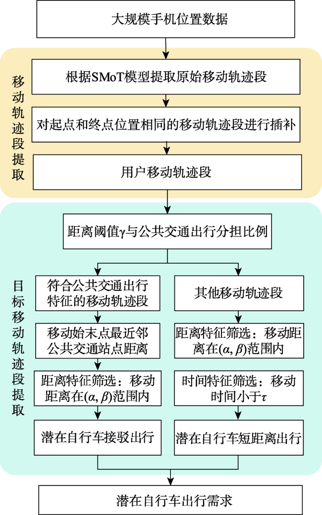
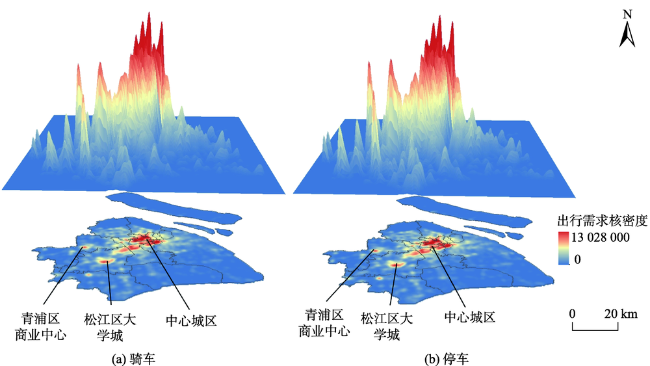
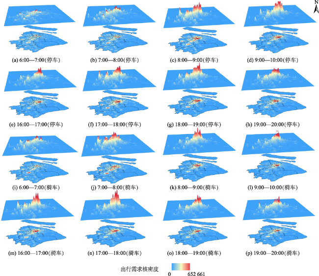
潜在自行车出行是指可能会使用自行车作为交通工具的出行,评估潜在自行车出行需求能够帮助指导城市自行车资源配置方案的优化。大规模手机位置数据蕴含丰富的人群移动信息,而且具有大样本、低成本的特点,能够用于评估城市潜在自行车出行需求。本文结合自行车出行的时间和距离特征,提出一种基于大规模手机位置数据的潜在自行车出行需求评估方法。该方法以单次出行为分析单元,从手机用户的轨迹中提取出具有短距离出行特征和公共交通接驳出行特征的移动轨迹段,并根据该移动轨迹段评估潜在自行车出行需求。基于该方法,利用上海市大规模手机位置数据评估上海市潜在自行车出行需求并分析其时空分布特征,发现在空间上,潜在自行车短距离出行需求主要分布在城市中心和郊区的商业中心,而公共交通接驳的自行车需求主要分布在郊区。在时间上,上午,自行车出行需求从非中心城区向中心城区聚拢;晚上,上海市自行车出行骑车与停车需求从中心城区向非中心城区扩散。

周亚娟 , 赵志远 , 吴升 , 方志祥 , 陈佐旗 . 基于大规模手机位置数据的城市潜在自行车出行需求评估[J]. 地球信息科学学报, 2020 , 22(6) : 1282 -1293 . DOI: 10.12082/dqxxkx.2020.190623
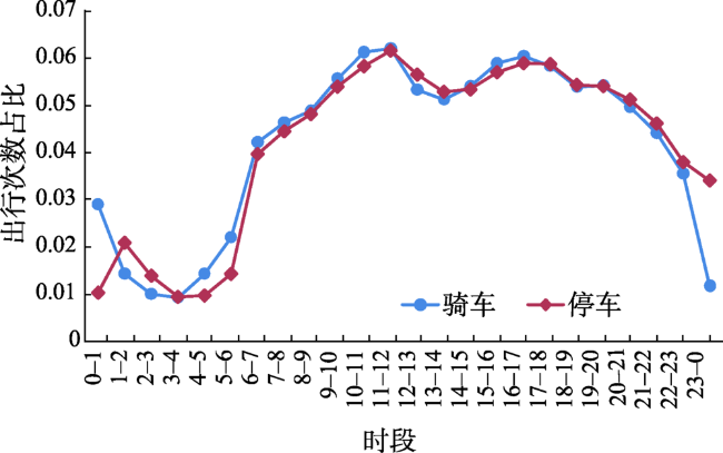
The potential bicycle travel demand indicates the travel demand that could potentially be served by bicycles. Assessing the potential bicycle travel demand can help to optimize the allocation of the related infrastructure (e.g., bike parking areas and bike lanes) in cities. Mobile phone location data have the advantage of providing low-cost and large-scale sample sizes that contain rich human mobility information. The data can be used to estimate the potential bicycle travel demand. Based on the spatiotemporal characteristics of daily bicycle travel, we proposed a method for assessing the potential bicycle travel demand from large-scale mobile phone location data. Specifically, each individual instance of travel was taken as a sample for the analysis. First, we used the Stops and Moves of a Trajectory (SMoT) model to extract the movement trajectory segments of the users. Second, we identified a "tour" pattern for the trajectory segments, where the start location and the end location were the same. Then, the location that was at the furthest point from the start location was used to divide the movement trajectory segment into two segments. Finally, the movement trajectory segments that were characterized by short distances and those in which the "last mile" of the travels was served by the public transport system were extracted for further assessment of the potential bicycle travel demand. In this study, Shanghai was chosen as the example city. Through our proposed method, we assessed and analyzed the spatiotemporal characteristics of daily bicycle travel in Shanghai to determine the potential bicycle travel demand. From a spatial perspective, we found the following: (1) the potential bicycle travel demand in Shanghai was mainly concentrated in the downtown areas and commercial centers in the suburb areas; (2) the potential bicycle travel demand in the downtown areas and commercial central urban areas was stable, while the potential bicycle travel demand in the suburban areas tended to be variable; and (3) most of the “last mile” demands were located in the suburb areas, which showed that the characteristics of the “last mile” demands at different public transport stations varied. From a temporal perspective, several patterns could be observed during the morning and evening rush hours: (1) the potential bicycle travel demand in the central urban area continued to remain relatively high; (2) the potential bicycle travel demand in the suburbs in the Songjiang and Qingpu districts had relatively large differences; (3) the potential bicycle travel demand was concentrated in the direction of the central urban area from the noncentral urban areas in the morning, while the potential bicycle travel demand spread from the central urban areas to the noncentral urban areas in the evening; and (4) the potential bicycle travel demand of Shanghai showed a double-peak characteristic (at 11:00—12:00 and 16:00—17:00). The “last mile” type demand also had two peaks (at 7:00—9:00 and 17:00—18:00).
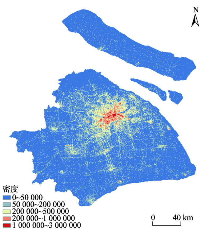
图5 2012年包含基站的分布密度Fig. 5 The density distribution of the base stations in the research dataset in 2012 |
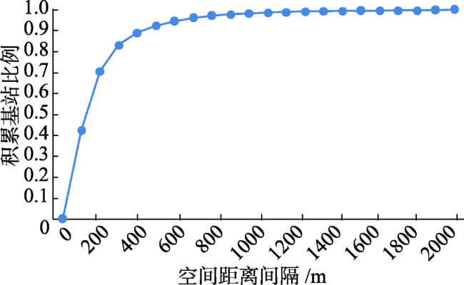
图6 2012年包含基站的覆盖半径概率分布Fig. 6 The probability distribution of the coverage radius of the base stations in the research dataset in 2012 |
表1 手机位置数据Tab. 1 Mobile phone location data |
| 用户ID | 时间 | 基站经度/° | 基站纬度/° | 类型 |
|---|---|---|---|---|
| BD9D***** | 00:34 | 121.*** | 31.*** | 打电话 |
| BD9D***** | 02:45 | 121.*** | 31.*** | 收短信 |
| … | … | … | … | … |
| BD9D***** | 22:56 | 121.*** | 31.*** | 握手 |
| BD9D***** | 23:32 | 121.*** | 31.*** | 关机 |
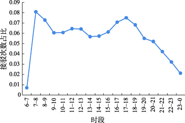
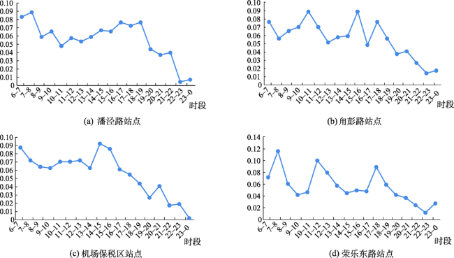
图14 上海市公共交通接驳自行车出行需求时间变化特征Fig. 14 The temporal characteristics of public transportation transfer travel demand in Shanghai |
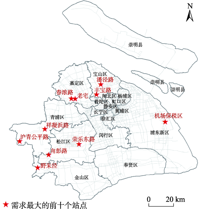
图15 上海市接驳需求最大的前十个公共交通站点空间分布Fig. 15 The spatial distribution of the top 10 public transportation stations with the highest transfer travel demand |
表2 上海市接驳需求量前十的公共交通站点Tab. 2 The top 10 public transportation stations with the highest transfer travel demand |
| 顺序 | 名称 | 区域 | 公交线路 |
|---|---|---|---|
| 1 | 潘泾路 | 宝山区 | 宝山90路 |
| 2 | 甪彭路 | 松江区 | 松江76路 |
| 3 | 机场保税区 | 浦东新区 | 机场八线 |
| 4 | 荣乐东路 | 松江区 | 松江10路 |
| 5 | 野朱泾 | 金山区 | 朱枫线 |
| 6 | 老宅 | 嘉定区 | 嘉定63路,嘉定123路 |
| 7 | 沪青平公路 | 青浦区 | 沪商高速专线 |
| 8 | 丰宝路 | 宝山区 | 宝山85路 |
| 9 | 祥凝浜路 | 青浦区 | 朱家角2路 |
| 10 | 春浓路 | 嘉定区 | 嘉定109路 |
| [1] |
董红召, 吴满金, 刘冬旭, 等. 城市公共自行车系统自然租赁需求估算方法[J]. 浙江大学学报(工学版), 2016,50(2):265-270.
[
|
| [2] |
何流, 陈大伟, 李旭宏, 等. 城市公共自行车租赁点布局优化模型[J]. 武汉理工大学学报(交通科学与工程版), 2012,36(1):129-133.
[ HeL, ChenDW, LiXH, et al. An optimization model of the layout of public bike rental stations[J]. Journal of Wuhan University of Technology(Transportation Science & Engineering). 2012,36(1):129-133. ]
|
| [3] |
|
| [4] |
|
| [5] |
|
| [6] |
林燕平, 窦万峰. 基于ARIMA模型的城市公共自行车需求量短期预测方法研究[J]. 南京师范大学学报(工程技术版), 2016,16(3):36-40.
[
|
| [7] |
|
| [8] |
|
| [9] |
|
| [10] |
|
| [11] |
|
| [12] |
许宁, 尹凌, 胡金星. 从大规模短期规则采样的手机定位数据中识别居民职住地[J]. 武汉大学学报·信息科学版, 2014,39(6):750-756.
[
|
| [13] |
冉斌. 手机数据在交通调查和交通规划中的应用[J].城市交通,2013(1):78-87,38.
[
|
| [14] |
|
| [15] |
徐金垒, 方志祥, 萧世伦, 等. 城市海量手机用户停留时空分异分析——以深圳市为例[J]. 地球信息科学学报, 2015,17(2):197-205.
[
|
| [16] |
钮心毅, 康宁, 王垚, 等. 手机信令数据支持城镇体系规划的技术框架[J]. 地理信息世界, 2019,26(1):18-24.
[
|
| [17] |
|
| [18] |
|
| [19] |
|
| [20] |
|
| [21] |
|
| [22] |
Wang, Wu, Zhang, et al. Indoor location prediction method for shopping malls based on location sequence similarity[J]. ISPRS International Journal of Geo-Information, 2019,8(11):517.
|
| [23] |
|
| [24] |
|
| [25] |
|
| [26] |
|
| [27] |
颜永国. 上海市中心城区居民出行方式调查[J].统计科学与实践,2012(8):12-13.
[
|
| [28] |
陆锡明, 顾啸涛. 上海市第五次居民出行调查与交通特征研究[J].城市交通,2011(5):1-7.
[
|
| [29] |
|
| [30] |
邓力凡, 谢永红, 黄鼎曦. 基于骑行时空数据的共享单车设施规划研究[J]. 规划师, 2017,33(10):82-88.
[
|
/
| 〈 |
|
〉 |
