
郑州市市区风环境模拟研究
|
申鑫杰(1996— ),女,河南驻马店人,硕士生,主要从事城市微气候方面的研究。E-mail: 1395869927@qq.com |
收稿日期: 2019-05-15
要求修回日期: 2019-12-15
网络出版日期: 2020-08-25
基金资助
国家自然科学基金项目(31470029)
河南省科技厅产学研资助项目(142107000101)
河南省高等学校重点科研项目(19A416004)
版权
Research on Urban Wind Environment Simulation: A Case Study of Zhengzhou Central Area
Received date: 2019-05-15
Request revised date: 2019-12-15
Online published: 2020-08-25
Supported by
National Natural Science Foundation of China(31470029)
Industry-University-Research Funded Project of Science and Technology Department of Henan Province(142107000101)
Key Scientific Research Project of Universities in Henan Province(19A416004)
Copyright
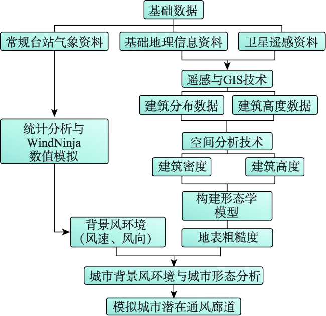
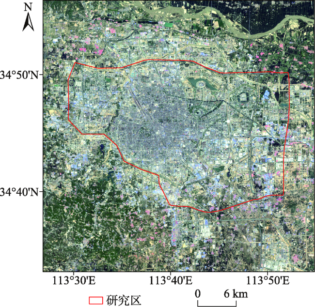
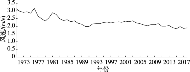
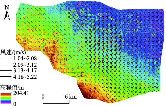
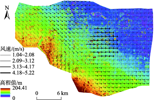
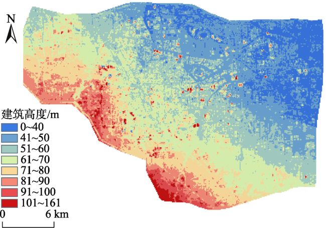
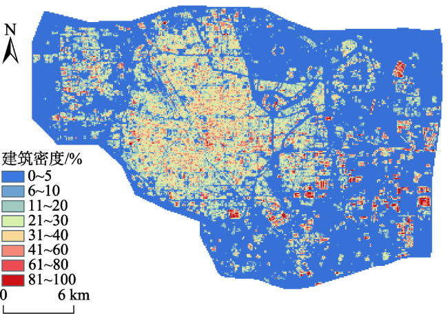
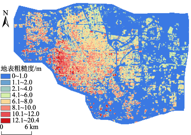
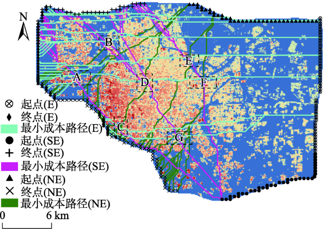
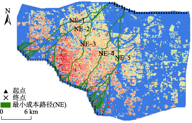
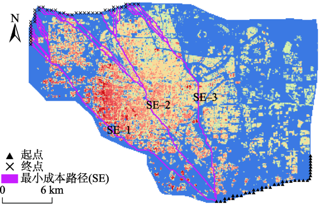
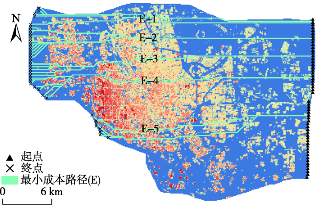
城市风环境是城市微气候研究的一个重要方向,对分析城市热岛效应、空气流通等具有重要意义。本文以郑州市市区为例,使用1971—2018年气象观测数据、2018年建筑分布数据(OSM)和2016年资源三号卫星数据作为数据源,通过运用气象学和GIS技术结合的方法,探究潜在通风廊道,科学量化城市形态对风环境的影响。研究首先借助WindNinja软件,对城市背景风环境进行模拟分析,该计算方法提高了风道定位的精度。然后利用卫星遥感数据制作了数字高程模型(DSM),结合OSM计算下垫面地表粗糙度。进一步借助ArcGIS软件,利用最小成本路径法(LCP)确定城市潜在通风廊道的位置。结果表明:① 郑州市近年来平均风速缓慢下降,平均每10年下降0.26 m/s;全年主导风向东北风进入城市后受城市形态影响在京广铁路线附近以西逐渐转为东北偏东风,其中在京广快速路以东风速较高,在京广快速路以西风速较低;② 金水区西部、中原区、二七区以及管城区的地表粗糙度较高,通风环境较差;金水区东部和惠济区的地表粗糙度较低,通风环境较好;③根据盛行风向模拟的潜在通风廊道,其共同特点是趋向于低粗糙度的地区。

申鑫杰 , 赵芮 , 何瑞珍 , 王琦 , 郭煜琛 . 郑州市市区风环境模拟研究[J]. 地球信息科学学报, 2020 , 22(6) : 1349 -1356 . DOI: 10.12082/dqxxkx.2020.190231
Urban wind environment is an important research field of urban climate, which is of great significance to the analysis of urban heat island effect and ventilation. Taking the central area of Zhengzhou city as an example, this paper used meteorological observation data in 1971-2018, the data from ZY-3 satellite in 2016, and then combined with the Open Street Map (OSM) data in 2018 to explore potential ventilation corridors and scientifically quantify the impact of urban form on the wind environment through the combination of meteorology and GIS technology. In this study, the wind environment in urban background was firstly simulated and analyzed with the help of WindNinja software, which improved the accuracy of potential ventilation corridors of the city. The Digital Surface Model (DSM) was made based on the data from ZY-3 satellite in 2016, and then combined with the OSM data in 2018 to calculate the surface roughness of the underlying surface. Then ArcGIS software was used to locate and analyze the location of the potential ventilation corridors in the city by means of the Least Cost Path analysis (LCP). The results were as follows: (1) Average wind speed in Zhengzhou declined slowly with an average rate of 0.26 m/s per decade; The prevailing wind throughout the year was northeast wind, which changed in wind speed and direction after entering the city due to the influence of urban form. In particular, the northeast wind gradually changed to northeast easterly wind in the west of the Beijing-Guangzhou Railway. And the wind speed in the east of the Beijing-Guangzhou Railway was relatively higher than in the west of the Beijing-Guangzhou Railway. (2) The surface roughness of Zhongyuan District, Erqi District, Guancheng District and the western part of Jinshui District was high. The wind speed decreased and the wind direction changed greatly after the prevailing wind entering these study areas, and the overall ventilation environment of those four districts was poor. The surface roughness of the eastern part of Jinshui District and Huiji District was relatively low, with relatively good ventilation conditions. After the prevailing wind entered these areas, the wind speed increased and the wind direction changed less. (3) The common feature of the potential ventilation corridors, which were simulated according to the prevailing wind direction, was that the location tended to be low roughness areas. In these areas, the concentration of ventilation paths was lower and there were more potential ventilation corridors.
表1 粗糙度的摩擦值指标分配Tab. 1 Distribution of friction index values of surface roughness |
| 分配摩擦值 | 地表粗糙度Z0 |
|---|---|
| 25 | Z0<6.3 |
| 50 | 6.3<Z0<11.6 |
| 75 | 11.6<Z0<16.9 |
| 100 | 16.9<Z0<20.4 |
表2 实验区1971—2018年所使用数据列表Tab. 2 List of data used in the study area from 1971 to 2018 |
| 数据源 | 采集日期 | 数据类型 | 分辨率 | 用途 |
|---|---|---|---|---|
| 气象数据 | 1971年1月—2018年12月 | 文本 | — | 计算风速风向 |
| OSM数据 | 2018年3月 | 矢量 | — | 计算地表粗糙度 |
| DSM数据 | 2016年11月 | 栅格 | 4 m×4 m | 计算地表粗糙度 |
图4 郑州市中心区全年风速风向合成流线Fig. 4 Annual wind speed and direction composite flow chart in Zhengzhou central area |
图5 郑州市中心区夏季风速风向合成流线Fig. 5 Wind speed and direction composite flow chart in summer in Zhengzhou central area |
| [1] |
陈红. 郑州市居住区绿色空间布局对风环境的影响效应[D]. 郑州:河南农业大学, 2018.
[
|
| [2] |
任超, 袁超, 何正军, 等. 城市通风廊道研究及其规划应用[J].城市规划学刊,2014(3):52-60.
[
|
| [3] |
张睿, 李红艳. 基于风环境要素的城市通风廊道建设研究综述[J]. 华中建筑, 2018,36(6):44-48.
[
|
| [4] |
尹杰, 詹庆明. 基于GIS和CFD的城市街道通风廊道研究——以武汉为例[J]. 中国园林, 2019,35(6):84-88.
[
|
| [5] |
王伟武, 黎菲楠, 王頔. 城市风道研究动态及走向[J].城市问题,2018(2):36-40.
[
|
| [6] |
任超, 吴恩融,
[
|
| [7] |
|
| [8] |
|
| [9] |
|
| [10] |
|
| [11] |
|
| [12] |
党冰, 房小怡, 吕红亮, 等. 基于气象研究的城市通风廊道构建初探——以南京江北新区为例[J]. 气象, 2017,43(9):1130-1137.
[
|
| [13] |
王梓茜, 程宸, 杨袁慧, 等. 基于多元数据分析的城市通风廊道规划策略研究——以北京副中心为例[J]. 城市发展研究, 2018,25(1):87-96.
[
|
| [14] |
叶锺楠. 我国城市风环境研究现状评述及展望[J]. 规划师, 2015,31(S1):236-241.
[
|
| [15] |
王晓龙. 荆州市中心城区通风廊道规划研究[D]. 荆州:长江大学, 2017.
[
|
| [16] |
张茜, 李国栋, 吴东星. 郑州城市化进程与城市热岛效应关系研究[J]. 城市环境与城市生态, 2016,29(5):1-6.
[
|
| [17] |
|
| [18] |
|
| [19] |
李廷廷. 基于城市形态和地表粗糙度的城市风道构建及规划方法研究[D]. 深圳:深圳大学, 2017.
[
|
| [20] |
詹庆明, 欧阳婉璐, 金志诚, 等. 基于RS和GIS的城市通风潜力研究与规划指引[J]. 规划师, 2015,31(11):95-99.
[
|
| [21] |
|
| [22] |
刘勇洪, 张硕, 程鹏飞, 等. 面向城市规划的热环境与风环境评估研究与应用——以济南中心城为例[J]. 生态环境学报, 2017,26(11):1892-1903.
[
|
| [23] |
郭廓. 基于自然通风效能的大连城市形态设计策略[D]. 大连:大连理工大学, 2015.
[
|
| [24] |
沈娟君, 邱新法, 何永健, 等. 城市建筑迎风面积密度矢量/栅格计算模型对比研究[J]. 地球信息科学学报, 2017,19(11):1433-1441.
[
|
| [25] |
袁钟. “多尺度”的城市风道构建方法与规划策略研究[D]. 西安:西北大学, 2017.
[
|
| [26] |
|
| [27] |
中国气象数据网.地面资料[DB/OL]. http://data.cma.cn/data/cdcindex/cid/6d1b5efbdcbf9a58.html.
[ China meteorological data network. Ground data[DB/OL]. http://data.cma.cn/data/cdcindex/cid/6d1b5efbdcbf9a58.html.]
|
| [28] |
OpenStreetMap.郑州[DB/OL].https://www.openstreetmap.org/search?query=%E9%83%91%E5%B7%9E#map=11/34.7593/113.6524.
[ OpenStreetMap. Zhengzhou[DB/OL].https://www.openstreetmap.org/search?query=%E9%83%91%E5%B7%9E#map=11/34.7593/113.6524. ]
|
| [29] |
中科遥感.卫星数据[DB/OL]. http://www.chinarsgeo.com/list-28-1.html.
[ China RS. Satellite data[DB/OL]. http://www.chinarsgeo.com/list-28-1.html.]
|
| [30] |
杜吴鹏, 房小怡, 刘勇洪, 等. 基于气象和GIS技术的北京中心城区通风廊道构建初探[J].城市规划学刊,2016(5):79-85.
[
|
/
| 〈 |
|
〉 |
