
基于遥感的迪拜哈翔清洁能源电站项目监管方法
|
蒋 瑜(1995— ),男,湖南湘阴人,硕士生,主要研究方向为工程遥感。E-mail:654528023@qq.com |
收稿日期: 2019-09-28
要求修回日期: 2019-12-04
网络出版日期: 2020-09-25
基金资助
中国科学院A类战略性先导科技专项“地球大数据科学工程”(XDA19030304)
中国科学院青年创新促进会(2017089)
版权
Supervision Method of Hassyan Clean Energy Power Station Project in Dubai based on Remote Sensing
Received date: 2019-09-28
Request revised date: 2019-12-04
Online published: 2020-09-25
Supported by
Strategic Priority Research Program of Chinese Academy of Sciences(XDA19030304)
Youth Innovation Promotion Association of Chinese Academy of Sciences(2017089)
Copyright
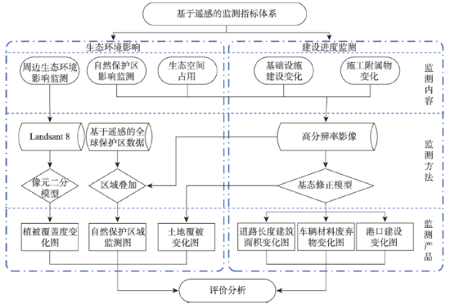
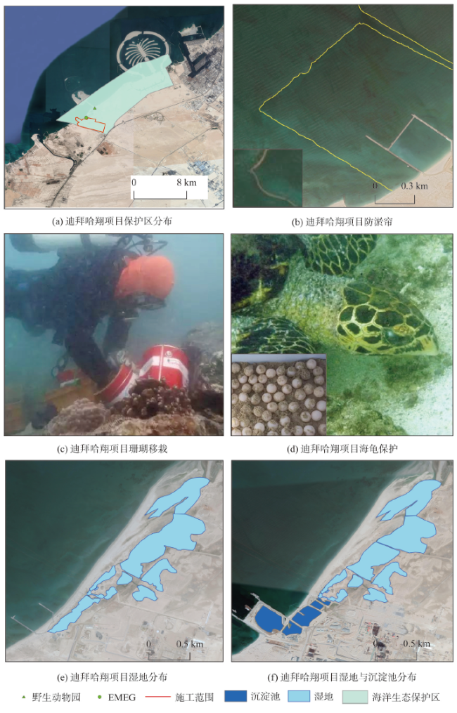
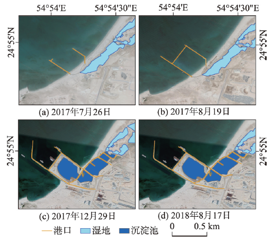
自“一带一路”倡议提出以来,中国企业在“一带一路”沿线国家投资、承建了大量基础设施项目,这些项目在促进当地经济发展的同时,不可避免地给当地生态环境带来一定的影响。目前国内主要采用统计调查等方法进行监管,缺乏直接的境外工程监管手段。遥感技术能为境外工程项目监管提供新方法、新手段,但地面调查数据难以获取是境外项目监管面临的重要问题。针对该问题,本文以迪拜哈翔清洁能源电站项目为例,结合遥感技术(RS)和地理信息系统(GIS)的优势,提出了一种境外工程的遥感监管方法。① 针对生态环境影响和工程建设进度两项监测内容,建立了遥感监测技术指标体系;② 基于2016—2018年30 m 分辨率的Landsat 8影像和0.5 m分辨率的WorldView-2影像,利用像元二分模型原理、基态修正模型等方法,从植被覆盖度变化、生态空间占用、自然保护区域影响、工程设施建设、施工附属设施变化5个方面对项目生态环境影响和建设进度情况进行监测;最后通过时序影像和监测产品对比,分析了工程建设对生态环境的影响和工程建设进度情况。结果表明:① 该方法能反映工程在建设过程中对周围生态环境的影响,能准确地监测出迪拜哈翔清洁能源电站的建设进度,对“一带一路”其它境外项目建设的监管具有重要参考意义;②项目建设后无大面积植被覆盖度降低的现象,植被覆盖度总体由低区间向高区间转化;③ 项目施工占用沙地1.4780 km2,港口建设填海面积达0.1246 km2,0.0604 km2的湿地被改为施工沉淀池,没有占用耕地;④ 通过转移海底珊瑚、设置防淤帘、预留海龟产卵通道等措施有效地减少了该项目对Jebel Ali海洋生态保护区的影响;⑤ 工程设施和附属设施建设进展明显,建筑面积增加了0.14 km2,港口建设围堰总长达3.785 km。
蒋瑜 , 邬明权 , 刘正才 , 黄长军 . 基于遥感的迪拜哈翔清洁能源电站项目监管方法[J]. 地球信息科学学报, 2020 , 22(7) : 1437 -1448 . DOI: 10.12082/dqxxkx.2020.190603
Since the Belt and Road initiative was put forward, Chinese enterprises have invested in and built a large number of infrastructure projects in countries along the Belt and Road region. While promoting the development of local economy, these projects inevitably bring certain impacts on local vegetation, ecology, and environment. However, China mainly adopts the methods of record filing and statistical investigation for supervision, lacking active supervision means for overseas projects. Remote sensing technology can provide new methods and means for the supervision of overseas engineering projects. And it is usually an important problem for the supervision of overseas projects that the ground survey data is difficult to obtain. Aiming at this problem, this paper takes Hassyan Clean Power Station as an example and combines the advantages of Remote Sensing technology (RS) and Geographic Information System (GIS) to propose a remote sensing monitoring method for overseas projects. First, the remote sensing monitoring technology index system is established with ecological environment impact and project construction progress as the main content of monitoring. Then, Based on 2016-2018 Landsat 8 imagery at 30 m resolution and WorldView-2 imagery at 0.5 m resolution, the dimidiate pixel model and the base state amendments model are used to monitor the ecological environment impact and construction progress of the project from five aspects, including vegetation coverage change, ecological space occupation, nature reserve monitoring, infrastructure construction, and appendages change. Finally, this paper analyzes the impact of the project construction on the ecological environment and the progress of the project construction through the comparison of time-series images. The results show that: (1) This method can reflect the influence of the project on the surrounding ecological environment during the construction process and accurately monitor the construction progress of Dubai Hassyan Clean Power Station. This method has important reference significance for the construction supervision of other overseas projects of the Belt and Road Initiative; (2) After the project construction, there is no phenomenon of large-scale vegetation coverage reduction. The vegetation coverage generally changed from low to high; (3) The project construction occupies 1.4780 km2 of sandy land. The reclamation area of the port construction reaches 0.1246 km2, and 0.0604 km2 of wetland is converted into a construction sedimentation pond, without occupying cultivated land; (4) The impact of the project on the Jebel Ali Marine Ecological Reserve is effectively reduced through measures such as the transfer of corals on the sea floor, the installation of anti-fouling curtains, and the reservation of sea turtle spawning channels; (5) Significant progress has been made in the construction of infrastructure and ancillary facilities. The building area has increased by 0.14 km2, and the total number of cofferdams for port construction has reached 3.785 km.
表1 数据用途及主要参数Tab. 1 Data usage and main parameters |
| 用途 | 影像 | 影像来源 | 分辨率/m | 数量 | 日期 |
|---|---|---|---|---|---|
| 周边植被变化监测 | Landsat 8 | USGS | 30 | 2 | 2016-08-11 2018-08-17 |
| 生态空间占用监测 | WorldView-2 | Digital Globe | 0.5 | 2 | 2016-12-01 2018-08-17 |
| 工程建设进度监测 | WorldView-2 | Digital Globe | 0.5 | 6 | 2016-12-01 2017-05-03 2017-07-26 2017-08-19 2017-12-29 2018-08-17 |
表2 迪拜哈翔项目遥感监测指标体系Tab. 2 Remote sensing monitoring index system for Hassyan project in Dubai |
| 指标 | 监测内容 | 监测产品 |
|---|---|---|
| 生态环境影响 | 对周边植被变化影响 | 2016—2018年植被覆盖度变化图 |
| 生态空间占用 | 2016—2018年土地覆被变化图 | |
| 自然保护区影响 | 自然保护区监测图 | |
| 建设进度监测 | 工程设施建设变化情况 | 2016—2018年道路长度与建筑面积变化图 2017—2018年港口建设变化图 |
| 施工附属设施变化情况 | 2016—2018年车辆、材料、废弃物变化图 |
表3 不同地物要素解译标志Tab. 3 Interpretation marks of different feature elements |
| 序号 | 类别 | 解译特征 | 影像示例 |
|---|---|---|---|
| 1 | 车辆 | 形状规则,颜色为灰白色或褐色,主要集中分布在建筑物周围 |  |
| 2 | 材料区 | 形状为长条形个体且整体摆放规则,颜色为灰色,主要集中分布建筑物周围 |  |
| 3 | 废料区 | 形状不规则,表面有不规则纹理,颜色呈灰色,主要分布在待建设的区域 |  |
| 4 | 建筑物 | 形状为规则的矩形,颜色为灰白色,表面有浅色的纹理 |  |
| 5 | 道路 | 形状为线状,颜色为黑褐色,界限明显 |  |
| 6 | 湿地 | 形状不规则,表面呈淡绿色与周围的地表界限明显 |  |
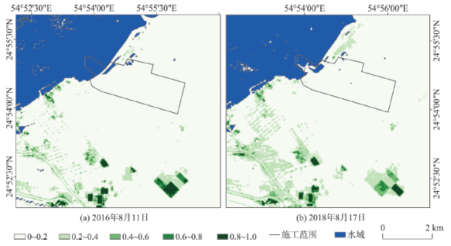
图3 2016—2018年迪拜哈翔项目周边植被覆盖度变化Fig. 3 Dynamic FVC changes around the Hassyan project in Dubai from 2016 to 2018 |
表4 2016—2018年迪拜哈翔项目植被覆盖变化情况Tab. 4 Changes of land vegetation cover of the Hassyan project in Dubai from 2016 to 2018 |
| 时间 | 覆盖度区间 | 0~0.2 | 0.2~0.4 | 0.4~0.6 | 0.6~0.8 | 0.8~1.0 |
|---|---|---|---|---|---|---|
| 2016-08-11 | 面积/km2 占比/% | 70.48 | 3.28 | 0.66 | 0.38 | 0.63 |
| 93.44 | 4.35 | 0.88 | 0.50 | 0.83 | ||
| 2018-08-17 | 面积/km2 占比/% | 67.90 | 6.01 | 0.94 | 0.38 | 0.40 |
| 89.78 | 7.95 | 1.24 | 0.50 | 0.53 |
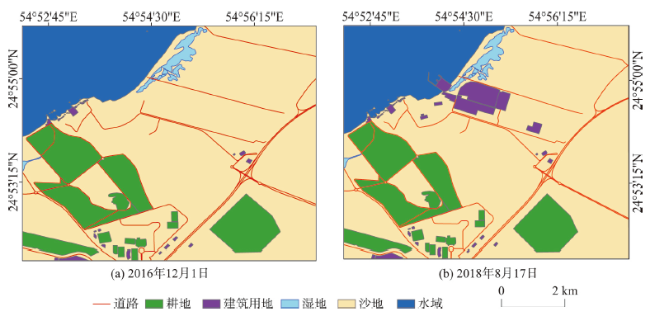
图4 2016—2018年迪拜哈翔项目土地覆被变化Fig. 4 Land cover changes of Hassyan project in Dubai from 2016 to 2018 |
表5 2016—2018年迪拜哈翔项目土地覆被类型转移矩阵Tab. 5 Land cover type transfer matrix of Hassyan project in Dubai from 2016 to 2018 (km2) |
| 2016年 | 2018年 | |||||
|---|---|---|---|---|---|---|
| 建筑用地面积 | 耕地 | 沙地 | 水域 | 湿地 | 总计 | |
| 建筑用地面积 | 0.3585 | 0 | 0 | 0 | 0 | 0.3585 |
| 耕地 | 0 | 8.5014 | 0 | 0 | 0 | 8.5014 |
| 沙地 | 1.4780 | 0 | 46.1817 | 0.0026 | 0 | 47.6623 |
| 水域 | 0.1246 | 0 | 0.0026 | 10.2367 | 0 | 10.3639 |
| 湿地 | 0.0604 | 0 | 0 | 0 | 0.6633 | 0.7238 |
| 总计 | 2.0215 | 8.5014 | 46.1843 | 10.2393 | 0.6633 | 67.6099 |
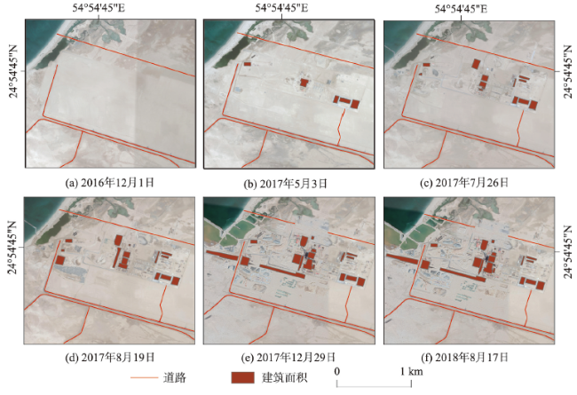
图6 2016—2018年迪拜哈翔项目道路长度和建筑面积变化Fig. 6 Changes of road length and building area of Hassyan project in Dubai from 2016 to 2018 |
表6 2016—2018年迪拜哈翔项目道路长度和建筑面积变化表Tab. 6 Changes of road length and building area of Hassyan project in Dubai from 2016 to 2018 |
| 2016-12-01 | 2017-05-03 | 2017-07-26 | 2017-08-19 | 2017-12-29 | 2018-08-17 | |
|---|---|---|---|---|---|---|
| 道路/km | 11.22 | 11.689 | 11.689 | 11.689 | 11.264 | 11.264 |
| 建筑面积/km2 | 0 | 0.034 | 0.06 | 0.088 | 0.14 | 0.14 |
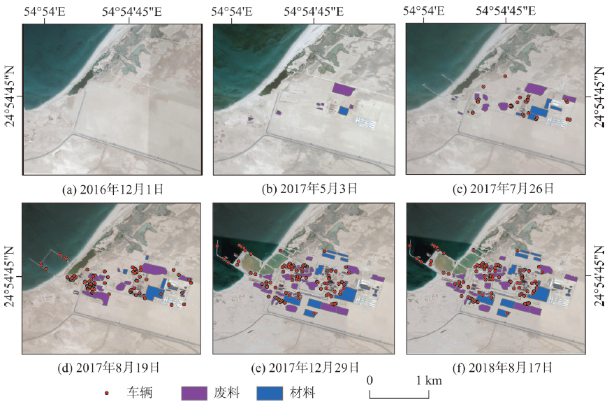
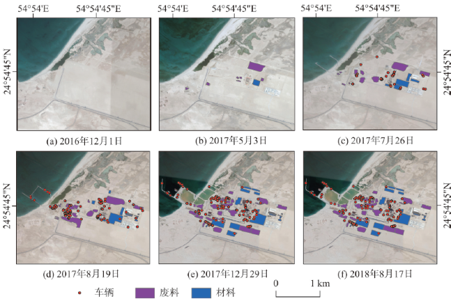
图8 2016—2018年迪拜哈翔项目工程进展情况Fig. 8 Project progress of Hassyan project in Dubai from 2016 to 2018 |
表7 2016—2018年迪拜哈翔项目工程进度监测Tab. 7 Project progress monitoring of Hassyan project in Dubai from 2016 to 2018 |
| 2016-12-01 | 2017-05-03 | 2017-07-26 | 2017-08-19 | 2017-12-29 | 2018-08-17 | |
|---|---|---|---|---|---|---|
| 车辆数量/辆 | 0 | 32 | 32 | 87 | 160 | 160 |
| 材料面积/km2 | 0 | 0.0164 | 0.0688 | 0.0828 | 0.1846 | 0.1846 |
| 废料面积/km2 | 0 | 0.0794 | 0.1011 | 0.1670 | 0.2182 | 0.2182 |
| [1] |
柳钦火, 吴俊君, 李丽, 等. “一带一路”区域可持续发展生态环境遥感监测[J]. 遥感学报, 2018,22(4):686-708.
[
|
| [2] |
潜旭明. “一带一路”倡议背景下中国的国际能源合作[J]. 国际观察, 2017(3):129-146.
[
|
| [3] |
|
| [4] |
|
| [5] |
李健锋, 叶虎平, 张宗科, 等. 基于Landsat影像的斯里兰卡内陆湖库水体时空变化分析[J]. 地球信息科学学报, 2019,21(5):781-788.
[
|
| [6] |
|
| [7] |
牛铮, 李加洪, 高志海, 等. 《全球生态环境遥感监测年度报告》进展与展望[J]. 遥感学报, 2018,22(4):672-685.
[
|
| [8] |
|
| [9] |
|
| [10] |
杨娟, 贾周云, 邵靖净. 基于BJ-1的环渤海区海岸工程变化遥感监测研究[J]. 科技与创新, 2016(9):12-13.
[
|
| [11] |
李序春, 徐惠民, 索安宁. 基于高空间分辨率遥感影像的港口区集约利用监测与评估——以渤海5个典型港区为例[J]. 应用海洋学学报, 2019,38(1):126-134.
[
|
| [12] |
|
| [13] |
|
| [14] |
|
| [15] |
|
| [16] |
|
| [17] |
|
| [18] |
刘广峰, 吴波, 范文义, 等. 基于像元二分模型的沙漠化地区植被覆盖度提取——以毛乌素沙地为例[J]. 水土保持研究, 2007(2):268-271.
[
|
| [19] |
|
| [20] |
陈晋, 陈云浩, 何春阳, 等. 基于土地覆盖分类的植被覆盖率估算亚像元模型与应用[J]. 遥感学报, 2001,5(6):416-422.
[
|
| [21] |
|
| [22] |
|
| [23] |
|
| [24] |
李苗苗, 吴炳方, 颜长珍, 等. 密云水库上游植被覆盖度的遥感估算[J]. 资源科学, 2004,26(4):153-159.
[
|
| [25] |
|
| [26] |
|
| [27] |
徐凯健, 田庆久, 杨闫君, 等. 遥感土地覆被分类的空间尺度响应研究[J]. 地球信息科学学报, 2018,20(2):246-253.
[
|
| [28] |
|
/
| 〈 |
|
〉 |