
基于SEVI的复杂地形山区植被FPAR遥感反演与地形效应评估
|
蒋世豪(1994— ),男,河南开封人,硕士生,研究方向为遥感技术与应用。E-mail:jzkkll@qq.com |
收稿日期: 2019-06-20
要求修回日期: 2019-10-31
网络出版日期: 2020-10-25
基金资助
国家重点研发计划课题(2017YFB0504203)
福建省自然科学基金项目(2017J01658)
版权
Vegetation FPAR Retrieval based on SEVI in Rugged Terrain and Terrain Effects Assessment
Received date: 2019-06-20
Request revised date: 2019-10-31
Online published: 2020-10-25
Supported by
National Key Research and Development Program of China(2017YFB0504203)
Natural Science Foundation of Fujian Province, China(2017J01658)
Copyright
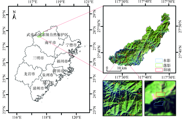
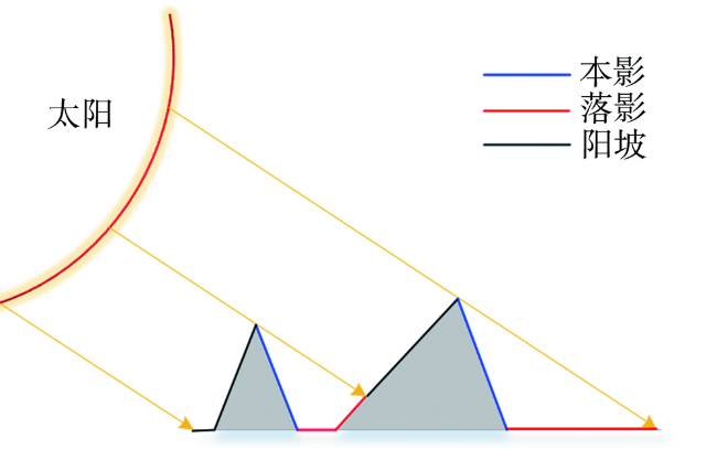
植物吸收性光合有效辐射分量(FPAR)的遥感反演是生态环境领域的核心研究内容之一,但在复杂地形山区,其估算精度严重受到地形效应的影响(包括本影与落影)。本文利用能够消除地形阴影影响的阴影消除植被指数(SEVI)对山区遥感影像进行FPAR反演,并分别与基于不同影像预处理程度计算的归一化植被指数(NDVI)、比值型植被指数(RVI)反演的FPAR做对比分析,以评估复杂山区反演FPAR存在的地形效应。结果表明:在不做地形校正的情况下,基于NDVI与RVI反演FPAR会使得本影及落影区域的值远小于非阴影区域的值,它们的相对误差均大于70%;基于C校正后的NDVI与RVI反演FPAR可以较好地校正本影区域,相对误差降至约6.974%,但落影处的校正效果不明显,相对误差约为48.133 %;而基于SEVI反演FPAR无需DEM数据的支持,可以达到经FLAASH+C组合校正后NDVI与RVI反演FPAR相似的结果,且能改善落影区域的地形校正效果,相对误差降至约2.730%。

蒋世豪 , 江洪 , 陈慧 . 基于SEVI的复杂地形山区植被FPAR遥感反演与地形效应评估[J]. 地球信息科学学报, 2020 , 22(8) : 1725 -1734 . DOI: 10.12082/dqxxkx.2020.190316
The retrival of Fraction of Absorbed Photosynthetically Active Radiation (FPAR) by remote sensing is one of the major research fields in ecological environment. However, in mountainous areas with rugged terrain, the estimation accuracy is seriously affected by terrain effect, including the influence of self and cast shadow. In this paper, Shadow-Eliminated Vegetation Index (SEVI), which can effectually remove the influence of terrain shadow, was used to conduct FPAR inversion in mountainous areas from remote sensing data. The inversion result based on SEVI was compared and analyzed with the inversion results based on Normalized Difference Vegetation Index (NDVI) and Ratio Vegetation Index (RVI) with different pre-processing degrees and evaluate the topographic effect of FPAR inversion based on different indexes in complex mountainous areas from remote sensing images. The results show that the FPAR inversion based on NDVI and RVI have much smaller values in self and cast shadow areas than that in non-shadow area without terrain correction using DEM data, their relative error are both greater than 70%. C correction can be better used in the pre-processing of NDVI and RVI deriving and effectually corrected the FPAR inversion results based on these two indexes, its relative error dropped to about 6.974%. But the results after C correction not performed well in cast shadow areas, its relative error is about 48.133%. The FPAR inversion based on the SEVI without DEM data can achieve similar results with the FPAR inversion based on NDVI and RVI after the atmospheric correction of the FLAASH and C combination, and the result shows a better terrain correction effect in shadow area where relative error dropped to about 2.730%.
Key words: FPAR; vegetation indices; SEVI; topographic correction; self shadow; cast shadow
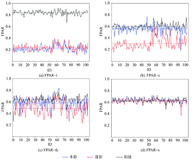
表1 FPAR在本影、落影、阳坡样本处的均值(M)以及相对误差(E)Tab. 1 Mean (M) and relative error (E) of vegetation indices in self shadows, cast shadows and sunny slopes |
| 结果 | 数据类别 | Mself | Mcast | Msunny | Mself /% | Mcast /% |
|---|---|---|---|---|---|---|
| FPAR-t | TOA | 0.217 | 0.240 | 0.838 | 74.046 | 71.340 |
| FPAR-c | C | 0.558 | 0.311 | 0.600 | 6.974 | 48.133 |
| FPAR-fc | FLAASH+C | 0.582 | 0.486 | 0.643 | 9.560 | 24.413 |
| FPAR-s | TOA | 0.634 | 0.619 | 0.637 | 0.382 | 2.730 |
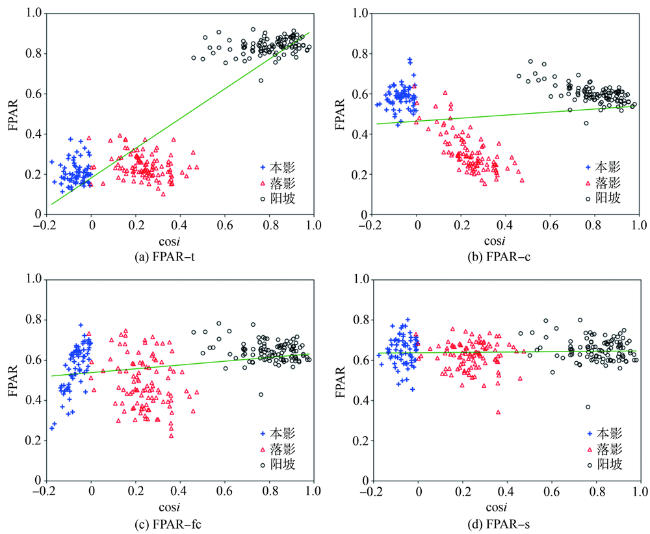
图6 104组样本的FPAR与cosi的散点图Fig. 6 Scatter plots of FPAR and cosi with 104 sets of samples |
表2 104组样本的线性相关分析以及变异系数(Std/Mean)Tab. 2 Linear correlation analysis and coefficient of variation (Std/Mean) of 104 sets of samples |
| 结果 | 数据类别 | r2 | k | d | Mean | Std | Std/Mean/% |
|---|---|---|---|---|---|---|---|
| FPAR-t | TOA | 0.830 | 1.123 | -0.146 | 0.432 | 0.292 | 67.627 |
| FPAR-c | C | 0.034 | 0.444 | 0.121 | 0.490 | 0.149 | 30.359 |
| FPAR-fc | FLAASH+C | 0.080 | 0.849 | -0.146 | 0.570 | 0.120 | 21.042 |
| FPAR-s | TOA | 0.002 | 0.396 | 0.089 | 0.630 | 0.039 | 6.202 |
注:r2、k、d分别为判定系数、斜率、截距。 |
| [1] |
|
| [2] |
|
| [3] |
Majasalmi, Titta, Rautiainen, et al. Modeled and measured FPAR in a boreal forest: Validation and application of a new model[J]. Agricultural & Forest Meteorology, 2014, 189-190(189-190):118-124.
|
| [4] |
|
| [5] |
|
| [6] |
|
| [7] |
周晓东, 朱启疆, 王锦地, 等. 夏玉米冠层内PAR截获及FPAR与LAI的关系[J]. 自然资源学报, 2002,17(1):110-116.
[
|
| [8] |
|
| [9] |
|
| [10] |
董恒, 何枋键, 张城芳. 基于辐射传输模型的FPAR_(green)与几种植被指数的关系研究[J]. 华中农业大学学报, 2016,35(4):70-75.
[
|
| [11] |
陈雪洋, 蒙继华, 吴炳方, 等. 基于HJ-1 CCD的夏玉米FPAR遥感监测模型[J]. 农业工程学报, 2010,26(S1):241-245.
[
|
| [12] |
董泰锋, 蒙继华, 吴炳方. 基于遥感的光合有效辐射吸收比率(FPAR)估算方法综述[J]. 生态学报, 2012,32(22):7190-7201.
[
|
| [13] |
吴炳方, 曾源, 黄进良. 遥感提取植物生理参数LAI/FPAR的研究进展与应用[J]. 地球科学进展, 2004,19(4):585-590.
[
|
| [14] |
江洪, 何国金, 黄海明, 等. 基于波段比模型的地形调节植被指数组合算法构建与验证[J]. 农业工程学报, 2017,33(5):156-161.
[
|
| [15] |
陈趁新, 胡昌苗, 霍连志, 等. Landsat TM数据不同辐射校正方法对土地覆盖遥感分类的影响[J]. 遥感学报, 2014,18(2):320-334.
[
|
| [16] |
孔金玲, 杨晶, 孙晓明, 等. 多光谱遥感影像大气校正与悬沙浓度反演——以曹妃甸近岸海域为例[J]. 国土资源遥感, 2016,28(3):130-137.
[
|
| [17] |
温素馨, 韦玉春, 汪美会. TM遥感图像FLAASH大气校正异常值的改正[J]. 测绘科学, 2017,42(7):165-171.
[
|
| [18] |
陈建珍, 何超, 寇卫利. 高山峡谷地区遥感图像地形校正[J]. 山地学报, 2016,34(5):623-631.
[
|
| [19] |
|
| [20] |
廖钰冰, 陈新芳, 陈喜, 等. 地形校正对叶面积指数遥感估算的影响[J]. 遥感信息, 2011(5):47-51.
[
|
| [21] |
王飒, 李熙, 张奇, 等. Landsat影像地形校正方法的适用性分析[J]. 华中师范大学学报(自然科学版), 2013,47(4):571-577.
[
|
| [22] |
林起楠, 黄华国, 陈玲, 等. 陡峭山区影像的半经验地形校正[J]. 遥感学报, 2017(5):776-784.
[
|
| [23] |
吴志杰, 何国金, 黄绍霖, 等. 南方丘陵区植被覆盖度遥感估算的地形效应评估[J]. 遥感学报, 2017,20(1):159-167.
[
|
| [24] |
吴志杰, 何国金, 王猛猛, 等. 南方丘陵区植被覆盖度遥感估算与时空变化研究——以福建省永定县为例[J]. 遥感技术与应用, 2016,31(6):1201-1208.
[
|
| [25] |
|
| [26] |
管小彬, 沈焕锋, 甘文霞, 等. 基于Landsat TM/ETM+影像的武汉市冬季NPP估算及其时空变化分析[J]. 遥感技术与应用, 2015,30(5):884-890.
[
|
| [27] |
尹锴, 田亦陈, 袁超, 等. 基于CASA模型的北京植被NPP时空格局及其因子解释[J]. 国土资源遥感, 2015,27(1):133-139.
[
|
| [28] |
张时煌, 彭公炳, 黄玫. 基于遥感与地理信息系统支持下的地表植被特征参数反演[J]. 气候与环境研究, 2004,9(1):80-91.
[
|
| [29] |
袁烨城, 李宝林, 王双, 等. 基于GF-1/WFV数据的三江源草地月度NPP反演研究[J]. 地球信息科学学报, 2018,20(12):1799-1809.
[
|
| [30] |
|
| [31] |
江洪, 张兆明, 汪小钦, 等. 基于TAVI的山区毛竹林LAI反演分析[J]. 地球信息科学学报, 2015,17(4):500-504.
[
|
| [32] |
张兆明, 何国金, 刘定生, 等. 一种改进的遥感影像地形校正物理模型[J]. 光谱学与光谱分析, 2010,30(7):1839-1842.
[
|
| [33] |
徐希孺, 范闻捷, 李举材, 等. 植被二向性反射统一模型[J]. 中国科学(地球科学), 2017,47(2):217-232.
[
|
| [34] |
于颖, 范文义, 杨曦光. 三种植被冠层二向反射分布函数模型的比较[J]. 植物生态学报, 2012,36(1):55-62.
[
|
/
| 〈 |
|
〉 |

