
三江源区毒杂草型退化草地植被光谱特征分析
|
周 伟(1984— ),女,山东泰安人,副教授,博士,主要从事生态环境遥感监测和3S技术集成研究。E-mail:zhouw @lreis.ac.cn |
收稿日期: 2019-10-16
要求修回日期: 2020-01-16
网络出版日期: 2020-10-25
基金资助
重庆市教委科学技术研究项目(KJQN201800702)
中国博士后基金项目(2019M650821)
重庆市技术创新与应用发展专项重点项目子课题(cstc2019jscx-fxyd0236)
国家自然科学基金项目(41501575)
版权
Spectral Characteristics of Vegetation of Poisonous Weed Degraded Grassland in the "Three-River Headwaters" Region
Received date: 2019-10-16
Request revised date: 2020-01-16
Online published: 2020-10-25
Supported by
Scientific and Technological Research Program of Chongqing Municipal Education Commission(KJQN201800702)
Sub Project of Chongqing Technology Innovation and Appliacation Development Special Key Project(2019M650821)
National Science Foundation for Post- doctoral Scientists of China(cstc2019jscx-fxyd0236)
National Natural Science Foundation of China(41501575)
Copyright
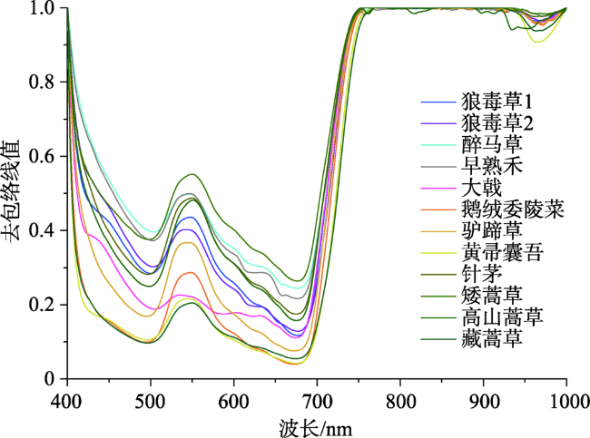
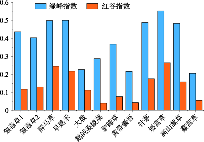
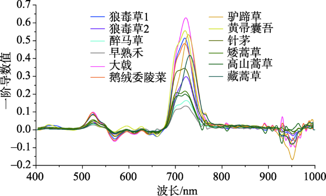
毒草型退化草地具有群落演替特点,通过高光谱遥感技术反演毒杂草分布与退化草地群落结构能对该类退化草地进行有效监测,而光谱特征分析是毒杂草与优良牧草遥感识别的基础。本文选取了三江源区毒草型退化草地的8种典型毒杂草和4种优良牧草的地面实测高光谱数据作为研究样本,经过SG平滑、包络线去除、导数变换和光谱参量化对毒杂草种和优良牧草种的光谱特征进行了分析,并通过马氏距离法提取其特征识别波段。结果表明:① 8种典型毒杂草和4种优良牧草的 “近红外峰值”差异较大,其中鹅绒萎陵菜的“近红外峰值”达到60.07%,而最小者早熟禾仅为17.53%;② 经包络线去除处理后,植被光谱曲线中吸收谷和反射峰光谱差异更加明显,且可减少环境背景对植被光谱的影响,如沼泽草甸的鹅绒委陵菜和驴蹄草,其“绿峰幅值”分别为6.46%和6.89%,经处理后其“绿峰指数”分别为0.2866和0.3671,而在2种环境下生长的同一草种(狼毒草1和狼毒草2)的峰谷特征差异不明显;③ 基于马氏距离法提取的毒杂草与优良牧草的敏感识别波段主要分布在680~750 nm和900~1000 nm波长范围内,以醉马草与矮嵩草为例,其基于反射率的敏感识别波段为713.1~737.1 nm和934.6~965.6 nm。该研究可为利用高光谱遥感进行大面积毒杂草草种识别和植被群落生长监测提供重要科学依据,对于三江源区毒杂草的监测防治和畜牧业的可持续发展具有重要意义。

周伟 , 李浩然 , 石佩琪 , 谢利娟 , 杨晗 . 三江源区毒杂草型退化草地植被光谱特征分析[J]. 地球信息科学学报, 2020 , 22(8) : 1735 -1742 . DOI: 10.12082/dqxxkx.2020.190606
The poisonous weed type degraded grassland is a type of degraded grassland in the "Three-River Headwaters" Region, which has the characteristics of community reverse succession. Its manifestation is that the grassland community with fine herbage as the dominant species evolved into the grassland community with weeds and poisonous plants as the dominant species. Therefore, the key to control this kind of grassland degradation is to monitor the spread of poisonous weeds and the change of grassland community structure. Hyperspectral remote sensing Technology can be used to identify poisonous weeds and fine herbage in a region, and spectual feature analysis is the basis of remote sensing recognition of terrain features. In this paper, the hyperspectral data of eight typical poisonous weeds and four fine herbages in the degraded grassland of toxic weed type in the Three-River Headwaters Region were selected as the research samples. The hyperspectral data in this study are all from field sampling using AvaField-2 portable hyperspectral surface object spectrometer. After Savitzky-Golay convolution smoothing, envelope removal, derivative transformation, and spectral parameterization, the spectral characteristics of poisonous weeds and fine forage species were analyzed, and the characteristic recognition bands were extracted by Mahalanobis distance method. The results showed that: (1) After data preprocessing, the spectral reflectance curves of eight poisonous weeds and four fine forages are similar, but the spectral reflectance differences can be compared through some characteristic bands and parameters; (2) NIR peak refers to the maximum reflectivity of each vegetation in the wavelength range 780~1000 nm. The NIR peak of eight typical poisonous weeds and four fine forages were significantly different. The NIR peak of Potentilla anserine reached 60.07%, while that of Poa pratensis was only 17.53%; (3) After envelope removal, the spectral difference between absorption valley and reflection peak in vegetation spectral curve is more obvious. The maximum values of Caltha and Ligulariavirgaurea with similar NIR peaks were 0.3671 and 0.2157, respectively, in the green band; (4) The sensitive recognition bands of toxic weeds and fine forages based on Mahalanobis distance are mainly distributed in the wavelength range of 680~750 nm and 900~1000 nm. This study can provide an important scientific basis for the use of hyperspectral remote sensing in the identification of large-area poisonous weeds and the monitoring of vegetation community growth. It is of great significance to the monitoring and control of poisonous weeds and the sustainable development of animal husbandry in the Three-River Headwaters Region.
表1 样地信息Tab. 1 Sample plot information |
| 样地编号 | 样地位置 | 海拔/m | 草地类型 | 盖度/% | 优良牧草(相对盖度/%) | 典型毒杂草(相对盖度/%) |
|---|---|---|---|---|---|---|
| 样地1 | 同德县北巴滩乡 | 3318 | 温性草原 | 68 | 矮嵩草(22.70) | 醉马草(3.60)、早熟禾(3.12)、狼毒草1 (3.42) |
| 样地2 | 泽库县王家乡 | 3376 | 高寒草原 | 70 | 针茅(40.91) | 狼毒草2 (6.56) |
| 样地3 | 称多县清水河镇 | 4419 | 高寒草甸 | 85 | 高山嵩草(29.5) | 大戟(7.97) |
| 样地4 | 玉树县隆宝自然保护区 | 4212 | 沼泽草甸 | 100 | 藏嵩草(37.45) | 鹅绒委陵菜(26.22)、驴蹄草(8.99)、黄帚橐吾(7.49) |
注:狼毒草1为温性草原所测的狼毒草样本,狼毒草2为高寒草原所测样本,二者均为同一草种。 |
图2 三江源区8种典型毒杂草与4种优良牧草的光谱反射率曲线Fig. 2 Spectral reflectance curveof 8 typical poisonous weeds and 4 fine forages in the "Three-River Headwaters" Region |
表2 三江源区8种典型毒杂草与4种优良牧草的植被反射率光谱特征参数Tab. 2 Spectral characteristic parameters of vegetation reflectance of 8 typical poisonous weeds and 4 fine forages in the "Three-River Headwaters" Region (%) |
| 草地类型 | 植被样本 | 绿峰幅值 | 红谷反射率 | 近红外峰值 |
|---|---|---|---|---|
| 温性草原 | 矮嵩草 | 7.94 | 4.89 | 43.91 |
| 狼毒草1 | 4.72 | 2.63 | 29.48 | |
| 醉马草 | 4.16 | 3.39 | 22.60 | |
| 早熟禾 | 3.28 | 2.38 | 17.53 | |
| 高寒草原 | 针茅 | 6.35 | 5.17 | 30.91 |
| 狼毒草2 | 8.81 | 4.14 | 48.79 | |
| 高寒草甸 | 高山嵩草 | 4.52 | 2.53 | 25.03 |
| 大戟 | 5.08 | 4.48 | 59.63 | |
| 沼泽草甸 | 藏嵩草 | 2.97 | 1.41 | 40.68 |
| 鹅绒委陵菜 | 6.46 | 1.58 | 60.07 | |
| 驴蹄草 | 6.89 | 2.48 | 49.50 | |
| 黄帚橐吾 | 3.82 | 1.34 | 47.72 |
表3 三江源区8种典型毒杂草与4种优良牧草的 “红边”光谱特征参数Tab. 3 "Red Edge" spectral characteristic parameters of 8 typical poisonous weeds and 4 fine forages in the “Three-River Headwaters” Region |
| 草地类型 | 植被样本 | 红边幅值 | 红边位置/nm | 红边面积 |
|---|---|---|---|---|
| 温性草原 | 矮嵩草 | 0.2169 | 720.5 | 17.52 |
| 狼毒草1 | 0.5145 | 720.0 | 37.10 | |
| 醉马草 | 0.1644 | 723.3 | 12.87 | |
| 早熟禾 | 0.1333 | 721.7 | 10.50 | |
| 高寒草原 | 针茅 | 0.3452 | 719.3 | 27.48 |
| 狼毒草2 | 0.2981 | 722.8 | 21.40 | |
| 高寒草甸 | 高山嵩草 | 0.2002 | 720.5 | 16.06 |
| 大戟 | 0.6280 | 722.2 | 46.23 | |
| 沼泽草甸 | 藏嵩草 | 0.4182 | 730.8 | 28.20 |
| 鹅绒委陵菜 | 0.4839 | 719.3 | 36.45 | |
| 驴蹄草 | 0.5335 | 727.9 | 35.95 | |
| 黄帚橐吾 | 0.5559 | 720.5 | 42.30 |
表4 三江源区8种典型毒杂草与4种优良牧草的敏感识别波段Tab. 4 Sensitive identification bands of 8 typical poisonous weeds and 4 fine forages in the "Three-River Headwaters" Region |
| 草地类型 | 识别植被 | 基于光谱反射率的敏感识别波段/nm | 基于一阶导数的敏感识别波段/nm |
|---|---|---|---|
| 温性草原 | 狼毒草1—矮嵩草 | 695.9~718.2、988.2~1000.0 | 686.1~745.0 |
| 醉马草—矮嵩草 | 713.1~737.1、934.6~965.6 | 689.6~743.3 | |
| 早熟禾—矮嵩草 | 713.1~727.9、988.2~1000.0 | 695.3~739.9 | |
| 高寒草原 | 狼毒草2—针茅 | 734.8~786.5、945.7~1000.0 | 687.9~738.8 |
| 高寒草甸 | 大戟—高山嵩草 | 543.2~573.9、971.7~1000.0 | 689.6~739.9、924.6~932.5 |
| 沼泽草甸 | 鹅绒委陵菜—藏嵩草 | 706.8~753.6 | 693.0~752.9 |
| 驴蹄草—藏嵩草 | 702.8~749.7、879.4~890.1 | 708.5~754.7、946.2~956.7 | |
| 黄帚橐吾—藏嵩草 | 734.2~743.8、951.8~1000.0 | 695.3~739.9 |
| [1] |
徐新良, 王靓, 李静, 等. 三江源生态工程实施以来草地恢复态势及现状分析[J]. 地球信息科学学报, 2017,19(1):50-58.
[
|
| [2] |
李穗英, 刘峰贵, 马玉成, 等. 三江源地区草地退化现状及原因探讨[J]. 青海农林科技, 2007(4):29-32.
[
|
| [3] |
赵成章, 樊胜岳, 殷翠琴, 等. 毒杂草型退化草地植被群落特征的研究[J]. 中国沙漠, 2004,24(4):507-512.
[
|
| [4] |
公延明, 胡玉昆, 阿德力 .麦地, 等. 巴音布鲁克高寒草地退化演替阶段植物群落特性研究[J]. 干旱区资源与环境, 2010,24(6):151-154.
[
|
| [5] |
周家福, 干友民, 李志丹, 等. 川西北高寒草地退化演替群落的数量分类与排序[J]. 湖北农业科学, 2008,47(2):92-95.
[
|
| [6] |
张静, 李希来, 王金山, 等. 三江源地区不同退化程度草地群落结构特征的变化[J]. 湖北农业科学, 2009,48(9):2125-2129.
[
|
| [7] |
|
| [8] |
|
| [9] |
安如, 姜丹萍, 李晓雪, 等. 基于地面实测高光谱数据的三江源中东部草地植被光谱特征研究[J]. 遥感技术与应用, 2014,29(2):202-211.
[
|
| [10] |
李双. 基于高光谱数据的三江源退化草地杂类草遥感分类研究[D]. 北京:中国科学院地理科学与资源研究所, 2014.
[
|
| [11] |
喻小勇, 邵全琴, 刘纪远, 等. 三江源区不同退化程度的高寒草甸光谱特征分析[J]. 地球信息科学学报, 2012,14(3):398-404.
[
|
| [12] |
王堃, 洪绂曾, 宗锦耀. “三江源”地区草地资源现状及持续利用途径[J]. 草地学报, 2005,13(S1):28-31.
[
|
| [13] |
刘纪远, 徐新良, 邵全琴. 近30年来青海三江源地区草地退化的时空特征[J]. 地理学报, 2008,63(4):364-376.
[
|
| [14] |
蔡天净, 唐瀚. Savitzky-Golay平滑滤波器的最小二乘拟合原理综述[J]. 数字通信, 2011(1):63-68.
[
|
| [15] |
徐元进, 胡光道, 张振飞. 包络线消除法及其在野外光谱分类中的应用[J]. 地理与地理信息科学, 2005,21(6):11-14.
[
|
| [16] |
李志刚. 光谱数据处理与定量分析技术[M]. 北京: 北京邮电大学出版社, 2017.
[
|
| [17] |
温阿敏, 郑江华, 穆晨, 等. 新疆草原毒草白喉乌头高光谱特征提取与分析研究[J]. 中国植保导刊, 2015,35(3):5-11.
[
|
| [18] |
闻兵工, 杨秀策, 常悦. 一种高光谱影像包络线消除的新方法[J]. 测绘科学与工程, 2010(4):7-9.
[
|
/
| 〈 |
|
〉 |

