
GF-2在城市绿地分类及景观格局度量中的应用
|
汪雪淼(1998— ),女,四川成都人,硕士生,主要从事城市环境遥感研究。E-mail:xuemiao98@163.com |
收稿日期: 2020-03-16
要求修回日期: 2020-07-03
网络出版日期: 2020-12-25
基金资助
国家重点研发计划项目(2017YFB0503905)
四川省科技计划项目(2018JZ0054)
国家高分辨率对地观测重大科技专项项目“环境保护遥感动态监测信息服务系统(二期05-Y30B01-9001-19/20-1)
版权
Urban Green Space Classification and Landscape Pattern Measurement based onGF-2 Image
Received date: 2020-03-16
Request revised date: 2020-07-03
Online published: 2020-12-25
Supported by
The National Key Research and Development Program(2017YFB0503905)
Sichuan Province Science and Technology Program(2018JZ0054)
The Major Projects of High Resolution Earth Observation Systems of National Science and Technology(二期05-Y30B01-9001-19/20-1)
Copyright
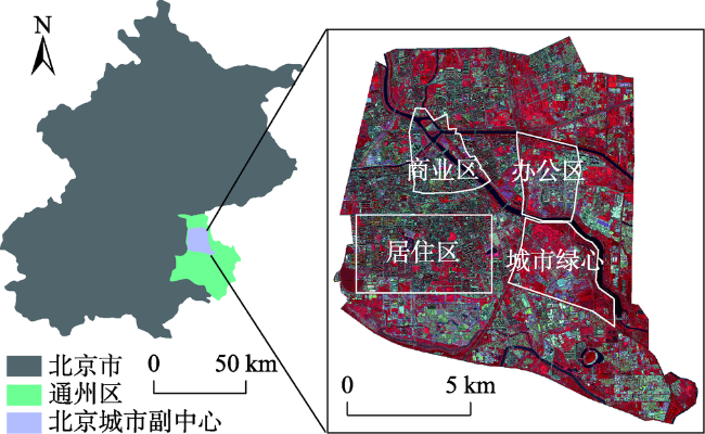
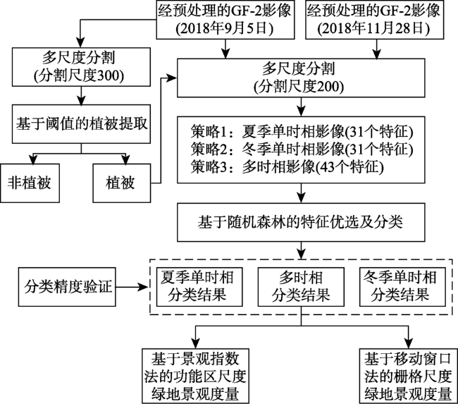
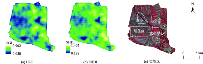
城市植被是维护城市生态系统平衡的重要组成元素,不同类型的植被具有不同的生态服务效益,然而基于植被精细分类的城市绿地景观格局度量研究较少。因此本文以北京城市副中心为研究区,使用夏、冬两季GF-2卫星遥感影像,基于随机森林特征优选和面向对象分类,划分了植被类型,并在此基础上使用景观指数法和移动窗口法分别度量了功能区尺度和栅格尺度绿地景观特征。研究结果表明:针对GF-2数据,使用多尺度分割后影像对象的光谱、纹理特征可以有效地提取植被信息;不同时相的影像能反映各类型植被的物候特征,相比于单时相数据,其分类精度更高,达到了87.7%;各功能区绿地景观格局特征差异较大,城市绿心拥有最丰富的植被且分布集中,商业区植被覆盖度和多样性均较低,绿地景观破碎;北京城市副中心景观多样性及各类型植被分布特征的空间差异显著,当前副中心绿地景观格局已形成规划的基本轮廓,但城市绿心和老城区公共绿地的建设仍有不足。研究探明了北京城市副中心绿地建设现状,证明了国产GF-2卫星在城市生态环境监测中具有较高的应用价值,有助于推动GF-2在城市生态环境领域的应用,并为副中心建设中的绿地系统监测和优化提供参考。
汪雪淼 , 孟庆岩 , 赵少华 , 李娟 , 张琳琳 , 陈旭 . GF-2在城市绿地分类及景观格局度量中的应用[J]. 地球信息科学学报, 2020 , 22(10) : 1971 -1982 . DOI: 10.12082/dqxxkx.2020.200122
Urban vegetation is an important component of an urban ecosystem, which provides important ecological service including purifying urban air, regulating urban climate, and beautifying urban landscape. Different types of vegetation provide different ecological service. To date, there have been many studies on characterizing urban green space landscape pattern and analyzing its spatiotemporal dynamics. However, the green space landscape patterns of different vegetation types have not been well quantified. In this study, we took Beijing Vice-City Center as the study area and focused on different types of urban vegetation (broad-leaved trees, conifers, farmland, grasslands, and shrublands). Due to the small size of urban vegetation patches and their high spatial heterogeneity, the object-oriented classification method was adopted in this study. Specifically, the image objects using multi-resolution segmentation were generated first. Then, combing the field sampling data, we applied random forest in feature selection and classification using GF-2 images in summer and winter. Based on the classified vegetation map with detailed information, landscape metrics and moving window approach were used to quantify the landscape pattern of urban green space at functional scale and grid scale, respectively. Our results show that, for GF-2 images, the spectral and textural features of image objects after multi-resolution segmentation can effectively improve the extraction of different vegetation types. Multi-temporal images can also provide phenological information of different vegetation types. Compared with the classification results using either summer images or winter images, our classification accuracy was improved to 87.7%. In our study area, the fragmentation of shrublands was the highest. The area proportion of conifers was the smallest, but its patch shape was the most complex. While the distribution of broad-leaved trees, grasslands, and farmland was spatially centralized and contiguous with a regular shape. We found that the green space landscape pattern in different functional areas were quite different. The urban green center had the most abundant vegetation. While the commercial area had less green space that was also fragmentized. The landscape diversity and the distribution of different vegetation types showed a spatial heterogeneity in the Beijing Vice-City Center. At present, the landscape pattern of green space in Beijing Vice-City Center has formed the basic outline of planning, but the construction of urban green center and the public green space in city center are still insufficient. Our study evaluates the current situation of green space patten in Beijing Vice-City Center and proves that GF-2 can be applied in urban ecological environment monitoring, which provides a useful reference for the future monitoring and optimization of urban green space.
表1 使用不同特征个数的总体分类精度Tab. 1 Overall classification accuracy obtained by using different number of features (%) |
| 特征个数 | 夏季单时相 | 冬季单时相 | 多时相 |
|---|---|---|---|
| 5 | 72.4 | 54.0 | 74.4 |
| 10 | 72.6 | 58.8 | 85.7 |
| 15 | 77.5 | 59.3 | 87.0 |
| 20 | 77.5 | 61.7 | 87.7 |
| 25 | 77.5 | 62.1 | 87.2 |
| 30 | 78.3 | 63.4 | 87.0 |
| 35 | - | - | 85.7 |
| 40 | - | - | 87.0 |
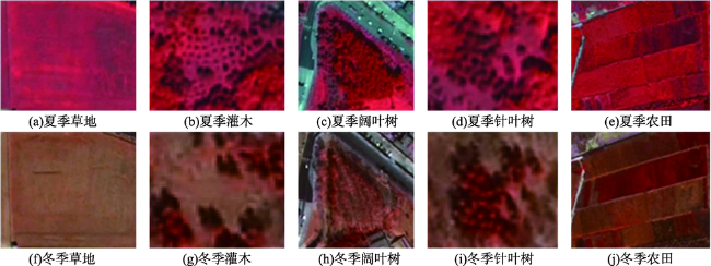
图7 2018年北京城市副中心城市植被类型Fig. 7 Urban vegetation classification map of Beijing Vice-City Center in 2018 |
表2 利用3种影像进行城市植被分类的精度Tab. 2 Classification accuracy of urban vegetation classif-ication using summer, winter and multi-temporal image |
| 夏季 | 冬季 | 多时相 | ||||||
|---|---|---|---|---|---|---|---|---|
| PA | UA | PA | UA | PA | UA | |||
| 阔叶树 | 0.74 | 0.80 | 0.65 | 0.49 | 0.89 | 0.89 | ||
| 针叶树 | 0.73 | 0.81 | 0.94 | 0.76 | 0.90 | 0.92 | ||
| 农田 | 0.63 | 0.68 | 0.76 | 0.60 | 0.69 | 0.82 | ||
| 草地 | 0.92 | 0.86 | 0.62 | 0.79 | 0.93 | 0.88 | ||
| 灌木 | 0.90 | 0.75 | 0.14 | 0.50 | 0.97 | 0.86 | ||
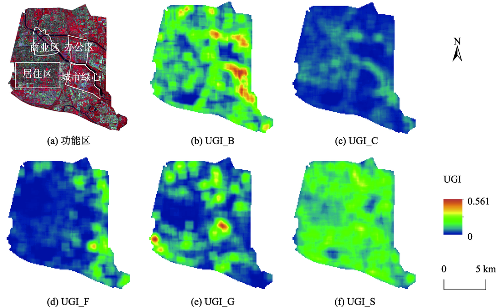
表3 2018年北京城市副中心绿地景观指数计算结果(景观水平)Tab. 3 Calculation results of green space landscape metrics of Beijing Vice-City Center in 2018 (landscape level) |
| PLAND/% | PD/(个/100ha) | ED/(m/ha) | FRAC | SHDI | AI | |
|---|---|---|---|---|---|---|
| 城市绿心 | 65.012 | 677.050 | 701.849 | 1.252 | 1.504 | 95.395 |
| 居住区 | 38.098 | 1612.312 | 689.839 | 1.249 | 1.415 | 93.600 |
| 办公区 | 37.060 | 784.271 | 668.851 | 1.250 | 1.396 | 95.096 |
| 商业区 | 26.907 | 1833.961 | 720.051 | 1.251 | 1.331 | 93.364 |
| 研究区 | 43.805 | 1008.982 | 673.226 | 1.252 | 1.485 | 94.758 |
| [1] |
孟雪松, 欧阳志云, 崔国发 等. 北京城市生态系统植物种类构成及其分布特征[J]. 生态学报, 2004,24(10):2200-2206.
[
|
| [2] |
杨士弘. 城市绿化树木的降温增湿效应研究[J]. 地理研究, 1994,13(4):74-80.
[
|
| [3] |
|
| [4] |
王成. 城镇不同类型绿地生态功能的对比分析[J]. 东北林业大学学报, 2002,30(3):111-114.
[
|
| [5] |
|
| [6] |
魏绪英, 蔡军火, 叶英聪, 等. 基于GIS的南昌市公园绿地景观格局分析与优化设计[J]. 应用生态学报, 2018,29(9):2852-2860.
[
|
| [7] |
汝绪伟, 江涛. 城市绿地演化驱动因素与景观格局空间分析——以济南市建成区为例[J]. 水土保持研究, 2015,22(5):197-203.
[
|
| [8] |
雷一鸣, 陈曦, 杨辽, 等. 基于Worldview-2的乌鲁木齐城区绿地空间格局分析[J]. 干旱区研究, 2015,32(6):1233-1239.
[
|
| [9] |
|
| [10] |
|
| [11] |
付凤杰, 刘珍环, 黄千杜. 深圳市福田区三维城市景观格局变化特征[J]. 生态学报, 2019,39(12):4299-4308.
[
|
| [12] |
|
| [13] |
|
| [14] |
陈永生, 徐小牛. 基于RS和GIS的合肥市城市绿地景观空间结构的分析评价[J]. 东北林业大学学报, 2012,40(3):62-66.
[
|
| [15] |
阳文锐. 北京城市景观格局时空变化及驱动力[J]. 生态学报, 2015,35(13):4357-4366.
[
|
| [16] |
谭丽, 何兴元, 陈玮, 等. 基于QuickBird卫星影像的沈阳城市绿地景观格局梯度分析[J]. 生态学杂志, 2008,27(7):1141-1148.
[
|
| [17] |
|
| [18] |
|
| [19] |
|
| [20] |
郑利娟. 基于高分一/六号卫星影像特征的农作物分类研究[D]. 北京:中国科学院遥感与数字地球研究所, 2017.
[
|
| [21] |
贾明明, 任春颖, 刘殿伟, 等. 基于环境星与MODIS时序数据的面向对象森林植被分类[J]. 生态学报, 2014,34(24):7167-7174.
[
|
| [22] |
刘怀鹏. 基于WorldView-2数据的城市典型绿化树种分类[D]. 呼和浩特:内蒙古农业大学, 2016.
[
|
| [23] |
|
| [24] |
|
| [25] |
|
| [26] |
|
| [27] |
北京市规划和自然资源委员会. 北京城市副中心控制性详细规划(街区层面)(2016—2035年)规划图纸[EB/OL]. http://ghzrzyw.beijing.gov.cn/zhengwuxinxi/ghcg/csfzxgh/201912/t20191213_1165346. html, 2019-01-04.
[ Beijing Municipal Commission of Planning and Natural Resources. Regulatory detailed planning of Beijing Sub Center (block level) (2016-2035)[EB/OL]. http://ghzrzyw.beijing.gov.cn/zhengwuxinxi/ghcg/csfzxgh/201912/t20191213_1165346. html, 2019-01-04.]
|
| [28] |
中国资源卫星应用中心. 高分二号[EB/OL]. http://www.cresda.com/CN/Satellite/3128.shtml, 2015-10-15.
[ China Centre For Resources Satellite Data and Application. GF-2[EB/OL]. http://www.cresda.com/CN/Satellite/3128.shtml, 2015-10-15.]
|
| [29] |
|
| [30] |
任芯雨. 考虑植被季相节律的高分辨率遥感影像城市森林分类[D]. 南京:南京林业大学, 2016.
[
|
| [31] |
张秀英, 冯学智, 江洪. 面向对象分类的特征空间优化[J]. 遥感学报, 2009,13(4):664-669.
[
|
| [32] |
|
| [33] |
|
| [34] |
李秀珍, 布仁仓, 常禹, 等. 景观格局指标对不同景观格局的反应[J]. 生态学报, 2004,24(1):123-134.
[
|
| [35] |
吴俊, 孟庆岩, 占玉林, 等. 一种基于移动窗口的城市绿度遥感度量方法[J]. 地球信息科学学报, 2016,18(4):544-552.
[
|
| [36] |
孟庆岩. 城市绿度空间遥感[M]. 北京: 科学出版社, 2020: 51-68.
[
|
| [37] |
黄晶. 基于分形维度与灰度共生矩阵的图像分类研究[D]. 武汉:武汉理工大学, 2008.
[
|
| [38] |
李哲, 张沁雨, 邱新彩, 等. 基于高分二号遥感影像树种分类的时相及方法选择[J]. 应用生态学报, 2019,30(12):4059-4070.
[ LiZ,
|
/
| 〈 |
|
〉 |


