
结合像元级与对象级的滨海湿地变化检测方法
|
吴瑞娟(1985— ),女,山西河津人,博士,讲师,主要从事3S技术集成与应用研究。E-mail:rjwu@njtc.edu.cn |
收稿日期: 2019-08-01
要求修回日期: 2019-09-20
网络出版日期: 2020-12-25
基金资助
国家自然科学基金项目(41830110)
国家自然科学基金项目(41871203)
内江师范学院科研资助项目(2019YZ02)
版权
Coastal Wetlands Change Detection Combining Pixel-based and Object-based Methods
Received date: 2019-08-01
Request revised date: 2019-09-20
Online published: 2020-12-25
Supported by
National Natural Science Foundation of China(41830110)
National Natural Science Foundation of China(41871203)
Research Funding Project of Neijiang Normal University(2019YZ02)
Copyright
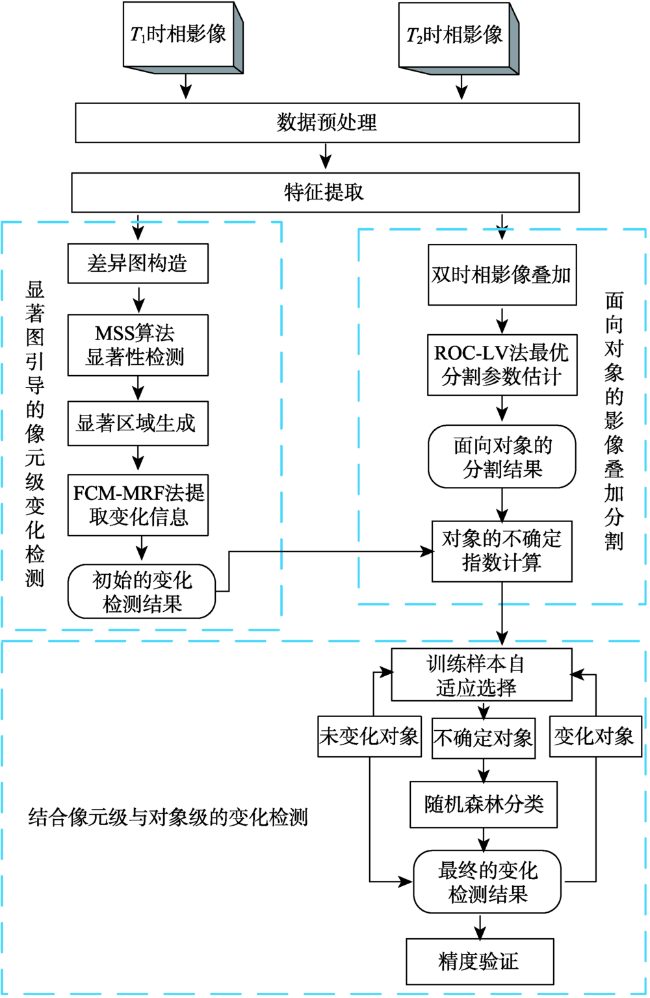
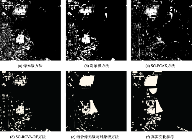
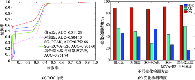
滨海湿地是动态且脆弱的生态系统,遥感变化检测技术为滨海湿地动态变化监测提供了有效手段。为解决像元级变化检测对配准误差敏感及其椒盐现象严重,对象级变化检测受分割参数影响较大且过程繁琐等问题,本文提出了显著图引导的结合像元级与对象级变化检测方法。首先,提取湿地亮度、归一化差异植被指数、归一化差异水体指数三个特征,得到特征差异影像;其次,利用最大对称环绕显著性检测算法生成显著图,采用结合模糊C均值和马尔可夫随机场方法对显著区域进行分割得到初始像元级变化检测结果;最后,在面向对象分割的基础上,通过构建对象的不确定性指数自适应选择训练样本,采用随机森林分类器进行分类得到最终变化检测结果。利用江苏盐城滨海湿地资源三号影像进行实验,结果表明,结合像元级与对象级方法的湿地变化检测总体精度为93.51%,与像元级、对象级方法相比,虚检率分别降低了29.04%和22.78%。

吴瑞娟 , 何秀凤 , 王静 . 结合像元级与对象级的滨海湿地变化检测方法[J]. 地球信息科学学报, 2020 , 22(10) : 2078 -2087 . DOI: 10.12082/dqxxkx.2020.190417
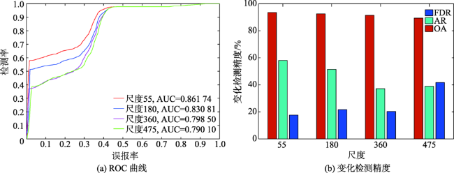
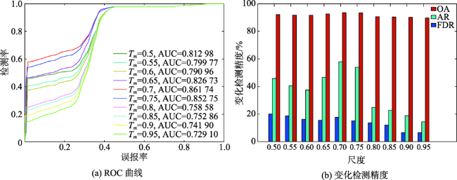
Coastal wetlands are dynamic and fragile ecosystems, and they have taken place obvious changes, which affected by siltation and erosion, coastal development and utilization, therefore it is of great practical significance to timely monitor coastal wetlands changes. Remote sensing change detection technology can obtain the changes occurred in different times by mathematical model analysis, so it provides an effective way to monitor the dynamic changes of coastal wetlands. From the perspective of analysis unit of remote sensing change detection technology, change detection methods can be divided into pixel-based change detection methods and object-based change detection methods. Pixel-based change detection methods are sensitive to image registration errors, and their salt-and-pepper phenomena are also serious, while object-based methods are affected by image segmentation parameters, and often complicated for users. In order to solve the problems above, saliency-guided change detection combining pixel-based and object-based methods is proposed, in which the scene characteristics of coastal wetlands are taken into account. Firstly, the brightness, Normalized Difference Vegetation Index (NDVI) and Normalized Difference Water Index (NDWI) features are extracted, and the feature difference images are then obtained. Secondly, the Maximum Symmetric Surround (MSS) saliency detection algorithm is used to generate the saliency maps of feature difference images, and then the combination of Fuzzy C-means (FCM) with Markov Random Field (MRF) is used to extract the initial change detection result at the pixel level. Finally, multi-scale segmentation algorithm is utilized for object-oriented image segmentation, in which Rate of Change of Local Variance (ROC-LV) is used to estimate the optimal segmentation scales. The uncertainty index of segmentation objects is constructed to adaptively select training samples, and these training samples are used to train random forest classifier which is used to obtain the final change detection results. The experiments are carried out using Ziyuan-3 images in Yancheng coastal wetlands, Jiangsu Province, the results show that the proposed saliency-guided change detection combining pixel-based and object-based methods obtains the best change detection result when the segmentation scale and the uncertainty threshold are 55 and 0.7 respectively, the proposed method obtains the highest overall accuracy and accuracy ratio compared with traditional pixel-based, object-based, SG-PCAK, and SG-RCVA-RF methods, overall accuracy of our proposed method is 93.51%, which is higher than SG-PCAK method of 5.95%, false rate is reduced by 35.96% and accuracy ratio is improved by 29.24%, compared with SG-PCAK method. False rate is reduced by 29.04% and 22.78%, compared with the pixel-based method and object-based method respectively. Accuracy ratio of our proposed method is improved by 14.23%, compared with SG-RCVA-RF method. Therefore, the experimental results demonstrate the proposed change detection method improves the accuracy of monitoring coastal wetlands changes, compared with traditional change detection methods.
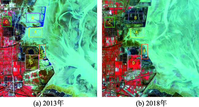
表1 资源三号卫星影像基本信息Tab. 1 The basic information of ZY-3 images in Yancheng coastal wetlands |
| 卫星 | 成像时间 | 空间分辨率/m | 波段:波长/μm |
|---|---|---|---|
| Ziyuan-3 | 2013-03-04 2018-03-22 | 5.8 | 蓝波段:0.45~0.52 绿波段:0.52~0.59 红波段:0.63~0.69 近红外波段:0.77~0.89 |
| [1] |
宫宁, 牛振国, 齐伟, 等. 中国湿地变化的驱动力分析[J]. 遥感学报, 2016,20(2):172-183.
[
|
| [2] |
左平, 李云, 赵书河, 等. 1976年以来江苏盐城滨海湿地景观变化及驱动力分析[J]. 海洋学报(中文版), 2012,34(1):101-108.
[
|
| [3] |
王成军, 毛政元, 徐伟铭, 等. 超像素与主动学习相结合的遥感影像变化检测方法[J]. 地球信息科学学报, 2018,20(2):235-245.
[
|
| [4] |
李杨, 江南, 侍昊, 等. Landsat-8影像的LDA模型变化检测[J]. 地球信息科学学报, 2015,17(3):353-360.
[
|
| [5] |
张志强, 张新长, 辛秦川, 等. 结合像元级和目标级的高分辨率遥感影像建筑物变化检测[J]. 测绘学报, 2018,47(1):102-112.
[
|
| [6] |
|
| [7] |
|
| [8] |
冯文卿, 眭海刚, 涂继辉, 等. 联合像元级和对象级分析的遥感影像变化检测[J]. 测绘学报, 2017,46(9):1147-1155,1164.
[
|
| [9] |
|
| [10] |
|
| [11] |
|
| [12] |
何鹏飞. 基于不确定性分析的遥感影像变化检测方法研究[D]. 徐州:中国矿业大学, 2017.
[
|
| [13] |
|
| [14] |
|
| [15] |
|
| [16] |
郝明. 基于空间信息准确性增强的遥感影像变化检测方法研究[D]. 徐州:中国矿业大学, 2015.
[
|
| [17] |
|
| [18] |
|
| [19] |
郝敬锋, 刘红玉, 李玉凤, 等. 基于转移矩阵模型的江苏海滨湿地资源时空演变特征及驱动机制分析[J]. 自然资源学报, 2010,25(11):1918-1929.
[
|
| [20] |
自然资源部国土卫星遥感应用中心. 自然资源卫星影像云服务平台[DB/OL]. http://sasclouds.com/chinese/normal/.
[ Land Satellite Remote Sensing Application Center, Ministry of Natural Resources. The Cloud Service Platform of Natural Resources Satellite Images[DB/OL]. http://sasclouds.com/chinese/normal/]
|
| [21] |
冷英, 李宁. 一种改进的变化检测方法及其在洪水监测中的应用[J]. 雷达学报, 2017,6(2):204-212.
[
|
/
| 〈 |
|
〉 |