
基于复合指数模型的DMSP/OLS夜间灯光影像饱和校正方法
|
许文鑫(1995— ),男,安徽六安人,硕士研究生,研究方向为城市遥感、大数据分析与应用。E-mail: xuwxfors@foxmail.com |
收稿日期: 2019-09-29
要求修回日期: 2019-12-23
网络出版日期: 2021-01-25
基金资助
国家自然科学基金项目(41771423)
福建省科技重点项目(2018Y0054)
版权
Saturation Correction Method of DMSP/OLS Nighttime Lights Image based on Compound Exponential Model
Received date: 2019-09-29
Request revised date: 2019-12-23
Online published: 2021-01-25
Supported by
National Natural Science Foundation of China(41771423)
Fujian Science and Technology Key Project(2018Y0054)
Copyright
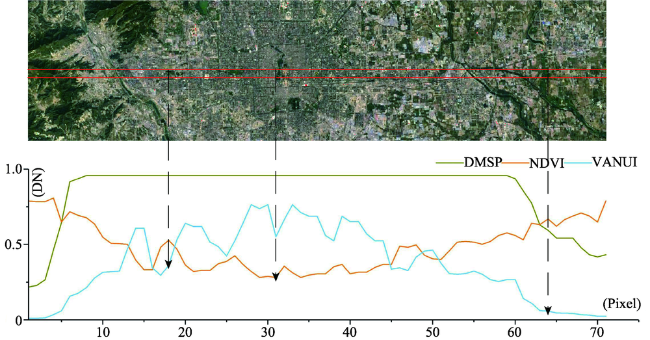
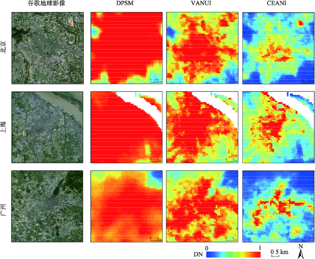
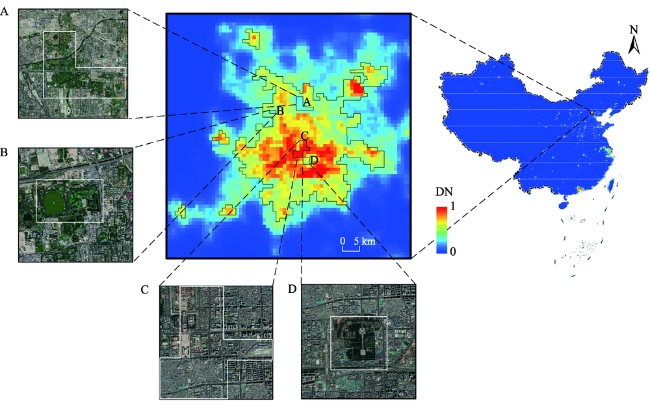
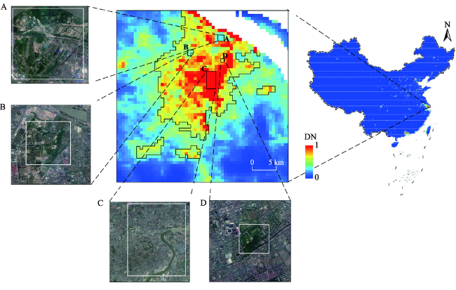
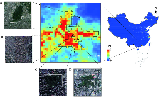
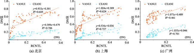
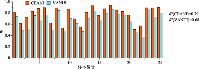
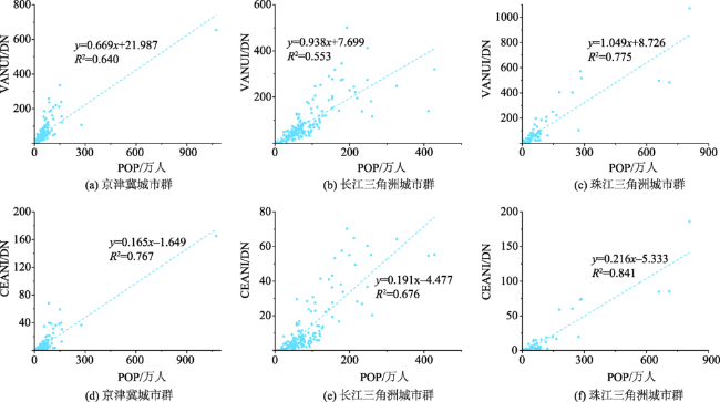
由于OLS传感器航行过程中增益记录和交叉定标的缺失,使得DMSP夜光影像在城市中心出现过度饱和等问题,因此探讨灯光数据去饱和方法在人类活动强度评估和城市时空演化分析等方面具有重要意义。为了解决这一难题,有学者提出使用NDVI修正饱和灯光数据的VANUI指数,为研究灯光数据去饱和提供了简单便捷的思路,然而该指数在部分城市中较难有明显的校正效果。本文在VANUI指数思想的基础上,顾及到人口密度随着郊区到城市中心距离的增加呈现指数型增长,提出了基于复合指数模型校正夜间灯光指数CEANI,为人类活动强度评价等研究提供更准确的结果。研究表明:① 与VANUI相比,CEANI在刻画城市内部饱和区域特征时具有更好的细节,较好地凸显城市内部空间异质性;② 在25组随机样本的相关对比中,CEANI(R2mean=0.79)与辐射定标产品比VANUI(R2mean=0.68)具有更高的相关性;③ 三大城市群中CEANI与常住人口的R2分别为0.767、0.676和0.841,比VANUI(R2分别为0.640、0.553和0.775)分别提高了0.127、0.123、0.066,相较于VANUI,CEANI与常住人口具有更强的相关性,对于人口指标的估算能力更强。

许文鑫 , 梁娟珠 . 基于复合指数模型的DMSP/OLS夜间灯光影像饱和校正方法[J]. 地球信息科学学报, 2020 , 22(11) : 2227 -2237 . DOI: 10.12082/dqxxkx.2020.190559
The lack of gain recording and cross-calibration during the OLS sensor navigation makes DMSP nighttime lights image oversaturated in the city center, which affects the accuracy of using night light data to evaluate human activity intensity. In order to suppress the occurrence of saturation, the radiometric calibration night light data developed by Elvedge have been widely used. The radiometric calibration data products have a high accuracy and strong reliability. However, the calibration process is complex, and the required data is usually difficult to obtain. At present, only a few results have applied the calibration data to the continuity analysis. In recent years, many scholars found that NDVI can desaturate DMSP/OLS night light images and enhance the heterogeneity of urban center. Based on this, non-radiation calibration method has been applied to correct the saturation effect and shown a good correction result. On the basis of summarizing the idea by VANUI that the difference between night light intensity and vegetation coverage shows a decreasing trend from the city center to the suburb, this paper considers that the population density increases exponentially with the increase of rural-urban distance. We proposed a correction of nighttime light index based on compound exponential model (CEANI). Results show that (1) compared with VANUI, CEANI showed better details and spatial heterogeneity when characterizing the saturated regions of the city. In addition, CEANI not only identified areas where human activity was concentrated, such as stations, airports, and business areas with high traffic and people flow, but also clearly identified the areas with high vegetation coverage and low DN values such as forests and parks with sparse road network; (2) in the correlation analysis using 25 random samples, CEANI showed a higher correlation (R2mean = 0.79) with radiometric calibration products than VANUI (R2mean = 0.68); (3) CEANI had a stronger correlation with the number of permanent residents and significantly estimated population indicators better than VANUI, which suggests the better calculation index for describing the intensity of human activity. In summary, the CEANI can be used to correct the saturation problem in DMSP/OLS luminous data products. It better shows the internal details of the city and its spatial heterogeneity, and thus can derive more accurate results for the evaluation of human activity intensity.
| [1] |
郭腾云, 董冠鹏. 基于GIS和DEA的特大城市空间紧凑度与城市效率分析[J]. 地球信息科学学报, 2009,11(4):482-490.
[
|
| [2] |
陈良文, 杨开忠. 集聚与分散:新经济地理学模型与城市内部空间结构、外部规模经济效应的整合研究[J]. 经济学:季刊, 2008,7(1):53-70.
[
|
| [3] |
陈晋, 卓莉, 史培军, 等. 基于DMSP/OLS数据的中国城市化过程研究——反映区域城市化水平的灯光指数的构建[J]. 遥感学报, 2003,7(3):168-175.
[
|
| [4] |
|
| [5] |
王翠平, 王豪伟, 李春明, 等. 基于DMSP/OLS影像的我国主要城市群空间扩张特征分析[J]. 生态学报, 2012,32(3):942-954.
[
|
| [6] |
|
| [7] |
何春阳, 李景刚, 陈晋, 等. 基于夜间灯光数据的环渤海地区城市化过程[J]. 地理学报, 2005,60(3):409-417.
[
|
| [8] |
|
| [9] |
|
| [10] |
|
| [11] |
吴健生, 李双, 张曦文. 中国DMSP-OLS长时间序列夜间灯光遥感数据饱和校正研究[J]. 遥感学报, 2018,22(4):91-102.
[
|
| [12] |
|
| [13] |
|
| [14] |
林中立, 徐涵秋, 黄绍霖. 基于DMSP/OLS夜间灯光影像的中国东部沿海地区城市扩展动态监测[J]. 地球信息科学学报, 2019,21(7):1074-1085.
[
|
| [15] |
陈颖彪, 郑子豪, 吴志峰, 等. 夜间灯光遥感数据应用综述和展望[J]. 地理科学进展, 2019,38(2):55-73.
[
|
| [16] |
|
| [17] |
|
| [18] |
卓莉, 张晓帆, 郑璟, 等. 基于EVI指数的DMSP/OLS夜间灯光数据去饱和方法[J]. 地理学报, 2015,70(8):1339-1350.
[
|
| [19] |
郑子豪, 陈颖彪, 吴志峰, 等. 单元路网长度的DMSP/OLS夜间灯光数据去饱和方法[J]. 遥感学报, 2016,22(1):161-173.
[
|
| [20] |
许伟攀, 李郇, 陈浩辉. 基于城市夜间灯光数据的中美两国城市位序规模分布对比[J]. 地理科学进展, 2018,37(3):385-396.
[
|
| [21] |
仇江啸, 王效科, 逯非, 等. 城市景观破碎化格局与城市化及社会经济发展水平的关系——以北京城区为例[J]. 生态学报, 2012,32(9):2659-2669.
[
|
| [22] |
|
| [23] |
程志刚, 杨欣悦, 董思言, 等. 利用城市夜间灯光资料和NDVI研究成都地区植被覆盖度变化[J]. 气象科技进展, 2016,6(1):14-20.
[
|
| [24] |
倪愿, 周小成, 江威. 结合Landsat数据的DMSP/OLS夜间灯光影像去饱和方法研究[J]. 遥感技术与应用, 2017,32(4):721-727.
[
|
| [25] |
|
| [26] |
|
| [27] |
江威, 何国金, 刘慧婵. NPP/VIIRS和DMSP/OLS夜光数据模拟社会经济参量对比[J]. 遥感信息, 2016,31(4):28-34.
[
|
| [28] |
|
| [29] |
|
| [30] |
|
| [31] |
冷炳荣, 杨永春. 中国城市经济网络结构空间特征及其复杂性分析[J]. 地理学报, 2011,66(2):199-211.
[
|
| [32] |
|
| [33] |
姚常成, 宋冬林. 借用规模、网络外部性与城市群集聚经济[J].产业经济研究,2019(2):76-87.
[
|
| [34] |
钱洁. 基于城市功能演化的上海人口发展趋势分析[J].济南大学学报(社会科学版),2019(4):137-148.
[
|
| [35] |
刘佳纯, 王子成. 广州市流动人口住房变动趋势及动因分析——基于Oaxaca-Blinder与Fairlie方法的分解[J].调研世界,2019(6):21-26.
[
|
| [36] |
卓莉, 陈晋, 史培军, 等. 基于夜间灯光数据的中国人口密度模拟[J]. 地理学报, 2005,60(2):266-276.
[
|
/
| 〈 |
|
〉 |