
基于气象监测网络的森林火险快速预警模型
|
李 玉(1996— ),女,河南信阳人,硕士生,主要从事地理信息安全及GIS应用研究。E-mail: 2447041365@qq.com |
收稿日期: 2019-12-24
要求修回日期: 2020-03-25
网络出版日期: 2021-02-25
基金资助
国家自然科学基金项目(41761080)
甘肃高等学校产业支撑引导项目(2019C-04)
受兰州交通大学优秀平台支持(201806)
河南省自然科学基金资助项目(202300410345)
版权
Forest Fire Risk Rapid Warning Model based on Meteorological Monitoring Network
Received date: 2019-12-24
Request revised date: 2020-03-25
Online published: 2021-02-25
Supported by
National Natural Science Foundation of China(41761080)
Industrial Support and Guidance Projects of Colleges and Universities in Gansu Province(2019C-04)
Funded by LZJTU EP(201806)
Natural Science Foundation of Henan(202300410345)
Copyright
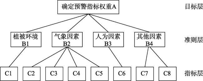
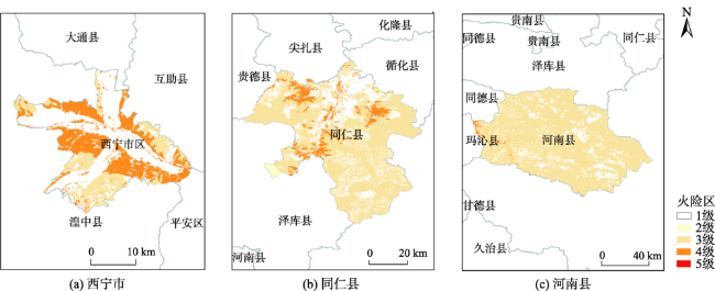
森林火灾发生频繁且突发性强,进行森林火险快速预警对于减小森林火灾损失和促进森林资源可持续发展至关重要。本文基于GIS空间分析和可视化技术,利用地面气象站构建实时气象监测网络,设计了运用气象监测网络的森林火险预警模型,可实现森林火险及时、快速预警。模型应用层次分析法建立了预警因子重要性层次结构并确定预警因子的权重;运用Voronoi图技术,基于气象站点和实时气象数据,构建气象监测网络;利用叠置分析技术计算得出预警结果。基于该模型设计的森林火灾快速预警系统应用于青海省林业局,验证了系统可行性与适用性,该模型可全面、准确、快速地实现对森林火险的预警。结果表明:① 根据预警模型及实时气象监测数据,可及时发出预警信号,快速实现县级、林场级别的森林火险早期预警和及时响应;② 运用GIS可视化技术,可快速生成相关区域森林火险的空间分布专题图,直观地观察预警等级的变化情况。实践表明,森林火险快速预警对森林火灾进行有效预防、中断管理和制定扑救措施具有重要的指导作用,并对森林防火工作、保护森林资源和人类生命财产安全具有重大意义。
李玉 , 张黎明 , 张兴国 , 王昊 , 张鑫港 . 基于气象监测网络的森林火险快速预警模型[J]. 地球信息科学学报, 2020 , 22(12) : 2317 -2325 . DOI: 10.12082/dqxxkx.2020.190799
Forest fire occurs frequently and suddenly. Therefore, it is essential to carry out the rapid warning of forest fire danger for the reduction of the loss caused by forest fire and the promotion of sustainable development of forest resources. This paper designs an early-warning model based on GIS spatial analysis and visualization technology and the construction of real-time meteorological monitoring network using ground meteorological stations, which can achieve timely and rapid warning of forest fire danger. To build the model, this paper first determines the forest fire danger early-warning factors, which are the input parameters of the model. Secondly, a hierarchy model of the importance of early warning indicators is constructed to determine the weight of the early warning factors via using the AHP method and combining the analysis of early warning factors. Then, the thresholds and grade division criteria of the early-warning factor are determined according to the national, industrial, and local regulations for determining forest fire danger levels, which is suitable for the model. Finally, the Voronoi Diagrams are used to establish a meteorological monitoring network based on weather stations and real-time weather data. The Overlay Analysis technology is used to calculate the early warning result. Based on the model and real-time acquisition and processing of data, a rapid warning system for forest fires was constructed. This paper took Qinghai Province as the experimental area where the feasibility and applicability of the system were verified, which indicates that early warning of forest fire danger can be realized by the model comprehensively, accurately, and rapidly. Results show that: (1) According to the early-warning model, the real-time early-warning indicators which were set before, and real-time meteorological monitoring data, the early-warning signal can be sent in time, which can quickly realize early warning and timely response of forest fire risks at the county and forest farm levels; (2) Via introducing GIS visualization methods, the thematic map of forest fire risk spatial distribution can be generated by the model quickly, which is conducive to observe changes in early-warning levels visually. The rapid warning of forest fire risks has important guiding functions for effective prevention, interruption management, and prevention measures of forest fire, and has great significance for forest fire prevention work, protection of forest resources, and safety of human life and property.
表1 1—9比例标度表Tab. 1 Proportional scale of 1-9 |
| 重要性标度 | p因子与q因子比较的结果 |
|---|---|
| 1 | p因子与q因子同等重要 |
| 3 | p因子比q因子稍微重要 |
| 5 | p因子比q因子明显重要 |
| 7 | p因子比q因子强烈重要 |
| 9 | p因子比q因子极端重要 |
| 2,4,6,8 | 重要性介于上述相邻判断的中间值 |
表2 森林火险预警因子的判断矩阵与一致性检验表Tab. 2 Judgment matrix and consistency test of forest fire danger early warning factors |
| 预警因子 | C1 | C2 | C3 | C4 | C5 | C6 | C7 | C8 | 权重 |
|---|---|---|---|---|---|---|---|---|---|
| C1 | 1 | 2 | 2 | 4 | 3 | 6 | 7 | 5 | 0.2957 |
| C2 | 1/2 | 1 | 1 | 3 | 2 | 5 | 6 | 4 | 0.1918 |
| C3 | 1/2 | 1 | 1 | 3 | 2 | 5 | 6 | 4 | 0.1918 |
| C4 | 1/4 | 1/3 | 1/3 | 1 | 1/2 | 3 | 4 | 2 | 0.0811 |
| C5 | 1/3 | 1/2 | 1/2 | 2 | 1 | 4 | 5 | 3 | 0.1234 |
| C6 | 1/6 | 1/5 | 1/5 | 1/3 | 1/4 | 1 | 2 | 1/2 | 0.0364 |
| C7 | 1/7 | 1/6 | 1/6 | 1/4 | 1/5 | 1/2 | 1 | 1/3 | 0.0260 |
| C8 | 1/5 | 1/4 | 1/4 | 1/2 | 1/3 | 2 | 3 | 1 | 0.0538 |
表3 1—10阶平均随机一致性指标Tab. 3 Mean Random Consistency Index of 1-order to 10-order |
| 矩阵阶数 | 1 | 2 | 3 | 4 | 5 | 6 | 7 | 8 | 9 | 10 |
|---|---|---|---|---|---|---|---|---|---|---|
| RI值 | 0 | 0 | 0.52 | 0.89 | 1.12 | 1.26 | 1.36 | 1.41 | 1.46 | 1.49 |
表4 森林火险各预警因子危险级别查对表Tab. 4 Risk level checklist of forest fire danger early-warning factors |
| 级别 | 林业类型范围 | 与道路的 距离/m | 温度范围 /℃ | 湿度范围 /% | 风力范围 /(m/s) | 连续无效降雨天数/d | 干旱指标 | 季节 |
|---|---|---|---|---|---|---|---|---|
| 1 | 0.0~0.99 | 20 000~100 000 | -60~20 | 90~100 | 0.0~0.2 | 0~3 | 无干旱 | - |
| 2 | 0.99~1.0 | 13 000~20 000 | -20~0 | 80~90 | 0.2~1.5 | 4~6 | 无干旱 | - |
| 3 | 1.0~1.5 | 10 000~13 000 | 0~5 | 70~80 | 1.5~3.3 | 7~10 | 无干旱 | - |
| 4 | 1.5~2.0 | 8000~10 000 | 5~10 | 60~70 | 3.3~5.4 | 11~20 | 轻度干旱 | - |
| 5 | 2.0~2.5 | 6000~8000 | 10~15 | 50~60 | 5.4~8.0 | 21~25 | 中度干旱 | - |
| 6 | 2.5~3.0 | 4500~6000 | 15~20 | 40~50 | 8.0~10.8 | 26~30 | 中度干旱 | 夏 |
| 7 | 3.0~3.5 | 3000~4500 | 20~25 | 30~40 | 10.8~13.8 | 31~35 | 严重干旱 | - |
| 8 | 3.5~4.0 | 1800~3000 | 25~30 | 20~30 | 13.8~17.2 | 35~40 | 严重干旱 | 春/秋 |
| 9 | 4.0~4.5 | 800~1800 | 30~35 | 10~20 | 17.2~20.7 | 40~45 | 严重干旱 | - |
| 10 | 4.5~5.0 | 0~800 | 35~60 | 0~10 | 20.7~50.0 | >45 | 极度干旱 | 冬 |
表5 森林火险预警等级划分表Tab. 5 Classification of forest fire danger warning level |
| 林火天气预警等级 | 名称 | 危险程度 | 栅格图层预警结果 | 颜色 | 预警标志 |
|---|---|---|---|---|---|
| 一级 | 低火险 | 低 | -800~1.0 | 无色 | - |
| 二级 | 较低火险 | 较低 | 1.0~4.8 | 淡黄色 | - |
| 三级 | 较高火险 | 较高 | 4.8~6.5 | 浅橙色 | 黄旗 |
| 四级 | 高火险 | 高 | 6.5~8.2 | 橙色 | 橙旗 |
| 五级 | 极高火险 | 极高 | 8.2~10.0 | 红色 | 红旗 |
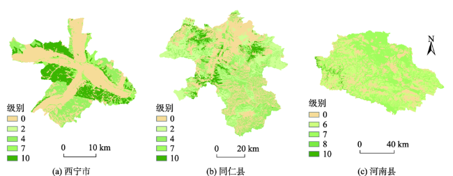
图2 青海省林业类型危险级别分布Fig. 2 Risk level distribution of forestry types in Qinghai Province |
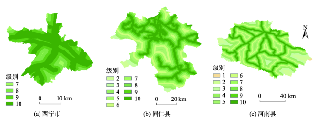
图3 青海省与道路的距离危险级别分布Fig. 3 Risk level distribution of distance from roads in Qinghai Province |
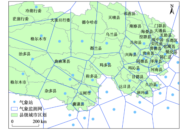
表6 青海省森林火险预警实验数据集Tab. 6 Experimental data set of forest fire danger early warning in Qinghai Province |
| 时间 | 气象因子 | 西宁市 | 同仁县 | 河南县 | |||
|---|---|---|---|---|---|---|---|
| 监测值 | 级别 | 监测值 | 级别 | 监测值 | 级别 | ||
| 2019年4月1日10时 | 温度 | 9.4 | 4 | 9.7 | 4 | 5.3 | 4 |
| 湿度 | 24 | 7 | 26 | 8 | 50 | 8 | |
| 风力 | 2.5 | 3 | 2.3 | 7 | 2.4 | 5 | |
| 干旱 | 极度干旱 | 10 | 极度干旱 | 10 | 极度干旱 | 10 | |
| 季节 | 春季 | 8 | 春季 | 8 | 春季 | 8 | |
| [1] |
李静, 宫阿都, 陈艳玲, 等. 森林过火区植被遥感参数的变化与恢复特征分析[J]. 地球信息科学学报, 2018,20(3):368-376.
[
|
| [2] |
杨晓丹, 赵鲁强, 宋建洋, 等. 耦合植被与T639模式的森林火险气象潜势预报[J]. 科技导报, 2018,36(8):87-92.
[
|
| [3] |
舒立福, 田晓瑞. 国外森林防火工作现状及展望[J]. 世界林业研究, 1997(2):29-37.
[
|
| [4] |
牛若芸, 翟盘茂, 孙明华. 森林火险气象指数及其构建方法回顾[J]. 气象, 2006(12):3-9.
[
|
| [4] |
舒立福, 张小罗, 戴兴安, 等. 林火研究综述(Ⅱ)——林火预测预报[J]. 世界林业研究, 2003(4):34-37.
[
|
| [6] |
张伟, 王峰, 郭艳芬, 等. 基于Logistic回归的森林火险天气等级模型[J]. 东北林业大学学报, 2013(12):123-124,133.
[
|
| [7] |
王正非. 三指标林火预报法[J]. 生态学杂志, 1988,7(S1):75-81.
[
|
| [8] |
覃先林, 张子辉, 李增元, 等. 林火预警及实现方法[J]. 北京林业大学学报, 2010(4):23-27.
[
|
| [9] |
|
| [10] |
|
| [11] |
LY/T 1172-95全国森林火险天气等级[S]. 北京:中华人民共和国林业部, 1995.
[ LY/T 1172-95 National Forest Fire Weather Danger Class[S]. Beijing: The state forestry administration of the People's Republic of China, 1995. ]
|
| [12] |
梁莉, 杨晓丹, 王成鑫, 等. 修正的布龙-戴维斯森林火险气象指数模型在中国的适用性[J]. 科技导报, 2019,37(20):65-75.
[
|
| [13] |
|
| [14] |
|
| [15] |
国家气象科学数据中心. 中国气象数据网[EB/OL]. http://data.cma.cn, 2019.
[ National meteorological information center. China meteorological data service center[EB/OL]. http://data.cma.cn, 2019.]
|
| [16] |
王娟, 赵江平, 张俊, 等. 我国森林火灾预测及风险分析[J]. 中国安全生产科学技术, 2008(4):41-45.
[
|
| [17] |
田晓瑞, 舒立福, 赵凤君, 等. 气候变化对中国森林火险的影响[J]. 林业科学, 2017,53(7):159-169.
[
|
| [18] |
郑忠, 高阳华, 杨庆媛, 等. 西南山地区域森林火险综合预报模型研究——以重庆市为例[J]. 自然灾害学报, 2020,29(1):152-161.
[
|
| [19] |
徐明超, 马文婷. 干旱气候因子与森林火灾[J]. 冰川冻土, 2012,34(3):603-608.
[
|
| [20] |
|
| [21] |
LY/T 1063-2008全国森林火险区划等级[S]. 北京:中华人民共和国国家林业局, 2008.
[ LY/T 1063-2008 Rank of the Regionalization on Nationwide Forest Fire Risk[S]. Beijing: The state forestry administration of the People's Republic of China, 2008. ]
|
/
| 〈 |
|
〉 |