
基于Bayes网络的多粒度时空对象地理过程演化建模——以新安江模型为例
|
张正方(1995— ),男,河南安阳人,硕士生,主要从事地理建模与分析方面研究。E-mail: 837367502@qq.com |
收稿日期: 2020-07-31
修回日期: 2020-12-25
网络出版日期: 2021-03-25
基金资助
国家重点研发计划项目课题(2016YFB0502301)
国家自然科学基金项目(41976186)
版权
Modeling of Geographical Process Evolution of Spatio-temporal Objects of Multi-granularity based on Bayesian Network: A Case Study of the Xin'an Jiang Model
Received date: 2020-07-31
Revised date: 2020-12-25
Online published: 2021-03-25
Supported by
National Key Research and Development Program of China(2016YFB0502301)
National Natural Science Foundation of China(41976186)
Copyright
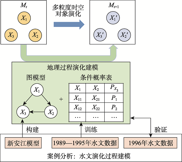
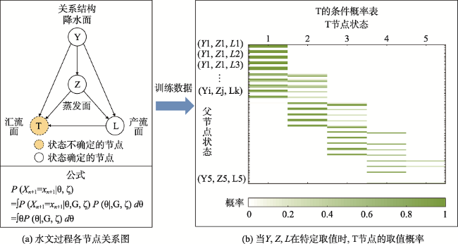
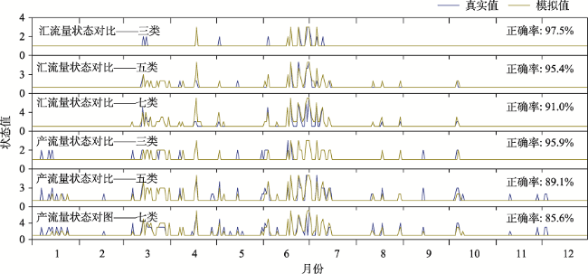
多粒度时空对象具有多粒度、多类型、多形态、多参照系、多元关联、多维动态、多能自主特点,可用于直接描述从微观到宏观的现实世界。基于时空对象建模理论构建多尺度地理对象耦合演化的集成表达是多粒度时空对象模型支撑地理分析与建模的关键。本文基于多粒度时空对象建模理论,在概率图和条件概率表的基础上发展了一种基于Bayes网络的地理过程演化表达和建模方法。该方法将多粒度时空对象作为Bayes网络节点,根据多粒度时空对象间的关联关系构建Bayes网络,利用Bayes概率表达多粒度时空对象间关联关系的作用强度,并通过更新算子和概率图模型描述要素特征状态的动态变化。基于此方法,选取新安江模型,进行多粒度时空对象地理过程建模和模拟实验。采用呈村1989—1995年水文数据为训练数据,1996年水文数据为模拟数据,通过降水面、蒸发面、产流面和汇流面构造Bayes网络并模拟产流量和汇流量状态;实验结果表明本文方法不仅可以对水文过程进行演化建模,并且可以较好地模拟水文过程中的产流量和汇流量变化,正确率达97.5%和95.9%。
张正方 , 闫振军 , 王增杰 , 傅蓉 , 罗文 , 俞肇元 . 基于Bayes网络的多粒度时空对象地理过程演化建模——以新安江模型为例[J]. 地球信息科学学报, 2021 , 23(1) : 124 -133 . DOI: 10.12082/dqxxkx.2021.200426
Spatio-temporal objects of multi-granularity have the characteristics of multi-granularity, multi-type, multi-form, multi-reference system, multi-relation, multi-dimensional dynamics, and multi-energy autonomy. It can be used to directly describe the real world from micro to macro. Based on the spatio-temporal objects modeling theory, constructing the integrated expression of the coupled evolution of multi-scale geographic objects is the key to supporting geographic analysis and modeling with spatio-temporal objects of multi-granularity model. Based on spatio-temporal objects of multi-granularity modeling theory, this paper develops a Bayesian network-based geographic process evolution expression and modeling method on the basis of probability diagrams and conditional probability tables. This method uses spatio-temporal objects of multi-granularity as Bayesian network nodes, and constructs Bayesian network according to the association relationship between spatio-temporal objects of multi-granularity. It uses Bayesian probability to express the strength of the relationship between spatio-temporal objects of multi-granularity. And it describes the dynamic changes of the feature state of the elements through the update operator and the probability graph model. Based on this method, the Xin'anjiang Model is selected to conduct the modeling and simulation experiment of the geographic process of spatio-temporal objects of multi-granularity. This paper uses the hydrological data of Chengcun Village from 1989 to 1995 as training data, and the hydrological data of 1996 as simulated data. Using precipitation surface, evaporation surface, runoff surface and confluence surface to construct Bayesian network and simulate the state of runoff and sink flow. The experimental results show that the method can not only model the evolution of hydrological process, but also can simulate the changes of runoff and sink flow in the hydrological process, and the correct rate can reach 97.5% and 95.9%.
表1 水文模型变量状态分级Tab.1 Hydrological model variable state score table |
| 状态 | Y/mm | Z/mm | L/mm | T/(m3/s) | |
|---|---|---|---|---|---|
| 三类分级 | 一级 | <16.1 | <1.5 | <14.3 | <4.3 |
| 二级 | 16.1~63.8 | 1.5~3.4 | 14.3~62.6 | 4.3~19.2 | |
| 三级 | >63.8 | >3.4 | >62.6 | >19.2 | |
| 五类分级 | 一级 | <5.7 | <0.8 | <5.4 | <1.3 |
| 二级 | 5.7~18.8 | 0.8~1.6 | 5.4~18.2 | 1.3~5.4 | |
| 三级 | 18.8~37.7 | 1.6~2.8 | 18.2~40.5 | 5.4~13.9 | |
| 四级 | 37.7~68 | 2.8~4.3 | 40.5~81.9 | 13.9~31.9 | |
| 五级 | >68 | >4.3 | >81.9 | >31.9 | |
| 七类分级 | 一级 | <3.8 | <0.5 | <3.3 | <0.6 |
| 二级 | 3.8~12.0 | 0.5~1.1 | 3.3~10.7 | 0.6~2.0 | |
| 三级 | 12.0~23.7 | 1.1~1.7 | 10.7~21.7 | 2.0~4.2 | |
| 四级 | 23.7~41.2 | 1.7~2.5 | 21.7~38.2 | 4.2~7.5 | |
| 五级 | 41.2~68.0 | 2.5~3.6 | 38.2~65.7 | 7.5~13.9 | |
| 六级 | 68.0~120.6 | 3.6~4.9 | 65.7~113.9 | 13.9~31.9 | |
| 七级 | >120.6 | >4.9 | >113.9 | >31.9 |
| [1] |
华一新, 周成虎 . 面向全空间信息系统的多粒度时空对象数据模型描述框架[J]. 地球信息科学学报, 2017,19(9):1-4.
[
|
| [2] |
王健健, 王艳楠, 周良辰 , 等. 多粒度时空对象关联关系的分类体系与表达模型[J]. 地球信息科学学报, 2017,19(9):1164-1170.
[
|
| [3] |
华一新 . 全空间信息系统的核心问题和关键技术[J]. 测绘科学技术学报, 2016,33(4):331-335.
[
|
| [4] |
萧声隽, 宗真, 项丽燕 , 等. 多粒度时空对象空间关系的统一表达与计算[J]. 地球信息科学学报, 2017,19(9):1178-1184.
[
|
| [5] |
|
| [6] |
闾国年, 袁林旺, 俞肇元 . 地理学视角下测绘地理信息再透视[J]. 测绘学报, 2017,46(10):1549-1556.
[
|
| [7] |
|
| [8] |
|
| [9] |
|
| [10] |
|
| [11] |
|
| [12] |
|
| [13] |
|
| [14] |
|
| [15] |
|
| [16] |
|
| [17] |
|
| [18] |
|
| [19] |
|
| [20] |
李冬双, 刘袁, 石格格 , 等. 基于时变网络的多粒度时空对象关系演化过程表达与建模[J]. 地球信息科学学报, 2017,19(9):1171-1177.
[
|
| [21] |
|
| [22] |
|
| [23] |
|
| [24] |
|
| [25] |
|
| [26] |
董洁平, 李致家, 戴健男 . 基于SCE-UA算法的新安江模型参数优化及应用[J]. 河海大学学报(自然科学版), 2012,40(5):485-490.
[
|
| [27] |
刘金涛, 宋慧卿, 张行南 , 等. 新安江模型理论研究的进展与探讨[J]. 水文, 2014,34(1):1-6.
[
|
/
| 〈 |
|
〉 |
