
面向自然资源统一管理的多源土地利用信息一致性分析评价
|
刘 稳(1991- ),男,湖北咸宁人,博士生,现主要从事大数据在国土空间规划中的应用、数字城乡规划与管理等研究。E-mail: lw_whu@whu.edu.cn |
收稿日期: 2020-02-08
要求修回日期: 2020-04-17
网络出版日期: 2021-05-25
基金资助
国家自然科学基金项目(52078389)
国家自然科学基金项目(51878515)
国家自然科学基金项目(41331175)
版权
Consistency Evaluation of Multi-source Land Use Information to Unify the Management of Natural Resources
Received date: 2020-02-08
Request revised date: 2020-04-17
Online published: 2021-05-25
Supported by
National Natural Science Foundation of China(52078389)
National Natural Science Foundation of China(51878515)
National Natural Science Foundation of China(41331175)
Copyright
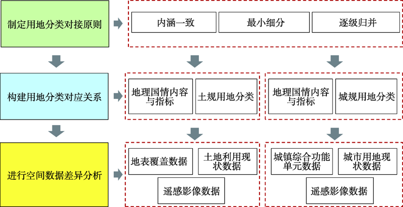
在国家机构改革和规划体制改革的背景下,理清地理国情监测与其他自然资源调查监测成果的差异,发挥其客观、精细等优势特征,促进其更好地服务于自然资源调查监管和国土空间开发管控显得迫切需要。本文以武汉市为研究对象,通过对地理国情内容指标与“两规”用地分类标准进行对比分析,并选取地理国情监测数据与“两规”用地数据进行对接试验,综合考虑不同数据之间的一致性特征以及地理国情监测在国土空间开发管控中的适用性,提出新时期地理国情监测工作的优化建议。研究表明,地理国情监测数据与“两规”用地数据在分类指导思想、分类构成体系、数据技术标准等方面存在不同程度、不同类型的差异,导致其直接用于国土空间规划编制尚且较难;今后地理国情监测应明确其作为专题监测在自然资源调查监测体系中的作用和定位,进一步完善监测内容、优化分类体系、统一技术标准,促进其更好地应用于自然资源调查监管和国土空间开发管控。
刘稳 , 詹庆明 , 赵中元 , 林苏靖 , 肖琨 , 李荣 . 面向自然资源统一管理的多源土地利用信息一致性分析评价[J]. 地球信息科学学报, 2021 , 23(3) : 365 -376 . DOI: 10.12082/dqxxkx.2021.200063
In the context of China's planning system reform, territorial space planning is one of the important methods that promote the scientific management of natural resources and realize regional sustainable development. It is helpful to solve the overlaps and contradictions between land use planning, urban planning, and main functional area planning. In order to improve the reasonableness and authority of natural resources surveys and territorial space management, with the advantages of objective and precise geographical conditions monitoring data, it is urgent to clarify the differences between geographical conditions monitoring and other natural resources surveys, so as to better serve the survey and supervision of natural resources and the management of territorial space. This paper first analyzes the differences in land use classifications between the geographical conditions monitoring and the “two plans”, and then selects a specific experimental area in Wuhan for an empirical analysis. Finally, given the differences of data between geographical conditions monitoring and the “two plans” land use and the applicability of geographical conditions monitoring in territorial space planning, we put forward some suggestions for optimizing geographical conditions monitoring for territorial space management in the new era. The results show that there are different degrees and types of differences in the guiding principles, composition system, and technical standards of land use classification for geographical conditions monitoring data and “two plans” land use data, which makes the former difficult to be directly applied to the compilation of territorial space planning. In order to promote the application of geographical conditions monitoring datasets in compilation, implementation, and management of territorial space planning, it is necessary to further define its basic position in the system of natural resources survey, monitoring, and management, improve the monitoring content, optimize the classification system, and unify the technical standards. With the preliminary construction of natural resources survey and monitoring system and gradual improvement of territorial space planning system, geographical conditions monitoring should rely on its technical advantages, clarify its service content and objects, and build a comprehensive application framework system in the future to make it play an important role in natural resources management.
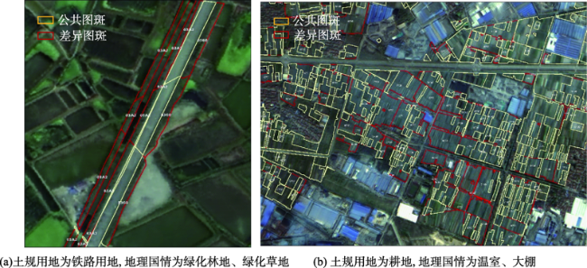
表1 武汉市地理国情地表覆盖数据与土规用地数据的试验分析Tab. 1 Experimental results of geographical conditions monitoring data and land use planning data in Wuhan |
| 土规用地分类 | 对应关系 | 地理国情地表覆盖分类 | 重合度/% | |
|---|---|---|---|---|
| 一级类 | 二级类 | |||
| 耕地 | 一对一 | 耕地 | 58.8 | |
| 水田 | 一对一 | 水田 | 28.1 | |
| 水浇地、旱地 | 一对多 | 旱地 | 53.8 | |
| 园地 | 多对一 | 园地 | 62.3 | |
| 果园 | 一对一 | 果园 | 25.3 | |
| 茶园 | 一对一 | 茶园 | 62.5 | |
| 其他园地 | 多对一 | 桑园、橡胶园、其他园地、花圃 | 6.4 | |
| 林地 | 多对一 | 林地 | 83.2 | |
| 有林地 | 多对一 | 乔木林、竹林 | 86.3 | |
| 灌木林地 | 一对一 | 灌木林 | 11.6 | |
| 其他林地 | 多对一 | 苗圃、疏林、人工幼林 | 6.9 | |
| 草地 | 多对一 | 草地 | 47.7 | |
| 天然牧草地 | 一对一 | 天然草地 | - | |
| 人工牧草地 | 一对一 | 牧草地 | - | |
| 其他草地 | 多对一 | 固沙灌草、绿化草地、护坡灌草、其他人工草地 | 0.01 | |
| 交通运输 用地 | 多对一 | 有轨道路、无轨道路、绿化林地、绿化草地、护坡灌草、广场、其他硬化地表、停车场、停机坪与跑道、房屋建筑区 | 32.8 | |
| 铁路用地 | 多对一 | 有轨道路、绿化林地、绿化草地、护坡灌草、广场、其他硬化地表、停车场、房屋建筑区 | 51.5 | |
| 公路用地、街巷用地、农村道路 | 多对多 | 无轨道路、绿化林地、绿化草地、护坡灌草、广场、其他硬化地表、停车场、房屋建筑区 | 48.4 | |
| 机场用地 | 多对一 | 停机坪与跑道、绿化林地、绿化草地、护坡灌草、广场、其他硬化地表、停车场、房屋建筑区 | 25.2 | |
| 港口码头用地 | 一对一 | 其他硬化地表、化林地、绿化草地、护坡灌草、房屋建筑区 | - | |
| 管道运输用地 | 无对应 | - | - | |
| 水域(不含水工建筑用地) | 多对一 | 水域、裸露地、水工设施、草地、林地、房屋建筑区 | 91.6 | |
| 河流水面 | 一对一 | 河流 | 99.3 | |
| 湖泊水面 | 一对一 | 湖泊 | 97.8 | |
| 水库水面 | 一对一 | 水库 | 96.7 | |
| 坑塘水面 | 一对一 | 坑塘 | 58.3 | |
| 沿海滩涂 | 多对一 | 裸露地、水域、草地、林地 | - | |
| 内陆滩涂 | 多对一 | 裸露地、水域、草地、林地 | - | |
| 沟渠 | 一对一 | 水渠、房屋建筑区 | 38.2 | |
| 水工建筑用地 | 多对一 | 水工设施、房屋建筑区 | 6.8 | |
| 冰川及永久积雪 | 一对一 | 冰川与常年积雪 | - | |
| 其他土地 | 多对一 | 碾压踩踏地表、场院、温室大棚、房屋建筑区、盐碱地表、泥土地表、沙质地表、砾石地表、岩石地表 | 3.8 | |
| 空闲地 | 一对一 | 碾压踩踏地表 | - | |
| 设施农用地 | 多对一 | 场院、温室大棚、房屋建筑区 | 0.9 | |
| 田坎 | 一对一 | 碾压踩踏地表 | - | |
| 盐碱地 | 一对一 | 盐碱地表 | - | |
| 沼泽地 | 一对一 | 泥土地表 | - | |
| 沙地 | 一对一 | 沙质地表 | - | |
| 裸地 | 多对一 | 泥土地表、砾石地表、岩石地表 | 4.1 | |
| 城镇村及 工矿用地 | 多对一 | 房屋建筑区、道路、露天采掘场、尾矿堆放物、绿化林地、绿化草地等 | 6.2 | |
| 城市、建制镇、村庄 | 多对多 | 房屋建筑区、道路、露天采掘场、尾矿堆放物、绿化林地、绿化草地等 | - | |
| 采矿用地 | 多对一 | 露天采掘场、尾矿堆放物 | 6.2 | |
| 风景名胜区及特殊用地 | 无对应 | - | - | |
注: “-”指无对应的地理国情地表覆盖分类,或因试验区范围内未覆盖该地类图斑而无数据一致性结果。 |
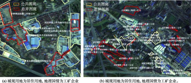
表2 武汉市地理国情城镇综合功能单元数据与城规用地数据的试验分析Tab. 2 Experimental results of geographical conditions monitoring data and urban planning data in Wuhan |
| 城规用地分类 | 对应关系 | 地理国情城镇综合功能单元分类 | 重合率/% | |
|---|---|---|---|---|
| 大类 | 中类 | |||
| 居住用地 | 一对一 | 居住小区 | 81.9 | |
| 公共管理与公共服务用地 | 多对一 | 行政办公、文化设施、教育科研、体育活动场所、医疗卫生、社会福利、名胜古迹 | 69.4 | |
| 行政办公用地 | 一对一 | 行政办公 | 41.2 | |
| 文化设施用地 | 一对一 | 文化设施 | 86.6 | |
| 教育科研用地 | 一对一 | 教育科研 | 79.9 | |
| 体育用地、康体用地 | 一对多 | 体育活动场所 | 19.6 | |
| 医疗卫生用地 | 一对一 | 医疗卫生 | 91.9 | |
| 社会福利用地 | 一对一 | 社会福利 | 43.4 | |
| 文物古迹用地 | 一对一 | 名胜古迹 | - | |
| 外事用地 | 无对应 | - | - | |
| 宗教用地 | 一对一 | 宗教场所 | 97.3 | |
| 商业服务业设施用地 | 多对一 | 商业设施、商务设施、娱乐康体、公用社会营业网点 | 45.4 | |
| 商业设施用地 | 一对一 | 商业设施 | 54.9 | |
| 商务用地 | 一对一 | 商务设施 | 26.9 | |
| 娱乐用地 | 一对一 | 娱乐康体 | 45.6 | |
| 公用设施营业网点用地 | 一对一 | 公用设施营业网点 | 44.3 | |
| 其他服务设施用地 | 无对应 | - | - | |
| 工业用地、物流仓储用地、公用设施用地 | 一对多 | 工矿企业 | 79.7 | |
| 道路与交通设施用地 | 交通设施 | 26.8 | ||
| 城市道路用地 | 无对应 | - | - | |
| 城市轨道交通用地 | 无对应 | - | - | |
| 交通枢纽用地、交通场站用地、 其他交通设施用地 | 一对多 | 交通设施 | 26.8 | |
| 绿地与广场用地 | 一对一 | 休闲娱乐、景区 | 62.5 | |
| 公园绿地、广场用地 | 一对多 | 休闲娱乐、景区 | 62.5 | |
| 防护绿地 | 无对应 | - | - | |
| 生产绿地 | 无对应 | - | - | |
| 其他绿地 | 无对应 | - | - | |
| 待建用地 | 无对应 | - | - | |
注:“-”指无对应的地理国情城镇综合功能单元分类,或因试验区范围内未覆盖该地类图斑而无数据一致性结果。 |
| [1] |
王岳. 重庆市空间规划体系改革实践[J]. 城市规划学刊, 2018(2):50-56.
[
|
| [2] |
谢映, 段宁, 江叶帆, 等. 机构改革背景下长沙市级空间规划体系探索[J]. 规划师, 2018,34(10):38-45.
[
|
| [3] |
中共中央, 国务院. 关于建立国土空间规划体系并监督实施的若干意见[M]. 北京: 人民出版社, 2019.
[ The Communist Party of China Central Committee and
|
| [4] |
桂德竹, 王硕, 张成成. “多规合一”空间规划底图编制方法[J]. 测绘与空间地理信息, 2016,39(8):20-23.
[
|
| [5] |
陈俊勇. 地理国情监测的学习札记[J]. 测绘学报, 2012,41(5):633-635.
[
|
| [6] |
李德仁, 马军, 邵振峰. 论地理国情普查和监测的创新[J]. 武汉大学学报·信息科学版, 2018,43(1):1-9.
[
|
| [7] |
李德仁, 丁霖, 邵振峰. 关于地理国情监测若干问题的思考[J]. 武汉大学学报·信息科学版, 2016,41(2):143-147.
[
|
| [8] |
张琴琴, 杨柏林, 李娜娜, 等. 地理国情普查试点成果综合分析[J]. 测绘科学, 2016,41(4):83-88.
[
|
| [9] |
董春, 刘纪平, 程鹏飞, 等. 地理国情统计分析的服务内容和对象及领域探讨[J]. 测绘科学, 2019,44(6):263-272.
[
|
| [10] |
乔朝飞. 国外地理国情监测概况与启示[J]. 测绘通报, 2011(11):81-83.
[
|
| [11] |
巩垠熙, 王莺, 梁敏, 等. 地理国情信息支撑下的空间开发适宜性评价[J]. 测绘通报, 2017,7:66-71.
[
|
| [12] |
余晓敏, 李兵, 詹庆明, 等. 基于地理国情时空数据的城市建成区动态监测[J]. 地理空间信息, 2015,13(6):8-11.
[
|
| [13] |
吴正鹏. 基于地理国情数据的天津滨海新区建成区动态监测[J]. 测绘通报, 2016(S2):254-257.
[
|
| [14] |
李艳红, 胡勇. 地理国情普查成果在海绵城市中的应用初探[J]. 测绘与空间地理信息, 2017,40(8):71-75.
[
|
| [15] |
程滔, 周旭, 郑新燕, 等. 地理国情监测水面数据时空一致性优化方法[J]. 地球信息科学学报, 2018,20(9):1216-1224.
[
|
| [16] |
郭雷, 胡婵娟, 高红莉, 等. 基于地理国情普查数据的郑州市海绵城市建设途径研究[J]. 中国人口·资源与环境, 2018,28(S1):37-40.
[
|
| [17] |
刘稳, 詹庆明, 赵中元, 等. 面向国土空间规划的不同用地分类体系差异与融合[J]. 城市发展研究, 2020,27(6):9-18.
[
|
| [18] |
刘稳, 詹庆明, 刘权毅, 等. 地理国情监测成果与规划用地数据的关联转换方法[J]. 地球信息科学学报, 2020,22(2):161-174.
[
|
| [19] |
张凤瑞. 地理国情与城市总体规划评估用地分类体系衔接探讨[J]. 测绘通报, 2016(5):116-119.
[
|
| [20] |
马世发, 邹威, 欧阳雪敏. 三生协调的地理国情综合统计分析框架设计[J]. 测绘科学, 2017,42(10):80-87.
[
|
| [21] |
郑志宏. 空间规划底图数据编制与数据库建设探讨[J]. 测绘通报, 2018(7):126-128.
[
|
| [22] |
中华人民共和国自然资源部. 关于全面开展国土空间规划工作的通知[EB/OL]. http://gi.mnr.gov.cn/201905/t20190530_2439129.html, 2019-05-28.
[ Ministry of Natural Resources of the People's Republic of China. Guidelines on comprehensively carrying out national territory spatial planning[EB/OL]. http://gi.mnr.gov.cn/201905/t20190530_2439129.html, 2019-05-28.]
|
| [23] |
国家质量监督检验检疫总局, 国家标准化管理委员会. 土地利用现状分类(GB/T21010-2017)[S]. 北京: 中国标准出版社, 2017.
[ General Administration of Quality Supervision, Inspection Quarantine of the People's Republic of China, Standardization and Administration of the People's Republic of China. Current Land Use Classification (GB/T21010- 2017)[S]. Beijing: Standards Press of China, 2017. ]
|
| [24] |
叶昌东, 郑延敏, 张媛媛. “两规”新旧土地利用分类体系比较[J]. 热带地理, 2013,33(3):276-281.
[
|
| [25] |
林坚, 楚建群, 张书海, 等. 城乡统筹视角下的规划用地分类探讨[J]. 城市规划, 2012,36(4):49-53.
[
|
| [26] |
国务院第一次全国地理国情普查领导小组办公室. 地理国情普查内容与指标[S]. 北京: 测绘出版社, 2013.
[ Leading Group Office of China's First National Geographic Conditions Census of the State Council. Contents and indexes of national geographic conditions census[M]. Beijing: Surveying and Mapping Press, 2013. ]
|
| [27] |
国家质量监督检验检疫总局, 国家标准化管理委员会. 土地利用现状分类(GB/T21010-2007)[S]. 北京: 中国标准出版社, 2007.
[ General Administration of Quality Supervision, Inspection Quarantine of the People's Republic of China, Standardization and Administration of the People's Republic of China. Current Land Use Classification (GB/T21010- 2007) [S]. Beijing: Standards Press of China, 2007. ]
|
| [28] |
中华人民共和国住房和城乡建设部. 城市用地分类与规划建设用地标准[S]. 北京: 中国建筑工业出版社, 2012. ]
[ Ministry of Housing and Urban-Rural Construction of the People's Republic of China. Standards for classification and planning of urban land for construction[S]. Beijing: Standards Press of China, 2007. ]
|
| [29] |
肖继春. 重庆市城市用地现状遥感调查研究[J]. 国土资源遥感, 1995(2):7-14.
[
|
| [30] |
李双林, 彭清山. 武汉市用地现状遥感综合调查及数字化建库[J]. 测绘通报, 1997(10):13-15.
[
|
| [31] |
国务院第三次全国土地调查领导小组办公室. 第三次全国土地调查技术规程[S]. 2018.
[ Leading Group Office of China's Third National Land Survey of the State Council. Technical regulations for the third national land survey[S]. 2018. ]
|
| [32] |
中华人民共和国自然资源部. 自然资源调查监测体系构建总体方案[S]. 2019.
[ Ministry of Natural Resource of the People's Republic of China. The overall plan for the construction of natural resources investigation and monitoring system[S]. 2019. ]
|
/
| 〈 |
|
〉 |