
一种采用SRTM DEM重构河床数字地形的方法
|
孔 乔(1995- ),男,山东曲阜人,硕士生,主要从事水文水资源研究。E-mail: qiao199571218@163.com |
收稿日期: 2019-12-29
要求修回日期: 2020-03-22
网络出版日期: 2021-05-25
基金资助
2018年河口海岸交通行业重点实验室开放课题(KLECE201802)
版权
Methodology of Digital Riverbed Reconstruction based on SRTM DEM Data
Received date: 2019-12-29
Request revised date: 2020-03-22
Online published: 2021-05-25
Supported by
2018 Open Project of Key Laboratory of Estuarine & Coastal Transportation Industry(KLECE201802)
Copyright
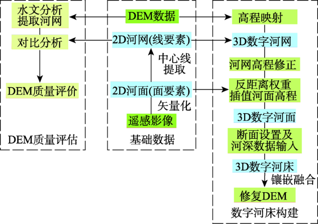
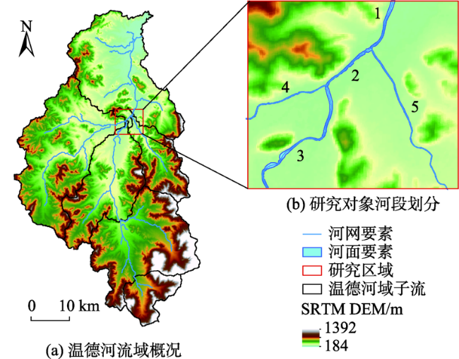
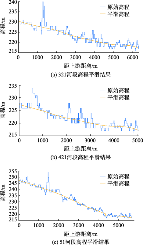
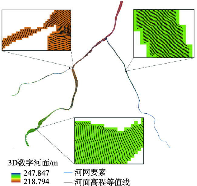
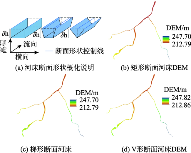
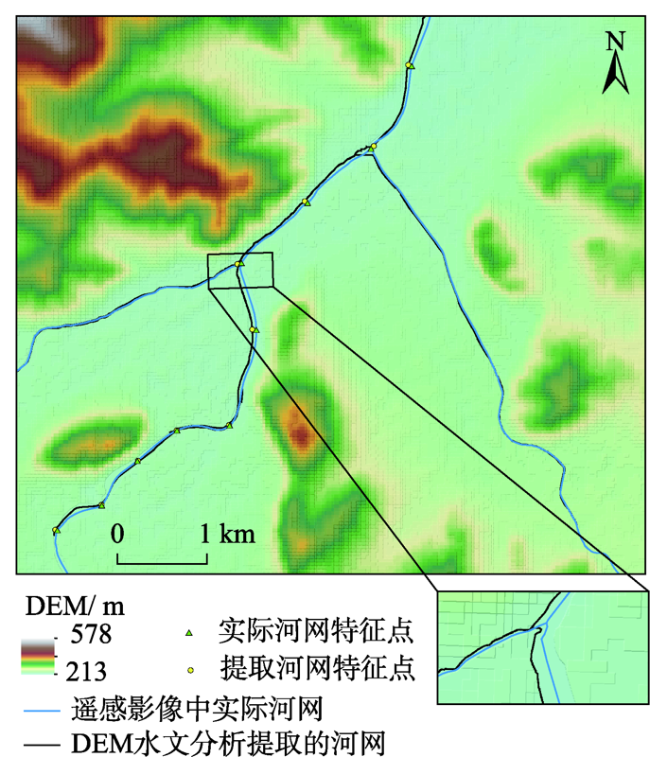
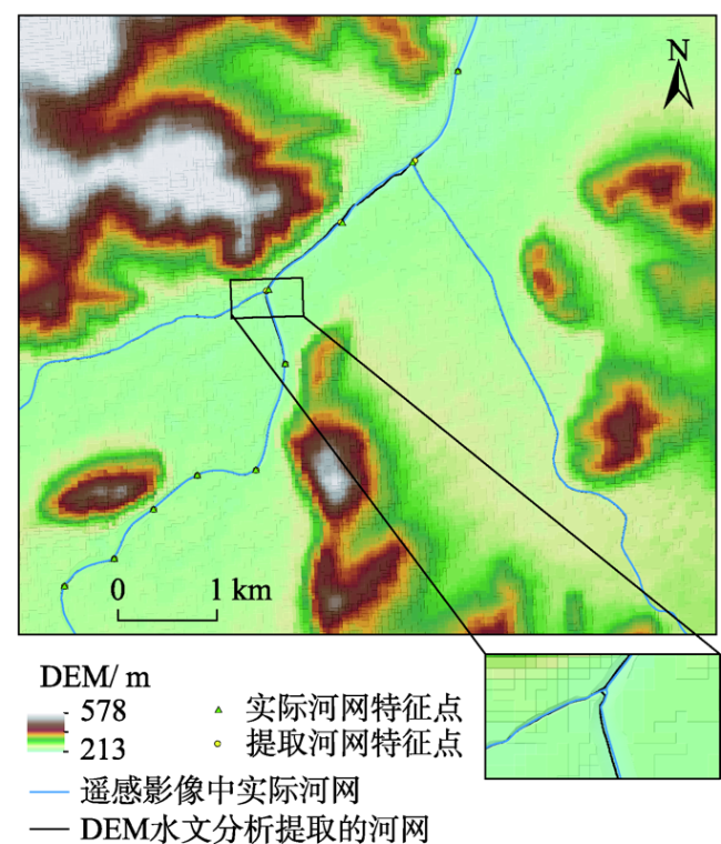
数字高程模型(DEM)包含的信息常作为重要的水文水动力研究基础数据,但是由于公共源DEM数据精度不能完整表达河床地形,所以无法应用于河流泛洪分析等研究工作。因此,本研究开展了基于DEM数据构建数字河床的工作,首先对提取的纵向河网高程数据引入了强局部加权回归算法进行平滑处理以消除畸点;然后以河面要素文件为掩膜,采用反距离加权方法进行横向的空间插值得到3D数字化河面;最后结合河面高程与河深数据完成河床的整体构建。本研究以SRTM DEM为数据地形基础,以位于我国吉林省永吉县境内的温德河为研究实例,对其下游局部区域内的河段重构了矩形、梯形和V型 3种河床断面数字地形。为评价重构数据的合理性,分别对所得到的数字河面进行等值线分析;对河床构建前后DEM水文分析提取的河网进行河道偏移量计算;对构建的地形数据进行河流水动力模拟应用分析,结果表明:① 应用反距离加权插值可以很好地实现河网高程向河面高程的横向延展;② 基于河床重构DEM数据的水文分析误差得到了很好地消除;③ 本研究的重构数据在河流分析中具有较好地应用性和可靠性。
孔乔 , 韩露 , 刘兴坡 , 丁永生 , 王一帆 . 一种采用SRTM DEM重构河床数字地形的方法[J]. 地球信息科学学报, 2021 , 23(3) : 385 -394 . DOI: 10.12082/dqxxkx.2021.190811
Digital Elevation Model (DEM) plays an important role in hydrodynamic researches as an essential data. The resolution of DEM data from public sources is usually not able to depict the riverbed topography. Hence, they cannot be applied to the research work such as river flood analysis. This study carries out the work of digital riverbed construction based on DEM data. Firstly, the longitudinal river network elevation derived from a DEM is smoothed by introducing robust locally weighted regression algorithm to eliminate the abnormal elevation values. Secondly, the cross-sectional interpolation based on the inverse distance weighted method is carried out with the river surface polygon as the mask to acquire the 3D digital river surface. Finally, the overall construction of the riverbed is completed by combining the river surface elevation and river depth data. Based on SRTM DEM, this study took Wende River in Yongji County of Jilin Province as a research example, and constructed three types of digital terrain of riverbed section, i.e., rectangular, trapezoid, and V-shaped, respectively. In order to evaluate the rationality of the data reconstruction, the contour analysis was performed on the obtained digital river surface, and the channel offset of river network extracted from DEM hydrological analyses before and after riverbed reconstruction was also calculated. We finally analyzed the river hydraulic simulation results. Our results show that: (1) the application of inverse distance weighted interpolation can well complete the two-dimensional extension of river network elevation to river surface elevation; (2) the error of hydrological analysis based on reconstructed DEM of riverbed topography was well eliminated; and (3) the reconstruction data in this paper had good applicability and reliability.
Key words: DEM; riverbed; smoothing; reconstruction; interpolation; hydrological analysis; river analysis
表1 实验数据基本信息表Tab. 1 Basic information of experimental data |
| 数据名称 | 数据来源 | 数据格式 | 投影系统 | 坐标系 |
|---|---|---|---|---|
| SRTM1 DEM | 美国地质调查局 (https:// www.usgs.gov/) | GeoTIFF | Universal Transverse Mercator projecting(UTM, Zone 52N) | World Geodetic System 1984(WGS84) |
| 河面矢量数据 | 国家地理信息公共服务平台天地图(https://www.tianditu.gov.cn/) | Shape | ||
| 河网矢量数据 | OSM开放数据源(https://www.openstreetmap.org/) | Shape |
图7 嵌入矩形河床DEM与河网提取结果Fig. 7 SRTM DEM embedded in rectangular digital riverbed and extracted river networks |
图8 嵌入梯形河床DEM与河网提取结果Fig. 8 SRTM DEM embedded in trapezoidal digital riverbed and extracted river networks |
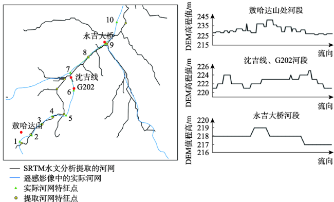
表2 特征点河道偏移量结果及误差Tab. 2 DEM characteristic points’ River Channel Deviation and Errors (m) |
| 特征点编码 | 原始DEM | 矩形河床融合DEM | 梯形河床融合DEM | V形河床融合DEM |
|---|---|---|---|---|
| 1 | 80.90 | 16.11 | 0.31 | 0.26 |
| 2 | 35.97 | 5.66 | 0.06 | 0.16 |
| 3 | 30.30 | 4.73 | 2.16 | 0.15 |
| 4 | 47.31 | 1.88 | 1.17 | 0.02 |
| 5 | 68.61 | 6.83 | 0.09 | 0.38 |
| 6 | 516.65 | 32.81 | 9.93 | 1.36 |
| 7 | 277.69 | 33.90 | 22.78 | 20.89 |
| 8 | 12.13 | 26.58 | 12.38 | 12.10 |
| 9 | 52.96 | 31.92 | 21.87 | 24.16 |
| 10 | 278.79 | 28.97 | 16.15 | 0.00 |
| 平均偏移量 | 140.13 | 18.94 | 8.69 | 5.95 |
| 总体方差 | 24 404.66 | 156.74 | 76.05 | 81.49 |
| 总体标准差 | 156.22 | 12.52 | 8.72 | 9.03 |
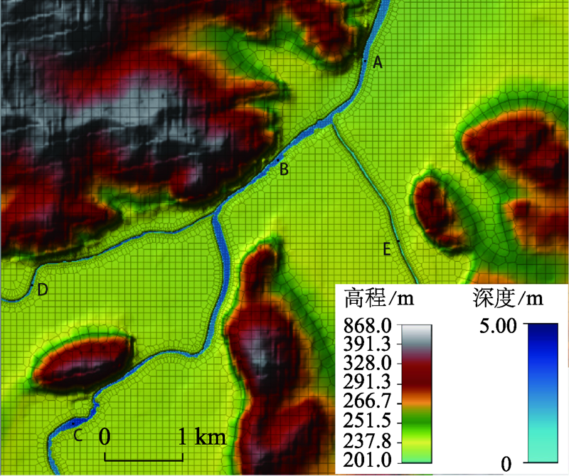
表3 HEC-RAS河流分析中考查点信息Tab. 3 Information of points in HEC-RAS hydrodynamic analysis |
| 点位编码 | A | B | C | D | E |
|---|---|---|---|---|---|
| 坐标 | (126°29′57″E,43°40′29″N) | (126°29′21″E,43°39′56″N) | (126°27′58″E,43°38′33″N) | (126°27′39″E,43°39′16″N) | (126°30′13″E,43°39′32″N) |
| 水深/m | 2.07 | 2.39 | 3.07 | 1.98 | 0.54 |
| 水面高程/m | 215.04 | 218.22 | 225.31 | 223.84 | 223.73 |
| 流速/m.s-1 | 1.83 | 1.55 | 0.59 | 1.02 | 0.52 |
| [1] |
李照会, 郭良, 刘荣华, 等. 基于DEM数字河网提取时集水面积阈值与河源密度关系的研究[J]. 地球信息科学学报, 2018,20(9):1244-1251.
[
|
| [2] |
马永明, 张利华, 张康, 等. 基于SWAT模型和多源DEM数据的流域水系提取精度分析[J]. 地球信息科学学报, 2019,21(10):1527-1537.
[
|
| [3] |
赵远洋, 丁永生, 孙丹, 等. 基于Arcpy编程修正的数字高程模型小流域水文分析[J]. 大连海事大学学报, 2016,42(4):55-60.
[
|
| [4] |
李晶, 张征, 朱建刚, 等. 基于DEM的太湖流域水文特征提取[J]. 环境科学与管理, 2009,34(5):138-142.
[
|
| [5] |
刘佳嘉, 周祖昊, 贾仰文, 等. 河网提取算法中河道断裂现象原因剖析及算法改进[J]. 中国水利水电科学研究院学报, 2013,11(3):195-200.
[
|
| [6] |
郑倩, 史海滨, 李仙岳, 等. 基于AGREE算法与BURN-IN算法的平原灌区DEM河网提取问题剖析[J]. 灌溉排水学报, 2019,38(5):122-128.
[
|
| [7] |
|
| [8] |
彭培, 林爱文. 基于AGREE算法的河流水系提取[J]. 水电能源科学, 2015,33(4):27-29.
[
|
| [9] |
刘佳嘉, 周祖昊, 贾仰文, 等. 河道烧录算法提取出断裂河网的必要条件探究[J]. 水利水电技术, 2015,46(9):21-22,36.
[
|
| [10] |
|
| [11] |
|
| [12] |
|
| [13] |
王光朋, 查小春, 黄春长, 等. HEC-RAS模型在汉江上游洪水演进和流量重建中的应用[J]. 西北农林科技大学学报(自然科学版), 2017,45(12):129-137.
[
|
| [14] |
宁聪, 傅志敏, 王志刚. HEC-RAS模型在二维溃坝洪水研究中的应用[J]. 水利水运工程学报, 2019(2):86-92.
[
|
| [15] |
|
| [16] |
|
| [17] |
郭海燕, 陈军, 徐沅鑫, 等. 径流汇流模拟的河道高程修正方法研究[J]. 干旱气象, 2019,37(4):676-682.
[
|
| [18] |
|
| [19] |
|
| [20] |
俞茜, 陈永灿, 朱德军, 等. 基于DEM数据的河道水动力过程数值模拟[J]. 水力发电学报, 2014,33(3):133-137,157.
[
|
| [21] |
卢敏, 靳甜甜, 尹婧, 等. 少资料河流一维水动力水质模型概化断面参数获取方法[J]. 科技导报, 2017,35(16):74-83.
[
|
| [22] |
戚晓明, 金菊良, 朱兰保, 等. 河道湖泊地形的数字重构研究[J]. 水利水电技术, 2014,45(9):12-14,18.
[
|
| [23] |
|
| [24] |
|
| [25] |
张锦明, 郭丽萍, 张小丹. 反距离加权插值算法中插值参数对DEM插值误差的影响[J]. 测绘科学技术学报, 2012,29(1):51-56.
[
|
| [26] |
唐从国, 刘丛强. 基于Arc Hydro Tools的流域特征自动提取——以贵州省内乌江流域为例[J]. 地球与环境, 2006(3):30-37.
[
|
| [27] |
马珊, 刘昌军, 何秉顺, 等. 温德河流域暴雨洪水时空特征及模拟分析[J]. 水利水电技术, 2019,50(6):78-84.
[
|
| [28] |
要志斌, 周研, 王荣军, 等. 激光轮廓检测技术在镁合金管大曲率热弯工艺中的应用[J]. 热加工工艺, 2019(21):21.
[
|
| [29] |
胡海松, 罗居刚, 邰洪生, 等. 不同断面形状的河段对整体河道水力特性影响研究[J]. 水利科学与寒区工程, 2018,1(10):19-22.
[
|
/
| 〈 |
|
〉 |

