
地缘经济背景下泰国及其毗邻国家边境农业扩张与集约化抵边特征
|
冯京辉(1996-),女,陕西延安人,硕士生,主要从事边境土地利用研究。E-mail: fjh612@126.com |
收稿日期: 2020-06-15
要求修回日期: 2020-07-31
网络出版日期: 2021-05-25
基金资助
国家自然科学基金项目(41971242)
国家自然科学基金项目(42001226)
中国科学院地理科学与资源研究所“秉维”优秀青年人才计划(2018RC201)
中国科学院青年创新促进会会员人才专项(CAS2020055)
版权
Border-prone Characteristics of Agricultural Expansion and Intensification in the Borders of Thailand and its Neighboring Countries (Cambodia, Laos and Myanmar) Under the Context of Geo-Economy
Received date: 2020-06-15
Request revised date: 2020-07-31
Online published: 2021-05-25
Supported by
National Natural Science Foundation of China(41971242)
National Natural Science Foundation of China(42001226)
Program for BINGWEI Excellent Young Talents of Institute of Geographic Sciences and Natural Resources Research, Chinese Academy of Sciences(2018RC201)
Youth Innovation Promotion Association of the Chinese Academy of Sciences(CAS2020055)
Copyright
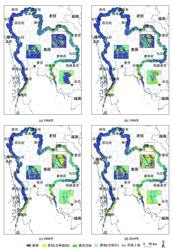
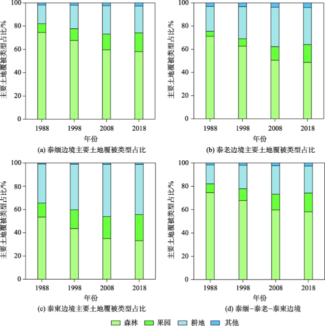
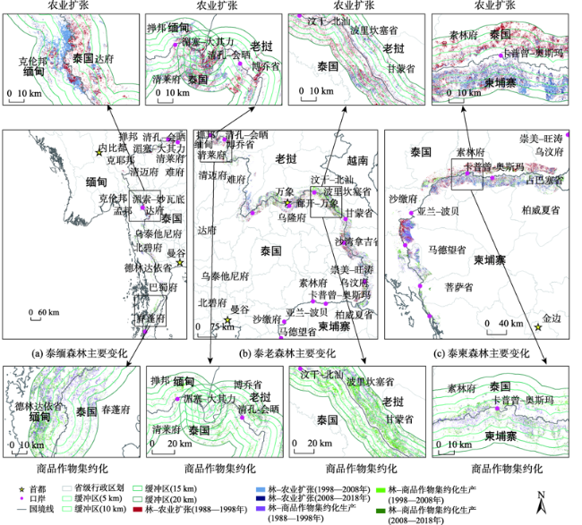
自泰国总理差猜1988年提出“变印支战场为市场”倡议以来,泰国与毗邻国家(缅、老和柬)的地缘关系由政治阻隔转向经济合作,并在其边境(尤其是口岸)引发不同程度的土地覆被/利用变化。利用美国国际开发署SERVIR-Mekong项目土地覆被产品,基于GIS空间分析对泰缅、泰老和泰柬边境地带(国界线两侧20 km缓冲区)1988、1998、2008、2018年的土地覆被现状及其时空变化、以及因农业扩张与集约化引起森林变化的抵边/离边、趋同/趋异特征进行了定量研究与国别对比。结果表明:① 森林、耕地和果园是3条边境主要土地覆被类型,土地占比超过96%,其中森林因农业扩张与集约化而持续减少。② 农业扩张与集约化引起的森林转换时空特征显著,即泰缅、泰老边境于1998—2008年在湄索(泰)-妙瓦底(缅)口岸、汶干(泰)-北汕(老)口岸附近及“金三角”地区较为剧烈,泰柬边境则在1988—1998年内于卡普曾(泰)-奥斯玛(柬)口岸周边较为突出,土地占比超七成。③ 边境地区农业扩张与集约化引起的森林变化具有明显的抵边/离边、趋同/趋异特征。农业扩张所致森林变化在泰老边境由同向变化转为反向趋异,在泰缅边境两侧由强抵边转为在缅一侧抵边更为明显,在泰柬边境主要表现为先抵边后离边再抵边。集约化生产所致森林变化在泰老边境表现为泰国一侧抵边更强,在泰缅缅甸一侧为离边到抵边,在泰柬边境两侧主要为反向抵边。④ 边境森林变化的抵边/离边、趋同/趋异特征分析表明,泰国对老挝的影响最大,柬埔寨次之,缅甸最次。本研究可为从地理学空间视角研究边境土地利用与地缘经济关系交叉互动提供启发。
冯京辉 , 李鹏 , 肖池伟 , 祁月基 , 李霞 . 地缘经济背景下泰国及其毗邻国家边境农业扩张与集约化抵边特征[J]. 地球信息科学学报, 2021 , 23(3) : 479 -491 . DOI: 10.12082/dqxxkx.2021.200306
Since the implementation of the initiative of “Turning the Battlefields into Marketplaces” by Thai Prime Minister Chatichai Choonhavan in 1988, the relation between Thailand and its neighboring countries (including Cambodia, Laos and Myanmar) has shifted from political isolation to economic cooperation, which leads to varying degrees of land cover / use changes in the border areas (particularly the border crossings). With the land cover data products gathered from the US Agency for International Development's SERVIR-Mekong project, the status of land cover types and their spatial and temporal changes were quantitatively analyzed and compared between different countries using GIS-based spatial analysis, followed by the characteristics analyses of bordering and off-bordering, convergence and divergence of forest cover dynamics due to agricultural expansion (increased cropland) and cash-crops intensification (increased orchard or plantation) within the 20-km buffer areas of Thailand-Myanmar, Thailand-Laos, and Thailand-Cambodia borders in 1988, 1998, 2008, and 2018. The results show that: (1) Forests, cropland, and orchards (including plantations) were the main types of land cover in the border areas of Thailand, Myanmar, Laos, and Cambodia in the past decades, accounting for over 96%. An overall decrease of forests was also seen because of agricultural expansion and intensive production of commercial crops. (2) The forests conversion had obvious spatial and temporal features. Extensive forest transformations occurred in the neighborhood area of the border crossings of Mae Sot (Thailand)-Myawady (Myanmar) and Bueng Kan (Thailand)-Paksan (Laos) as well as the “Golden Triangle” area among Thailand, Myanmar, and Laos during 1998-2008. Similar transitions were also observed in the neighborhood area of the border crossings of Kap Choeng (Thailand)-Osmach(Cambodia) from 1988 to 1998, accounting for more than 70%. (3) Agricultural expansion and cash-crops intensification showed obvious characteristics of bordering and off-bordering, convergence and divergence in the border areas. Specifically, the forest changes caused by agricultural expansion has changed from the same to opposite direction showing divergence in the Thai-Lao border, from bilateral stronger bordering to unilateral bordering in the Myanmar side along the Thai-Burmese border, and from bordering to off-bordering and back to bordering in the Thai-Cambodian border. The forest changes caused by intensive production showed stronger bordering in the Thai-side of Thai-Lao border, from off-bordering to bordering in the Burmese side of Thai-Myanmar border, and bilateral opposite bordering of Thai-Cambodian border. (4) Bordering characteristics analysis of forest change indicated that Thailand had the greatest geo-influence on Laos, followed by Cambodia and Myanmar. Our study contributes to further investigating the cross-interaction between border land use and geo-economic relations from the perspective of spatial difference in Geography.
图5 1988-2018年泰缅、泰老、泰柬边境地区农业扩张与集约化生产空间变化注:该图基于自然资源部标准地图服务网站下载的审图号为GS(2016)2948号的标准地图制作,底图无修改。 Fig. 5 Spatial changes in agricultural expansion and intensification transformed from forest in the 20-km border areas of Thailand-Myanmar, Thailand-Laos, and Thailand-Cambodia borders from 1988 to 2018 |
表1 1988-2018年泰缅、泰老、泰柬边境地区林-耕(农业扩张)面积变化Tab. 1 Area changes in forest-to-cropland (agricultural expansion) in the 0~5, 5~10, 10~15 and 15~20 km border areas of Thailand-Myanmar, Thailand-Laos, and Thailand-Cambodia borders from 1988 to 2018 (km2) |
| 林-耕(农业扩张)面积变化 | 泰老边境 | 泰缅边境 | 泰柬边境 | |||||
|---|---|---|---|---|---|---|---|---|
| 泰国一侧 | 老挝一侧 | 泰国一侧 | 缅甸一侧 | 泰国一侧 | 柬埔寨一侧 | |||
| 1988-1998年(0~5 km) | 380 | 352 | 175 | 108 | 65 | 194 | ||
| 1988-1998年(5~10 km) | 522 | 282 | 137 | 48 | 151 | 163 | ||
| 1988-1998年(10~15 km) | 573 | 242 | 92 | 36 | 195 | 122 | ||
| 1988-1998年(15~20 km) | 593 | 229 | 98 | 32 | 205 | 89 | ||
| 1998-2008年(0~5 km) | 405 | 454 | 133 | 252 | 37 | 161 | ||
| 1998-2008年(5~10 km) | 540 | 503 | 100 | 129 | 72 | 241 | ||
| 1998-2008年(10~15 km) | 557 | 484 | 80 | 81 | 88 | 278 | ||
| 1998-2008年(15~20 km) | 574 | 382 | 106 | 58 | 90 | 196 | ||
| 2008-2018年(0~5 km) | 46 | 79 | 22 | 57 | 3 | 71 | ||
| 2008-2018年(5~10 km) | 900 | 88 | 17 | 42 | 3 | 82 | ||
| 2008-2018年(10~15 km) | -790 | 78 | 15 | 28 | 5 | 78 | ||
| 2008-2018年(15~20 km) | 56 | 61 | 19 | 18 | 6 | 59 | ||
表2 1988-2018年泰缅、泰老、泰柬边境地区林-园(商品作物集约化生产)面积变化Tab. 2 Area changes in forest-to-orchard (intensive production of commercial crops) in the 0~5, 5~10, 10~15 and 15~20 km border areas of Thailand-Myanmar, Thailand-Laos, and Thailand-Cambodia borders from 1988 to 2018 (km2) |
| 林-园(商品作物集约化生产)面积变化 | 泰老边境 | 泰缅边境 | 泰柬边境 | |||||
|---|---|---|---|---|---|---|---|---|
| 泰国一侧 | 老挝一侧 | 泰国一侧 | 缅甸一侧 | 泰国一侧 | 柬埔寨一侧 | |||
| 1988-1998年(0~5 km) | 91 | 234 | 130 | 146 | 89 | 171 | ||
| 1988-1998年(5~10 km) | 100 | 243 | 135 | 204 | 42 | 171 | ||
| 1988-1998年(10~15 km) | 87 | 282 | 136 | 222 | 47 | 154 | ||
| 1988-1998年(15~20 km) | 64 | 257 | 48 | 142 | 145 | 260 | ||
| 1998-2008年(0~5 km) | 405 | 454 | 133 | 252 | 37 | 161 | ||
| 1998-2008年(5~10 km) | 258 | 350 | 120 | 234 | 58 | 95 | ||
| 1998-2008年(10~15 km) | 241 | 331 | 124 | 248 | 73 | 67 | ||
| 1998-2008年(15~20 km) | 179 | 370 | 125 | 265 | 64 | 77 | ||
| 2008-2018年(0~5 km) | 74 | 111 | 41 | 50 | 26 | 52 | ||
| 2008-2018年(5~10 km) | 377 | 112 | 44 | 51 | 15 | 34 | ||
| 2008-2018年(10~15 km) | -219 | 107 | 44 | 44 | 15 | 22 | ||
| 2008-2018年(15~20 km) | 61 | 103 | 46 | 43 | 15 | 27 | ||
| [1] |
陆大道, 杜德斌. 关于加强地缘政治地缘经济研究的思考[J]. 地理学报, 2013,68(6):723-727.
[
|
| [2] |
全毅, 尹竹. 中国—东盟区域、次区域合作机制与合作模式创新[J]. 东南亚研究, 2017(6):15-36.
[
|
| [3] |
黎鹏. 提升沿边开放与加强跨国区域合作研究——以CAFTA背景下中国西南边境跨国区域为例[M]. 北京: 经济科学出版社, 2012.
[
|
| [4] |
李秋萍, 陆汝成, 李冠, 等. 边境土地利用变化及其与贸易发展互动关系研究进展[J]. 中国土地科学, 2015,29(8):16-23.
[
|
| [5] |
宋周莺, 车姝韵, 王姣娥, 等. 中国沿边口岸的时空格局及功能模式[J]. 地理科学进展, 2015,34(5):589-597.
[
|
| [6] |
|
| [7] |
Achim, Röder, Michael, et al. Assessing urban growth and rural land use transformations in a cross-border situation in Northern Namibia and Southern Angola[J]. Land Use Policy, 2015,42:340-354.
|
| [8] |
|
| [9] |
|
| [10] |
|
| [11] |
|
| [12] |
|
| [13] |
|
| [14] |
|
| [15] |
李鹏, 封志明. 地缘经济背景下的老挝橡胶林地扩张监测及其影响研究综述[J]. 地理科学进展, 2016,35(3):286-294.
[
|
| [16] |
|
| [17] |
|
| [18] |
廖谌婳, 封志明, 李鹏, 等. 缅老泰交界地区刀耕火种农业的时空变化格局[J]. 地理研究, 2014,33(8):1529-1541.
[
|
| [19] |
邓强, 苏志军. 为民治土为国固边——基于国土安全的中越边境地区土地利用思路研究[J]. 中国土地, 2013(8):21-23.
[
|
| [20] |
|
| [21] |
李秋萍, 陆汝成, 梁宝坤, 等. 广西陆地边境地区土地利用信息图谱构建[J]. 水土保持研究, 2016,23(6):210-215.
[
|
| [22] |
肖池伟, 饶滴滴, 刘怡媛, 等. 地缘经济合作背景下的中国磨憨—老挝磨丁口岸地区建设用地扩张[J]. 地球信息科学学报, 2019,21(10):1576-1585.
[
|
| [23] |
|
| [24] |
|
| [25] |
|
| [26] |
周明伟. 差猜政府的“变印支战场为商场”政策[J]. 南洋问题研究, 1990(4):55-63.
[
|
| [27] |
陈红升. 泰国:2008—2009年回顾与展望[J]. 东南亚纵横, 2009(3):27-32.
[
|
| [28] |
胡超. 边境地区开发开放的国际经验与启示—兼论“一带一路”倡议下我国边境地区的开发开放[J]. 边界与海洋研究, 2018,3(3):78-91.
[
|
| [29] |
|
| [30] |
罗伯特·库伯. 《文化震撼之旅——泰国》[M]. 北京: 旅游教育出版社, 2008.
[
|
| [31] |
国务院关于边境贸易有关问题的通知[J]. 对外经贸财会, 1996(3):45-46.
[ Notice of the State Council on Issues Related to Border Trade[J]. Foreign Economic Relations,Trade and Accounting, 1996(3):45-46. ]
|
| [32] |
FAO. Irrigation in Southern and Eastern Asia in figures, AQUASTAT Survey:Thailand. FRA2011:1-13(Rome).
|
| [33] |
|
| [34] |
|
| [35] |
陈百明, 周小萍. 《土地利用现状分类》国家标准的解读[J]. 自然资源学报, 2007,22(6):994-1003.
[
|
/
| 〈 |
|
〉 |
