
CSD和CDD结合下的最优遥感特征指数集构建及其在湿地信息提取中的应用
|
赵栋梁(1996— ),男,山西吕梁人,硕士生,主要事从湿地生态过程研究。E-mail: 920240936@qq.com |
收稿日期: 2020-05-17
要求修回日期: 2020-12-09
网络出版日期: 2021-08-25
基金资助
北京市自然科学基金和北京市教委联合资助重点项目(KZ20190028042)
版权
Construction of Optimal Remote Sensing Feature Index Set based on CSD and CDD and Its Application in Wetland Information Extraction
Received date: 2020-05-17
Request revised date: 2020-12-09
Online published: 2021-08-25
Supported by
Natural Science Foundation of Beijing and Education Commission of Beijing(KZ20190028042)
Copyright
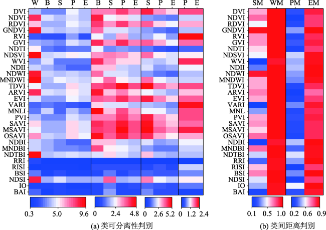
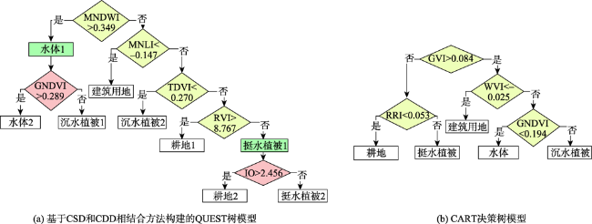
依托中分辨率成像光谱仪完整的数据序列和丰富的光谱信息,遥感特征指数在湿地生态系统发展变化的状态、趋向和规律研究方面发挥着不可替代的优势。传统类间距离判别的遥感特征指数选取中常存在过分依赖数据统计特征、入选指数与目标地类间生态学意义不明确、分类模型普适性差等局限性。基于此,本研究以河北省白洋淀湿地自然保护区为例,提出类可分离性距离判别(Class Separation Discrimination,CSD)与类间距离判别(Class Distance Discrimination,CDD)相结合的方法构建最优遥感特征指数集,并采用QUEST算法和马氏距离判别法构建分类决策树模型用于白洋淀湿地信息的提取研究,尝试克服传统类间距离指数选取中的不足。结果表明:运用CSD和CDD相结合的方法所选取的遥感特征指数在研究区湿地信息提取过程中的总体分类精度达到了91.32%,Kappa系数0.88,较传统的分类与回归树(Classification and Regression Tree,CART)方法,分类精度提高了1.67%;其次选取的最优指数与待提取的湿地类型均具有明确的生态学意义,如挺水植物在立地干湿交替条件下的潴育化过程决定了氧化铁比率IO可成功的将混分的耕地和挺水植物进一步分离;进一步将基于研究区2017年OLI影像构建的CSD和CDD相结合方法与CART方法的模型分别应用于研究区2019年OLI影像进行分类,基于CSD和CDD相结合方法构建的模型分类总体精度和Kappa系数分别为:86.97%、0.83,基于CART方法构建的模型无法满足分类需求,研究结果较好地证明了基于CSD和CDD相结合方法构建的模型在年际之间具有良好的适用性和稳定性。总之,CSD和CDD相结合的方法在不降低湿地信息提取精度的基础上,有效避免了传统遥感特征指数选择方法的局限性,提高了分类模型的普适性,是遥感特征指数选择算法和决策树相结合在湿地信息提取方面的有益尝试。
赵栋梁 , 郭超凡 , 吴东丽 , 高星琪 , 郭逍宇 . CSD和CDD结合下的最优遥感特征指数集构建及其在湿地信息提取中的应用[J]. 地球信息科学学报, 2021 , 23(6) : 1092 -1105 . DOI: 10.12082/dqxxkx.2021.200517
Based on the complete data sequence and abundant spectral information of the moderate resolution imaging spectrometer, remote sensing feature indices play an irreplaceable role in studying the stage, trend, and law of wetland ecosystem development. There are some limitations in selection of remote sensing feature indices for the traditional inter-class distance discrimination, such as over-dependence on statistical characteristics of data, indefiniteness of the inclusion index and the ecological significance of the target area, and poor applicability of the classification model. Based on this, Baiyangdian Wetland Nature Reserve in Hebei Province is selected as the research area. The method of Class Separation Discrimination (CSD) and Class Distance Discrimination (CDD) is proposed to construct the optimal remote sensing feature index. In addition, QUEST algorithm and Markov distance discrimination method are used to construct the classification decision tree model for the Baiyangdian Wetland extraction, which overcomes the shortcomings in the selection of traditional inter-class distance index. The results show that, firstly, the overall classification accuracy of the remote sensing feature index selected by the method combining CSD and CDD reach 91.32% and the kappa coefficient is 0.88 for the wetland information extraction in the study area. Compared with the traditional Classification and Regression Tree (CART) method, the classification accuracy is improved by 1.67%. Secondly, the selected optimal remote sensing feature index has a clear ecological meaning for the type of wetland extracted. For example, the redoxing process of emergent water plants under alternate dry and wet conditions determines that iron oxide index (IO) can be successfully selected to further separate the mixed cultivated land and emergent water plants. Furthermore, according to the OLI image of the study area in 2017, the decision tree model based on the combination of CSD and CDD and the decision tree model based on CART algorithm are applied to the classification of the OLI image in the study area in 2019. The overall classification accuracy and kappa coefficient of the model based on the combination of CSD and CDD are 86.97% and 0.83, respectively. The model based on cart method cannot meet the classification requirements. The research results show that the model based on the combination of CSD and CDD has good applicability and stability over years. In a word, the combination of CSD and CDD can effectively avoid the limitations of traditional remote sensing feature indices, and improve the applicability of classification model. It is a beneficial attempt to combine remote sensing feature index selection algorithm with decision tree in wetland information extraction.
表1 Landsat8_OLI获取时间Tab. 1 Acquisition time of Landsat8_OLI |
| 影像编号 | 获取日期 | 获取卫星 | 分辨率/m | 行列号 | 影像质量 |
|---|---|---|---|---|---|
| A | 2017-09-28 | Landsat8_OLI | 30 | 123/33 | 良好 |
| B | 2019-09-18 | Landsat8_OLI | 30 | 123/33 | 良好 |
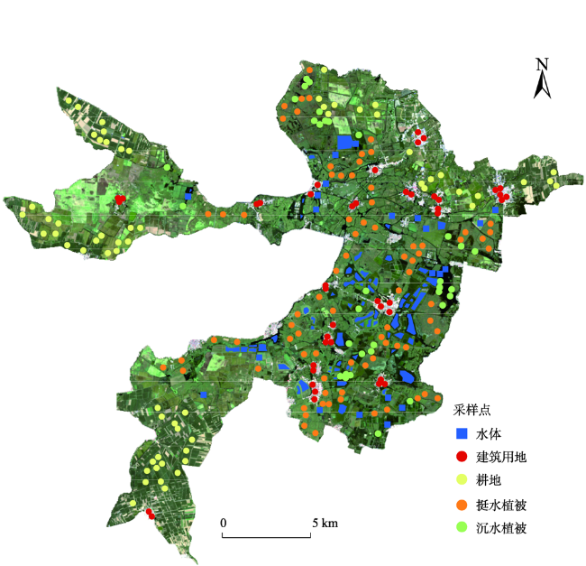
表2 白洋淀湿地分类方案Tab. 2 Classification scheme of Baiyangdian wetland |
| 一级分类 | 二级分类 | 三级分类 | 说明 |
|---|---|---|---|
| 湿地 | 水体 | 主要有河流、湖泊、水库、沟渠、鱼塘等 | |
| 水生植被 | 挺水植被 | 主要指芦苇、香蒲和莲等植物 | |
| 沉水植被 | 主要指狐尾藻、金鱼藻、马来眼子菜、篦齿眼子菜等植物 | ||
| 非湿地 | 耕地 | 主要有水稻、小麦、玉米等农作物 | |
| 建筑用地 | 主要指包括城镇、乡村、工矿、交通等各类建设用地 |
表3 遥感特征指数集Tab. 3 Remote sensing feature index set |
| 特征类 | 遥感特征指数 | 简称 | 计算方法 | 参考文献 |
|---|---|---|---|---|
| 绿度指数 | 差值植被指数 | DVI | NIR-Red | [25] |
| 归一化差值植被指数 | NDVI | (NIR-Red)/(NIR+Red) | [26] | |
| 重归一化植被指数 | RDVI | (NIR-Red)/(SQRT(NIR+Red)) | [27] | |
| 绿色归一化植被指数 | GNDVI | (NIR-Green)/(NIR+Green) | [28] | |
| 比值植被指数 | RVI | NIR/Red | [29] | |
| 缨帽变换绿度分量 | GVI | (-0.2848)×Blue+(-0.2435)×Green+(-0.5436)×Red+(0.7243)×NIR+(0.0840)×SWIR_1+(-0.1800)×SWIR_2 | [30] | |
| 黄度指数 | 归一化差值耕作指数 | NDTI | (SWIR_1-SWIR_2)/(SWIR_1+SWIR_2) | [31] |
| 归一化衰败植被指数 | NDSVI | (SWIR_1-Red)/(SWIR_1+Red) | [32] | |
| 消除大气影响的植被指数 | 转换差值植被指数 | TDVI | 1.5×(NIR-Red)/SQRT(NIR 2+Red 2+0.5) | [33] |
| 大气阻抗植被指数 | ARVI | (NIR-(2×Red-Blue))/(NIR+(2×Red-Blue)) | [34] | |
| 增强型植被指数 | EVI | 2.5×((NIR-Red)/(NIR+6×Red-7.5×Blue+1)) | [35] | |
| 可见光大气阻抗指数 | VARI | (Green-Red)/(Green+Red-Blue) | [36] | |
| 消除土壤背景影像的植被 指数 | 修改型非线性植被指数 | MNLI | ((NIR2-Red) (1+0.5))/(NIR2+Red+0.5) | [37] |
| 垂直植被指数 | PVI | (NIR-0.96916×Red-0.084726)/SQRT (1+0.969162) | [38] | |
| 土壤调节植被指数 | SAVI | 1.5×(NIR-Red)/(NIR+Red+0.5) | [39] | |
| 修改型土壤调节植被 指数 | MSAVI | 0.5×(2×NIR+1-SQRT((2×NIR+1)2)-8×(NIR-Red))) | [40] | |
| 优化土壤调节植被指数 | OSAVI | (NIR-Red)/(NIR+Red+0.16) | [41] | |
| 湿度指数 | 缨帽变换湿度分量 | WVI | (0.1509)×Blue+0.1973×Green+0.3279×Red+0.3406×NIR-0.7112×SWIR_1-0.4572×SWIR_2 | [30] |
| 归一化红外指数 | NDII | (NIR-SWIR_1)/(NIR+SWIR_1) | [42] | |
| 归一化差异水体指数 | NDWI | (Green-NIR)/(Green+NIR) | [43] | |
| 改进的归一化差异水体指数 | MNDWI | (Green-SWIR_1)/(Green-SWIR_1) | [3] | |
| 建筑指数 | 归一化建筑指数 | NDBI | (SWIR_1-NIR)/(SWIR_1-NIR) | [5] |
| 改进的归一化裸露指数 | MNDBI | NDBI+(1-NDVI) | [44] | |
| 归一化三波段指数 | NDTBI | (SWIR_2+SWIR_1-Red)/(SWIR_2+SWIR_1+Red) | [45] | |
| 比值居民地指数 | RRI | Blue/NIR | [46] | |
| 比值不透水面指数 | RISI | (SWIR_1-SWIR_2)/Blue | [47] | |
| 土壤指数 | 裸土指数 | BSI | ((SWIR_1+Red) -(NIR+Blue))/((SWIR_1+Red) +(NIR+Blue)) | [48] |
| 归一化土壤指数 | NDSI | (SWIR_2-Green)/(SWIR_2+Green) | [49] | |
| 氧化铁比率指数 | IO | Red/Blue | [50] | |
| 燃烧面积指数 | BAI | 1/((0.1-Red)2+(0.06-NIR)2)) | [51] |
注:Blue、Green、Red、NIR、SWIR_1和SWIR_2分别表示Landsat8_OLI传感器中蓝、绿、红、近红外、短波红外1和短波红外2波段的反射率。 |
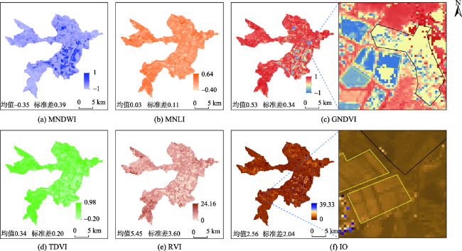
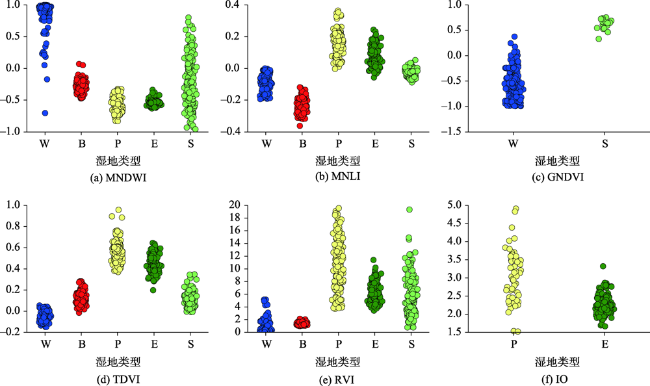
图5 基于CSD和CDD相结合选出的遥感特征指数空间分布注:图(c)中黄色框为水体,黑色框为沉水植被;图(f)中黄色框为耕地,黑色框为挺水植被。 Fig. 5 Spatial distribution of remote sensing feature index selected based on combination of CSD and CDD |
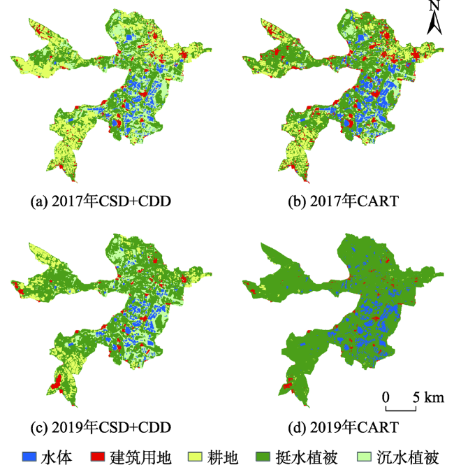
表4 基于CSD和CDD相结合与CART方法的白洋淀湿地分类精度Tab. 4 Baiyangdian wetland classification accuracy of combination of CSD and CDD or CART method |
 白洋淀湿地类型 白洋淀湿地类型 | 2017年CSD+CDD | 2017年CART | 2019年CSD+CDD | 2019年CART | ||||
|---|---|---|---|---|---|---|---|---|
| 用户精度/% | 制图精度/% | 用户精度/% | 制图精度/% | 用户精度/% | 制图精度/% | 用户精度/% | 制图精度/% | |
| 水体 | 93.37 | 75.52 | 86.05 | 99.02 | 98.96 | 78.77 | 83.02 | 87.04 |
| 建设用地 | 94.90 | 96.47 | 99.09 | 80.91 | 99.59 | 94.21 | 99.30 | 62.81 |
| 耕地 | 96.48 | 92.43 | 72.77 | 77.74 | 97.07 | 78.53 | 99.61 | 6.63 |
| 挺水植被 | 88.42 | 95.21 | 99.39 | 93.22 | 75.74 | 96.97 | 45.66 | 100.00 |
| 沉水植被 | 71.80 | 86.22 | 83.18 | 86.76 | 72.43 | 88.32 | 0 | 0 |
| 总体精度/% | 91.32 | 89.65 | 86.97 | 56.21 | ||||
| Kappa系数 | 0.88 | 0.86 | 0.83 | 0.37 | ||||
| [1] |
嘎力巴. 基于遥感指数地物信息提取方法对比研究[D]. 哈尔滨:哈尔滨师范大学, 2017.
[A comparative study on the extraction method of surface features based on remote sensing index[D]. Harbin: Normal University, 2017. ]
|
| [2] |
李喆, 胡蝶, 赵登忠, 等. 宽波段遥感植被指数研究进展综述[J]. 长江科学院院报, 2015,32(1):125-130.
[
|
| [3] |
徐涵秋. 利用改进的归一化差异水体指数(MNDWI)提取水体信息的研究[J]. 遥感学报, 2005(5):589-595.
[
|
| [4] |
徐涵秋. 城市遥感生态指数的创建及其应用[J]. 生态学报, 2013,33(24):7853-7862.
[
|
| [5] |
查勇, 倪绍祥, 杨山. 一种利用TM图像自动提取城镇用地信息的有效方法[J]. 遥感学报, 2003,7(1):37-40,82.
[
|
| [6] |
贾坤, 姚云军, 魏香琴, 等. 植被覆盖度遥感估算研究进展[J]. 地球科学进展, 2013,28(7):774-782.
[
|
| [7] |
吴志杰, 邹丹, 黄绍霖. 山地城市扩展及生态变化遥感分析[J]. 亚热带资源与环境学报, 2016,11(3):81-87,94.
[
|
| [8] |
佟光臣, 林杰, 陈杭, 等. 1994—2014年连云港市赣榆区生态变化评估[J]. 水土保持研究, 2016,23(6):352-357.
[
|
| [9] |
那晓东, 张树清, 孔博, 等. 基于决策树方法的淡水沼泽湿地信息提取——以三江平原东北部为例[J]. 遥感技术与应用, 2008(4):365-372,355.
[
|
| [10] |
雷璇, 杨波, 蒋卫国, 等. 东洞庭湿地植被格局变化及其影响因素[J]. 地理研究, 2012,31(3):461-470.
[
|
| [11] |
孟超, 王计平, 支晓蓉, 等. 基于GIS的县域森林景观空间格局等级特征研究[J]. 农业机械学报, 2018,49(10):187-194,204.
[
|
| [12] |
许明明, 张良培, 杜博, 等. 基于类别可分性的高光谱图像波段选择[J]. 计算机科学, 2015,42(4):274-275,296.
[
|
| [13] |
孙滨峰, 赵红, 陈立才, 等. 基于植被指数选择算法和决策树的生态系统识别[J]. 农业机械学报, 2019,50(6):194-200.
[
|
| [14] |
林川, 宫兆宁, 赵文吉. 基于中分辨率TM数据的湿地水生植被提取[J]. 生态学报, 2010,30(23):6460-6469.
[
|
| [15] |
李行, 毛定山, 张连蓬. 高光谱遥感影像波段选择算法评价方法研究[J]. 地理与地理信息科学, 2006,22(6):34-37.
[
|
| [16] |
王京, 卢善龙, 吴炳方, 等. 近40年来白洋淀湿地土地覆被变化分析[J]. 地球信息科学学报, 2010,12(2):2292-2300.
[
|
| [17] |
江波, 陈媛媛, 肖洋, 等. 白洋淀湿地生态系统最终服务价值评估[J]. 生态学报, 2017,37(8):2497-2505.
[
|
| [18] |
刘茂峰, 高彦春, 甘国靖. 白洋淀流域年径流变化趋势及气象影响因子分析[J]. 资源科学, 2011,33(8):1438-1445.
[
|
| [19] |
张敏, 宫兆宁, 赵文吉, 等. 近30年来白洋淀湿地景观格局变化及其驱动机制[J]. 生态学报, 2016,36(15):4780-4791.
[
|
| [20] |
刘俊国, 赵丹丹, 叶斌. 雄安新区白洋淀生态属性辨析及生态修复保护研究[J]. 生态学报, 2019,39(9):3019-3025.
[
|
| [21] |
张磊, 宫兆宁, 王启为, 等. Sentinel-2影像多特征优选的黄河三角洲湿地信息提取[J]. 遥感学报, 2019,23(2):313-326.
[
|
| [22] |
全国湿地资源调查与监测技术规程[M]. 中华人民共和国国家林业局, 2001.
[ Technical specification for national wetland resources investigation and monitoring[M]. State Forestry Administration of the people's Republic of China, 2001. ]
|
| [23] |
王雪宏, 栗云召, 孟焕, 等. 黄河三角洲新生湿地植物群落分布格局[J]. 地理科学, 2015,35(8):1021-1026.
[
|
| [24] |
梅安新. 遥感导论[M]. 北京: 高等教育出版社, 2001.
[
|
| [25] |
|
| [26] |
|
| [27] |
|
| [28] |
|
| [29] |
|
| [30] |
|
| [31] |
|
| [32] |
|
| [33] |
|
| [34] |
|
| [35] |
|
| [36] |
|
| [37] |
|
| [38] |
|
| [39] |
|
| [40] |
|
| [41] |
|
| [42] |
|
| [43] |
|
| [44] |
吴宏安, 蒋建军, 周杰, 等. 西安城市扩张及其驱动力分析[J]. 地理学报, 2005,60(1):143-150.
[
|
| [45] |
饶萍, 王建力, 王勇. 基于多特征决策树的建设用地信息提取[J]. 农业工程学报, 2014,30(12):233-240.
[
|
| [46] |
吴宏安, 蒋建军, 张海龙, 等. 比值居民地指数在城镇信息提取中的应用[J]. 南京师范大学报(自然科学版), 2006,29(3):118-121.
[
|
| [47] |
尹毅, 黄哲. 天水市不透水表面提取及时空变化分析[J]. 安徽农业科学, 2013,41(29):11893-11895.
[
|
| [48] |
晓琴, 孙丹峰, 张凤荣. 基于遥感的北京山区植被覆盖景观格局动态分析[J]. 山地学报, 2003,21(3):272-280.
[
|
| [49] |
RNDSI: A ratio normalized difference soil index for remote sensing of urban/suburban environments[J]. International Journal of Applied Earth Observations & Geoinformation, 2015,39:40-48.
|
| [50] |
|
| [51] |
|
| [52] |
那晓东, 张树清, 李晓峰, 等. 基于QUEST决策树兼容多源数据的淡水沼泽湿地信息提取[J]. 生态学杂志, 2009,28(2):357-365.
[
|
| [53] |
吴健生, 潘况一, 彭建, 等. 基于QUEST决策树的遥感影像土地利用分类——以云南省丽江市为例[J]. 地理研究, 2012,31(11):1973-1980.
[
|
| [54] |
|
| [55] |
张甘霖, 龚子同. 氧化还原形态特征模式与形成机理解析[J]. 土壤学进展, 1994,22(3):54-56.
[
|
| [56] |
朱金峰, 周艺, 王世新, 等. 1975—2018年白洋淀湿地变化分析[J]. 遥感学报, 2019,23(5):971-986.
[
|
/
| 〈 |
|
〉 |
