
基于离散粒子群算法的2种新型水体提取方法的对比与验证
|
李志红(1996— ),女,甘肃白银人,硕士生,主要从事3S技术及应用研究。E-mail: 1824316193@qq.com |
收稿日期: 2020-09-16
要求修回日期: 2021-01-06
网络出版日期: 2021-08-25
基金资助
国家自然科学基金项目(41601066)
甘肃省自然科学基金项目(20JR5RA444)
版权
Comparison and Verification of Two New Lake Water Extraction Methods based on Discrete Particle Swarms Optimization Algorithm
Received date: 2020-09-16
Request revised date: 2021-01-06
Online published: 2021-08-25
Supported by
National Natural Science Foundation of China(41601066)
Natural Science Foundation of Gansu province, China(20JR5RA444)
Copyright
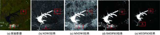
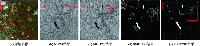
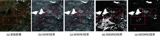
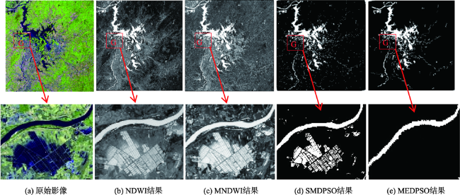
随着遥感技术在水体提取与监测方面的广泛应用,更多的研究者致力于提高遥感水体提取的精度。离散粒子群算法在遥感图像分类研究中获得了较高的精度和更稳健的分类效果,已经被应用到遥感水体提取领域,但其在水体提取中的适用性和精度还有待对比与验证。本文采用最新提出的2种基于离散粒子群算法的水体提取方法,即光谱匹配耦合离散粒子群算法(SMDPSO)与最大熵耦合离散粒子群算法(MEDPSO),基于Landsat8_OLI遥感影像,分别选择了有冰雪、有云、有山体阴影和有建筑物的4种环境复杂,常规方法提取精度较低的区域进行水体提取,并与2种常用的水体指数法(NDWI、MNDWI)进行了对比与验证。结果表明:① SMDPSO和MEDPSO方法在4个实验区都能快速地寻找出最佳的水体分布,具有一定的通用性;NDWI和MNDWI方法对有冰雪、有云、有山体阴影和有建筑物影响的区域表现出水体信息的错分现象,提取精度较低;② SMDPSO方法能够识别细小河流和离散水体,水体提取精度较高,但在有冰雪、云、山体阴影和建筑物的复杂环境下提取精度较低、误判率高;MEDPSO方法不仅可以识别细小水体,而且也解决了其他3种方法在提取过程中无法抑制背景信息干扰的问题,在4个实验区的总体精度均在97.8%以上,高于其他3种方法;③ 将离散粒子群算法引入到水体提取方法之中,可增强方法的区域整体性,也可提高其水体提取的精度和自动化程度;④ 运用最大熵模型等机器学习方法,可以结合光谱、形状和纹理等影像信息以及地形信息来进行水体识别,使得水体信息提取精度更高。本文的研究可为离散粒子群算法的推广以及遥感水体提取方法的选择提供参考。
李志红 , 李旺平 , 王玉 , 陈璐 , 郁林 , 周兆叶 , 郝君明 , 吴晓东 , 李传华 . 基于离散粒子群算法的2种新型水体提取方法的对比与验证[J]. 地球信息科学学报, 2021 , 23(6) : 1106 -1117 . DOI: 10.12082/dqxxkx.2021.200532
The remote sensing technology has been widely used in water body extraction and monitoring. Nowadays, many researchers are committed to improving the accuracy of water body extraction. Discrete particle swarm optimization algorithms can obtain high accuracy and robust classification results in remote sensing image classification, which has been widely used to extract the water bodies. However, the applicability and accuracy in water body extraction using discrete particle swarm still need to be assessed and verified. Here we proposed two new methods for water body extraction based on the discrete particle swarm optimization algorithm, namely, Spectral Matching Coupled Discrete Particle Swarm Optimization method (SMDPSO) and Maximum Entropy coupled Discrete Particle Swarm Optimization method (MEDPSO). Based on Landsat8_OLI remote sensing data, we selected the imageries with four environmental elements, i.e., ice and snow, clouds, mountain shadows, and buildings. The conventional method was used to extract the water body, and the results were compared and verified with two commonly used water index methods (NDWI, MNDWI). The results show that: (1) SMDPSO and MEDPSO methods can quickly find the best water bodies in the four experimental areas, and the two methods were all applicable for the study areas. Using the NDWI and MNDWI methods, water bodies can be misclassified with ice, snow, clouds, shadows, and buildings, and the extraction accuracy was low; (2) The SMDPSO method can identify small rivers and discrete water bodies. The overall water body extraction accuracy was high, but the extraction accuracy was low in complex environment. The MEDPSO method can not only identify small water bodies, but also suppress background information interference in the extraction process which cannot be realized by the other three methods. The overall accuracy of the four experimental areas was above 97.8%, which was higher than the other three methods; (3) By introducing the discrete particle swarm optimization algorithm into the water body extraction methods, the regional integrity of each method can be enhanced, and the accuracy and automation of the water body extraction can also be improved; (4) The machine learning methods such as the maximum entropy model, and image information such as spectrum, shape, and texture, as well as terrain information can be used to identify water bodies. These methods can achieve higher accuracy in the water body extraction. These results provide scientific references for the application of discrete particle swarm optimization algorithms, as well as the selection of water body extraction methods using remote sensing data.
表1 C1、C2、C3的取值表Tab. 1 Values table of C1, C2, C3 |
| 粗略分类 | 判断条件 | 水体类型 | C1 | C2 | C3 |
|---|---|---|---|---|---|
| 分类1 | μ/σ>20 | 均是水或非水 | 0.9 | 0.7 | 1.0 |
| 分类2 | 3<μ/σ≤20 | 水陆交界 | 1.0 | 1.0 | 1.0 |
| 分类3 | μ/σ ≤3,μ≤0.25 | 小支流 | 0.7 | 1.1 | 2.0 |
| 分类4 | μ/σ ≤3,μ>0.25 | 其他,非水体交界 | 0.6 | 0.8 | 1.0 |
注:参数选择参考王玉等[18]的经验结果。 |
表2 基于混淆矩阵的分类精度评价表Tab. 2 Classification accuracy evaluation table based on confusion matrix |
| 类别1 | 类别2 | |
|---|---|---|
| 类别1 | a11 | a12 |
| 类别2 | a21 | a22 |
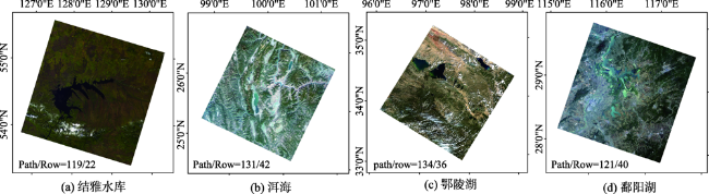
表3 各个实验区影像数据基本信息表Tab. 3 Basic information table of image data in each experimental area |
| 实验区 | 条带号(path/row) | 数据类型 | 日期 | 影响因素 |
|---|---|---|---|---|
| 结雅水库 | 119/022 | Landsat8 | 2019-11-25 | 冰雪 |
| 洱海 | 131/042 | Landsat8 | 2019-11-29 | 云 |
| 鄂陵湖 | 134/036 | Landsat8 | 2019-07-29 | 山体阴影 |
| 鄱阳湖 | 121/040 | Landsat8 | 2020-04-01 | 建筑物 |
表4 不同方法的提取结果精度评估表Tab. 4 Accuracy evaluation table of extraction results of different methods |
| Kappa系数 | 总体精度/% | ||||||||
|---|---|---|---|---|---|---|---|---|---|
| NDWI | MNDWI | SMDPSO | MEDPSO | NDWI | MNDWI | SMDPSO | MEDPSO | ||
| 结雅水库 | 0.86 | 0.81 | 0.85 | 0.91 | 93.2 | 90.8 | 92.6 | 99.0 | |
| 洱海 | 0.78 | 0.78 | 0.81 | 0.90 | 92.1 | 88.3 | 86.9 | 97.8 | |
| 鄂陵湖 | 0.84 | 0.88 | 0.71 | 0.91 | 93.0 | 94.8 | 87.7 | 98.1 | |
| 鄱阳湖 | 0.72 | 0.89 | 0.76 | 0.90 | 89.0 | 95.6 | 86.4 | 98.0 | |
| [1] |
张毅, 陈成忠, 吴桂平, 等. 遥感影像空间分辨率变化对湖泊水体提取精度的影响[J]. 湖泊科学, 2015,27(2):335-342.
[
|
| [2] |
张莹莹, 蔡晓斌, 杨超, 等. 1974-2017年洪湖湿地自然保护区景观格局演变及驱动力分析[J]. 湖泊科学, 2019,31(1):171-182.
[
|
| [3] |
陈亚宁, 杨青, 罗毅, 等. 西北干旱区水资源问题研究思考[J]. 干旱区地理, 2012,35(1):1-9.
[
|
| [4] |
张奇, 刘元波, 姚静, 等. 我国湖泊水文学研究进展与展望[J]. 湖泊科学, 2020,32(5):1360-1379.
[
|
| [5] |
|
| [6] |
周成虎, 骆剑承, 杨晓梅, 等. 遥感影像地学理解与分析[M]. 北京: 科学出版社, 1999: 68-90.
[
|
| [7] |
李晶, 李恩来, 苗慧玲, 等. 基于LandsatTM数据的济宁市水体识别方法研究[J]. 环境科学与技术, 2013,36(9):175-179,186.
[
|
| [8] |
|
| [9] |
徐涵秋. 利用改进的归一化差异水体指数( MNDWI) 提取水体信息的研究[J]. 遥感学报, 2005,9(5):589-595.
[
|
| [10] |
王占昌. 利用决策树对卫星遥感数据进行分类[J]. 青海科技, 2005(5):28-33.
[
|
| [11] |
曹凯, 江南, 吕恒, 等. 面向对象的 SPOT 5影像城区水体信息提取研究[J]. 国土资源遥感, 2007,19(2):27-30.
[
|
| [12] |
陈前, 郑利娟, 李小娟, 等. 基于深度学习的高分遥感影像水体提取模型研究[J]. 地理与地理信息科学, 2019,35(4):43-49.
[
|
| [13] |
王栋, 李开渊, 王鹏. 城市水体信息提取方法对比分析研究[J]. 经纬天地, 2016(2):34-39.
[
|
| [14] |
|
| [15] |
|
| [16] |
许卫东, 尹球, 匡定波. 地物光谱匹配模型比较研究[J]. 红外与毫米波学报, 2005(4):296-300.
[
|
| [17] |
|
| [18] |
王玉, 张万昌, 李旺平, 等. 耦合最大熵模型的离散粒子群水体提取[J]. 河南科学, 2020,38(4):538-545.
[
|
| [19] |
徐涵秋. 从增强型水体指数分析遥感水体指数的创建[J]. 地球信息科学, 2008,10(6):6776-6780.
[
|
| [20] |
丁凤. 一种基于遥感数据快速提取水体信息的新方法. 遥感技术与应用, 2009,24(2):167-171.
[
|
| [21] |
|
| [22] |
蔡伟, 杨少愚, 杨娜. 基于改进粒子群算法在GIS最优路径中的研究[J]. 测绘与空间地理信息, 2018,41(6):116-118.
[
|
| [23] |
|
| [24] |
|
| [25] |
王彩艳, 王瑷玲, 王介勇, 等. 基于面向对象的海岸带土地利用信息提取研究[J]. 自然资源学报, 2014,29(9):1589-1597.
[
|
| [26] |
张华杰, 李庆军. 中甸灯台报春与鹅黄灯台报春的系统演化[J]. 广西植物, 2017,37(2):153-161,259.
[
|
| [27] |
|
| [28] |
|
| [29] |
何红术, 黄晓霞, 李红旮, 等. 基于改进U-Net网络的高分遥感影像水体提取[J]. 地球信息科学学报, 2020,22(10):2010-2022.
[
|
| [30] |
李宜雪, 董增川, 肖敬, 等. 结雅、布列亚水库对黑龙江防洪需求的响应[J]. 人民黄河, 2019,41(3):53-59.
[
|
| [31] |
张廷军, 钟歆玥. 欧亚大陆积雪分布及其类型划分[J]. 冰川冻土, 2014,36(3):481-490.
[
|
| [32] |
张红叶, 蔡庆华, 唐涛, 等. 洱海流域湖泊生态系统健康综合评价与比较[J]. 中国环境科学, 2012,32(4):715-720.
[
|
| [33] |
黄慧君, 王永平, 李庆红. 气候变暖背景下洱海水面蒸发量的变化及影响因素[J]. 气象与环境学报, 2010,26(1):32-35.
[
|
| [34] |
苟照君, 刘峰贵. 鄂陵湖[J]. 全球变化数据学报(中英文), 2019,3(1):91-92,200-201.
[
|
| [35] |
吉红霞, 范兴旺, 吴桂平, 等. 离散型湖泊水体提取方法精度对比分析[J]. 湖泊科学, 2015,27(2):327-334.
[
|
| [36] |
王大钊, 王思梦, 黄昌. Sentinel-2和Landsat8影像的四种常用水体指数地表水体提取对比[J]. 国土资源遥感, 2019,31(3):157-165.
[
|
| [37] |
冯珊珊, 樊风雷. Landsat/OLI与夜间灯光数据在提取城市不透水面中的精度差异分析[J]. 地球信息科学学报, 2019,21(10):1608-1618.
[
|
| [38] |
李健锋, 叶虎平, 张宗科, 等. 基于Landsat影像的斯里兰卡内陆湖库水体时空变化分析[J]. 地球信息科学学报, 2019,21(5):781-788.
[
|
| [39] |
李丹, 吴保生, 陈博伟, 等. 基于卫星遥感的水体信息提取研究进展与展望[J]. 清华大学学报(自然科学版), 2020,60(2):147-161.
[
|
| [40] |
龚文峰, 周莹, 李恒, 等. 基于RS和GIS的磨盘山水库面积提取方法研究[J]. 水利科学与寒区工程, 2018,1(12):37-41.
[
|
| [41] |
肖茜, 杨昆, 洪亮. 基于多源数据的云贵高原湖泊水体提取方法对比研究[J]. 云南师范大学学报(自然科学版), 2018,38(2):73-78.
[
|
| [42] |
徐蓉, 张增祥, 赵春哲. 湖泊水体遥感提取方法比较研究[J]. 遥感信息, 2015,30(1):111-118.
[
|
| [43] |
|
| [44] |
张文, 崔长露, 李林宜, 等. 基于长时间序列遥感数据的鄱阳湖水面面积监测分析[J]. 水文, 2019,39(3):29-35,21.
[
|
| [45] |
郭文忠, 陈晓华, 刘耿耿, 等. 基于混合离散粒子群优化的轨道分配算法[J]. 模式识别与人工智能, 2019,32(8):758-770.
[
|
| [46] |
赵娟娟, 谈树成, 杨林. 不同辐射校正水平下植被指数特征对比分析[J]. 云南地理环境研究, 2017,29(6):1-8,79.
[
|
| [47] |
杨磊, 潘志强, 傅俏燕, 等. 资源三号卫星多光谱数据的大气校正研究[J]. 光谱学与光谱分析, 2013,33(7):1903-1907.
[
|
/
| 〈 |
|
〉 |