
基于DEM的黄土高原地形纹理概念模型
|
蒋 圣(1984— ),男,江苏宜兴人,博士,高级工程师,主要从事模式识别和数字地形分析研究。E-mail: 214230267@qq.com |
收稿日期: 2020-07-29
要求修回日期: 2021-09-15
网络出版日期: 2021-08-25
基金资助
国家自然科学基金项目(41930102)
国家自然科学基金项目(41971333)
国家自然科学基金项目(41771415)
国家自然科学基金项目(41401440)
江苏高校优势学科建设工程资助项目
版权
Conceptual Model of Terrain Texture in Loess Plateau based on DEM
Received date: 2020-07-29
Request revised date: 2021-09-15
Online published: 2021-08-25
Supported by
National Natural Science Foundation of China(41930102)
National Natural Science Foundation of China(41971333)
National Natural Science Foundation of China(41771415)
National Natural Science Foundation of China(41401440)
Priority Academic Program Development of Jiangsu Higher Education Institutions
Copyright
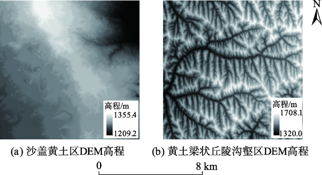
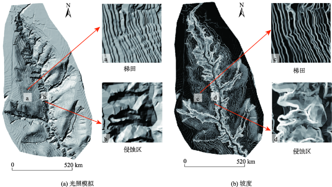
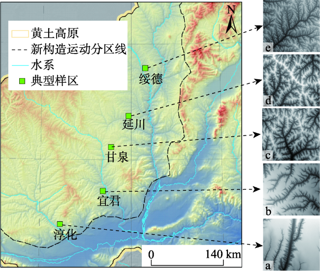
黄土高原“千沟万壑”的地貌形态,在多尺度空间下表现出显著自相似性,具有“局部无规则,宏观有规律”的纹理特征。目前,黄土高原地形纹理的提取方法及应用已经得到初步发展,但依然缺乏在理论层面的框架体系。本文在已有学者研究成果的基础上,限定黄土高原为研究范围,明确提出黄土高原地形纹理的概念模型,即内涵、特征、分类及表达。将内涵进行扩展,除已有的宏观形态地形纹理外,提出黄土典型地貌单元(黄土塬、梁、峁等)特征组合形成的地形纹理,以及黄土坡面坡度特征形成的地形纹理;指出以数字高程模型为主的数据表达将更有利于地形纹理的量化,特别是基于DEM派生的坡面地形因子能够扩展地形纹理的特征空间,丰富地形纹理分析的数据源;明确地形纹理的基本特征,分别是区域差异性、成因复杂性和尺度依赖性;构建划分体系,以地形纹理的基元显著性、纹理成因以及可视化形态进行类别划分。本文以期构建面向黄土高原的地形纹理概念模型,推动纹理分析方法在黄土高原的应用和发展。
蒋圣 , 汤国安 , 杨昕 , 熊礼阳 , 钱程扬 . 基于DEM的黄土高原地形纹理概念模型[J]. 地球信息科学学报, 2021 , 23(6) : 959 -968 . DOI: 10.12082/dqxxkx.2021.200411
The geomorphic characteristics of "thousands of gullies" in the Loess Plateau show significant self similarity in multi-scale space, and have obvious textural characteristics of local-irregular and macro-regular. Previous studies have shown that there have been specific research results on the selection of texture features, the uncertainty of scale effect, and the combination of texture features with other features in identification and classification of specific landforms. However, the current texture analysis methods are limited to the application of macro terrain classification. For the concept, classification, basic characteristics, and analysis methods of terrain texture, there is a lack of theoretical framework for application support. On the basis of the existing research results, this paper defines the Loess Plateau as the research scope, and puts forward the concept model of the Loess Plateau terrain texture, namely definition, characteristics, classification, and expression. In terms of the definition of terrain texture, this paper expands the scope of the definition. In addition to the existing macro morphological topographic texture, the terrain texture formed by the combination of the characteristics of typical loess geomorphic units (loess yuan, liang, mao, etc.) and the terrain texture formed by the slope characteristics of loess slope are proposed. This paper points out that the data expression based on Digital Elevation Model (DEM) will be more conducive to the quantification of terrain texture, especially the terrain factor derived from DEM can expand the feature space of terrain texture and enrich the data source of terrain texture analysis. In terms of the basic features of terrain texture, this paper puts forward three basic characteristics: regional difference, genetic complexity, and scale dependence. Among them, regional differences can be qualitatively distinguished by visualization or quantified by existing statistical methods, so as to effectively distinguish differences in texture between regions. In the classification system of terrain texture, this paper classifies the terrain texture based on its element saliency, texture origin, and visual form. Taking loess liang in the loess hilly and gully region as an example, a single loess liang can be regarded as a texture element. Through a certain arrangement and combination of several loess liang, the terrain textural characteristics of the loess liang hilly and gully region are formed. However, a single loess liang cannot express the texture features. This paper aims to build a conceptual model of terrain texture oriented to the Loess Plateau, and promotes the application and development of texture analysis method in Loess Plateau.
| [1] |
刘东生. 中国的黄土堆积[M]. 北京: 科学出版社, 1965.
[
|
| [2] |
鹿化煜, 安芷生. 前处理方法对黄土沉积物粒度测量影响的实验研究. 科学通报, 1997,42(23):2535-2538.
[
|
| [3] |
|
| [4] |
汪海斌, 于英鹏, 刘现彬, 等. 黄土高原S1古土壤的地球化学特征及其对物源的指示[J]. 第四纪研究, 2011,31(2):338-346.
[
|
| [5] |
|
| [6] |
|
| [7] |
夏积德, 吴发启, 周波. 黄土高原丘陵沟壑区坡地耕作方式对土壤侵蚀的影响研究[J]. 水土保持学报, 2016,30(4):64-67.
[
|
| [8] |
汤国安, 那嘉明, 程维明. 我国区域地貌数字地形分析研究进展[J]. 测绘学报, 2017,46(10):1570-1591.
[
|
| [9] |
|
| [10] |
陶旸. 基于纹理分析方法的DEM地形特征研究[D]. 南京:南京师范大学, 2011.
[
|
| [11] |
汤国安, 李发源, 熊礼阳. 黄土高原数字地形分析研究进展[J]. 地理与地理信息科学, 2017,33(4):1-7.
[
|
| [12] |
刘凯, 汤国安, 黄骁力, 等. 面向地形特征的DEM与影像纹理差异分析[J]. 地球信息科学学报, 2016,18(3):386-395.
[
|
| [13] |
黄骁力, 汤国安, 刘凯. DEM分辨率对地形纹理特征提取的影响[J]. 地球信息科学学报, 2015,17(7):822-829.
[
|
| [14] |
李可, 晏实江. 基于RILBP的地形结构尺度稳定特征分析[J]. 地理与地理信息科学, 2017,33(4):63-68.
[
|
| [15] |
|
| [16] |
|
| [17] |
李勋, 杨环, 殷宗敏, 等. 基于DEM和遥感影像的区域黄土滑坡体识别方法研究[J]. 地理与地理信息科学, 2017,33(4):86-92.
[
|
| [18] |
陶旸, 王春, 蒋圣. 一种基于改进双树复小波变换的地形纹理特征提取方法[J]. 地理与地理信息科学, 2017,33(4):47-50.
[
|
| [19] |
刘丽, 谢毓湘, 魏迎梅, 等. 局部二进制模式方法综述[J]. 中国图象图形学报, 2014,19(12):1696-1720.
[
|
| [20] |
|
| [21] |
|
| [22] |
|
| [23] |
|
| [24] |
|
| [25] |
王润生. 图像理解[M]. 长沙: 国防科技大学出版社, 1995.
[
|
| [26] |
|
| [27] |
李旭涛, 彭复员, 曹汉强, 等. 地形表面的自相似程度与分类感知[J]. 电子与信息学报, 2007,29(6):1480-1482.
[
|
| [28] |
|
| [29] |
周成虎, 程维明, 钱金凯, 等. 中国陆地1:100万数字地貌分类体系研究[J]. 地球信息科学学报, 2009,11(6):707-724.
[
|
| [30] |
程维明, 周成虎. 多尺度数字地貌等级分类方法[J]. 地理科学进展, 2014,33(1):23-33.
[
|
| [31] |
晏实江, 汤国安, 李发源, 等. 利用DEM边缘检测进行黄土地貌沟沿线自动提取[J]. 武汉大学学报:信息科学版, 2011,36(3):363-367.
[
|
| [32] |
杨昕. 基于DEM地形指数的尺度效应与尺度转换[D]. 南京:南京师范大学, 2007.
[
|
| [33] |
马红斌, 李晶晶, 何兴照, 等. 黄土高原水平梯田现状及减沙作用分析[J]. 人民黄河, 2015,37(2):89-93.
[
|
| [34] |
于浩, 刘志红, 张晓萍, 等. 基于傅立叶变换的梯田纹理特征提取[J]. 国土资源遥感, 2008,20(2):39-42.
[
|
| [35] |
刘凯. 基于多源数据的黄土高原(重点流失区)侵蚀沟提取及区域差异性研究[D]. 南京:南京师范大学, 2017.
[
|
/
| 〈 |
|
〉 |