
基于轨迹偏移算法的居民就医时空特征与空间格局分析
|
丁 威(1995— ),男,河南郑州人,硕士生,主要从事地理空间数据挖掘研究。E-mail: 641536291@qq.com |
收稿日期: 2020-09-03
要求修回日期: 2020-12-24
网络出版日期: 2021-08-25
基金资助
国家自然科学基金项目(41471333)
中央引导地方科技发展专项项目(2017L3012)
版权
Analysis of Spatiotemporal Characteristics and Spatial Patterns of Residents' Medical Treatment based on Algorithm of Trajectory Drift
Received date: 2020-09-03
Request revised date: 2020-12-24
Online published: 2021-08-25
Supported by
National Natural Science Foundation of China(41471333)
The Central Guided Local Development of Science and Technology Project(2017L3012)
Copyright
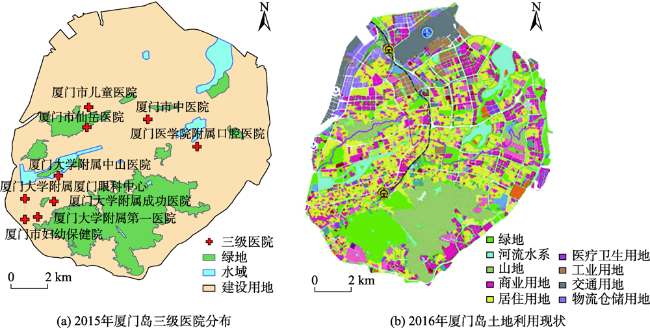
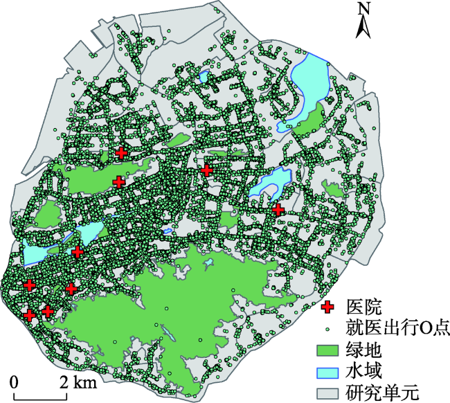
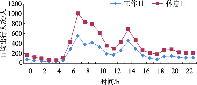
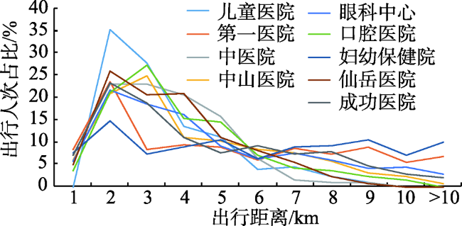
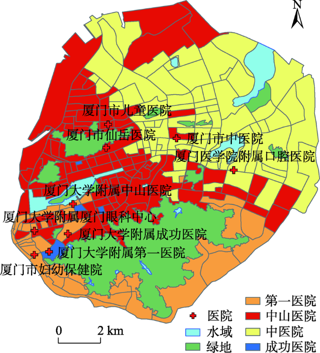
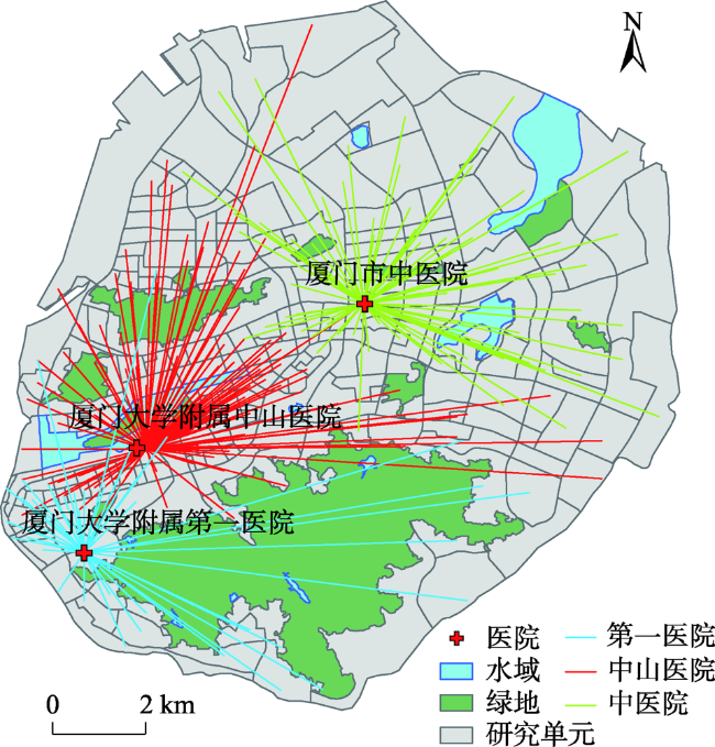
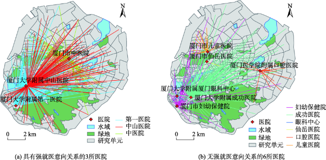
居民就医时空特征与空间格局反映了医疗设施的服务能力与布局合理性。本文以厦门岛为例,采用出租车轨迹数据,探讨了居民就医的时空特征和空间格局。论文提出了基于道路中心线的研究单元划分方法;提出OD轨迹偏移算法,更精细地提取出三级医院的就医OD数据,改善传统的缓冲区分析法中精确度较低的问题;对居民就医行为进行时空特征分析;基于就医意向与K-means聚类算法分析了居民的就医空间格局。结果表明:① 相对于传统的缓冲区分析,使用OD轨迹偏移算法提取医院的就医OD数据时,不要求OD数据具有较高的定位精度,仅通过偏移OD点坐标即可更加准确与完整地提取就医OD数据,精度提高约30%以上,并适用于所有浮动车轨迹数据;② 居民就医高峰期在7时与14时,休息日日均就医人次为工作日的2倍,当就医出行距离大于1 km时,就医出行人次随着出行距离的增加不断减少,整体符合韦伯分布函数;③ 居民就医时首要选择中山医院、第一医院或中医院,就医选择具有显著的区域性差异,反映居民临近就医的习惯,厦门岛西南部区域医疗资源十分充足,居民首要选择的就医最大出行距离在4 km以内,而西北部与东南部区域的居民首要选择的就医出行距离多在10 km左右,医疗资源较为匮乏,亟待加强;④ 厦门岛三级医院的吸引力具有明显的层次性,居民的强就医意向 (Pij>33%)的医院皆为中山医院、第一医院与中医院中的1所,这3所医院的服务范围基本包括整个厦门岛,对居民有着较强的吸引力,居民对其余6所医院的就医意向值在0~33%之间,服务范围基本为医院临近的一些区域,吸引力与服务能力相对较弱。研究结果不仅为挖掘居民就医时空特征提供方法参考,还为后续医疗设施资源空间配置优化提供决策支持。
丁威 , 邬群勇 . 基于轨迹偏移算法的居民就医时空特征与空间格局分析[J]. 地球信息科学学报, 2021 , 23(6) : 979 -991 . DOI: 10.12082/dqxxkx.2021.200506
The spatial and temporal characteristics of residents' medical treatment reflect the service capacity and layout rationality of medical facilities. This study investigated the features and patterns of medical treatment using taxi trajectory data in Xiamen. We divided Xiamen Island into different research units based upon the central lines of roads. We presented a trajectory drift algorithm to extract the medical treatment OD data for tertiary hospitals. This algorithm deals with the positional error associated with trajectory data and can improve the extraction accuracy. Hospitalizing behavior was analyzed from the perspective of space and time. Finally, based on the residents' preference for hospitals, we discussed the spatial patterns of residents' medical treatment by K-means algorithm. The results show that: (1) Compared with traditional buffer analysis, the trajectory drift algorithm didn't require high positioning accuracy when extracting OD data for hospitals. OD data can be extracted more reasonably and completely only by shifting OD point's coordinates, with an accuracy increased by more than 30%. It was also applicable to all floating vehicle trajectory data; (2) The peak time of medical treatment occurred at 7 am and 2 pm, respectively. The number of medical visits was twice on weekends (including holidays) than working days. When the travel distance was greater than 1 km, the number of medical visits decreased with the increase of travel distance, following a Weibull function distribution; (3) Residents regarded the Zhongshan, the First Affiliated, and the Chinese Medicine Hospital as their first choice for medical treatment. There was a significant regional difference in choices of medical treatment, that is residents preferred nearby hospitals. The southwest of Xiamen Island had sufficient medical resources, and residents' average medical travel distance was less than 4 km. However, residents in northwest and southeast of Xiamen Island mostly had to travel about 10 km for medical treatment. The medical resources in these regions were relatively scarce and needed to be strengthened eagerly; (4) The service capacity of the nine tertiary hospitals in Xiamen Island was obviously different. The residents had a strong preference for the Zhongshan, the First Affiliated, and the Chinese Medicine hospitals, with evaluated preference values greater than 33%. The service scopes of these three hospitals basically covered the whole Xiamen Island, which indicated strong attraction and service capacity for the residents. The values of residents' preference for the other six hospitals ranged from 0 to 33%. These six hospitals mainly treated nearby residents, leading to weak attraction and service capacity. This study provides alternative methods to extract the spatiotemporal features of residents' medical treatment and supports the decision-making of optimizing the spatial configuration of medical facilities.
表1 轨迹数据样例 (2015年6月13日)Tab. 1 Sample of trajectory data (13 June 2015) |
| 车辆ID | 日期时间 | 经度/°E | 纬度/°N | 车速/(km/h) | 空重车状态 |
|---|---|---|---|---|---|
| 1000 | 00:00:55 | 118.120 | 24.515 | 14.8 | 空 |
| 1000 | 00:01:55 | 118.119 | 24.512 | 38.9 | 重 |
| 1000 | 00:02:55 | 118.115 | 24.513 | 44.4 | 重 |
| 1000 | 00:03:55 | 118.115 | 24.511 | 38.9 | 重 |
| 1000 | 00:04:55 | 118.110 | 24.510 | 25.9 | 重 |
| 1000 | 00:05:55 | 118.104 | 24.508 | 50.2 | 重 |
| 1000 | 00:06:55 | 118.101 | 24.503 | 48.2 | 重 |
| 1000 | 00:07:55 | 118.101 | 24.503 | 48.2 | 重 |
| 1000 | 00:08:55 | 118.095 | 24.493 | 1.9 | 空 |
| 1000 | 00:09:55 | 118.090 | 24.492 | 51.9 | 空 |
| [1] |
丁愫, 陈报章. 城市医疗设施空间分布合理性评估[J]. 地球信息科学学报, 2017,19(2):185-196.
[
|
| [2] |
|
| [3] |
刘静, 朱青. 城市公共服务设施布局的均衡性探究——以北京市城六区医疗设施为例[J]. 城市发展研究, 2016,23(5):6-11.
[
|
| [4] |
高文秀, 范香, 郑芬, 等. 综合公园及其有效服务范围的空间布局分析[J]. 城市规划, 2017,41(11):97-101,110.
[
|
| [5] |
刘晓慧, 刘永伟, 蔡菲, 等. 面向时空可达性的城市应急医疗机构推荐方法[J]. 地球信息科学学报, 2019,21(9):1411-1419.
[
|
| [6] |
|
| [7] |
|
| [8] |
|
| [9] |
谢小华, 王瑞璋, 文东宏, 等. 医疗设施布局的GIS优化评价——以翔安区医疗设施为例[J]. 地球信息科学学报, 2015,17(3):317-328.
[
|
| [10] |
|
| [11] |
侯松岩, 姜洪涛. 基于城市公共交通的长春市医院可达性分析[J]. 地理研究, 2014,33(5):915-925.
[
|
| [12] |
陈锐, 董晓健, 鲍臻, 等. 大型医院专科医疗服务半径的探讨[J]. 现代生物医学进展, 2011,11(4):788-790.
[
|
| [13] |
程曦, 方鹏骞, 陈晶, 等. 基于患者体验的珠海市公立医院卫生服务利用分析[J]. 中国医院, 2020,24(2):37-39.
[
|
| [14] |
李青芫. 面向老年人的广州市三级医院可达性研究[D]. 广州大学, 2017.
[
|
| [15] |
陈意. 分级诊疗模式下患者就医行为与机构选择研究[D]. 合肥:合肥工业大学, 2019.
[
|
| [16] |
邬群勇, 张良盼, 吴祖飞. 顾及空间异质性的出租载客与公交客流回归分析[J]. 地球信息科学学报, 2019,21(3):337-345.
[
|
| [17] |
陈锐, 陈明剑, 姚翔, 等. 利用导航大数据挖掘城市热点区域关联性[J]. 地球信息科学学报, 2019,21(6):826-835.
[
|
| [18] |
郑晓琳, 刘启亮, 刘文凯, 等. 智能卡和出租车轨迹数据中蕴含城市人群活动模式的差异性分析[J]. 地球信息科学学报, 2020,22(6):1268-1281.
[
|
| [19] |
潘晓芳. 基于浮动车轨迹数据的可达性研究[D]. 武汉:中国地质大学(武汉), 2018.
[
|
| [20] |
齐兰兰, 周素红, 闫小培. 广州市医疗设施可达性模型中端点吸引的影响因素检验[J]. 地理科学, 2014,34(5):580-586.
[
|
| [21] |
陈卓然, 黄翀, 刘高焕, 等. 基于出租车GPS数据的居民就医时空特征分析[J]. 地球信息科学学报, 2018,20(8):1111-1122.
[
|
| [22] |
李华, 潘晓芳, 杨林, 等. 出租车GPS轨迹下的医疗设施服务半径确定[J]. 测绘通报, 2018(8):78-83.
[
|
| [23] |
资源环境科学与数据中心. 厦门POI数据[DB/OL]. http://www.resdc.cn/data.aspx?DATAID=338, 2019-09-01.
[ Resource and Environment Science and Data Center. POI Data of Xiamen[DB/OL]. http://www.resdc.cn/data.aspx?DATAID=338, 2019-09-01.]
|
| [24] |
厦门市自然资源和规划局. 厦门市城市总体规划(2011—2020)用地规划图[DB/OL]. http://zygh.xm.gov.cn/zwgk/zdxxgk/ghcg/ztgh/201909/W020201130350651011303.jpg, 2019-09-06.
[ Xiamen Municipal Natural Resources and Planning Bureau. Master Plan Land Planning Map in Ximen (2011-2020)[DB/OL]. http://zygh.xm.gov.cn/zwgk/zdxxgk/ghcg/ztgh/2019.09/W020201130350651011303.jpg, 2019-09-06.]
|
| [25] |
资源环境科学与数据中心. 厦门建筑轮廓数据[DB/OL]. http://www.resdc.cn/data.aspx?DATAID=270, 2019-09-01.
[ Resource and Environment Science and Data Center. Building Outline Data of Xiamen[DB/OL]. http://www.resdc.cn/data.aspx?DATAID=270, 2019-09-01.]
|
| [26] |
Open Street Map. Vector data of Xiamen[DB/OL]. http://download.geofabrik.de/asia/china.html, 2019-09-23.
|
| [27] |
厦门卫星定位发展股份有限公司 出租车GPS定位数据[DB/OL]. https://www.xmgps.com/content/index/278, 2019-08-30.
[ Xiamen GNSS Development & application Company Limited. GPS Positioning Data of Taxi[DB/OL]. https://www.xmgps.com/content/index/278, 2019-08-30.]
|
| [28] |
|
| [29] |
|
| [30] |
|
| [31] |
|
| [32] |
王亮, 胡琨元, 库涛, 等. 基于多尺度空间划分与路网建模的城市移动轨迹模式挖掘[J]. 自动化学报, 2015,41(1):47-58.
[
|
| [33] |
陈哲, 刘竟芳, 陈伟, 等. 长沙市社区老年人慢性病患病情况、就医意向及影响因素分析[J]. 实用预防医学, 2020,27(3):270-273.
[
|
/
| 〈 |
|
〉 |

