
基于格网化邻域查询的海上船舶救援搜索方法
|
周为峰(1978— ),女,江苏高邮人,副研究员,从事空间信息技术在渔业上的应用研究。E-mail: zhwfzhwf@163.com |
收稿日期: 2020-11-16
要求修回日期: 2021-03-12
网络出版日期: 2021-10-25
基金资助
国家重点研发计划项目(2019YFD0901405)
国家重点研发计划项目(2020YFD0901202)
中央级公益性科研院所基本科研业务费专项(东海水产研究所)(2019T03)
版权
Searching Method for Marine Ship Rescue based on Grid Neighborhood Query
Received date: 2020-11-16
Request revised date: 2021-03-12
Online published: 2021-10-25
Supported by
National Key R&D Program of China(2019YFD0901405)
National Key R&D Program of China(2020YFD0901202)
Special Research Fund for The National Non-profit Institutes(ECSFRI/CAFS)(2019T03)
Copyright
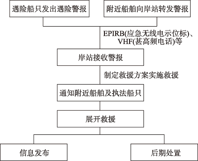
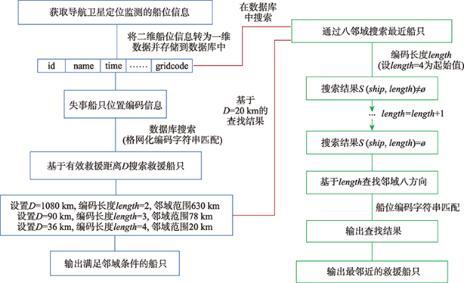
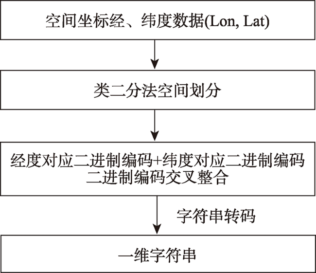
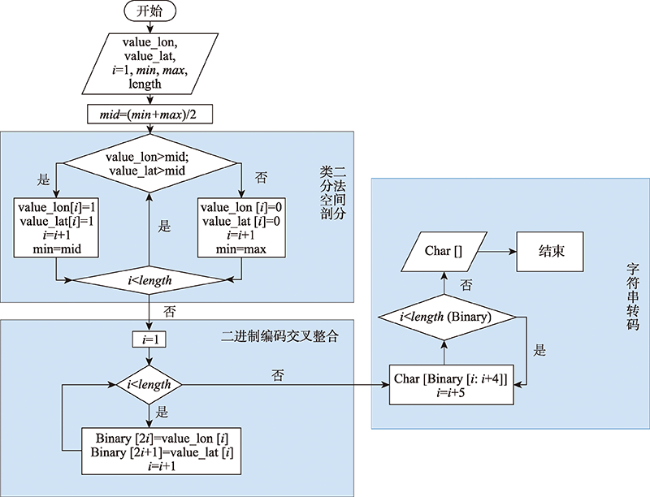
海洋渔业是高风险行业,各类海洋灾害频繁发生,海上航行、作业环境复杂,因此,海上快速救援对保护渔民的生命财产安全具有重要意义。本文基于空间剖分的格网化编码,提出一种根据有效救援距离和失事船舶位置进行邻域搜索以查找失事船只相邻和最邻近可供救援的船只的方法,其中有效救援距离通过救援船舶的类型和航速来设定,根据有效救援距离设置不同的编码搜索长度。本文将模拟实验区域设定为我国东海海域,随机生成1×10⁴个船位点,在时间检索效率和内存占用两方面,实验结果表明,与传统的船舶间距离的计算方法相比,基于格网化邻域搜索的查询方法编码后船位数据较编码转换前船位数据占用内存空间减少56.47%,同时,编码后检索运算的用户时间是编码前用户时间的17.67%,因此,基于格网化邻域搜索的查询方法占用内存小,且运算效率较高,能够有效提升对遇险船舶邻域救援船只的查询效率。
周为峰 , 隋芯 , 郭小天 , 姜亚洲 , 程田天 . 基于格网化邻域查询的海上船舶救援搜索方法[J]. 地球信息科学学报, 2021 , 23(8) : 1422 -1432 . DOI: 10.12082/dqxxkx.2021.200690
Marine fishery is a high-risk industry with various marine disasters occurring frequently. Furthermore, maritime navigation and operating environment are complicated. Therefore, rapid maritime rescue is of great significance to protect the life and property of fishermen. Based on the grid coding of spatial division, this paper proposes a method to search the neighborhood based on the effective rescue distance and the location of the wrecked ship to find the ships that are adjacent to the wrecked ship and the closest neighbor for rescue. The effective rescue distance is set by the type and speed of the rescue ship. Then, the different code search lengths are set according to the effective rescue distances. In this paper, East Sea is set as the simulation experiment area, within which 10 000 ship locations are randomly generated. In terms of time retrieval efficiency and memory occupation, the experimental results show that, compared with the traditional method of calculating the distances among ships, the memory space occupation by the ship position data after encoding conversion in our proposed method is 56.47% less than that before the encoding conversion. In the meantime, the user retrieval calculation time after encoding is only 17.67% of that before the encoding. Therefore, after the ship position is encoded, the proposed method occupies a smaller memory and has a higher computational efficiency, which can greatly improve the efficiency searching for rescue ships in the vicinity of the wrecked ship.
表1 邻域船位查询的数据库表结构Tab. 1 Table structure of the database for neighborhood ship position query |
| 表名 | gridcode_vessels | ||
|---|---|---|---|
| 列名 | 数据类型(精度范围) | 空/非空 | 中文名称 |
| name | varchar(50) | 非空 | 船名 |
| id | int | 非空 | 船舶编号 |
| time | datetime | 非空 | 船位数据发出时间 |
| longitude | float | 非空 | 船舶经度 |
| latitude | float | 非空 | 船舶纬度 |
| speed | float | 非空 | 航速 |
| direction | char | 空 | 航向 |
| gridcode | varchar(50) | 非空 | 船位格网化编码 |
表2 不同类型船舶的有效救援距离计算Tab. 2 Effective distances of different types of rescue vessels (km) |
| 航速(海里/h) | 救援时间/h | |||
|---|---|---|---|---|
| 2 | 5 | 10 | 24 | |
| 8(渔船、运输船) | 28.8 | 72.0 | 144.0 | 345.6 |
| 9(渔船、运输船) | 32.4 | 81.0 | 162.0 | 388.8 |
| 10(渔船、运输船) | 36.0 | 90.0 | 180.0 | 432.0 |
| 25(快艇式救援船) | 90.0 | 225.0 | 450.0 | 1080.0 |
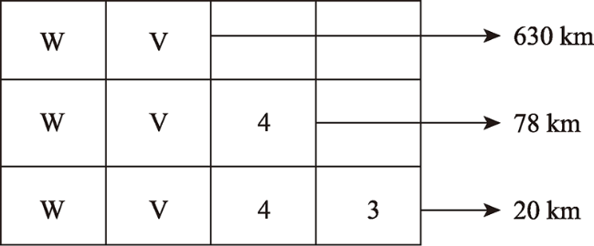
表3 编码长度、剖分次数及精度对应Tab. 3 Correspondence table of code length, division times and accuracy |
| 编码长度 | 剖分次数 | 格网大小/km | 与有效救援距离的对应 |
|---|---|---|---|
| 1 | 1 | 2500 | |
| 2 | 5 | 630 | <D3 |
| 3 | 7.5 | 78 | <D2 |
| 4 | 10 | 20 | <D1 |
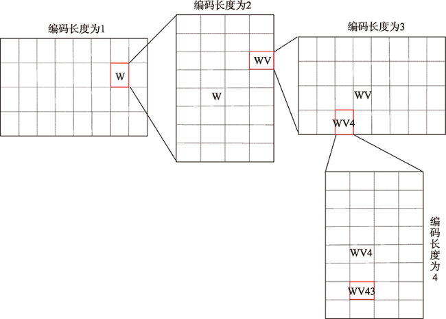
图5 空间位置与编码的嵌套关系Fig. 5 Recursive relationship between spatial position and encoding |
表4 奇数位邻域编码表Tab. 4 Odd-numbered neighborhood coding table |
| … | |||||||||||
|---|---|---|---|---|---|---|---|---|---|---|---|
| 0 | 1 | 4 | 5 | h | j | n | p | ||||
| … | z | b | c | f | g | u | v | y | z | b | … |
| x | 8 | 9 | d | e | s | t | w | x | 8 | ||
| r | 2 | 3 | 6 | 7 | k | m | q | r | 2 | ||
| p | 0 | 1 | 4 | 5 | h | j | n | p | 0 | ||
| b | c | f | g | u | v | y | z | ||||
| … | |||||||||||
表5 偶数位邻域编码表Tab. 5 Even-numbered neighborhood coding table |
| … | |||||||
|---|---|---|---|---|---|---|---|
| 0 | 2 | 8 | b | ||||
| … | z | p | r | x | z | p | … |
| y | n | q | w | y | n | ||
| v | j | m | t | v | j | ||
| u | h | k | s | u | h | ||
| g | 5 | 7 | e | g | 5 | ||
| f | 4 | 6 | d | f | 4 | ||
| c | 1 | 3 | 9 | c | 1 | ||
| b | 0 | 2 | 8 | b | 0 | ||
| p | r | x | z | ||||
| … | |||||||
| 查找S(length)空集算法 |
|---|
| For length<-5 to 8 by 1 /*图2中编码长度变量length循环起始值为5,循环最大值为8即船位编码长度,循环步长为1 */; IF S(length) = ∅ /* 当S(length) 为空集,则跳出循环,输出本次循环length */; THEN return length; ELSE IF S(length) ≠ ∅ and length ≠8 /* 匹配查找后的集合 S(length)为非空且编码长度未至8*/; THEN return( ) /*S(length)为非空,将结束本次条件判断,继续循环 */; ELSE return S(length) /* 此时,S(length) ≠ ∅,且满足 length=8,则将S(length)作为最终结果输出*/ End IF End /*结束循环*/ |
表6 wv43k邻域编码表Tab. 6 wv43k neighborhood coding table |
| wv43e | wv43s | wv43t |
|---|---|---|
| wv437 | wv43k | wv43m |
| wv435 | wv43h | wv43j |
表7 (127.1257°E, 28.3491°N)船只及邻域索引结果表Tab. 7 (127.1257°E, 28.3491°N) Ship and neighborhood index results table |
| id | gridcode | longitude | latitude |
|---|---|---|---|
| 8843 | wv43t | 127.151 | 28.408 |
表8 编码前后对比结果Tab. 8 Comparison results before and after encoding |
| 程序运行时间/s | 内存占用/Byte | |||
|---|---|---|---|---|
| 用户 | 系统 | 流逝 | ||
| 经纬度搜索 | 1.98 | 0.00 | 1.98 | 240 896 |
| 格网化编码搜索 | 0.35 | 0.04 | 0.52 | 104 856 |
| [1] |
钟碧良. VTSAIS信息环境下船舶救援信息系统初步研究[J]. 广州航海高等专科学校学报, 2011, 19(4):8-10.
[
|
| [2] |
黄锦鹏. 国际海上避碰规则与我国渔船现状的矛盾分析与探讨[J]. 南通航运职业技术学院学报, 2010, 9(1):40-45.
[
|
| [3] |
董加伟. 渔业海难救助困境解析[J]. 大连海事大学学报(社会科学版), 2014, 13(6):57-61.
[
|
| [4] |
杨丽. 近海捕捞船舶海上突发事故多元化主体救助研究[D]. 青岛:中国海洋大学, 2015.
[
|
| [5] |
|
| [6] |
李志亮, 刘虎, 艾万政. 舟山海上搜救现状及对策[J]. 水运管理, 2018, 40(3):28-29,33.
[
|
| [7] |
孙茂金, 吕靖. 基于动态GIS的救援船舶海上航行路线精准预报系统[J]. 舰船科学技术, 2018, 40(16):37-39.
[
|
| [8] |
中国水产科学研究院东海水产研究所. 一种基于轨迹聚类的船舶互助组救援有效性检验方法[P]. 中国专利:ZL2014 10686666.7, 2017-04-26.
[East China Sea Fishery Research Institute, Chinese Academy of Fishery Sciences. Ship mutual-aid team rescue validity testing method based on track cluster[P]. Chinese Patent: ZL2014 10686666.7, 2017-04-26. ]
|
| [9] |
农业部. 渔业船舶水上安全突发事件应急预案[N]. 中国渔业报, 2006-8-7(002).
[Ministry of Agriculture. Emergency plan for fishery vessels water safety emergency[N]. China Fishery Newspaper, 2006-8-7(002). ]
|
| [10] |
杨东霞. 海上突发事故应急船舶优选与调度研究[D]. 秦皇岛:燕山大学, 2013.
[
|
| [11] |
崔迪, 张华. 基于马尔科夫链的溢油事故应急救援船舶调度问题研究[J]. 中国水运, 2013, 13(3):24-25.
[
|
| [12] |
周国平. 海上救助历史沿革与海洋救助船技术发展综述[J]. 船舶设计通讯, 2014(增2):16-20.
[
|
| [13] |
|
| [14] |
|
| [15] |
赵雨琪, 牟乃夏, 祝帅兵, 等. 基于GeoHash算法的周边查询应用研究[J]. 软件导刊, 2016, 15(6):16-18.
[
|
| [16] |
栾方军, 张鹏旭, 曹科研. Geohash编码在出租车巡游路线推荐中的应用[J]. 计算机与数字工程, 2020, 48(12):2836-2842.
[
|
| [17] |
耿虎. 现代通信技术在船舶及其救援中的应用[D]. 舟山:浙江海洋大学, 2017.
[
|
| [18] |
向隆刚, 王德浩, 龚健雅. 大规模轨迹数据的Geohash编码组织及高效范围查询[J]. 武汉大学学报·信息科学版, 2017, 42(1):21-27.
[
|
| [19] |
邢凯, 罗永龙, 宁雪莉, 等. 基于Geohash编码的位置隐私保护算法[J]. 计算机工程与应用, 2019, 55(1):96-102.
[
|
| [20] |
中国水产科学研究院东海水产研究所. 基于位置的海洋渔业信息服务方法[P]. 中国专利:ZL2012 1 0332536.4, 2014-09-24.
[East China Sea Fishery Research Institute, Chinese Academy of Fishery Sciences. Position-based marine fishery information serving method[P]. Chinese Patent: ZL2012 1 0332536.4, 2014-09-24. ]
|
| [21] |
王翔, 杨国东. 基于Geohash 的出租车汽车轨迹的存储与应用研究[J]. 科技资讯, 2015, 35:69-71.
[
|
| [22] |
周为峰, 陈雪忠, 樊伟, 等. 基于位置的信息服务在海洋渔业中的应用与展望[J]. 世界科技研究与发展, 2015, 37(5):611-617.
[
|
| [23] |
中国卫星导航系统管理办公室. BD 420006—2015 北斗/全球卫星导航系统(GNSS)定时单元性能要求及测试方法[S]. 2015.
[China Satellite Navigation Office. BD 420006-2015 Beidou/GNSS timing unit performance requirements and test methods[S]. 2015. ]
|
| [24] |
王诚, 刘卫东, 宋佳兴. 计算机组成和设计[M]. 杭州: 浙江大学出版社出版, 2004.
[
|
| [25] |
|
| [26] |
|
| [27] |
王小宁, 刘撷芯, 黄俊文, 等. R语言实战(第2版)[M]. 北京: 人民邮电出版社, 2016.
[
|
/
| 〈 |
|
〉 |
