
基于自然资源大数据的城市多功能景观识别与国土空间规划分区
|
黄隆杨(1995— ),男,重庆南川人,博士生,主要从事生态保护与国土空间规划研究。E-mail: hly@whu.edu.cn |
收稿日期: 2020-12-02
网络出版日期: 2021-11-25
基金资助
国家自然科学基金项目(41871203)
版权
Multi-functional Landscape Identification and Territorial Space Planning Zoning in Yantai City based on Big Data of Natural Resources
Received date: 2020-12-02
Online published: 2021-11-25
Supported by
National Natural Science Foundation of China(41871203)
Copyright
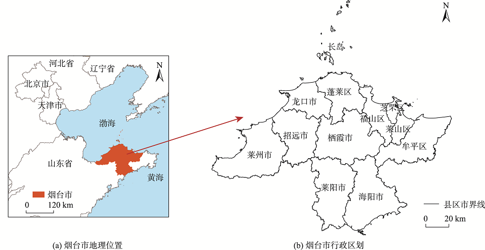
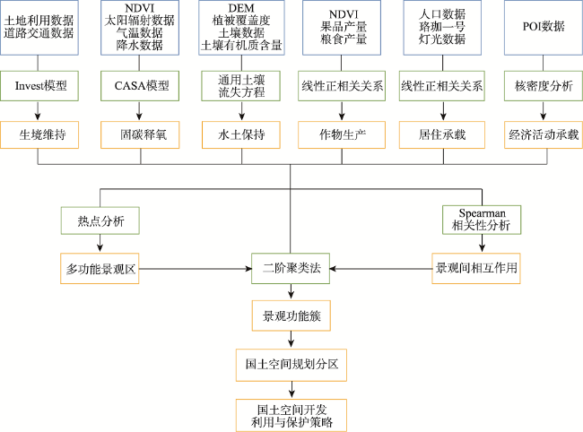
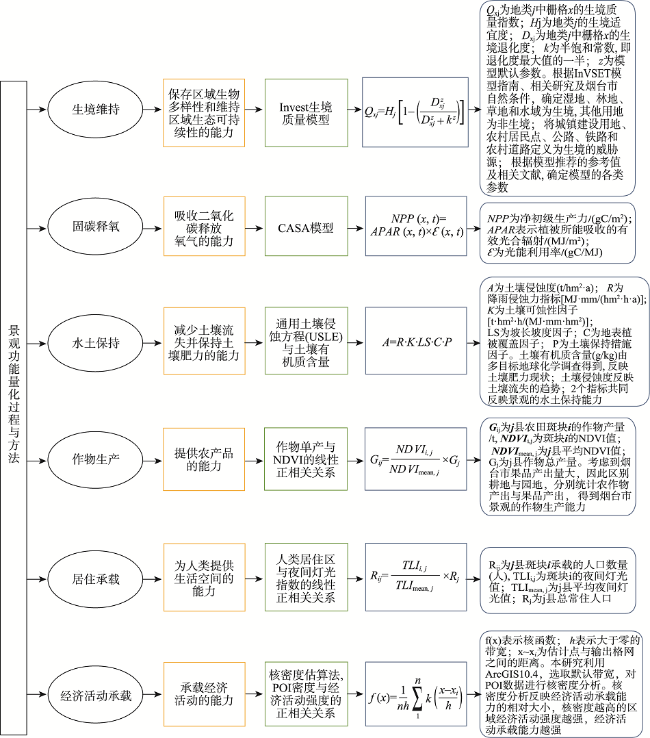
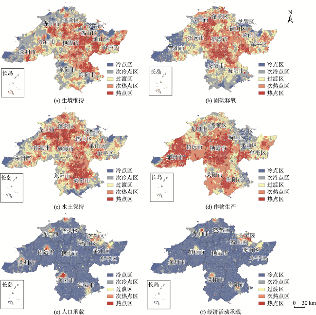
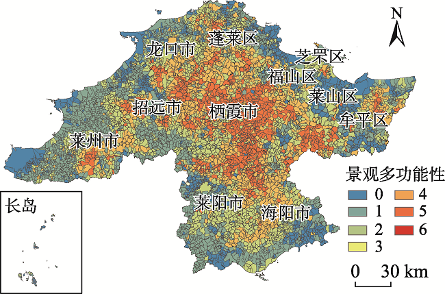
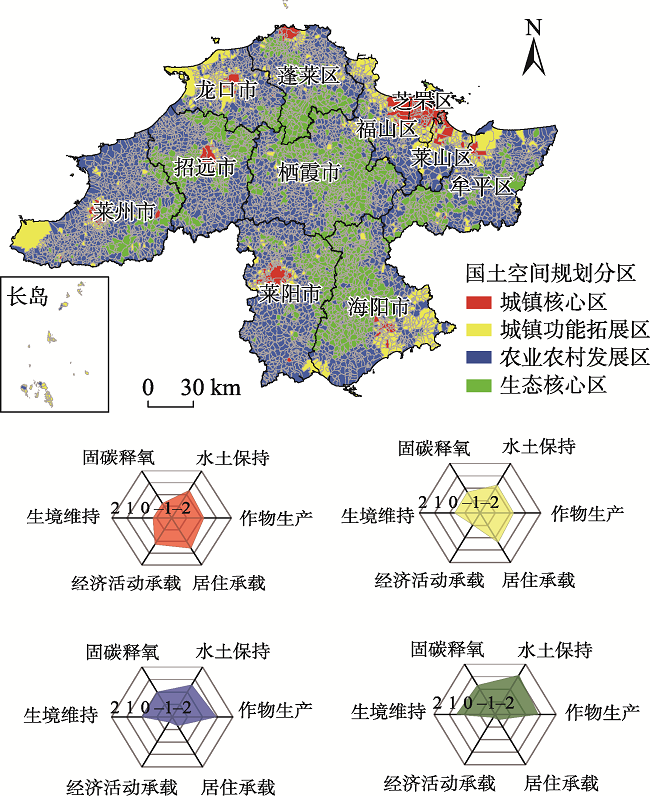
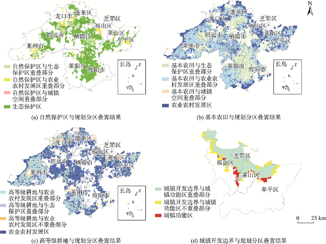
多功能景观能够同时提供多种景观功能,可以充分缓解生态环境压力。在自然资源大数据支撑下基于基层行政管理单元开展的多功能景观研究,可以更加快速准确地反映区域自然地理格局与社会经济发展格局的空间特征与区域差异,其将景观功能管理和行政管理有效结合,能为市县级国土空间规划中控制线的划定和国土空间规划分区提供从功能评估到空间识别等多方面的技术支撑。本文在广泛收集土地利用变更调查数据、自然资源调查评价数据、气象数据、多源遥感数据等自然资源大数据的基础上,结合社会经济数据和兴趣点数据,基于InVEST模型、CASA模型、通用土壤流失方程以及核密度分析等方法对烟台市6种景观功能进行了空间量化;再以村级管理单元为基本空间单元进行景观功能热点分析以识别多功能景观区;利用Spearman相关系数分析各种景观功能间的权衡与协调作用;最后基于二阶聚类法进行景观功能聚类以开展烟台市国土空间规划分区,并制定相应的保护与发展策略。研究表明:① 烟台市35.5%的村级管理单元为多功能景观区;② 自然景观功能间呈协同作用,而自然景观功能与居住和经济承载功能间存在显著的空间冲突和权衡作用;③ 根据景观功能聚类结果,烟台市被划分为生态保护区、农业农村发展区、城镇功能发展区和城镇核心区,面积占比分别为30%,55%,11%,4%。规划分区与现状管理边界在空间上具有较强的一致性和协调性,表明在自然资源大数据支撑下,基于景观功能聚类分析的国土空间规划分区具有相当的准确性和实用性。
黄隆杨 , 王静 , 李泽慧 , 赵晓东 , 刘晶晶 , 方莹 . 基于自然资源大数据的城市多功能景观识别与国土空间规划分区[J]. 地球信息科学学报, 2021 , 23(9) : 1617 -1631 . DOI: 10.12082/dqxxkx.2021.200727
By virtue of providing multiple landscape functions, multi-functional landscape is considered as an important way to relieve the pressure of ecological environment. Supported by the big data of natural resources, the multi-functional landscape research, based on the grass-roots administrative management unit, can more quickly and accurately reflect the spatial characteristics and regional differences of regional physical geography pattern and social-economic development pattern. It can also effectively combine the landscape function management with administrative management, providing technically support for the planning and zoning of territorial space in the aspects of functional assessment and spatial identification. Taking Yantai City as an example, we extensively collected the big data of natural resources, including land use data, natural resource survey and evaluation data, climate data, and multi-source remote sensing data. The natural resource data were used along with the social economy data and Point Of Interest (POI) data to quantify the spatial patterns of Yantai’s six typical landscape functions (Biodiversity maintenance, Carbon sequestration, Soil retention, Crop production, Residential support, Economic activity support) using InVEST model, CASA model, Universal soil loss equations, kernel density analysis, and other methods. The village-level management unit was selected as the basic spatial unit to identify multi-functional landscape areas through the spatial superposition method as well as hot spot analysis. Meanwhile, the trade-offs and coordination between various landscape functions were explored by Spearman's correlation coefficient analysis. Finally, based on the second-order clustering method, the functional clustering of the landscape was conducted and the planning and zoning of territorial space in Yantai City was carried out. The protection and development strategies of various functional zoning were proposed. Results showed that 35.5% of village-level management units are multi-functional landscape hot spots, most of which locate in the contiguous mountain forest in the middle of Yantai City, namely, the junction of various cities. The other 24.1% of village-level management units are hot spots of two landscape functions, indicating a good landscape functional diversity of Yantai City. Meanwhile, the significant correlation between landscape functions shows a synergistic effect of the natural landscape functions. However, there is a significant spatial conflict between the residential and economic support functions. Based on the clustering results of landscape functions at village-level management units, Yantai City was divided into ecological protection areas, agricultural and rural development areas, urban functional development areas, and urban core areas, whose area proportions are 30%, 55%, 11% and 4%, respectively. There was a strong spatial consistency and coordination between the planning division and the current management boundary, indicating that under the support of big data of natural resources, the planning and zoning of territorial space based on landscape function clustering analysis is quite accurate and practical.
表1 研究数据基本情况Tab. 1 Data used in the study |
| 数据名称 | 处理方法 | 数据获取时间 | 数据格式 | 数据来源 |
|---|---|---|---|---|
| 土地利用数据 | 裁剪 | 2017年 | 矢量 | 烟台市土地利用变更调查数据库 |
| DEM数据 | 裁剪/提取 | 2017年 | 栅格 | http://www.gscloud.cn/ |
| 归一化植被指数(NDVI) | 裁剪/重分类 | 2017年 | 栅格 | https://lpdaac.usgs.gov/ |
| 植被覆盖度 | 裁剪 | 2017年 | 栅格 | https://lpdaac.usgs.gov/ |
| 土壤有机质含量 | 裁剪 | 2017年 | 矢量 | 多目标地球化学调查数据集 |
| 土壤数据 | 裁剪 | 2017年 | 矢量 | http://webarchive.iiasa.ac.at/ |
| 珞珈一号灯光数据 | 裁剪 | 2017年 | 栅格 | http://www.hbeos.org.cn/ |
| 降水数据 | Kriging 插值 | 1981—2010年均值 | 栅格 | http://data.cma.cn/ |
| 气温数据 | Kriging 插值 | 1981—2010年均值 | 栅格 | http://data.cma.cn/ |
| 太阳辐射 | Kriging 插值 | 1981—2014年均值 | 栅格 | https://eosweb.larc.nasa.gov/ |
| POI数据 | 裁剪 | 2016年 | 矢量 | http://lbs.amap.com/ |
| 人口数量 | 统计 | 2017年 | - | 《烟台市统计年鉴》[28] |
| 果品产量 | 统计 | 2017年 | - | 《烟台市统计年鉴》[28] |
| 粮食产量 | 统计 | 2017年 | - | 《烟台市统计年鉴》[28] |
| 道路交通数据 | 裁剪 | 2016年 | 矢量 | https://www.openstreetmap.org/ |
表2 景观功能间的Spearman相关系数Tab. 2 Spearman correlation coefficients among landscape functions |
| 固碳释氧 | 水土保持 | 作物生产 | 居住承载 | 经济活动承载 | |
|---|---|---|---|---|---|
| 生境维持 | 0.609** | 0.498** | 0.168** | -0.477** | -0.555** |
| 固碳释氧 | 0.484** | 0.054** | -0.327** | -0.355** | |
| 水土保持 | 0.150** | -0.324** | -0.352** | ||
| 作物生产 | -0.203** | -0.288** | |||
| 居住承载 | 0.789** |
注: ** 在 0.01 级别(双尾),相关性显著。 |
| [1] |
彭建, 吕慧玲, 刘焱序, 等. 国内外多功能景观研究进展与展望[J]. 地球科学进展, 2015, 30(4):465-476.
[
|
| [2] |
|
| [3] |
邬建国. 景观生态学:格局、过程、尺度与等级(第2版)[M]. 北京: 高等教育出版社, 2007.
[
|
| [4] |
|
| [5] |
|
| [6] |
刘焱序, 傅伯杰. 景观多功能性:概念辨析、近今进展与前沿议题[J]. 生态学报, 2019, 39(8):2645-2654.
[
|
| [7] |
|
| [8] |
|
| [9] |
傅伯杰, 吕一河, 陈利顶. 国际景观生态学研究新进展[J]. 生态学报, 2008, 28(2):798-804.
[
|
| [10] |
|
| [11] |
|
| [12] |
|
| [13] |
|
| [14] |
|
| [15] |
|
| [16] |
|
| [17] |
|
| [18] |
方莹, 王静, 孔雪松, 等. 耕地利用多功能权衡关系测度与分区优化——以河南省为例[J]. 中国土地科学, 2018, 32(11):57-64.
[
|
| [19] |
汤茜, 丁圣彦. 多功能农业景观:内涵、进展与研究范式[J]. 生态学报, 2020, 40(13):4689-4697.
[
|
| [20] |
|
| [21] |
林若琪, 蔡运龙. 转型期乡村多功能性及景观重塑[J]. 人文地理, 2012, 27(2):45-49.
[
|
| [22] |
任国平, 刘黎明, 李洪庆, 等. 都市郊区乡村景观多功能权衡-协同关系演变[J]. 农业工程学报, 2019, 35(23):273-285.
[
|
| [23] |
冯喆, 吴健生, 高阳, 等. 基于SOFM网络的景观功能分类——以北京及周边地区为例[J]. 地球信息科学学报, 2012, 14(6):800-806.
[
|
| [24] |
王静, 翟天林, 赵晓东, 等. 面向可持续城市生态系统管理的国土空间开发适宜性评价——以烟台市为例[J]. 生态学报, 2020, 40(11):3634-3645.
[
|
| [25] |
岳文泽, 王田雨. 资源环境承载力评价与国土空间规划的逻辑问题[J]. 中国土地科学, 2019, 33(3):1-8.
[
|
| [26] |
金贵, 邓祥征, 张倩, 等. 武汉城市圈国土空间综合功能分区[J]. 地理研究, 2017, 36(3):541-552.
[
|
| [27] |
林芳. 探索自然资源大数据“聚、管、用”体系的构建[J]. 国土资源情报, 2019(11):13-18.
[
|
| [28] |
烟台统计年鉴委员会. 烟台市统计年鉴[M]. 北京: 中国统计出版社, 2018.
[ Yantai Statistical Yearbook Committee. Yantai statistical yearbook [M]. Beijing: China Statistics Press, 2018. ]
|
| [29] |
吴健生, 毛家颖, 林倩, 等. 基于生境质量的城市增长边界研究——以长三角地区为例[J]. 地理科学, 2017, 37(1):28-36.
[
|
| [30] |
刘东, 黄海清, 李艳, 等. 浙江省森林生态服务价值估算及其逐月变异分析[J]. 地球信息科学学报, 2014, 16(2):225-232.
[
|
| [31] |
朱文泉, 潘耀忠, 何浩, 等. 中国典型植被最大光利用率模拟[J]. 科学通报, 2006, 51(6):700-706.
[
|
| [32] |
殷小菡, 孙希华, 徐新良, 等. 我国北方农牧交错带西段退耕对土壤保持功能影响研究[J]. 地球信息科学学报, 2018, 20(12):1721-1732.
[
|
| [33] |
于丙辰, 刘玉轩, 陈刚. 基于夜光遥感与POI数据空间耦合关系的南海港口城市空间结构研究[J]. 地球信息科学学报, 2018, 20(6):854-861.
[
|
| [34] |
印子. 乡村基本治理单元及其治理能力建构[J]. 华南农业大学学报(社会科学版), 2018, 17(3):107-114.
[
|
| [35] |
熊竞, 陈亮. 城市大型社区的治理单元再造与治理能力再生产研究:以上海市HT镇基本管理单元实践为例[J]. 中国行政管理, 2019(9):56-61.
[
|
| [36] |
姚可桢, 岳书平. 网络大数据下的中国现代食甜习惯空间分布特征及其影响因素研究[J]. 地球信息科学学报, 2020, 22(6):1202-1215.
[
|
| [37] |
|
| [38] |
王静, 李泽慧, 宋子秋, 等. 走向可持续城市生态系统管理的国土空间规划方法与实践——以烟台市为例[J]. 中国土地科学, 2019, 33(9):9-18.
[
|
| [39] |
|
/
| 〈 |
|
〉 |

