
基于深度学习的高分辨率遥感影像土地覆盖自动分类方法
|
李国清(1977— ),男,河南郑州人,高级工程师,主要从事摄影测量与遥感应用研究。E-mail: 826951530@qq.com |
收稿日期: 2020-12-31
网络出版日期: 2021-11-25
基金资助
国家自然科学基金项目(42071407)
国家重点研发计划项目(2016YFB0500304)
中国科学院战略性先导科技专项(XDA23100304)
版权
Automatic Deep Learning Land Cover Classification Methods of High-resolution Remotely Sensed Images
Received date: 2020-12-31
Online published: 2021-11-25
Supported by
National Natural Science Foundation of China(42071407)
National Key Research and Development Program of China(2016YFB0500304)
Strategic Priority Research Program of Chinese Academy of Sciences(XDA23100304)
Copyright
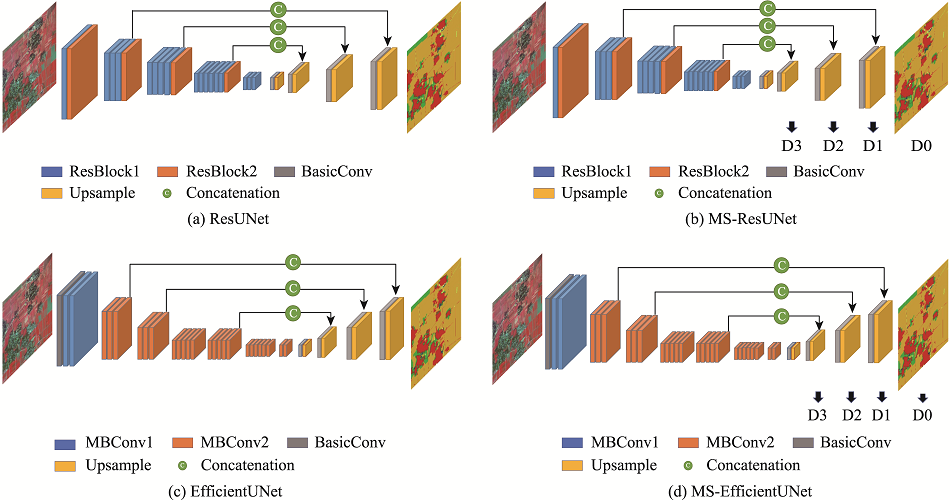
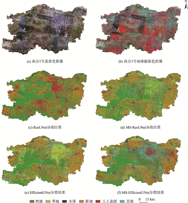
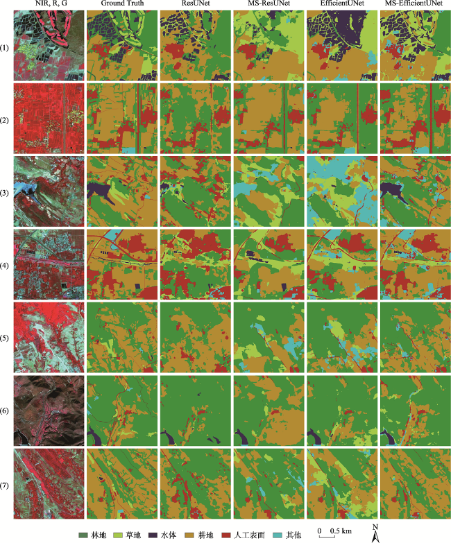
土地覆盖变化是全球变化研究的核心,而精准分类是开展土地覆盖变化研究的基础。高分辨率遥感卫星技术的快速发展对地表分类的速度和精度提出了双重挑战,近年来人工智能等新技术的发展为图像自动分割提供了实现途径,而以卷积神经网络为代表的深度学习方法在遥感图像分类领域也具有独特的优势。为对比深度学习模型设计对高分辨率图像分类结果的影响,本文以郑州市2019年高分1号影像作为输入,对比研究了基于UNet模型改进的4种不同深度学习网络模型在高分辨率影像土地覆盖自动分类应用中的差异,探讨了残差网络、模型损失函数、跳层连接和注意力机制模块等编码和解码设定对于分类精度的影响机制。研究发现:同时加入多尺度损失函数、跳层连接和注意力机制模块的MS-EfficientUNet模型对郑州市土地覆盖分类结果最优,基于像元评价的整体分类精度可达0.7981。通过在解码器中引入多尺度损失函数可有效提高林地、水体和其他类别的分类精度;而对编码器进行改进,加入跳层连接和注意力机制可进一步提高草地、水体和其他类别地物的分类精度。研究结果表明,深度学习技术在高分辨率遥感影像自动分类中具有潜在应用价值,但分类结果精度的进一步提高和多级别大范围的精细分类方法仍是下一步研究的重点。
李国清 , 柏永青 , 杨轩 , 陈正超 , 余海坤 . 基于深度学习的高分辨率遥感影像土地覆盖自动分类方法[J]. 地球信息科学学报, 2021 , 23(9) : 1690 -1704 . DOI: 10.12082/dqxxkx.2021.200795
Land cover change refers to the areal change and type transformation between vegetation cover and non-vegetation cover caused by climate change and human activities, which is closely related to human survival and development, ecological environment evolution, and material energy cycle. Accurate classification is the basis of land cover change while land cover change is the core of global change research. The rapid development of high-resolution remote sensing technology poses a dual challenge to the speed and accuracy of land surface classification. In recent years, the development of new artificial intelligence technology has realized the automatic segmentation of natural scene images. Intelligent image processing technology has become an important force to promote the improvement of remote sensing information service level in the era of big data. The deep learning method represented by the convolution neural network also has significant advantages in the field of remote sensing image classification. To compare the impacts of deep learning model design on the classification results of high-resolution remote sensing images, this paper takes Gaofen-1 images of Zhengzhou City in Henan Province in 2019 as an example. This paper compares and studies the differences of four diverse deep learning network models, improved based on UNet model, in the application of automatic land cover classification of high-resolution images. Furthermore, this paper discusses the influence mechanism of encoder and decoder architecture settings, such as residual network, multi-scale loss function, skip-layer connection, and attention mechanism module, on classification accuracy. The results show that the MS-EfficientUNet model with multi-scale loss function, skip-layer connection, and attention mechanism module is the best for Zhengzhou City land cover classification, with an overall classification accuracy, based on pixel evaluation, of 0.7981. By introducing multi-scale loss function into the decoder, the classification accuracy of the forest, water, and other categories can be effectively improved. Moreover, by improving the encoder, adding skip-layer connection and attention mechanism, the classification accuracy of grassland, water, and other categories can be further improved. The results show that the powerful generalization ability of deep learning technology can effectively break through the spectral and time-phased differences between images, and realize the feature adaptive enhancement and intelligent decision-making, which has great potential in the field of high-resolution remote sensing image segmentation. However, further improvement of classification accuracy and multi-level and large-scale fine classification method are still the focus of the next step. At the same time, the unification of image sequence and the expansion of training samples are also the key factors to further improve the classification accuracy.
表1 ResUNet和MS-ResUNet网络的详细配置Tab. 1 Detailed configuration of the ResUNet and MS-ResUNet |
| ResUNet/MS-ResUNet | 操作 | 卷积核大小 | 输出尺寸/ 像素 |
|---|---|---|---|
| 输入 | — | — | 512×512 |
| 编码器 | Basic Conv | 7×7 | 256×256 |
| Max Pool | 3×3 | 128×128 | |
| Basic ResBlock × 3 | 3×3 | 128×128 | |
| Basic ResBlock × 4 | 3×3 | 64×64 | |
| Basic ResBlock × 6 | 3×3 | 32×32 | |
| Basic ResBlock × 3 | 3×3 | 16×16 | |
| 桥梁 | Basic Conv | 1×1 | 16×16 |
| Upsampling | — | 32×32 | |
| 解码器 | Basic Conv | 3×3 | 32×32 |
| Upsampling | — | 64×64 | |
| Basic Conv | 3×3 | 64×64 | |
| Upsampling | — | 128×128 | |
| Basic Conv | 3×3 | 128×128 | |
| Upsampling | — | 512×512 |
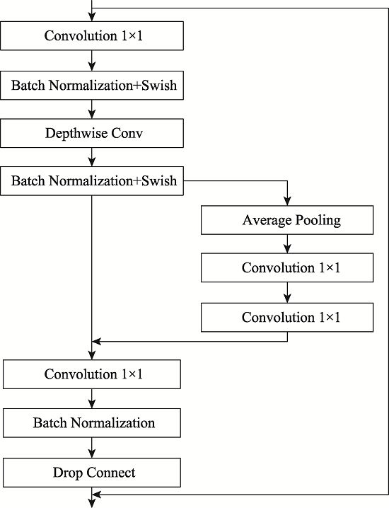
表2 EfficientUNet和MS-EfficientUNet网络的详细配置Tab. 2 Detailed configuration of the EfficientUNet and MS-EfficientUNet |
| EfficientUNet/MS-EfficientUNet | 操作 | 卷积核大小 | 输出尺寸/ 像素 |
|---|---|---|---|
| 输入 | — | — | 512×512 |
| 编码器 | Basic Conv | 3×3 | 256×256 |
| MBConv1 × 2 | 3×3 | 256×256 | |
| MBConv6 × 3 | 3×3 | 128×128 | |
| MBConv6 × 3 | 5×5 | 64×64 | |
| MBConv6 × 5 | 3×3 | 32×32 | |
| MBConv6 × 5 | 5×5 | 32×32 | |
| MBConv6 × 6 | 5×5 | 16×16 | |
| MBConv6 × 2 | 3×3 | 16×16 | |
| 桥梁 | Basic Conv | 1×1 | 16×16 |
| Upsampling | — | 32×32 | |
| 解码器 | Basic Conv | 3×3 | 32×32 |
| Upsampling | — | 64×64 | |
| Basic Conv | 3×3 | 64×64 | |
| Upsampling | — | 128×128 | |
| Basic Conv | 3×3 | 128×128 | |
| Upsampling | — | 512×512 |
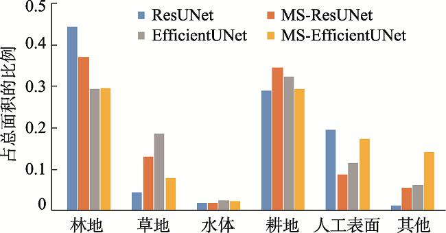
表4 分类结果精度Tab. 4 Accuracy table of classification results |
| 网络模型 | 精度类别 | 林地 | 草地 | 水体 | 耕地 | 人工地表 | 其他 | 平均 |
|---|---|---|---|---|---|---|---|---|
| ResUNet | IoU | 0.4916 | 0.1122 | 0.3791 | 0.6425 | 0.5248 | 0.0684 | 0.3697 |
| F1得分 | 0.6591 | 0.2017 | 0.5498 | 0.7823 | 0.6883 | 0.1280 | 0.5016 | |
| 总体精度 | 0.6551 | |||||||
| MS-ResUNet | IoU | 0.5925 | 0.0951 | 0.5196 | 0.7352 | 0.6128 | 0.3620 | 0.4862 |
| F1得分 | 0.7441 | 0.1737 | 0.6838 | 0.8473 | 0.7599 | 0.5316 | 0.6234 | |
| 总体精度 | 0.7442 | |||||||
| EfficientUNet | IoU | 0.6125 | 0.2218 | 0.6244 | 0.7415 | 0.6489 | 0.3986 | 0.5412 |
| F1得分 | 0.7513 | 0.3785 | 0.7652 | 0.8189 | 0.7682 | 0.5978 | 0.6799 | |
| 总体精度 | 0.7712 | |||||||
| MS-EfficientUNet | IoU | 0.6557 | 0.2902 | 0.6439 | 0.7801 | 0.6915 | 0.4577 | 0.5865 |
| F1得分 | 0.7920 | 0.4498 | 0.7833 | 0.8764 | 0.8176 | 0.6280 | 0.7245 | |
| 总体精度 | 0.7981 | |||||||
| [1] |
全国科学技术名词审定委员会. 生态学名词[M]. 北京: 科学出版社, 2007.
[ China National Committee for Terms in Sciences and Technologies. Chinese Terms in Ecology[M]. Beijing: Science Press, 2007. ]
|
| [2] |
张景华, 封志明, 姜鲁光. 土地利用/土地覆被分类系统研究进展[J]. 资源科学, 2011, 33(6):1195-1203.
[
|
| [3] |
|
| [4] |
|
| [5] |
徐勇, 赵燊, 段健. 国土空间规划的土地利用分类方案研究[J]. 地理研究, 2019, 38(10):2388-2401.
[
|
| [6] |
|
| [7] |
黎治华, 高志强, 高炜, 等. 上海近十年来城市化及其生态环境变化的评估研究[J]. 国土资源遥感, 2011, 23(2):124-129.
[
|
| [8] |
吴炳方, 苑全治, 颜长珍, 等. 21世纪前十年的中国土地覆盖变化[J]. 第四纪研究, 2014, 34(4):723-731.
[
|
| [9] |
董立新, 吴炳方, 郭振华, 等. 三峡库区农林用地变化遥感监测及模拟预测[J]. 农业工程学报, 2009, 25(S2):290-297,351.
[
|
| [10] |
李元春, 葛静, 侯蒙京, 等. 基于CCI-LC数据的甘南和川西北地区土地覆盖类型时空动态分布及草地面积变化驱动力研究[J]. 草业学报, 2020, 29(3):1-15.
[
|
| [11] |
刘炜. 土地利用/覆被变化信息遥感图像自动分类识别与提取方法研究[D]. 杨凌:西北农林科技大学, 2012.
[
|
| [12] |
|
| [13] |
|
| [14] |
|
| [15] |
|
| [16] |
席一帆, 孙乐乐, 何立明, 等. 基于改进Deeplab V3+网络的语义分割[J]. 计算机系统应用, 2020, 29(9):178-183.
[
|
| [17] |
|
| [18] |
|
| [19] |
|
| [20] |
|
| [21] |
|
| [22] |
|
| [23] |
|
| [24] |
|
| [25] |
|
| [26] |
|
| [27] |
|
| [28] |
李宏达, 高小红, 汤敏. 基于CNN的不同空间分辨率影像土地覆被分类研究[J]. 遥感技术与应用, 2020, 35(4):749-758.
[
|
| [29] |
|
| [30] |
董秀春, 蒋怡, 王思, 等. 基于U-Net的甘蔗提取方法[J]. 中国农业信息, 2019, 31(6):29-34.
[
|
| [31] |
杨瑞, 祁元, 苏阳. 深度学习U-Net方法及其在高分辨卫星影像分类中的应用[J]. 遥感技术与应用, 2020, 35(4):767-774.
[
|
| [32] |
林志斌, 黄智全, 颜林明. 基于Unet的高分辨率遥感图像地物分类[J]. 电子质量, 2020(11):69-76.
[
|
| [33] |
李海雷, 胡小娟, 郭杭, 等. 迁移学习支持下的土地利用/土地覆被分类[J]. 测绘通报, 2018(9):50-54,73.
[
|
| [34] |
|
| [35] |
|
| [36] |
|
| [37] |
郑州市统计局. 2019年郑州市国民经济和社会发展统计公报[R], 2019.
[ Zhengzhou Bureau of Statistics. Statistical bulletin of national economic and social development of Zhengzhou in 2019[R], 2019. ]
|
| [38] |
曹丽琴. 郑州市水文特性分析[J]. 河南水利与南水北调, 2006(8):29-30.
[
|
| [39] |
杜子璇, 刘忠阳, 陈怀亮, 等. 1993—2003年郑州市土地利用/覆被变化特征研究[J]. 气象与环境科学, 2007, 30(1):49-53.
[
|
| [40] |
吴炳方. 中华人民共和国土地覆被地图集(1:1 000 000)[M]. 北京: 中国地图出版社, 2017.
[
|
| [41] |
张玮. 土地利用/覆被分类与碳储量研究——以青藏高原为例[D]. 北京:中国科学院地理科学与资源研究所, 2007.
[
|
| [42] |
林煜东. 复杂背景下的光学遥感图像目标检测算法研究[D]. 成都:西南交通大学, 2017.
[
|
| [43] |
王敏, 陈金勇, 王港, 等. 面向深度学习的遥感图像目标样本生成方法[J]. 国外电子测量技术, 2019, 38(4):60-65..
[
|
| [44] |
周志华. 机器学习[M]. 北京: 清华大学出版社, 2016.
[
|
| [45] |
苏育挺, 王明兴, 张静. 一种提升矢量图位图分类精确度的方法: CN109948659A[P]. 2019-06-28.
[
|
/
| 〈 |
|
〉 |
