
一种与地图服务结合的栅格瓦片计算模型
|
胡毅荣(1994— ),男,浙江嘉兴人,硕士生,主要从事地理大数据存储与计算研究。E-mail: huyirong_mail@163.com |
收稿日期: 2021-01-18
要求修回日期: 2021-03-13
网络出版日期: 2021-12-25
基金资助
国家重点研发计划项目(2018YFB0505000)
国家自然科学基金项目(41922043)
国家自然科学基金项目(41871287)
国家自然科学基金项目(42001323)
版权
A Raster Tile Calculation Model Combined with Map Service
Received date: 2021-01-18
Request revised date: 2021-03-13
Online published: 2021-12-25
Supported by
National Key Research and Development Program of China(2018YFB0505000)
National Natural Science Foundation of China(41922043)
National Natural Science Foundation of China(41871287)
National Natural Science Foundation of China(42001323)
Copyright
随着遥感影像数据的快速增长,对于栅格数据高效的信息处理和价值挖掘方式提出了更大的挑战,传统地图服务聚焦于内容的共享与可视化,缺乏对影像实时分析处理功能。本研究以地图服务的形式实现了对栅格瓦片数据实时分析处理能力,将云优化的GeoTIFF(Cloud Optimized GeoTIFF,COG)作为数据组织方式,设计了分布式协同预取策略,实现了栅格瓦片数据的冷热加载,优化了从云端读取影像数据的效率。在栅格瓦片数据高效加载的基础下,提出了一种基于表达式的栅格瓦片处理模型,通过对表达式转换建模为计算工作流,在地图服务的请求中实现对栅格瓦片的实时处理,对存储在云端的海量遥感数据进行快速分析,实现原始数据到数据产品的直接可视化转换。针对全量数据参与的场景,使用合适的重采样数据进行简化计算,以满足地图服务的实时性。使用了NDVI、地物分类、植被覆盖度三类不同复杂度模型,在地图服务中对Landsat 8影像进行了实时计算分析。实验结果表明,该处理模型能对栅格瓦片进行有效分析,且能进行分布式扩展,在高并发场景下能够提供稳定的地图服务能力,适应各层级尺度的计算,对未来地图服务的发展提供了一种新思路。
胡毅荣 , 王超 , 杜震洪 , 张丰 , 刘仁义 . 一种与地图服务结合的栅格瓦片计算模型[J]. 地球信息科学学报, 2021 , 23(10) : 1756 -1766 . DOI: 10.12082/dqxxkx.2021.210029
With the rapid growth of remote sensing data, greater challenges arise in raster data efficient processing and value mining. Traditional map services focus on content sharing and visualization, but lacking real-time image analysis and processing functions. In this study, the real-time analysis and processing capabilities of raster tile data are realized in the form of map service. The cloud optimized GeoTIFF (Cloud Optimized GeoTIFF, COG) is used as the data organization method. The distributed collaborative prefetching strategy is designed to realize the raster tile loading in a cold or hot way, which optimizes the efficiency of reading image data from the cloud. Based on the efficient raster tile data loading, an expression-based raster tile processing model is proposed. By converting the expression into a calculation workflow, the raster tile is processed in the request of the map service in real time. The massive remote sensing data stored in the cloud is quickly analyzed to realize the direct visual conversion from raw data to products. For scenarios where full data are involved, use appropriate resampling data to simplify calculations to meet the real-time performance of map services. Three types of different complexity models, NDVI, ground object classification, and fractional vegetation cover, are used to perform real-time calculation and analysis on Landsat 8 images in the map service. Experimental results show that the processing model can effectively analyze raster tiles, and can be extended in a distributed manner. It can provide stable map service capabilities in high-concurrency scenarios, adapt to calculations at various levels and scales, and contribute a new idea to the future development of map service.
表1 3种地图服务瓦片特点Tab. 1 Three map service tiles feature |
| 地图服务瓦片类型 | 瓦片生成方式 | 数据读取方式 | 具备分析性 |
|---|---|---|---|
| 静态瓦片 | 预生成静态图片 | 直接读取静态图片,性能高 | 否 |
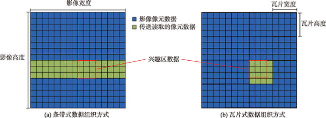
| GIS服务器生成的瓦片 | 实时读取本地影像 | 条带状读取,性能低 | 是 |
| 基于COG生成的瓦片 | 实时读取云端影像 | 瓦片式读取,性能高 | 是 |
表2 用于栅格瓦片处理的基础函数Tab. 2 Basic function for raster tile processing |
| 函数类型 | 操作函数名 |
|---|---|
| 基本运算 | 加(add)、减(sub)、乘(mul)、除(sub) |
| 三角函数 | 正弦(sin)、余弦(cos)、正切(tan)反正弦(asin)、反余弦(acos)、反正切(atan) |
| 其他数学函数 | 平方根(sqrt)、绝对值(abs)、自然指数(exp)、最大值(Max)、最小值(Min) |
| 全局函数 | 全局最大值(GMax)、全局最小值(GMin) |
| 指数函数 | 归一化植被指数(NDVI)、归一化水指数(NDWI) |
表3 Landsat 8数据列表Tab. 3 Landsat 8 data list |
| 标识编号 | 云量% |
|---|---|
| LC81200362020115LGN00 | 0.10 |
| LC81190362020092LGN00 | 0.15 |
| LC81190382020252LGN00 | 2.12 |
| LC81190372020236LGN00 | 6.98 |
| LC80960432021013LGN00 | 7.97 |
| LC81200372020291LGN00 | 15.71 |
表4 影像瓦片读取性能Tab. 4 Image tile reading performance |
| 存储位置 | 影像组织格式 | 每张瓦片平均读取时间消耗(Zoom)/ms | ||||
|---|---|---|---|---|---|---|
| 8 | 10 | 12 | 14 | 16 | ||
| 本地固态硬盘 | GeoTIFF | 4864 | 402 | 82 | 48 | 39 |
| COG | 84 | 153 | 177 | 42 | 34 | |
| HDFS | GeoTIFF | 9677 | 7725 | 2097 | 102 | 68 |
| COG | 104 | 180 | 207 | 53 | 45 | |
表5 影像瓦片测试数量Tab. 5 Image tile test quantity |
| Zoom层级 | WGS84瓦片空间编号范围 | 瓦片 数量/个 | |||
|---|---|---|---|---|---|
| XMin | YMin | XMax | YMax | ||
| 10 | 849 | 417 | 856 | 424 | 64 |
| 11 | 1699 | 835 | 1713 | 849 | 225 |
| 12 | 3399 | 1671 | 3427 | 1699 | 841 |
| 13 | 6799 | 3343 | 6854 | 3399 | 3192 |
| 14 | 13 599 | 6687 | 13 709 | 6799 | 12 543 |
| 15 | 27 199 | 13 375 | 27 418 | 13 599 | 49 500 |
| 16 | 54 398 | 26 750 | 54 837 | 27 199 | 198 000 |
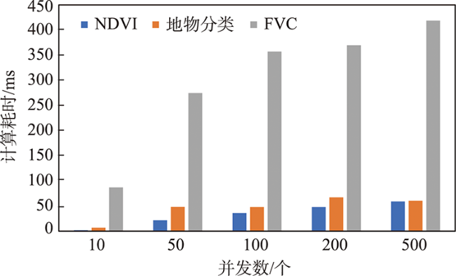
表6 不同并发数下各阶段效率对比Tab. 6 Comparison of the efficiency of each stage under different concurrency |
| 并发度 | 计算模型 | 单个瓦片平均消耗时间/ms | ||
|---|---|---|---|---|
| 瓦片获取 | 计算 | 渲染 | ||
| 10 | NDVI | 21.0 | 1.8 | 17.9 |
| 地物分类 | 57.2 | 6.9 | 18.5 | |
| FVC | 26.1 | 87.1 | 20.1 | |
| 50 | NDVI | 69.0 | 21.5 | 55.9 |
| 地物分类 | 203.1 | 48.2 | 49.6 | |
| FVC | 76.5 | 274.8 | 49.3 | |
| 100 | NDVI | 120.3 | 36.0 | 73.8 |
| 地物分类 | 273.8 | 47.9 | 54.5 | |
| FVC | 108.1 | 357.3 | 69.7 | |
| 200 | NDVI | 109.2 | 48.0 | 87.7 |
| 地物分类 | 259.4 | 67.1 | 76.9 | |
| FVC | 156.3 | 369.7 | 91.2 | |
| 500 | NDVI | 172.2 | 59.1 | 100.6 |
| 地物分类 | 328.9 | 60.4 | 99.1 | |
| FVC | 226.6 | 418.9 | 107.4 | |
| 1000 | NDVI | 294.5 | 64.5 | 113.1 |
| 地物分类 | 532.4 | 69.3 | 105.2 | |
| FVC | 407.3 | 450.0 | 119.8 | |
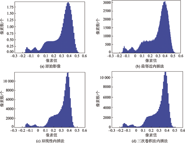
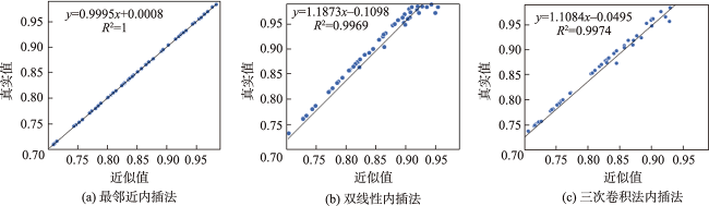
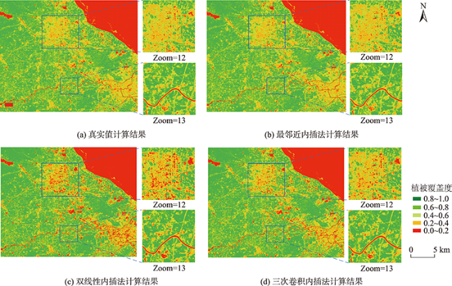
表7 FVC计算数据Tab. 7 VFC calculation data |
| 全局数据 | 5%置信度值 | 95%置信度值 | 平均误差率/% |
|---|---|---|---|
| 原始影像 | -0.0397 | 0.4603 | - |
| 最邻近内插法overview | -0.0401 | 0.4602 | 0.11 |
| 双线性内插法overview | 0.0153 | 0.4205 | 7.40 |
| 三次卷积内插法overview | -0.0060 | 0.4267 | 6.41 |
| [1] |
|
| [2] |
|
| [3] |
|
| [4] |
|
| [5] |
|
| [6] |
|
| [7] |
|
| [8] |
|
| [9] |
|
| [10] |
王浩, 喻占武, 曾武, 等. 网络地理信息服务中的空间数据缓存算法研究[J]. 测绘学报, 2009, 38(4):348-355.
[
|
| [11] |
|
| [12] |
|
| [13] |
|
| [14] |
|
| [15] |
|
| [16] |
|
| [17] |
|
| [18] |
|
| [19] |
|
| [20] |
|
| [21] |
|
| [22] |
张瀚文. 大规模影像数据集瓦片金字塔快速构建技术[D]. 湖南:国防科技大学, 2017.
[
|
| [23] |
陆晔, 张伟, 李飞, 等. 一种基于主题时空价值的服务器端瓦片缓存算法[J]. 浙江大学学报(理学版), 2020, 47(1):12-19.
[
|
| [24] |
许虎, 聂云峰, 舒坚. 基于中间件的瓦片地图服务设计与实现[J]. 地球信息科学学报, 2010, 12(4):562-567.
[
|
| [25] |
|
| [26] |
|
| [27] |
李苗苗. 植被覆盖度的遥感估算方法研究[D]. 中国科学院研究生院(遥感应用研究所), 2003.
[
|
| [28] |
[
|
| [29] |
鲍文东, 杨春德, 邵周岳, 等. 几何精校正中三种重采样内插方法的定量比较[J]. 测绘通报, 2009(3):71-72.
[
|
/
| 〈 |
|
〉 |
