
基于多智能体的城市洪涝灾害动态脆弱性计算模型构建
|
朱净萱(1997— ),女,山西太原人,硕士生,主要从事城市洪涝灾害研究。E-mail: catar1213@foxmail.com |
收稿日期: 2021-01-29
要求修回日期: 2021-04-11
网络出版日期: 2021-12-25
基金资助
国家自然科学基金项目(41871299)
国家自然科学基金项目(41771424)
国家自然科学基金项目(42071364)
版权
An Agent-based Computing Model of Urban Vulnerability to Flood Hazard
Received date: 2021-01-29
Request revised date: 2021-04-11
Online published: 2021-12-25
Supported by
National Natural Science Foundation of China(41871299)
National Natural Science Foundation of China(41771424)
National Natural Science Foundation of China(42071364)
Copyright
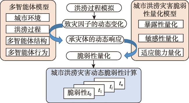
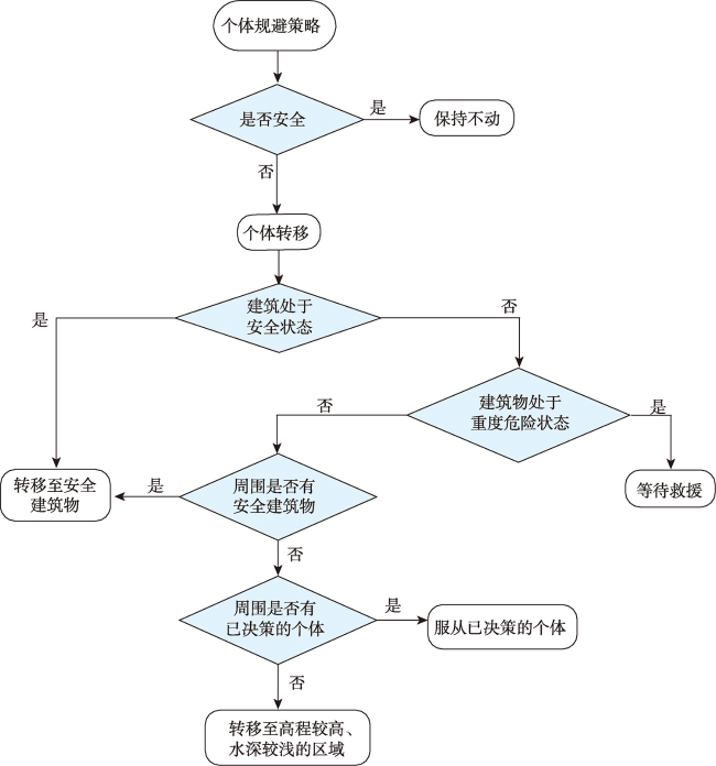
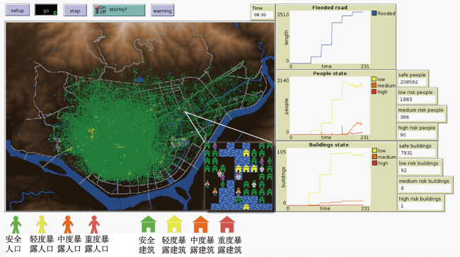
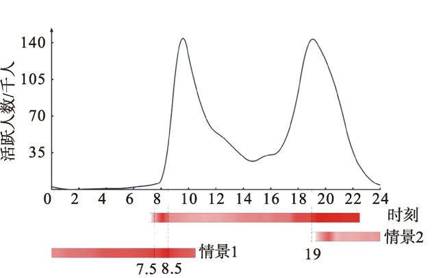
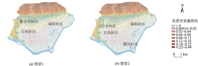
随着全球气候变化加剧和城市化进程的发展,暴雨洪涝灾害对城市社会经济活动造成的影响越来越严重。作为量化灾害影响程度、社会经济损失与风险评估的重要方法,城市洪涝灾害脆弱性研究对洪涝灾害风险管理与规划具有重要意义。目前,城市脆弱性的内涵进一步延伸,脆弱性指标体系不断丰富,所取得的研究成果能够反映一定时期内城市洪涝灾害脆弱性的整体特征,却无法同时有效地解决城市洪涝灾害脆弱性的空间非均匀性问题和动态计算问题。本文从脆弱性的动态特征出发,提出了城市洪涝灾害动态脆弱性计算方法,建立了城市洪涝灾害脆弱性量化模型与面向洪涝灾害脆弱性计算的多智能体模型,形成了基于多智能体的城市洪涝灾害脆弱性计算方法。在NetLogo平台上,利用智能体模型对浙江省丽水市城区的动态脆弱性进行了仿真模拟。研究结果表明该模型有助于发现不同时空条件下城市存在的“脆弱区”,为城市洪涝灾害脆弱性的时空分异特征分析、区域脆弱性的精细化评价提供方法支撑,能够为缓解措施的实施和洪涝灾害的精细化管理提供有效指导。
朱净萱 , 戴强 , 蔡俊逸 , 朱少楠 , 张书亮 . 基于多智能体的城市洪涝灾害动态脆弱性计算模型构建[J]. 地球信息科学学报, 2021 , 23(10) : 1787 -1797 . DOI: 10.12082/dqxxkx.2021.210053
With the intensification of global climate change and the development of urbanization, the impact of heavy rains and floods on urban social and economic activities has become serious. As an important method to quantify the hazard impact and socio-economic loss, and to conduct risk assessment in urban hazard research, study on Urban Vulnerability to Flood Hazard (UVFH) is of great significance to flood risk management and planning. It can also contribute to interpretation of "human-earth" relationship and the effect of human activities on eco-environmental systems through geography and other related disciplines. Recent research has extended the connotation of vulnerability and enriched the indicator system. Their findings can reflect the overall features of urban vulnerability in a period. However, the current studies are still incapable of achieving vulnerability evaluation considering spatial heterogeneity and dynamic characteristic simultaneously. Therefore, in view of the research on flood hazard vulnerability, this paper proposed an agent-based computing model for UVFH calculation by considering its dynamic characteristics. Firstly, after analyzing the dynamic characteristics of UVFH, the computing framework of UVFH is designed, which sets up the quantitative model, and puts forward an agent-based computing method of UVFH. This framework models the flood hazard in four parts: urban environment, flood simulation, agents, and multi-agents' behaviors. Various environmental and socio-economic indicators are selected comprehensively to quantify the urban exposure, susceptibility, and adaptability. Secondly, by coupling the LISFLOOD-FP and SWMM model, the dynamic changes of hazard drivers are simulated. Moreover, the multi-agents' behaviors are designed to simulate hazard bearers' response to flood hazard. By computing the dynamic indicators of exposure and susceptibility, the UVFH can be simulated dynamically. The agent-based computing method highlights the dynamic characteristics of UVFH, thus can be used to simulate different scenarios. Thirdly, taking the Liandu District in Lishui City, Zhejiang Province as an example, two scenarios of 50-year flood hazards with different occurrence times were designed on the NetLogo platform. The results showed that the occurrence time of flood hazard made a difference to overall vulnerability, and people's daily routines had a great impact on the degree and distribution of vulnerability. Moreover, the contributions of exposure, susceptibility, and adaptability to vulnerability varied in places. The agent-based computing model of UVFH proposed by this paper can help discover the “vulnerable zone” of a city, and provide methodological supports for the spatio-temporal variation analysis of UVFH and the assessment of regional dynamic vulnerability, thus providing effective guidance for refined flood hazard management.
表1 地表因子Tab. 1 Debris factor for areas |
| 限制条件 | 草地/耕地 | 林地/森林 | 城市 |
|---|---|---|---|
| 0 < H ≤ 0.25 m | 0 | 0 | 0 |
| 0.25 m< H ≤ 0.75 m | 0 | 0.5 | 1 |
| H > 0.75 m/s或V > 2 m/s | 0.5 | 1 | 1 |
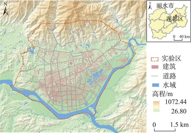
表2 实验数据Tab. 2 Experimental data set |
| 类型 | 来源 | 时间 | 名称 | 描述 |
|---|---|---|---|---|
| 基础地理信息数据 | 丽水市地理信息中心 | 2015 | 数字高程模型 | DEM(分辨率20 m×20 m) |
| 地下排水管网 | 包括检查井、出水口、雨水线、排水线 | |||
| 水系 | 瓯江支流、湖泊、水库、河渠等 | |||
| 道路 | 城区主干道 | |||
| 建筑 | 城区主要建筑物 | |||
| 组织机构位置点 | 学校、卫生医疗机构、应急救援单位等 | |||
| 社会经济数据 | 国家地球系统科学数据中心[33] | 2015 | 格网人口数据 | 中国1 km格网人口栅格数据 |
| 地方统计年鉴2015[34,35] | 2014 | 人口特征信息 | 性别比例、老年人比例、儿童比例、低保人口、残疾人口、失业人口等 | |
| 经济统计数据 | GDP、人均可支配收入等 | |||
| 丽水市交通局 | 2017-06-24至2017-07-07 | 交通流量数据 | 部分道路路口实测交通流量 | |
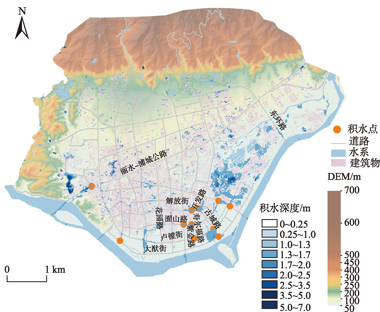
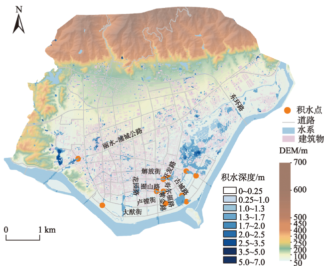
| 历史灾情数据 | 丽水市住房和 城乡建设局 | 2014 | 积水点信息 | 历史洪涝灾害积水水深等 |
表3 个体智能体分类Tab. 3 Resident agent classification |
| 分类 | ||||
|---|---|---|---|---|
| 性别 | 年龄 | 身体状况 | 就业情况 | 可支配收入 |
| 男 | 0~18 | 健康 | 就业 | 人均可支配收入 |
| 女 | 18~65 | 残疾 | 未就业 | 无收入 |
| ˃65 | ||||
| [1] |
蒋卫国, 李京, 陈云浩, 等. 区域洪水灾害风险评估体系(Ⅰ)——原理与方法[J]. 自然灾害学报, 2008, 17(6):53-59.
[
|
| [2] |
民政部. 民政部国家减灾办发布2016年全国自然灾害基本情况[EB/OL]. http://www.mca.gov.cn/article/xw/mzyw/201701/20170115002965.shtml 2017.
[ Ministry of Civil Affairs. National Disaster Reduction Office of Ministry of Civil Affairs has published the 2016 national natural disaster general information[EB/OL]. http://www.mca.gov.cn/article/xw/mzyw/201701/20170115002965.shtml 2017. ]
|
| [3] |
民政部. 民政部国家减灾办发布2017年全国自然灾害基本情况[EB/OL]. http://www.mca.gov.cn/article/xw/mzyw/201802/20180215007709.shtml 2018.
[ Ministry of Civil Affairs. National Disaster Reduction Office of Ministry of Civil Affairs has published the 2017 national natural disaster general information[EB/OL]. http://www.mca.gov.cn/article/xw/mzyw/201802/20180215007709.shtml 2018. ]
|
| [4] |
|
| [5] |
|
| [6] |
|
| [7] |
|
| [8] |
|
| [9] |
刘耀龙, 陈振楼, 王军, 等. 经常性暴雨内涝区域房屋财(资)产脆弱性研究——以温州市为例[J]. 灾害学, 2011, 26(2):66-71.
[
|
| [10] |
葛全胜, 邹铭, 郑景云. 中国自然灾害风险综合评估初步研究[M]. 北京: 科学出版社, 2008.
[
|
| [11] |
|
| [12] |
郭桂祯, 赵飞, 王丹丹. 基于脆弱性曲线的台风-洪涝灾害链房屋倒损评估方法研究[J]. 灾害学, 2017, 32(4):94-97.
[
|
| [13] |
温泉沛, 周月华, 霍治国, 等. 湖北暴雨洪涝灾害脆弱性评估的定量研究[J]. 中国农业气象, 2018, 39(8):547-557.
[
|
| [14] |
|
| [15] |
|
| [16] |
|
| [17] |
|
| [18] |
尹占娥, 暴丽杰, 殷杰. 基于GIS的上海浦东暴雨内涝灾害脆弱性研究[J]. 自然灾害学报, 2011, 20(2):29-35.
[
|
| [19] |
|
| [20] |
|
| [21] |
黄河, 范一大, 杨思全, 等. 基于多智能体的洪涝风险动态评估理论模型[J]. 地理研究, 2015, 34(10):1875-1886.
[
|
| [22] |
李文波, 郭啸天, 毛雪岷, 等. 基于多智能体的暴雨洪涝人口风险动态评估[J]. 灾害学, 2015, 30(3):80-87.
[
|
| [23] |
|
| [24] |
|
| [25] |
|
| [26] |
|
| [27] |
|
| [28] |
袁海红, 高晓路. 城市经济脆弱性评价研究——以北京海淀区为例[J]. 自然资源学报, 2014, 29(7):1159-1172.
[
|
| [29] |
黄晓军, 黄馨, 崔彩兰, 等. 社会脆弱性概念、分析框架与评价方法[J]. 地理科学进展, 2014, 33(11):1512-1525.
[
|
| [30] |
王录仓, 史凯文, 梁珍. 城市脆弱性综合评价与动态演变研究——以兰州市为例[J]. 生态经济, 2017, 33(9):137-141.
[
|
| [31] |
Defra. Flood risk to people phase 2[M]. Food and Rural Affairs, FD2321/TR2 Guidance Document, London: Department for Environment, 2006.
|
| [32] |
中国科学院地理科学与资源研究所. 中国公里格网人口数据(2015年)[DB/OL]. 国家科技基础条件平台—国家地球系统科学数据共享服务平台 (http://www.geodata.cn 2019.
[ Institute of Geographic Sciences and Natural Resources Research, CAS. 1 kilometer grid population data in China (2015)[DB/OL]. National Earth System Science Data Center, National Science & Technology Infrastructure of China (http://www.geodata.cn 2019. ]
|
| [33] |
丽水市统计局. 丽水统计年鉴——2015[M]. 北京: 中国统计出版社, 2015.
[ Liandu District Statistics Bureau. Lishui Statistical Yearbook-2015[M]. Beijing: Chinese Statistics Press, 2015. ]
|
| [34] |
丽水市莲都区统计局. 莲都年鉴.2015[M]. 北京: 方志出版社, 2015.
[ Liandu District Statistics Bureau. Liandu Statistical Yearbook 2015[M]. Beijing: Local records Publishing House, 2015. ]
|
| [35] |
|
| [36] |
|
| [37] |
|
| [38] |
毛海虓. 中国城市居民出行特征研究[D]. 北京:北京工业大学, 2005.
[
|
| [39] |
张文佳, 柴彦威. 基于家庭的城市居民出行需求理论与验证模型[J]. 地理学报, 2008, 63(12):1246-1256.
[
|
/
| 〈 |
|
〉 |