
南海区域渔船活动时空特征分析
|
贺彬(1995- ), 男,陕西渭南人,研究生,主要从事AIS数据挖掘研究。E-mail: heb@lreis.ac.cn. |
收稿日期: 2020-12-19
要求修回日期: 2021-03-27
网络出版日期: 2022-01-25
基金资助
国家自然科学基金项目(4200617)
中国科学院战略性先导科技专项(XDA13010400)
国家自然科学基金重大项目(41890854)
版权
Analysis of the Spatio-Temporal Characteristics of Fishing Vessels Activities in the South China Sea
Received date: 2020-12-19
Request revised date: 2021-03-27
Online published: 2022-01-25
Supported by
National Natural Science Foundation of China, No(4200617)
Strategic Priority Research Program of Chinese Academy of Sciences, No.(XDA13010400)
National Natural Science Foundation of China, No(41890854)
Copyright
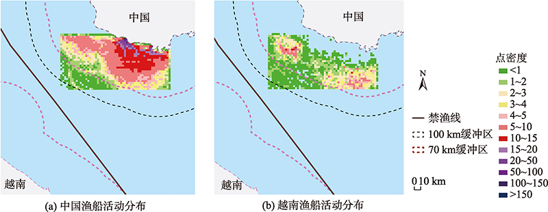
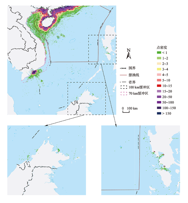
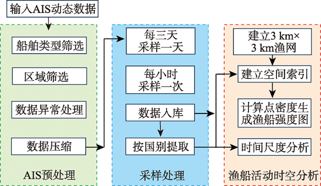
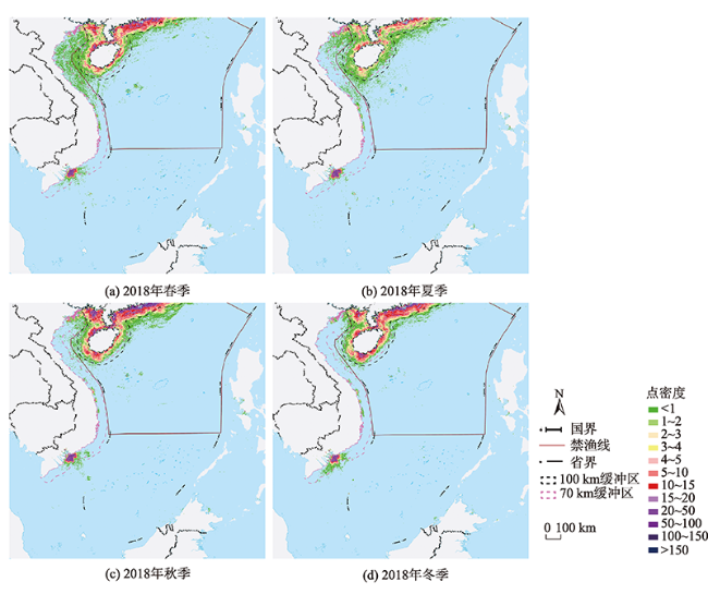
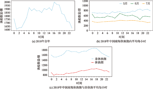
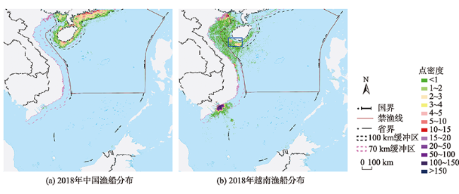
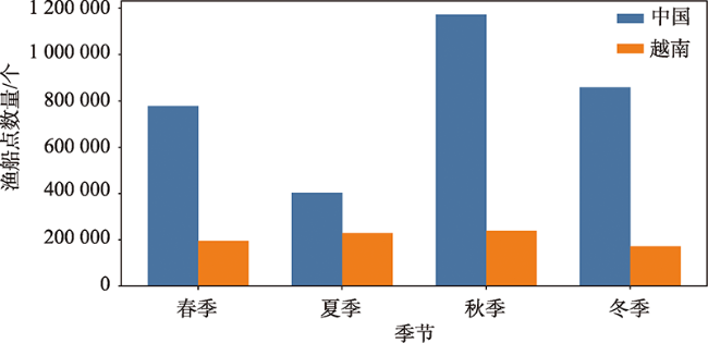
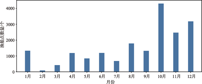
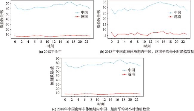
近年来海洋资源的不断开发利用,使得海洋空间规划变得尤为重要,其中以渔业资源占主要比重。为了对渔业资源监测与规划提供辅助决策信息,本文通过对南海及周边国家2018年船舶自动识别系统(AIS)数据进行预处理,采用数理统计和GIS空间分析方法,实现了南海区域渔船活动强度时空特征分析。结果显示: ① 2018年南海及周边国家渔船以区域性分布为主,集中在中国和越南沿海岸100 km以内区域,在秋季11月捕捞活动频繁,全年渔船平均活动强度白天大于夜晚,16:00 PM 时达到最大渔船活动强度; ② 中国在广东省、广西省和海南省各主要港口渔船活动强度呈现聚集性点状分布,渔船活动强度多大于100,部分港口附近海域呈条带状分布,西沙群岛相较南海其他群岛渔船活动强度较大,除越南外其他周边国家靠近南海附近海域部分海湾和港口有聚集式分布,渔船活动强度都小于2; ③ 越南渔船区域性分布明显,在胡志明港口呈现稳定的块状聚集性分布,且一年四季活动强度变化趋势不大,近岸渔船活动强度保持在50~100,越南渔船在中国南海禁渔线内靠近海南省西南部有两处活动较强的块状分布区域,2018年全年在此区域活动频率占采样天数的87.71%,且平均每小时有7~10艘渔船在该海域活动,休渔期内平均每小时渔船数量大于5,给中国南海海域渔业资源造成巨大威胁。本文通过AIS数据研究分析渔船活动可为海洋空间规划与政府相关部门提供数据支撑。
贺彬 , 吴文周 , 康路 , 苏奋振 . 南海区域渔船活动时空特征分析[J]. 地球信息科学学报, 2021 , 23(11) : 2013 -2024 . DOI: 10.12082/dqxxkx.2021.200770
In recent years, with the continuous exploitation and utilization of marine resources, marine spatial planning has become more and more important, among which fishery resources account for the main proportion. In order to provide auxiliary information for the monitoring and planning of fishery resources, this paper obtained the 2018 Automatic Identification System data of the South China Sea and surrounding countries, extracted the activity intensity of fishing vessels and carried out preprocessing, sampling processing, and GIS spatial analysis, and then mathematically analyzed the spatial and temporal characteristics. The results showed that, firstly, in 2018, fishing vessels in the South China Sea and surrounding countries were mainly distributed regionally, concentrated in areas within 100 km of the coast of China and Vietnam. Fishing activities were frequent in autumn and November. The average activity intensity of fishing vessels was higher during the day than at night, with the maximum activity intensity at 16:00 PM; Secondly, the intensity of fishing activities in main ports of Guangdong, Guangxi, and Hainan provinces is clustered as dots, with the intensity of fishing activities bigger than 100. The sea area near some ports is striped, and the intensity of activities of other fishing vessels in the South China Sea is larger than that of other islands in the Paracel Islands. The activity intensity of fishing vessels is smaller than 2; Thirdly, the regional distribution of Vietnamese fishing activities is obvious, showing a stable mass clustering distribution in Ho Chi Minh Port, with little change in activity intensity throughout the year. The activity intensity of nearshore fishing vessels remains at 50~100. Vietnamese fishing vessels are banned in the South China Sea. There are two areas with strong activity in the southwestern part of Hainan Province within the fishing line. In 2018, days with fishing activity accounted for 87.71% of the total sampling days, with on average 7~10 fishing boats every hour in the area. During the moratorium period, the average number of boats every hour is bigger than 5, which poses a great threat to China's south China sea fishery resources. In this paper, AIS data research and analysis of fishing vessel activities can provide data support for marine spatial planning and relevant government departments.
表1 部分国家与地区的MID编码Tab. 1 MID of some countries and regions |
| 国家和地区 | 编码 |
|---|---|
| 中国 | 412,413,414 |
| 澳门(中华人民共和国特别行政区) | 453 |
| 香港(中华人民共和国特别行政区) | 477 |
| 中国台湾 | 416 |
| 菲律宾 | 548 |
| 越南 | 574 |
| 马来西亚 | 533 |
| 文莱 | 508 |
| [1] |
雷霁霖. 中国海水养殖大产业架构的战略思考[J]. 中国水产科学, 2010, 17(3):600-609.
[
|
| [2] |
张君珏, 苏奋振, 王雯玥. 南海资源环境地理研究综述[J]. 地理科学进展, 2018, 37(11):1443-1453.
[
|
| [3] |
杨红生. 我国海洋牧场建设回顾与展望[J]. 水产学报, 2016, 40(7):1133-1140.
[
|
| [4] |
郭刚刚, 樊伟, 薛嘉伦, 等. 基于NPP/VIIRS夜光遥感影像的作业灯光围网渔船识别[J]. 农业工程学报, 2017, 33(10):245-251.
[
|
| [5] |
吴佳文, 官文江. 基于SNPP/VIIRS夜光遥感数据的东、黄海渔船时空分布及其变化特点[J]. 中国水产科学, 2019, 26(2):221-231.
[
|
| [6] |
|
| [7] |
|
| [8] |
|
| [9] |
|
| [10] |
|
| [11] |
陈金海, 陆锋, 李明晓. 海上主航迹带边界统计推断与海西航路警戒区布局优化分析[J]. 地球信息科学学报, 2015, 17(10):1196-1206.
[
|
| [12] |
何正伟, 杨帆, 刘力荣. 基于AIS数据的船舶安全航行水深参考图[J]. 交通运输工程学报, 2018, 18(4):171-181.
[
|
| [13] |
|
| [14] |
|
| [15] |
王坚, 黄厔, 刘艳英, 等. 厦门市船舶控制区大气污染物排放清单与污染特征[J]. 环境科学, 2020, 41(8):3572-3580.
[
|
| [16] |
梅强, 吴琳, 彭澎, 等. 南海区域商船典型空间分布及贸易流向研究[J]. 地球信息科学学报, 2018, 20(5):632-639.
[
|
| [17] |
|
| [18] |
|
| [19] |
刘奥博, 程晓. 基于星载AIS数据的南极半岛地区人类活动分析[J]. 极地研究, 2019, 31(4):456-463.
[
|
| [20] |
|
| [21] |
杨胜龙, 张胜茂, 原作辉, 等. 基于渔船捕捞行为特征的远洋延绳钓渔场捕捞强度计算[J]. 中国水产科学, 2020, 27(3):307-314.
[
|
| [22] |
|
| [23] |
|
| [24] |
陈仁丽, 王宜强, 刘柏静, 等. 基于GIS和AIS的渤海海上船舶活动时空特征分析[J]. 地理科学进展, 2020, 39(7):1172-1181.
[
|
/
| 〈 |
|
〉 |

